Woodlands Farm, Caldwell, Richmond
- Land size
- 13.59 acres
- Bedrooms
- 3
- Bathrooms
- 1
Key Features
- Traditional, stone built , three bedroom farmhouse
- A mixed range of traditional and modern farm buildings including stables, general storage and livestock housing
- Productive agricultural land, extending in total to 12.55 acres
- About 13.59 acres (5.50 hectares) in total
- For Sale As A Whole
Description
A charming smallholding with a three bedroom farmhouse, a range of modern and traditional agricultural buildings and productive farmland, ideal for equestrian use.
About 13.59 acres (5.50 hectares) in total.
For Sale As A Whole.
Situation - The farm is located about 1 mile north of the picturesque village of Caldwell. The property enjoys a peaceful and secluded rural setting, yet remains easily accessible via the B6274 and is within convenient reach of both the A1(M) and A67. Accessed by a shared tarmac drive, the farm is surrounded by open countryside and neighbouring farms. It is also a short drive to Barnard Castle, Richmond and Darlington, which all provide convenient local facilities, including primary and secondary schools, garage services, a selection of pubs and informal dining options. Darlington train station is just 11.4 miles away and offers regular services.
Description - Woodlands Farm is a charming smallholding with approximately 13.59 acres. It comprises temporary grassland (12.55 acres), a concrete farmyard and an array of stables and agricultural buildings located conveniently close to the farmhouse. The property features a traditional three-bedroom stone farmhouse arranged over two-storeys, which, while full of character, offers scope for modernisation and refurbishment. It benefits from a charming garden to the front, featuring raised planting beds and established flowering shrubs, providing an attractive outdoor seating area in a peaceful rural setting. The farmhouse, steading, stables and land, together would work brilliantly as a small holding, equestrian facility or development opportunity, subject to obtaining the necessary consents. The land, building and farmhouse will be available with vacant possession.
The Farmhouse - The farmhouse is located to the east of the yard, constructed of stone under a pantile roof, the property offers generous accommodation over two-storeys, with three-bedrooms, and enjoys a private garden to the front. In total it extends to just over 1,900 sq ft. and comprises:
Ground Floor: Porch, kitchen, dining room, sitting room, pantry and a utility.
First Floor: Landing area, three bedrooms and a bathroom.
Retaining much of its traditional charm, the house presents an exciting opportunity for refurbishment and modernisation to suit individual requirements.
Services include mains electricity and water supply, oil-fired combination boiler, and drainage to a septic tank.
Farm Buildings - The farm buildings are located adjacent to the main farmhouse and are centred around a substantial concrete yard. They comprise a range of traditional brick-built
buildings, including two timber farrowing houses with part slatted floor, two Dutch barns with lean-tos and a cubicle house.
Farmland - The land extends in total to 12.55 acres (5.08 hectares) of temporary grassland which is for sale as a whole. The land is classed as Grade 3 and the soils as slowly
permeable, seasonally wet, slightly acidic but base rich loamy clay soils capable of producing a wide range of arable crops and grassland with moderate to good yields.
Council Tax - Woodlands Farm – Band E
Viewings - Appointments to view will be through the Selling Agents only by calling:
GSC Grays Farm Agency - All appointments will be accompanied by a member of GSC Grays and every effort will be made to accommodate preferred viewing times. Given the potential hazards of a working farm, we ask that all parties wishing to view are as vigilant as possible particularly around buildings, machinery
and livestock.
Directions - From the A1(M), leave at Junction 56 and take the A68 south towards Darlington before following signs for Piercebridge and Caldwell via the B6275; upon entering
Caldwell continue through the village onto the B6274 for approximately 1 mile. Woodlands Farm is accessed on the right via a private track.
General Information - Environmental Designations - There are no environmental designations.
Rights of Way and Easements - The property is sold subject to and with the benefit of all rights of way whether public or private, rights of water, light, support, drainage, electricity and other rights and obligations, easements, quasi-easements, restrictive covenants and all existing and proposed wayleaves whether referred to or not.
There are no public rights of way that cross the property.
Access is gained through the neighbouring property for which a right of access has been granted. The access road is shown shaded yellow on the plan.
Services - The farmyard and farmhouse are supplied with mains electricity and mains water with private drainage.
Tenure - The property is offered freehold. The land and buildings will be available with vacant possession on completion.
Local Authorities - County Durham
Employees - There are no employees to be retained at Woodlands Farm.
Ingoing Valuation - Should the purchase of the property not take place prior to drilling the winter crop, the Buyer will be responsible for the ingoing valuation based on cultivations, seeds and fertilisers undertaken.
Method of Sale - Woodlands Farm is offered for sale by private treaty. It is anticipated that offers will be invited at a closing date for best bids, but the Seller reserves the right to agree a sale at any point without further reference to interested parties.
Fixtures, Fittings and Equipment - Only those items specially mentioned in these sale particulars are included in the sale.
Boundaries - Neither the vendor nor the vendor’s agent will be responsible for defining the boundaries or their ownership thereof and the Purchaser(s) shall rely on their own inspections. Maintenance responsibilities are indicated by T marks on the boundary plan which is available upon request from the Selling Agent.
Sporting Rights and Mineral Rights - The Sporting and Mineral Rights are included in the sale in so far as they are owned.
Timber - All standing and fallen timber will be included in the sale.
VAT - Any guide prices quoted or discussed are exclusive of VAT. Should any part of the sale or any rights attached to it become chargeable items for the purpose of VAT then this will be payable by the purchaser. No option to tax has been made in respect of the property.
Farm Disposal Sale - The Seller reserves the right to hold a farm disposal sale on the property up to one month following completion of the sale.
Solicitors - BHP Law
Condition Of Sale - A non-returnable deposit of 10% of the purchase price shall be paid on exchange of contracts. The balance will fall due for payment on completion at a date to be agreed and whether entry is taken or not with interest accruing at the rate of 5% above the Bank of England base rate.
Disputes - Should any discrepancy arise within these particulars of sale or the interpretation of them, the question shall be referred to the arbitration of the Selling Agents whose decision acting as experts will be final.
Plans, Areas and Schedules - These are based on the Ordnance Survey and the Rural Land Register and are therefore for reference only. They have been carefully checked by the Selling Agents, and the purchaser shall be deemed to have satisfied himself as to the description of the property and any error or misstatement
shall not annul the sale or does not entitle either party to compensation in respect thereof.
Overseas Purchases - Any offer by a purchaser(s) who is resident out of the United Kingdom must be accompanied by a guarantee from a bank that is acceptable to the sellers.
Lotting - It is intended to offer the property for sale as described but the seller reserves the right to divide the property into further lots, or to withdraw the property, or to exclude any property shown in these particulars.
Apportionments - The council tax and all other outgoings shall be apportioned between the seller and the purchaser(s) as at the date of completion.
Anti-Money Laundering - Anti-Money Laundering - In accordance with current anti money laundering regulations, all offers to purchase the property - whether from within the UK or overseas, and whether cash or subject to finance - must be supported by appropriate evidence of source of funds. Acceptable documentation may include a bank statement evidencing the purchase price, a financial reference from a bank or funding provider, or written confirmation from a solicitor verifying that sufficient funds are available to complete the transaction. Purchasers will also be required to provide certified copies of identification (such as a valid passport)
together with proof of residential address, in a form compliant with anti-money laundering legislation. An administrative fee of £37.50 per person will be charged to
cover the cost of the necessary verification checks.
Map Location
Property details
- Tenure
- Freehold
- Council Tax Band
- E
- Date Posted
- 2026-10-16
Market Value Analysis
Compared with 22 Farms & Smallholdings listings in North East England (10+ acres).
Energy Performance Certificate
Energy Efficiency Rating
Based on UK Energy Performance Certificate standards (EU Directive 2002/91/EC)
Running costs are one side. Planning activity, flood history and ground risks for this location are in the full report.
Utilities & Restrictions
Utilities
- Electricity
- Mains
- Water
- Mains
- Heating
- Oil Heating
- Broadband
- Ask Agent
- Sewerage
- Septic Tank / Private
Rights & Restrictions
- Public Rights of Way
- Ask Agent
- Private Rights of Way
- Ask Agent
- Listed Property
- Ask Agent
- Restrictions
- Ask Agent
Listed status, conservation areas and planning constraints for this location are in the full report.
Property Features
- Accessibility
- Ask Agent
- Parking
- Parking Available
- Garden
- Garden
Beyond the particulars: planning activity, flood history, heritage and ground risks, checked for this exact spot.
Connectivity
Broadband
Fastest speed available at this postcode
5 Mbps
Under 10 Mbps here
Suitable for
- Basic browsing & email
Mobile signal
Predicted 4G and 5G signal; indoor signal depends on building materials.
Ofcom Connected Nations postcode-level predictions. Speeds and signal are modelled, not measured, and vary between addresses and providers.
Signal is the easy part. Planning activity, flood history and protected designations here are in the full report.
Nearest Schools
Primary
- Gainford Church of England Primary School and Preschool1.2 milesNo Ofsted rating
- Ages
- 3 to 11
- Pupils
- 42
- Type
- Academy converter
- Faith
- Church of England
- Eppleby Forcett Church of England Primary School2.2 milesOfsted: Good
- Ages
- 2 to 11
- Pupils
- 68
- Type
- Academy converter
- Faith
- Church of England
- Ingleton CofE Primary School3.2 milesNo Ofsted rating
- Ages
- 3 to 11
- Pupils
- 48
- Type
- Academy converter
- Faith
- Church of England
- Staindrop CofE (Controlled) Primary School3.2 milesOfsted: Good
- Ages
- 3 to 11
- Pupils
- 179
- Type
- Voluntary controlled school
- Faith
- Church of England
- High Coniscliffe CofE Primary School4.4 milesOfsted: Good
- Ages
- 4 to 11
- Pupils
- 96
- Type
- Academy converter
- Faith
- Church of England
Secondary
- Staindrop Academy3.4 milesOfsted: Good
- Ages
- 11 to 16
- Pupils
- 504
- Type
- Academy sponsor led
- Teesdale School and Sixth Form6 milesNo Ofsted rating
- Ages
- 11 to 18
- Pupils
- 684
- Type
- Academy sponsor led
- Wyvern Academy6.8 milesOfsted: Good
- Ages
- 11 to 16
- Pupils
- 464
- Type
- Academy sponsor led
- Hummersknott Academy7 milesOfsted report card · Feb 2026
- Ages
- 11 to 16
- Pupils
- 1,215
- Type
- Academy converter
- Carmel College7.3 milesOfsted: Outstanding *
- Ages
- 11 to 18
- Pupils
- 1,367
- Type
- Academy converter
- Faith
- Roman Catholic
* Latest graded judgement covers quality of education only; no overall grade was issued under the 2024-25 inspection framework.
Distances are straight-line from the advertised location. Source: the national school registers (DfE, Welsh Government, Scottish Government) and Ofsted.
Schools are just the start: sold prices nearby, planning activity and any flood history are in the full report.
Amenities
Supermarket
GP surgery
Pharmacy
Hospital
Straight-line distances from the advertised location. Sources: NHS records, Geolytix supermarket locations, OS Open Greenspace and the national trails registers.
The area stacks up? Now check the location itself: planning nearby, protected designations and past flooding.
Getting Around
Nearest station
Nearest bus stop
Typical drive times
Straight-line distances from the advertised location; drive times are typical free-flow times over OpenStreetMap road data, so allow more at peak. Public transport locations from DfT NaPTAN.
Easy to reach matters. So do planning activity, flood history and ground risks: all in the full report.
Flood Risk
Environment Agency open data, checked around the advertised map pin for the listed acreage. Long-term risk counts flood defences; the planning map's flood zones do not. Provided by LandSale, not the listing agent, and not part of the agent's particulars. Risk varies across a holding, so verify before committing.
Rivers and the sea
Planning map: Flood Zone 1.
Surface water
Not at the pin: mapped about 30 metres away.
These bandings are the summary. Where this location sits on the flood maps, plus planning activity, heritage and ground risks, is in the full report.
Important notice: Information, maps and tags on this page are drawn from the advertising agent's marketing materials or generated automatically. LandSale has not verified them. Relying on these details is at your own risk, always carry out independent checks before committing to a purchase.
LandSale full disclaimer
Marketing information only - not formal particulars. The details on this website are provided for general guidance and do not constitute an offer or contract. Neither LandSale nor the advertising estate/land agent accepts responsibility for any inaccuracy.
1. Source of information
- Listing content: Core description, asking price, tenure, measurements, photographs and planning history originate from the marketing materials of the advertising estate or land agent. LandSale does not author this content and cannot guarantee its accuracy.
- Automated tags & categorisation: Property type, land-use class, acreage bands and similar labels may be applied by machine-learning models. They are intended as a helpful guide only and may not reflect the property's legal status or permitted use.
- Third-party & enriched data layers: Maps, boundary outlines, planning designations, soil reports, broadband coverage and other environmental or location-based insights are licensed from external suppliers. Such data are supplied “as is", may be incomplete or out of date and are subject to change without notice.
2. Verification required
Prospective purchasers must verify critical matters, including but not limited to planning permission, title boundaries, public rights of way, environmental constraints, acreage, services, access and VAT status, through their own inspections, specialist surveys, legal advisers and the selling agent before relying on the information or entering into any contract.
3. No warranty or liability
LandSale gives no warranty, express or implied, as to the accuracy, completeness or fitness for any particular purpose of the information displayed. LandSale shall not be liable for any loss, damage, cost or expense arising directly or indirectly from any use of or reliance on such information, save where liability may not be excluded by law.
4. Updates & feedback
If you believe any detail on this listing is inaccurate, please let us know. We will investigate and, where appropriate, update the listing or notify the agent.
© LandSale | Version 1.3 - August 2026

Listing agent
GSC Grays, Farm Agency
5-6 Bailey Court, Colburn Business Park, Catterick Garrison, DL9 4QL
Contact GSC Grays, Farm Agency
5-6 Bailey Court, Colburn Business Park, Catterick Garrison, DL9 4QL
View agent profileSimilar properties for sale
- Price
- £600,000
- Size
- 18.28 acres
Hurst, Richmond, North Yorkshire, DL11, Marrick, North Yorkshire DL11 England
Added on 01/05/2026Farmland
- Price
- Offers Over£435,000
- Size
- 4 acres
Deighton, Northallerton, North Yorkshire, DL6, Deighton, North Yorkshire DL6 England
Added on 02/10/2026Smallholding
- Price
- Guide Price£650,000
- Size
- 22.3 acres
Ingleby Arncliffe, Northallerton, Ingleby Arncliffe, North Yorkshire DL6 England
Added on 24/09/2026Development Land
- Price
- Guide Price£725,000
- Size
- 10.5 acres
Sparty Lea, Hexham, NE47, Allendale, Northumberland NE47 England
Added on 01/10/2026Smallholding
- Price
- Guide Price£375,000
- Size
- 4.9 acres
Cautley, Sedbergh, Cumbria, Sedbergh, Westmorland and Furness LA10 England
Added on 08/10/2026Smallholding
- Price
- Offers in Excess of£465,000
- Size
- 1 acres
Added on 03/07/2026Smallholding
- Price
- £575,000
- Size
- 2.06 acres
Wood Foot, Askham, Westmorland And Furness, Bampton, Westmorland and Furness CA10 England
Added on 14/10/2026Smallholding
- Price
- Offers in Region of£550,000
- Size
- 5.3 acres
Egton Bridge, near Whitby, Egton, North Yorkshire YO21 England
Added on 28/01/2026Smallholding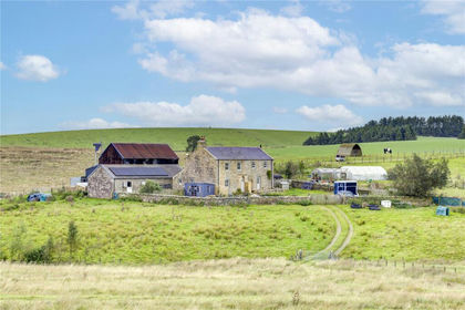
- Price
- £625,000
- Size
- 26.07 acres
High Tipalt Farm, Greenhead, Brampton, Northumberland, CA8, Greenhead, Northumberland CA8 England
Added on 22/09/2026Smallholding
- Price
- Guide Price£545,000
- Size
- 8 acres
Added on 24/09/2026Smallholding