Tysoe, Warwickshire
- Land size
- 1.09 acres
- Bedrooms
- 8
- Bathrooms
- 6
Key Features
- An impressive and beautifully proportioned country house, made for generous family living
- South-facing garden with swimming pool, pool house and far-reaching views across the Warwickshire countryside
- Self-contained two-bedroom apartment, ideal for staff, guests or independent family accommodation
- Private and elevated position on the edge of the sought-after village of Upper Tysoe
- Excellent access to Banbury, Stratford-upon-Avon and the Cotswolds, with the M40 approximately 10 miles away
- Banbury Station approximately 10 miles away, with direct trains to London Marylebone from 55 minutes
Description
Behind Sunrising House's handsome façade is a house built for a large family. Eight bedrooms, five bathrooms, two kitchens and a run of south-facing reception rooms give it the scale of a much bigger property. Yet the gardens draw in tightly around it, so the house feels private rather than exposed.
Why We Love Sunrising House - Sunrising House stands high on the southern edge of Upper Tysoe, looking out across open Warwickshire country towards Edge Hill. A tree-lined drive climbs to the rear of the house, where there is parking for several cars and a double garage. The village sits below; beyond it, nothing but fields.
Behind a handsome façade is a house built for a large family. Eight bedrooms, five bathrooms, two kitchens and a run of south-facing reception rooms give it the scale of a much bigger property, yet the gardens draw in tightly around it, so the house feels private rather than exposed.
The south-facing aspect is one that stays with you. Sunlight moves through the principal rooms from breakfast until evening, and every window on that side of the house frames the same long view over the Warwickshire landscape. In summer the French doors of the dining room open onto the terrace and the pool, and the garden becomes an extension of the house.
Upper Tysoe is a working village of ironstone cottages beneath Windmill Hill, ten miles from Banbury and its direct trains to Marylebone. Stratford-upon-Avon lies to the north, Chipping Campden and the Cotswolds to the west. It is a quiet position that is not an isolated one.
‘Sunlight moves through the principal rooms from breakfast until evening, and every window on the southern side frames the same long view across Warwickshire.’
The House
The drive arrives at the rear of the house, so the garden front is kept for the view. Rooms are generously proportioned and ceilings are high, and because the principal rooms run along the southern elevation, they are light from mid-morning onwards.
The reception rooms are arranged for entertaining on a considerable scale: a drawing room and a sitting room, both with garden views, and a dining room with French doors opening directly onto the terrace. This is described by the present owners as the summer dining room, and in practice it is where the household eats from May to September.
The kitchen is the working heart of the house and is centred on an electric AGA. A second kitchen runs off it, useful when the house is full or when catering for larger numbers, together with a utility and a cloakroom. [Boot room / larder / cellar to be confirmed.]
Bedrooms and bathrooms
There are eight bedrooms and five bathrooms in all, arranged over the first and second floors. The first-floor rooms are the largest, with the principal bedroom taking the south-west corner and the long view with it.
The second floor holds a further three bedrooms and two bathrooms, reached by a broad landing that is wide enough to work as a sitting area in its own right. It is a floor that suits children, teenagers or visiting guests, and it can be shut off from the rest of the house when it is not in use.
The Flat
Above the kitchen is a self-contained two-bedroom flat, well fitted and independently arranged with its own sitting room and kitchen. It has direct access to the main house and a separate door to the outside, which makes it equally suitable as housekeeper's accommodation, a nanny flat or a teenage suite. Let or occupied separately, it would not intrude on the main house.
Gardens and Grounds
The gardens extend to approximately 1.09 acres and are laid out on the southern side of the house, falling gently away towards the countryside beyond. Mature planting encloses them on three sides, so they are secluded despite the openness of the view.
They are arranged as a series of separate areas rather than a single lawn: a terrace off the dining room for eating outside, lawn below it, and established beds and specimen trees that screen the boundaries. The tree-lined drive and the parking area sit to the rear, away from the garden front.
The swimming pool lies within the garden, sheltered by planting and catching the sun for most of the day. [Pool dimensions, heating and any pool house to be confirmed.] Beyond the boundary the ground drops to farmland, and the view runs uninterrupted across the Warwickshire countryside.
Chapters Past - Sunrising takes its name from Sunrising Hill, where the Stratford road climbs the Edge Hill escarpment above the Vale of the Red Horse. The vale takes its name from the Red Horse of Tysoe, a hill figure once cut into the red clay nearby and first recorded in 1607. A photograph held by the Warwickshire County Record Office records it as a substantial country house on the hill by the 1910s.
In the years after the First World War the house is remembered locally as the home of Walter Samuel, later 2nd Viscount Bearsted. The son of Marcus Samuel, founder of Shell Transport and Trading, he had won the Military Cross on the Western Front and in 1921 succeeded his father as chairman of Shell. He was also one of the most discerning art collectors of his generation. Sunrising was then a working country household, with its own stables and grooms.
In 1927, the year he inherited his father's title, Lord Bearsted bought Upton House, a few miles along the same ridge. There Lady Bearsted transformed the gardens in the early 1930s, and he assembled the collection of paintings that he gave, together with the house, to the National Trust in 1948. Upton is now one of the Trust's best-known houses; Sunrising, where the Bearsted story in Warwickshire began, remains a private home.
Living In Warwickshire - Upper Tysoe is the highest of the three Tysoe villages, built of the local ironstone beneath Windmill Hill and set in the rolling country below Edge Hill. The village retains its church, village hall and public house, and the surrounding lanes are well used by walkers and riders.
Stratford-upon-Avon provides theatre, restaurants and everyday shopping; Banbury offers a mainline station and access to the M40. The Cotswolds begin a short drive west, with Chipping Campden and Broadway within easy reach, and there is good walking directly from the village along the Centenary Way and the Edge Hill escarpment.
Schools
The area is well served at every level, with Bloxham, Tudor Hall and Sibford close by, Winchester House at Brackley, Warwick School and King's High Warwick to the north, and Rugby and Stowe within reach.
Map Location
Property details
- Tenure
- Freehold
- Council Tax Band
- H
- Date Posted
- 2026-10-15
Market Value Analysis
Compared with 1,032 Homes with Land listings in West Midlands (1+ acres).
Energy Performance Certificate
Energy Efficiency Rating
Based on UK Energy Performance Certificate standards (EU Directive 2002/91/EC)
Running costs are one side. Planning activity, flood history and ground risks for this location are in the full report.
Utilities & Restrictions
Utilities
- Electricity
- Ask Agent
- Water
- Ask Agent
- Heating
- Ask Agent
- Broadband
- Ask Agent
- Sewerage
- Ask Agent
Rights & Restrictions
- Public Rights of Way
- Ask Agent
- Private Rights of Way
- Ask Agent
- Listed Property
- Ask Agent
- Restrictions
- Ask Agent
Listed status, conservation areas and planning constraints for this location are in the full report.
Property Features
- Accessibility
- Ask Agent
- Parking
- Parking Available
- Garden
- Garden
Beyond the particulars: planning activity, flood history, heritage and ground risks, checked for this exact spot.
Connectivity
Broadband
Fastest speed available at this postcode
950 Mbps
Gigabit full fibre · available to 40% of premises
Suitable for
- 4K streaming on every screen
- Full-time home working
- Online gaming & big downloads
Mobile signal
Predicted 4G and 5G signal; indoor signal depends on building materials.
Ofcom Connected Nations postcode-level predictions. Speeds and signal are modelled, not measured, and vary between addresses and providers.
Signal is the easy part. Planning activity, flood history and protected designations here are in the full report.
Nearest Schools
Primary
- Tysoe CofE Primary School1.5 milesOfsted: Good
- Ages
- 4 to 11
- Pupils
- 121
- Type
- Academy converter
- Faith
- Church of England
- Shenington Church of England Primary School1.9 milesOfsted: Good *
- Ages
- 4 to 11
- Pupils
- 84
- Type
- Voluntary aided school
- Faith
- Church of England
- Hornton Primary School2.1 milesOfsted: Good
- Ages
- 2 to 11
- Pupils
- 109
- Type
- Academy converter
- Kineton Church of England Primary School3.7 milesNo Ofsted rating
- Ages
- 4 to 11
- Pupils
- 208
- Type
- Academy converter
- Faith
- Church of England
- Wroxton Church of England Primary School4.1 milesNo Ofsted rating
- Ages
- 5 to 11
- Pupils
- 62
- Type
- Academy converter
- Faith
- Church of England
Secondary
- Kineton High School3.4 milesNo Ofsted rating
- Ages
- 11 to 18
- Pupils
- 1,082
- Type
- Academy converter
- North Oxfordshire Academy5.2 milesNo Ofsted rating
- Ages
- 11 to 19
- Pupils
- 1,004
- Type
- Academy sponsor led
- Futures Institute Banbury6.9 milesNo Ofsted rating
- Ages
- 14 to 18
- Pupils
- 116
- Type
- Studio schools
- Wykham Park6.9 milesNo Ofsted rating
- Ages
- 11 to 18
- Pupils
- 800
- Type
- Academy sponsor led
- Blessed George Napier Catholic School and Sixth Form7.1 milesOfsted: Good
- Ages
- 11 to 18
- Pupils
- 943
- Type
- Academy converter
- Faith
- Roman Catholic
* Latest graded judgement covers quality of education only; no overall grade was issued under the 2024-25 inspection framework.
Distances are straight-line from the advertised location. Source: the national school registers (DfE, Welsh Government, Scottish Government) and Ofsted.
Schools are just the start: sold prices nearby, planning activity and any flood history are in the full report.
Amenities
Supermarket
GP surgery
Pharmacy
Hospital
Straight-line distances from the advertised location. Sources: NHS records, Geolytix supermarket locations, OS Open Greenspace and the national trails registers.
The area stacks up? Now check the location itself: planning nearby, protected designations and past flooding.
Getting Around
Nearest station
Nearest bus stop
Typical drive times
Straight-line distances from the advertised location; drive times are typical free-flow times over OpenStreetMap road data, so allow more at peak. Public transport locations from DfT NaPTAN.
Easy to reach matters. So do planning activity, flood history and ground risks: all in the full report.
Flood Risk
Environment Agency open data, checked around the advertised map pin for the listed acreage. Long-term risk counts flood defences; the planning map's flood zones do not. The map pin for this listing marks the postcode area rather than the exact location, so these readings describe the surrounding area. Provided by LandSale, not the listing agent, and not part of the agent's particulars. Risk varies across a holding, so verify before committing.
Rivers and the sea
Planning map: Flood Zone 1.
Surface water
These bandings are the summary. Where this location sits on the flood maps, plus planning activity, heritage and ground risks, is in the full report.
Important notice: Information, maps and tags on this page are drawn from the advertising agent's marketing materials or generated automatically. LandSale has not verified them. Relying on these details is at your own risk, always carry out independent checks before committing to a purchase.
LandSale full disclaimer
Marketing information only - not formal particulars. The details on this website are provided for general guidance and do not constitute an offer or contract. Neither LandSale nor the advertising estate/land agent accepts responsibility for any inaccuracy.
1. Source of information
- Listing content: Core description, asking price, tenure, measurements, photographs and planning history originate from the marketing materials of the advertising estate or land agent. LandSale does not author this content and cannot guarantee its accuracy.
- Automated tags & categorisation: Property type, land-use class, acreage bands and similar labels may be applied by machine-learning models. They are intended as a helpful guide only and may not reflect the property's legal status or permitted use.
- Third-party & enriched data layers: Maps, boundary outlines, planning designations, soil reports, broadband coverage and other environmental or location-based insights are licensed from external suppliers. Such data are supplied “as is", may be incomplete or out of date and are subject to change without notice.
2. Verification required
Prospective purchasers must verify critical matters, including but not limited to planning permission, title boundaries, public rights of way, environmental constraints, acreage, services, access and VAT status, through their own inspections, specialist surveys, legal advisers and the selling agent before relying on the information or entering into any contract.
3. No warranty or liability
LandSale gives no warranty, express or implied, as to the accuracy, completeness or fitness for any particular purpose of the information displayed. LandSale shall not be liable for any loss, damage, cost or expense arising directly or indirectly from any use of or reliance on such information, save where liability may not be excluded by law.
4. Updates & feedback
If you believe any detail on this listing is inaccurate, please let us know. We will investigate and, where appropriate, update the listing or notify the agent.
© LandSale | Version 1.3 - August 2026
Listing agent
Blue Book, Covering the Country and London
Covering London
Similar properties for sale
- Price
- Guide Price£4,000,000
- Size
- 1.7 acres
Ford Lane, Langley, Stratford-Upon-Avon, Langley, Warwickshire CV37 England
Added on 07/07/2026Country Home
- Price
- Guide Price£4,000,000
- Size
- 9.17 acres
Lower Slaughter, Gloucestershire, Lower Slaughter, Gloucestershire GL54 England
Added on 25/05/2026Country Home
- Price
- Guide Price£4,000,000
- Size
- 5 acres
Wood Stanway, Cheltenham, Gloucestershire, GL54, Stanway, Gloucestershire GL54 England
Added on 11/09/2026Country Home
- Price
- Guide Price£3,500,000
- Size
- 19 acres
Park Lane, Sevenhampton, Cheltenham, Cotswold, GL54, Sevenhampton, Gloucestershire GL54 England
Added on 25/05/2026Country Home
- Price
- Guide Price£3,575,000
- Size
- 17.73 acres
Nr Bibury, Gloucestershire, Bibury, Gloucestershire GL7 England
Added on 09/09/2026Country Home
- Price
- Guide Price£3,500,000
- Size
- 11.3 acres
Buckland, Faringdon, Oxfordshire, SN7, Buckland, Oxfordshire SN7 England
Added on 10/10/2026Country Home
- Price
- Guide Price£3,500,000
- Size
- 34 acres
Longdon, Worcestershire, GL20, Longdon, Worcestershire GL20 England
Added on 03/09/2026Country Estate
- Price
- Guide Price£5,250,000
- Size
- 10 acres
Newington, Wallingford, OX10, Drayton St. Leonard, Oxfordshire OX10 England
Added on 21/03/2026Country Home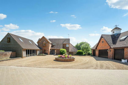
- Price
- £3,750,000
- Size
- 29 acres
Great Brickhill Road, Soulbury, Buckinghamshire, Soulbury, Buckinghamshire LU7 England
Added on 28/01/2026Equestrian property