Panttirion, St Dogmaels, Pembrokeshire, SA43
- Land size
- 250 acres
- Bedrooms
- 5
- Bathrooms
- 2
Key Features
- A chance to acquire a prime agricultural holding in a highly desirable location that has not been on the market for almost half a century
- Approximately 250 acre farm (edged red) of productive grassland with a further c80 acres available by separate negotiation (edged blue)
- Approximately an additional 80 acres available by separate negotiation
- Productive grassland from fields well suited to commercial silage production and grazing. Improved soil fertility from enhanced composted manures
- Elegant five bedroom period farmhouse of approximately 3329 sq ft. Approaching 40,000 sq ft of modern and traditional farm buildings
- Practical infrastructure including three phase electricity, private and mains water supplies and good HGV access to the farm from the A487
- Although used in recent times as a sheep and beef farm, various items of fixed equipment are available for purchase including redundant parlour
Description
Panttirion Farm
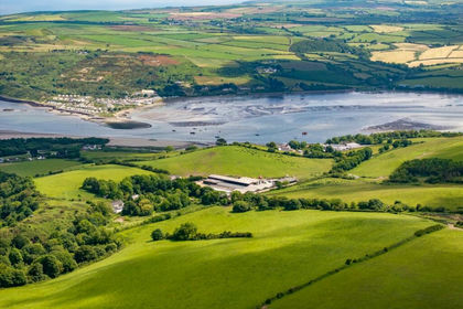
Panttirion Farm is a substantial coastal farmholding set in an outstanding position above Cardigan Bay, approximately three miles South of Cardigan. Extending to approximately 250 acres (including Farmstead) of productive grassland, with a further approximate 80 acres available separately, the farm lies in a single easily managed block of free draining loam and enjoys an elevated yet sheltered setting between Cardigan and Moylegrove. A private tarmac drive leads through the farmstead to the traditional stone farmhouse and extensive range of modern and traditional agricultural buildings, forming a well organised and highly functional centre to the holding. The current owners have occupied Panttirion Farm for almost 50 years, initially with a dairy herd but more recently with beef cattle, sheep and some cropping.
The Land
The holding extends to approximately 250 acres of productive grassland (net of farmstead 243 acres) with a further 80.06 acres available by separate negotiation. The land forms a substantial coastal block of pastureland rising between 400 and 600 feet above sea level. The land lies in a single, coherent ring fenced block, with fields arranged in generous workable parcels that are easily accessed from the central farmstead and internal tracks.
The majority of the land is classified as Grade 3b, with smaller proportions of Grade 4 and Grade 3a and is underpinned by freely draining loamy soils that support strong grass growth and reliable forage production. The farm includes pockets of woodland, traditional boundaries and small areas of non agricultural ground offering scope for environmental or habitat based options under future agricultural support schemes. Several parcels benefit from natural water sources and established trough networks, and the land has historically supported a high output dairy system. Although not certified, the land has been managed organically in recent years. Public footpaths cross parts of the holding, PP87/19 and PP87/20. There are also three small pockets of designated Ancient Woodland along the Eastern boundary of the primary land holding.
House
The farmhouse at Panttirion is a distinguished period home of considerable character, offering family accommodation that reflects the scale of the wider holding. Arranged over two floors and extending to approximately 3,329 sq ft, the house combines traditional stone construction and original features with practical features including oil fired central heating, wood burning stoves and well proportioned living spaces.
The ground floor centres around a generous hallway leading to two principal reception rooms, each with exposed beams and feature fireplaces together with a large kitchen/dayroom that opens directly to the garden. A utility room, separate WC and access to a substantial cellar provide further functionality. The first floor offers five bedrooms, including a study/bedroom on the half landing, and two bathrooms, creating a flexible layout suited to family living or multi generational use.
Opposite the farmhouse lies an historic walled garden which contains both matured trees and replanted fruit trees, giving a reliable supply of cooking and dessert apples, pears and plums.
Adjacent to the main house is the former farm office and flat arranged over two floors. The flat has been removed from the Council Tax following confirmation of structural issues. It remains in a dilapidated condition but historically provided a ground floor shower room, kitchen, living room and bedroom and on the first floor a large office area with separate w/c.
Services
The Farm benefits from 440 volts three phase electricity supply. The farmhouse takes a standard 240 volt connection from this supply. Water is supplied via a borehole and a mains supply. Foul drainage is provided by a private septic tank and high speed connectivity is available through Starlink satellite broadband to the farmhouse. The farmhouse benefits from oil fired central heating.
Location
Panttirion occupies a striking coastal position above Cardigan Bay, lying just west of St Dogmaels and within easy reach of Cardigan. Approached from Cardigan, follow the A487 over the river and turn immediately right towards St Dogmaels. Continue through the village and take the signed road to Moylegrove, climbing steadily out of the valley. After approximately two and a half miles, the entrance to Panttirion Farm appears on the right, marked by a tarmac drive and cattle grid.
Tenure and Possession
Offered for sale by private treaty as a whole or in two Lots. The main farm lot will be sold first.
Sporting, Timber and Mineral Rights
Insofar as they are owned, these are included in the sale.
Local Authority
Pembrokeshire County Council, Council Tax Band: G. Pembrokeshire Coast National Park
Rural Payments Wales
The land has been registered with Rural Payments Wales and the land parcels will be transferred to a new owner on completion. The vendor reserves full rights to the 2026 Basic Payment Scheme. 1.28 ha of native broadleaf woodland was created in March 2025 as a wildlife corridor along the brook in the cwm. This was under the Capital works 'Small Woodland Creation Scheme'. This area benefits from a small annual maintenance payment for a number of years to come.
Easements, Wayleaves and Rights of Way
The property is sold subject to and with the benefit of all rights, including rights of way, whether public or private, light, support, drainage, water, and electricity supplies and any other rights and obligations, easements and proposed wayleaves for masts, pylons, stays, cables, drains and water, gas and other pipes, whether referred to in the Conditions of Sale or not. Public footpaths PP87/19 and PP87/20 cross parts of the holding. Please check with the Highways Department at the local County Council for the exact location of public footpaths/ bridleways.
Viewings
Viewing is strictly by prior appointment with the sole selling agent. Given the potential hazards of a farm we would ask you to be as vigilant as possible for your own safety when making your inspection, particularly around the farm outbuildings, machinery, livestock and old slurry pit. The property and farm equipment are protected by CCTV and thermal detection alarm systems installed and maintained by specialist security contractors.
Ingoing Valuation
If applicable, in addition to the purchase price the Purchaser(s) will take over and pay for all growing crops, cultivations and stocks and stores (e.g., feeding stuffs, hay, straw, fuels, oils etc) at valuation. Payment is to be made upon completion at the figure assessed by the Vendors’ value based upon CAAV rates or contractors’ rates where applicable and invoiced costs of stocks, stores, seed, fertiliser and sprays applied.
Value Added Tax (VAT)
Should the sale of the property or any right attached to it be deemed a chargeable supply for VAT purposes, such tax will be payable by the purchaser in addition to the sale price.
Farm Buildings
Panttirion Farm benefits from an extensive range of modern and traditional dairy buildings forming a well organised and highly functional farmstead. The principal structures include:
1. Cattle Barn 46.0m x 22.5m (approximately 11,200 sq ft) steel and concrete building with cubicles for 150 cows, two internal feed passages and a surrounding concrete apron
2. 8 Bay Tractor Shed/workshop (former Grain Store) 37.0m x 10.37m (approximately 4,130 sq ft) with 4 calving pens and a bull pen alongside
3. 10:20 Gascoigne Milking Parlour (not in use and in need of refurbishment) 16.0m x 14.0m (approximately 2,411 sq ft)
Bulk Tank Room with Japy Tech 10,000 litre milk tank
4. Cattle Barn 2 16.6m x 14.85m (approximately 2,700 sq ft) steel framed building, open plan for stock or calving with an outside concrete yard with water trough.
5. Traditional Stone Ranges Multiple stone buildings providing calf housing, loose boxes, kennels, bull pens, pig sties, workshop space and general storage.
6. Dutch Barns
o Six bay corrugated iron sheep shed 26.8m x 19m with lean-to 5.0m x 19.0m (approximately 6,505 sq ft).
o Metal Three-Bay Fodder Shed 10.32m x 13.30m (approximately 1478 sq ft).
7. Youngstock & Calf Buildings Brick and stone buildings arranged around a square courtyard, providing sheltered accommodation for youngstock and calf rearing.
Silage & Slurry Infrastructure
• Silage Pit Heavy duty pit constructed of railway sleepers and RSJs with a concrete base, suitable for the storage of bales only.
• Slurry Compound of earth banks and stone floor, of circa 1976 construction.
Map Location
Property details
- Tenure
- Freehold
- Council Tax Band
- G
- Date Posted
- 2026-10-10
Market Value Analysis
Compared with 16 Farms & Smallholdings listings in Wales (250+ acres).
Energy Performance Certificate
Energy Efficiency Rating
Based on UK Energy Performance Certificate standards (EU Directive 2002/91/EC)
Running costs are one side. Planning activity, flood history and ground risks for this location are in the full report.
Utilities & Restrictions
Utilities
- Electricity
- Mains
- Water
- Mains
- Heating
- Ask Agent
- Broadband
- Ask Agent
- Sewerage
- Septic Tank / Private
Rights & Restrictions
- Public Rights of Way
- Ask Agent
- Private Rights of Way
- Ask Agent
- Listed Property
- Ask Agent
- Restrictions
- Ask Agent
Listed status, conservation areas and planning constraints for this location are in the full report.
Property Features
- Accessibility
- Ask Agent
- Parking
- Parking Available
- Garden
- Garden
Beyond the particulars: planning activity, flood history, heritage and ground risks, checked for this exact spot.
Connectivity
Broadband
Fastest speed available at this postcode
1.8 Gbps
Gigabit full fibre
Suitable for
- 4K streaming on every screen
- Full-time home working
- Online gaming & big downloads
Mobile signal
Predicted 4G and 5G signal; indoor signal depends on building materials.
Ofcom Connected Nations postcode-level predictions. Speeds and signal are modelled, not measured, and vary between addresses and providers.
Signal is the easy part. Planning activity, flood history and protected designations here are in the full report.
Nearest Schools
Primary
- Ysgol Llandudoch1.7 miles
- Pupils
- 77
- Type
- Nursery, Infants & Juniors
- Language
- Welsh medium school / provision (including transitional)
- Ysgol Gynradd Aberteifi2.7 miles
- Pupils
- 379
- Type
- Nursery, Infants & Juniors
- Language
- Welsh medium school / provision (including transitional)
- Cilgerran Church in Wales VC School4.2 miles
- Pupils
- 114
- Type
- Nursery, Infants & Juniors
- Language
- Welsh medium school / provision (including transitional)
- Ysgol Gymunedol Llechryd5.1 miles
- Pupils
- 54
- Type
- Infants & Juniors
- Language
- Welsh medium school / provision (including transitional)
- Ysgol Gynradd Gymunedol Eglwyswrw5.3 miles
- Pupils
- 90
- Type
- Infants & Juniors
- Language
- Welsh medium school / provision (including transitional)
Secondary
- Ysgol Uwchradd Aberteifi2.7 miles
- Pupils
- 614
- Type
- Secondary (ages 11-19)
- Language
- Welsh medium school / provision (including transitional)
- Ysgol Bro Preseli8.8 miles
- Pupils
- 932
- Type
- Middle (ages 3-19)
- Language
- Welsh medium school / provision (including transitional)
- Ysgol Gyfun Emlyn11 miles
- Pupils
- 502
- Type
- Secondary (ages 11-19)
- Language
- Dual language school / provision (Welsh and English) (including transitional)
- Ysgol Bro Gwaun13 miles
- Pupils
- 574
- Type
- Secondary (ages 11-16)
- Language
- Dual language school / provision (Welsh and English) (including transitional)
- Ysgol Bro Teifi17 miles
- Pupils
- 861
- Type
- Middle (ages 3-19)
- Language
- Welsh medium school / provision (including transitional)
Distances are straight-line from the advertised location. Source: the national school registers (DfE, Welsh Government, Scottish Government) and Ofsted.
Schools are just the start: sold prices nearby, planning activity and any flood history are in the full report.
Amenities
Supermarket
GP surgery
Pharmacy
Walking trail
Straight-line distances from the advertised location. Sources: NHS records, Geolytix supermarket locations, OS Open Greenspace and the national trails registers.
The area stacks up? Now check the location itself: planning nearby, protected designations and past flooding.
Getting Around
Nearest station
Nearest bus stop
Typical drive times
Straight-line distances from the advertised location; drive times are typical free-flow times over OpenStreetMap road data, so allow more at peak. Public transport locations from DfT NaPTAN.
Easy to reach matters. So do planning activity, flood history and ground risks: all in the full report.
Flood Risk
Natural Resources Wales open data, checked around the advertised map pin for the listed acreage. Long-term risk counts flood defences; the planning map's flood zones do not. Provided by LandSale, not the listing agent, and not part of the agent's particulars. Risk varies across a holding, so verify before committing.
Rivers and the sea
Planning map: Flood Zone 1.
Surface water
These bandings are the summary. Where this location sits on the flood maps, plus planning activity, heritage and ground risks, is in the full report.
Important notice: Information, maps and tags on this page are drawn from the advertising agent's marketing materials or generated automatically. LandSale has not verified them. Relying on these details is at your own risk, always carry out independent checks before committing to a purchase.
LandSale full disclaimer
Marketing information only - not formal particulars. The details on this website are provided for general guidance and do not constitute an offer or contract. Neither LandSale nor the advertising estate/land agent accepts responsibility for any inaccuracy.
1. Source of information
- Listing content: Core description, asking price, tenure, measurements, photographs and planning history originate from the marketing materials of the advertising estate or land agent. LandSale does not author this content and cannot guarantee its accuracy.
- Automated tags & categorisation: Property type, land-use class, acreage bands and similar labels may be applied by machine-learning models. They are intended as a helpful guide only and may not reflect the property's legal status or permitted use.
- Third-party & enriched data layers: Maps, boundary outlines, planning designations, soil reports, broadband coverage and other environmental or location-based insights are licensed from external suppliers. Such data are supplied “as is", may be incomplete or out of date and are subject to change without notice.
2. Verification required
Prospective purchasers must verify critical matters, including but not limited to planning permission, title boundaries, public rights of way, environmental constraints, acreage, services, access and VAT status, through their own inspections, specialist surveys, legal advisers and the selling agent before relying on the information or entering into any contract.
3. No warranty or liability
LandSale gives no warranty, express or implied, as to the accuracy, completeness or fitness for any particular purpose of the information displayed. LandSale shall not be liable for any loss, damage, cost or expense arising directly or indirectly from any use of or reliance on such information, save where liability may not be excluded by law.
4. Updates & feedback
If you believe any detail on this listing is inaccurate, please let us know. We will investigate and, where appropriate, update the listing or notify the agent.
© LandSale | Version 1.3 - August 2026
Listing agent
Nock Deighton, Agricultural LLP
Old Smithfield, 34-35 Whitburn Street Bridgnorth WV16 4QN
Contact Nock Deighton, Agricultural LLP
Old Smithfield, 34-35 Whitburn Street Bridgnorth WV16 4QN
View agent profileSimilar properties for sale
- Price
- Guide Price£3,000,000
- Size
- 220 acres
St Dogmaels, Cardigan, SA43, St. Dogmaels, Pembrokeshire SA43 Wales
Added on 08/02/2026Dairy Farm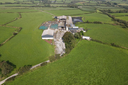
- Price
- Offers in Region of£2,350,000
- Size
- 194 acres
Talog, Carmarthen, SA33, Carmarthen, Carmarthenshire SA33 Wales
Added on 29/01/2026Dairy Farm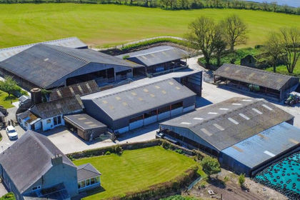
- Price
- £3,300,000
- Size
- 333.36 acres
Lots 2 & 3, Llandeilo Abercowin, Carmarthen, Llansteffan, Carmarthenshire SA33 Wales
Added on 10/06/2026Dairy Farm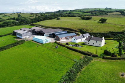
- Price
- Offers in Region of£2,200,000
- Size
- 238.57 acres
Sylen Road, Pontyberem, SA15, Pontyberem, Carmarthenshire SA15 Wales
Added on 03/04/2026Livestock Farm