Bromesberrow, Ledbury, Gloucestershire, HR8
- Land size
- 1.35 acres
- Bedrooms
- 3
- Bathrooms
- 1
Key Features
- 1 Bathroom
- 3 Bedrooms
- 2 Reception Rooms
- Cottage
- Detached
- Garden
- Land/Paddock
- Period
- 1022 Approx Sq Ft
- Freehold
Description
An attractive period cottage in a beautiful location, set within 1.35 acres.
collapsed.culling.collected
Summary of Features
* 3 bedrooms, 1 bathroom, period cottage (1,022 sq ft) * 2 receptions and spacious fitted kitchen * Will benefit from some modernisation, particularly the windows * Traditional outbuildings with scope * Adjacent orchard with grazing of 1.20 Acres, 1.35 Acres in total * Beautiful setting at Whiteleaved Oak
Location
* Mileages: Ledbury 6 miles, Malvern 10 miles, Tewkesbury & Upton-upon-Severn 10½ miles, Gloucester 15 miles, Hereford, Worcester & Cheltenham within 20 miles, Birmingham 54 miles * Road: M50 (Jct 2) 3 miles, M5 (Jct 8) 14 miles * Railway: Ledbury, Malvern, Ashchurch (Tewkesbury) * Airport: Birmingham & Bristol 58 miles
Situation
This cottage is situated in the sought after and rarely available rural location of Whiteleaved Oak, which is nestled towards the southern edge of the beautiful Malvern Hills. This area is renowned for its scenic and unspoilt rural appeal and is surrounded by rolling woodland and farmland. Whilst rurally situated, the property is easily accessible and benefits from good road and rail links to the larger commercial centres of Gloucester, Cheltenham, Worcester and Birmingham.
The Cottage
* This attractive cottage has been in long term ownership as a rental property and has not been seen on the market in many decades, this a rare offering for the location. * Believed to originate from the early 17th century, this property had a Victorian makeover which defines its current form and benefits from a very peaceful setting on the Western side of the Malvern Hills. * Accommodation comprises two double and a single bedroom, with a modest family bathroom to the first floor.
The Cottage (contiued)
* On the ground floor there are two reception rooms, both with woodburning stoves, and a spacious fitted kitchen. A rear entrance, with WC leads to the kitchen. The front door is south facing and is accessed across the lawned garden * This is very much a country cottage with ceiling heights to match. Whilst in sound condition, it will certainly benefit from some modernisation. In particular, the windows are single glazed and some need remedial attention.
The Outside
* Located adjacent to a small country lane, parking is available in bays by the road and a parking lot by the outbuildings, which are on the opposite side of the lane. * The two outbuildings are of brick and stone construction, mostly under clay tile roofing and provide some 678 sq ft storage area with potential for garaging. * The sloping garden is enclosed and mostly to the South side of the cottage, a smaller level area to the north side has separate pedestrian access off the lane, with secured boarded roadside fencing.
The Outside (continued)
* A small utility/storeroom is attached to the east end of the cottage and has external access. * Below the garden is a rambling orchard of about 1.20 acres, this provides grazing and lots of outside space for a variety of uses. * Access to the orchard is via a right of way over a separate Estate owned track. This access may be used for 12 months from date of completion but within this period the new owner must install a new and independent access off the public road. Suitable permissions will need to be obtained. * In all, there are about 1.35 acres of land offered with this property.
For Sale by Informal tender
The tender process is explained below. It is intended to be clear and straightforward; however, if you have any queries, please contact the Agent at your earliest opportunity. * The legal tender pack should be available from the Vendors solicitor by 30th October on request (supplied at a charge) and will also be available to view at the Grant & Co office in Ledbury, by appointment. * Offers for this property must be submitted by 27 November 2027. Please note that the Vendor reserves the right to agree a sale ahead of the tender deadline, should they receive a suitably compelling proposal.
Informal Tender
This property is being offered for sale by Informal Tender under the following terms. All participants will be deemed to have accepted these terms by proceeding with an offer. 1. Offers must be submitted in writing by no later than 12 noon on 27th November 2026. Offers must be clearly stated in writing to the Estate Agent, by email or post, not related to any other bids and addressed FAO: Tom Grant, , Bank Chambers, 24 High Street, Ledbury, HR8 1DS.
Informal Tender (continued)
2. Bidders must detail and provide evidence of their identity and proposed funding, including the source of their funds. 3. Bidders should provide their solicitor’s contact details; all payments will need to be made via their solicitor to the vendors solicitor. 4. The legal Tender Pack will be available to order from 30th October, directly from the Vendors solicitor (supply cost tbc). The Vendor’s solicitor is Loxley Solicitors Ltd, Langford Mill, Kingswood, Wotton Under Edge, GL12 8RL. FAO Ellie Sanders, Ellie.
Informal Tender (continued)
A copy of the tender pack will be available to view at the office of Grant & Co in Ledbury, by appointment only. 5. The Vendor is not obliged to accept the highest or any offer and may choose the most suitable Bidder (in their opinion). 6. The Vendor reserves the right to agree a sale ahead of the Tender Deadline, should they receive a suitably compelling proposal.
Informal Tender (continued)
7. The Vendor will aim to make a decision within 5 working days of the Tender Deadline. 8. The successful Bidder will be required to transfer their deposit (via their solicitor) and exchange contracts within 10 working days of being notified. 9. Completion by agreement but anticipated within 4 weeks of contract exchange. Any additional enquiries should initially be addressed to Tom Grant at Grant & Co Estate Agents.
Material Information
Services
Mains water and electricity, private drainage (septic tank), oil-fired central heating (modern boiler/tank) and two wood burning stoves.
Broadband
Standard BT provision (up to 16 Mbps d/l), full fibre is now available for connection.
Mobile Phone Signal
Good with mainstream providers.
Local Authority
Forest of Dean District Council: .
Council Tax
Band “B” (£1,900 for 2026/27).
Tenure
Freehold.
Construction
Red brick under a clay tile roof.
Building Survey
A building survey will be available by the end of October.
Listing
This property is not Listed.
Planning Permission
No current or outstanding permissions.
EPC
Rated “E” (potential for “A”).
Flood Risk
There is no known flood risk to this property.
Access
Direct from a public road.
Public Access
There are no Rights of Way or Public Footpaths over this property.
Orchard Access
By right of way granted for 12 months only by the Vendor. The buyer must install their own access within this 12 month period.
Covenants
Any development that requires planning permission must be approved in writing by the Vendor, prior to any work starting.
National Landscape
The property is within the Malvern Hills National Landscape (formerly an AONB).
Conservation Area
The property is not within a Conservation Area.
Buyer's Purchase Fee
Please note that buyers are required to pay a Purchase Fee of £300 (inc. of VAT) to Grant & Co on offer acceptance, to process a new transaction.
General Information
Schools
* Primary: Eastnor, Castlemorton, Welland and Malvern. Further information is available at: and Secondary: Hanley Castle and Malvern. Further information: and Independent: Colwall, Malvern, Worcester, Gloucester and Cheltenham. Further information:
Local
The nearby hamlet of Bromesberrow has a church, primary school with nursery, a village hall and playing fields and there’s a useful village shop and cafe at Bromsberrow Heath. The thriving market towns of Ledbury and Malvern provide a good range of shopping (including Waitrose & M&S), educational and leisure facilities as well as two local hospitals. Further cultural & retail opportunities are readily accessible in Worcester, Gloucester, Cheltenham, and Birmingham.
Recreational
Many fine walks can be accessed directly on the Hills from this property. The surrounding area offers a wide range of outdoor sports and activities, with the spectacular Malvern Hills, Castlemorton Common and Wye Valley on the doorstep. The Three Counties Showground at Malvern holds a wide variety of year-round events. Malvern is also home to a renowned Theatre and cinema. The market town of Ledbury hosts a well-known annual Poetry Festival and also has a popular Theatre. Nearby, Eastnor Castle is open to the public and hosts a wide variety of seasonal events from spring through to the autumn.
Directions - HR8 1SE
From M50 (Jct 2): Head south on the A417 Gloucester Road for 0.6 miles, take the first left and follow this road for 2 miles to the end at Camers Green. Turn sharp left, just before the junction with the B4208. Follow Back Lane for 0.5 mile to the end and turn right. Continue a further 0.5 mile and take the next left turn towards Whiteleaved Oak. Continue on this road for 0.70 miles; up the hill, round the left bend at the top, over the cattle grid and subsequently downhill towards Chase End. This cottage is the first on your right side after the cattlegrid, the outbuildings are immediately opposite on the left side of the lane, park by these.
What3Words
///collapsed.culling.collected
Viewings
By prior appointment only via Grant & Co Estate Agents on . Viewings commence from Monday afternoon, there is no availability on Saturday 10 October.
Agent's Notes
Grant & Co and their clients give notice that: 1. They have no authority to make or give any representations or warranties in relation to the property. 2. These particulars have been prepared in good faith to give a fair overall view of the property, do not form any part of an offer or contract and must not be relied upon as statements or representations of fact. 3. Any areas, measurements or distances are approximate. The text, photographs and plans are for guidance only and are not necessarily comprehensive. It should not be assumed that the property has all necessary planning, building regulation or other consents. The Agents have not tested any services, equipment or facilities. Purchasers must satisfy themselves by inspection or otherwise. Fixtures & Fittings Unless mentioned specifically all fixtures & fittings are excluded from the sale.
Map Location
Property details
- Tenure
- Freehold
- Council Tax Band
- TBC
- Date Posted
- 2026-10-10
Market Value Analysis
Compared with 1,628 Homes with Land listings in South West England (1+ acres).
Energy Performance Certificate
Energy Efficiency Rating
Based on UK Energy Performance Certificate standards (EU Directive 2002/91/EC)
Running costs are one side. Planning activity, flood history and ground risks for this location are in the full report.
Utilities & Restrictions
Utilities
- Electricity
- Ask Agent
- Water
- Ask Agent
- Heating
- Ask Agent
- Broadband
- Ask Agent
- Sewerage
- Ask Agent
Rights & Restrictions
- Public Rights of Way
- Ask Agent
- Private Rights of Way
- Ask Agent
- Listed Property
- Ask Agent
- Restrictions
- Ask Agent
Listed status, conservation areas and planning constraints for this location are in the full report.
Property Features
- Accessibility
- Ask Agent
- Parking
- Off-Street Parking
- Garden
- Garden
Beyond the particulars: planning activity, flood history, heritage and ground risks, checked for this exact spot.
Connectivity
Broadband
Fastest speed available at this postcode
61 Mbps
Superfast · available to 20% of premises
Suitable for
- HD streaming
- Video calls
- Web & social
Fixed wireless access may also be an option here.
Mobile signal
Predicted 4G and 5G signal; indoor signal depends on building materials.
Ofcom Connected Nations postcode-level predictions. Speeds and signal are modelled, not measured, and vary between addresses and providers.
Signal is the easy part. Planning activity, flood history and protected designations here are in the full report.
Nearest Schools
Primary
- Bromesberrow St Mary's Church of England Primary School1.1 milesNo Ofsted rating
- Ages
- 2 to 11
- Pupils
- 57
- Type
- Academy converter
- Faith
- Church of England
- Eastnor Parochial Primary School2 milesOfsted: Outstanding
- Ages
- 4 to 11
- Pupils
- 95
- Type
- Academy converter
- Faith
- Church of England
- Pendock CofE Primary School2.3 milesNo Ofsted rating
- Ages
- 3 to 11
- Pupils
- 58
- Type
- Voluntary controlled school
- Faith
- Church of England
- Castlemorton Church of England Primary School2.5 milesOfsted: Good
- Ages
- 2 to 11
- Pupils
- 92
- Type
- Academy converter
- Faith
- Church of England
- Redmarley Church of England Primary School2.6 milesOfsted: Good
- Ages
- 3 to 11
- Pupils
- 97
- Type
- Academy converter
- Faith
- Church of England
Secondary
- John Masefield High School3.1 milesNo Ofsted rating
- Ages
- 11 to 18
- Pupils
- 849
- Type
- Academy converter
- The Chase6.2 milesOfsted report card · Jan 2026
- Ages
- 11 to 18
- Pupils
- 1,449
- Type
- Academy converter
- Hanley Castle High School6.5 milesOfsted: Good
- Ages
- 11 to 18
- Pupils
- 1,142
- Type
- Academy converter
- Newent Community School and Sixth Form Centre6.7 milesNo Ofsted rating
- Ages
- 11 to 18
- Pupils
- 976
- Type
- Academy converter
- Dyson Perrins CofE Academy8.1 milesOfsted: Good
- Ages
- 11 to 16
- Pupils
- 592
- Type
- Academy converter
- Faith
- Church of England
Distances are straight-line from the advertised location. Source: the national school registers (DfE, Welsh Government, Scottish Government) and Ofsted.
Schools are just the start: sold prices nearby, planning activity and any flood history are in the full report.
Amenities
Supermarket
GP surgery
Pharmacy
Hospital
Straight-line distances from the advertised location. Sources: NHS records, Geolytix supermarket locations, OS Open Greenspace and the national trails registers.
The area stacks up? Now check the location itself: planning nearby, protected designations and past flooding.
Getting Around
Nearest station
Nearest bus stop
Typical drive times
Straight-line distances from the advertised location; drive times are typical free-flow times over OpenStreetMap road data, so allow more at peak. Public transport locations from DfT NaPTAN.
Easy to reach matters. So do planning activity, flood history and ground risks: all in the full report.
Flood Risk
Environment Agency open data, checked around the advertised map pin for the listed acreage. Long-term risk counts flood defences; the planning map's flood zones do not. Provided by LandSale, not the listing agent, and not part of the agent's particulars. Risk varies across a holding, so verify before committing.
Rivers and the sea
Planning map: Flood Zone 1.
Surface water
Not at the pin: mapped about 30 metres away.
These bandings are the summary. Where this location sits on the flood maps, plus planning activity, heritage and ground risks, is in the full report.
Important notice: Information, maps and tags on this page are drawn from the advertising agent's marketing materials or generated automatically. LandSale has not verified them. Relying on these details is at your own risk, always carry out independent checks before committing to a purchase.
LandSale full disclaimer
Marketing information only - not formal particulars. The details on this website are provided for general guidance and do not constitute an offer or contract. Neither LandSale nor the advertising estate/land agent accepts responsibility for any inaccuracy.
1. Source of information
- Listing content: Core description, asking price, tenure, measurements, photographs and planning history originate from the marketing materials of the advertising estate or land agent. LandSale does not author this content and cannot guarantee its accuracy.
- Automated tags & categorisation: Property type, land-use class, acreage bands and similar labels may be applied by machine-learning models. They are intended as a helpful guide only and may not reflect the property's legal status or permitted use.
- Third-party & enriched data layers: Maps, boundary outlines, planning designations, soil reports, broadband coverage and other environmental or location-based insights are licensed from external suppliers. Such data are supplied “as is", may be incomplete or out of date and are subject to change without notice.
2. Verification required
Prospective purchasers must verify critical matters, including but not limited to planning permission, title boundaries, public rights of way, environmental constraints, acreage, services, access and VAT status, through their own inspections, specialist surveys, legal advisers and the selling agent before relying on the information or entering into any contract.
3. No warranty or liability
LandSale gives no warranty, express or implied, as to the accuracy, completeness or fitness for any particular purpose of the information displayed. LandSale shall not be liable for any loss, damage, cost or expense arising directly or indirectly from any use of or reliance on such information, save where liability may not be excluded by law.
4. Updates & feedback
If you believe any detail on this listing is inaccurate, please let us know. We will investigate and, where appropriate, update the listing or notify the agent.
© LandSale | Version 1.3 - August 2026

Listing agent
Grant & Co, Ledbury
Bank Chambers, 24 High Street, Ledbury, Herefordshire, HR8 1DS
Contact Grant & Co, Ledbury
Bank Chambers, 24 High Street, Ledbury, Herefordshire, HR8 1DS
View agent profileSimilar properties for sale
- Price
- Guide Price£500,000
- Size
- 2 acres
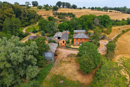
Redmarley, Gloucester, Gloucestershire, GL19, Redmarley D'Abitot, Gloucestershire GL19 England
Added on 24/08/2026Farmhouse
- Price
- Guide Price£465,000
- Size
- 0.31 acres
Added on 09/10/2026Residential
- Price
- Guide Price£350,000
Building Plots at Cold Green Farm, Bosbury, Herefordshire, County of HR8 England
Added on 31/07/2026Building Plot
- Price
- Offers Over£395,000
Aylton, Ledbury, Herefordshire, HR8, Aylton, Herefordshire, County of HR8 England
Added on 07/05/2026Barn Conversion
- Price
- Offers Over£400,000
Como Road, Great Malvern, Worcestershire, WR14, Malvern, Worcestershire WR14 England
Added on 29/01/2026Building Plot
- Price
- Guide Price£500,000
- Size
- 0.5 acres
Albert Park Road, Malvern, Worcestershire, WR14, Malvern, Worcestershire WR14 England
Added on 29/01/2026Building Plot
- Price
- £499,995
- Size
- 2.09 acres
Added on 25/05/2026House with Land
- Price
- £500,000
- Size
- 1.5 acres
Added on 25/08/2026House with Land
- Price
- Offers in Region of£400,000
- Size
- 1.44 acres
Stiffords Bridge, Cradley, Malvern, Cradley and Storridge, Herefordshire, County of WR13 England
Added on 29/01/2026House with Land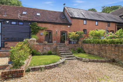
- Price
- Guide Price£349,950
Added on 24/06/2026Barn Conversion