Albert Park Road, Malvern, Worcestershire, WR14
- Land size
- 0.5 acres
Key Features
- Residential Building Plots With Full Consent For Two New Homes
- Prime Location Within Walking Distance Of Link Common And Great Malvern
- Architect-Designed Bespoke Houses Each With Over 2500 Sq Ft
- Lovely Setting In Nearly Half An Acre Of Woodland
- Both Homes Have Four Bedrooms With En-Suite Facilities
- Private Driveway And Parking
- Private Garden
Description
An All Too Rare Opportunity To Purchase A Pair Of Residential Building Plots With Full Planning Consent For The Construction Of Two Architect-Designed Bespoke Semi-Detached Four Bedroomed Homes Each With Accommodation Extending To Over 2500 Sq. Ft And Set In Nearly Half An Acre Of Woodland In A Prime Residential Location.
Location & Description
This unique site enjoys a fine setting in a highly regarded residential location off Albert Park Road which is only two minutes walk from the open expanse of Link Common and less than half a mile from the centre of Great Malvern, a cultural and historic town with a comprehensive range of amenities including shops and banks, Waitrose supermarket, a range of cafes and restaurants, the renowned theatre and cinema complex and the Splash leisure pool and gymnasium. It is even closer to the busy neighbourhood of Malvern Link where there are further amenities. Approximately a mile away is Malvern's main retail park where one can find a number of familiar High Street names.
For dog walkers and lovers of the outdoors not only is Link Common on the doorstep but the site sits at the foot of the Malvern Hills - an Area of Outstanding Natural Beauty - and offers easy access to a multitude of footpaths, offering stunning views on a clear day.
Educational facilities are second to none at both primary and secondary levels including Dyson Perrins and The Chase High Schools as well as Malvern College and Malvern St James private schools. Transport communications are excellent. The mainline railway station of Malvern Link is just a few minutes walk and offers direct trains to both London and Birmingham. Both the M5 and M50 motorways are easily accessible offering many commuting options.
Planning consent was granted by Malvern Hills District Council on 16th January 2025 for the construction of two new semi-detached dwellings (Application No. M/24/01067/FUL). These bespoke, high quality homes are designed to optimise natural light and space and will enjoy a quiet woodland setting extending to nearly half an acre. Each house is constructed over three floors.
Plans and Drawings
Full plans and drawings are available on Malvern Hills District Council's planning portal. These can be found by entering the reference number for the approved application: M/24/01067/FUL.
This permission also includes the construction of a small Eco Cabin within the grounds of the adjoining property, with separate access. It should be noted that this element of the consent is being retained by the current owners. It should be noted that this element of the consent is being retained by the current owners.
Computer Generated Images are for illustrative purposes only and should be treated as general guidance, refer to the Planning Approval for more information. Do not scale from drawings. Copyright Vivid Architects Ltd.
Unit 1.
2680 sq.ft (249 sq meteres) approximate gross internal area.
1. Four bedrooms all with en-suite
bathrooms. The large
master bedroom on the second floor
has a vaulted ceiling, dressing area
and a south west facing balcony.
2. Central open plan kitchen/dining
room with impressive double height
dining area.
3. Separate south west facing garden
room.
4. Large living room with feature bay
window and provision for log burner.
5. Generous snug/study.
6. Featured galleried staircase.
7. Utility/boot room.
8. Secure back garden with south west facing patio. Extensive front garden and shared driveway.
9. Garden shed with storage for three
bicycles.
10. Three private parking spaces.
Unit 2.
2540 sq.ft (236 sq. meters) approximate gross internal area.
1. Four bedroomed accommodation
three of which have en-suite
bathrooms. The large master
bedroom at second floor has a
vaulted ceiling, optional dressing
room and a south west facing
balcony.
2. Central open plan kitchen/dining
room.
3. South west facing garden room with vaulted ceiling, provision for log burner and mezzanine area.
4. Large living room with feature bay
window.
5. Feature galleried staircase.
6. Utility room.
7. Snug/study.
8. Secure rear garden with south west
facing patio. Extensive front garden
and shared driveway.
9. External secure store area for bins
and up to three bicycles.
10.Three private parking spaces.
Each house will be expected to have high levels of insulation to meet the exacting demands of new building regulations including space for water heating with air source heat pumps, EV charging points and electricity supported by photovoltaic panels.
Services
All mains services are available to the site (but not yet installed or connected).
Tenure
We are advised (subject to legal confirmation) that the site will be sold with full vacant possession.
General
Intending purchasers will be required to produce identification documentation and proof of funding in order to comply with The Money Laundering, Terrorist Financing and Transfer of Funds Regulations 2017. More information can be made available upon request.
John Goodwin FRICS has made every effort to ensure that measurements and particulars are accurate however prospective purchasers must satisfy themselves by inspection or otherwise as to the accuracy of the information provided. No information with regard to planning use, structural integrity, tenure, availability/operation, business rates, services or appliances has been formally verified and therefore prospective purchasers are requested to seek validation of all such matters prior to submitting a formal or informal intention to purchase the residential plots or enter into any contract.
Viewing
The site is visible from Albert Park Road. However potential buyers who are keen to explore the ground in more detail should register with the selling agents.
Directions
The plot can be located using either the postcode WR14 1HL or the following What3Words reference: ///trendy.pool.single.
From the selling agents office in Great Malvern proceed north along the A449 Worcester Road towards Malvern Link. Follow the road downhill through two sets of traffic lights with Link Common on your right hand side. After the second set of traffic lights, take the first left into Albert Park Road. The site can be seen on the left hand side after a short distance as indicated by the agent's sale boards.
Map Location
Property details
- Tenure
- Freehold
- Council Tax Band
- Ask Agent
- Date Posted
- 2026-01-29
Utilities & Restrictions
Utilities
- Electricity
- Ask Agent
- Water
- Ask Agent
- Heating
- Ask Agent
- Broadband
- Ask Agent
- Sewerage
- Ask Agent
Rights & Restrictions
- Public Rights of Way
- Ask Agent
- Private Rights of Way
- Ask Agent
- Listed Property
- Ask Agent
- Restrictions
- Ask Agent
Listed status, conservation areas and planning constraints for this location are in the full report.
Property Features
- Accessibility
- Ask Agent
- Parking
- Parking Available
- Garden
- Private Garden
Beyond the particulars: planning activity, flood history, heritage and ground risks, checked for this exact spot.
Connectivity
Broadband
Fastest speed available at this postcode
2.3 Gbps
Gigabit full fibre
Suitable for
- 4K streaming on every screen
- Full-time home working
- Online gaming & big downloads
Mobile signal
Predicted 4G and 5G signal; indoor signal depends on building materials.
Ofcom Connected Nations postcode-level predictions. Speeds and signal are modelled, not measured, and vary between addresses and providers.
Signal is the easy part. Planning activity, flood history and protected designations here are in the full report.
Nearest Schools
Primary
- St Joseph's Catholic Primary School503 metresOfsted: Good
- Ages
- 4 to 11
- Pupils
- 99
- Type
- Voluntary aided school
- Faith
- Roman Catholic
- Somers Park Primary School591 metresOfsted: Good
- Ages
- 2 to 11
- Pupils
- 582
- Type
- Academy converter
- St Matthias Church of England Primary School684 metresOfsted: Good
- Ages
- 3 to 11
- Pupils
- 162
- Type
- Academy converter
- Faith
- Church of England
- Grove Primary School701 metresOfsted: Inadequate
- Ages
- 3 to 11
- Pupils
- 103
- Type
- Academy sponsor led
- Northleigh CofE Primary School869 metresOfsted: Good
- Ages
- 2 to 11
- Pupils
- 202
- Type
- Academy sponsor led
- Faith
- Church of England
Secondary
- Dyson Perrins CofE Academy0.7 milesOfsted: Good
- Ages
- 11 to 16
- Pupils
- 592
- Type
- Academy converter
- Faith
- Church of England
- The Chase1.6 milesOfsted report card · Jan 2026
- Ages
- 11 to 18
- Pupils
- 1,449
- Type
- Academy converter
- Hanley Castle High School5 milesOfsted: Good
- Ages
- 11 to 18
- Pupils
- 1,142
- Type
- Academy converter
- Christopher Whitehead Language College5.8 milesNo Ofsted rating
- Ages
- 11 to 18
- Pupils
- 1,580
- Type
- Academy converter
- Blessed Edward Oldcorne Catholic College6.3 milesNo Ofsted rating
- Ages
- 11 to 16
- Pupils
- 1,036
- Type
- Voluntary aided school
- Faith
- Roman Catholic
Distances are straight-line from the advertised location. Source: the national school registers (DfE, Welsh Government, Scottish Government) and Ofsted.
Schools are just the start: sold prices nearby, planning activity and any flood history are in the full report.
Amenities
Supermarket
GP surgery
Pharmacy
Hospital
Green space
Straight-line distances from the advertised location. Sources: NHS records, Geolytix supermarket locations, OS Open Greenspace and the national trails registers.
The area stacks up? Now check the location itself: planning nearby, protected designations and past flooding.
Getting Around
Nearest station
Nearest bus stop
Typical drive times
Straight-line distances from the advertised location; drive times are typical free-flow times over OpenStreetMap road data, so allow more at peak. Public transport locations from DfT NaPTAN.
Easy to reach matters. So do planning activity, flood history and ground risks: all in the full report.
Flood Risk
Environment Agency open data, checked around the advertised map pin for the listed acreage. Long-term risk counts flood defences; the planning map's flood zones do not. Provided by LandSale, not the listing agent, and not part of the agent's particulars. Risk varies across a holding, so verify before committing.
Rivers and the sea
Planning map: Flood Zone 1.
Surface water
These bandings are the summary. Where this location sits on the flood maps, plus planning activity, heritage and ground risks, is in the full report.
Important notice: Information, maps and tags on this page are drawn from the advertising agent's marketing materials or generated automatically. LandSale has not verified them. Relying on these details is at your own risk, always carry out independent checks before committing to a purchase.
LandSale full disclaimer
Marketing information only - not formal particulars. The details on this website are provided for general guidance and do not constitute an offer or contract. Neither LandSale nor the advertising estate/land agent accepts responsibility for any inaccuracy.
1. Source of information
- Listing content: Core description, asking price, tenure, measurements, photographs and planning history originate from the marketing materials of the advertising estate or land agent. LandSale does not author this content and cannot guarantee its accuracy.
- Automated tags & categorisation: Property type, land-use class, acreage bands and similar labels may be applied by machine-learning models. They are intended as a helpful guide only and may not reflect the property's legal status or permitted use.
- Third-party & enriched data layers: Maps, boundary outlines, planning designations, soil reports, broadband coverage and other environmental or location-based insights are licensed from external suppliers. Such data are supplied “as is", may be incomplete or out of date and are subject to change without notice.
2. Verification required
Prospective purchasers must verify critical matters, including but not limited to planning permission, title boundaries, public rights of way, environmental constraints, acreage, services, access and VAT status, through their own inspections, specialist surveys, legal advisers and the selling agent before relying on the information or entering into any contract.
3. No warranty or liability
LandSale gives no warranty, express or implied, as to the accuracy, completeness or fitness for any particular purpose of the information displayed. LandSale shall not be liable for any loss, damage, cost or expense arising directly or indirectly from any use of or reliance on such information, save where liability may not be excluded by law.
4. Updates & feedback
If you believe any detail on this listing is inaccurate, please let us know. We will investigate and, where appropriate, update the listing or notify the agent.
© LandSale | Version 1.3 - August 2026
Listing agent
John Goodwin FRICS, Malvern
13, Worcester Road, Malvern, WR14 4QY
Similar properties for sale

- Price
- Offers Over£400,000
Como Road, Great Malvern, Worcestershire, WR14, Malvern, Worcestershire WR14 England
Added on 29/01/2026Building Plot
- Price
- Guide Price£450,000
Tibberton Road, Great Malvern, Worcestershire, WR14, Malvern, Worcestershire WR14 England
Added on 14/10/2026Building Plot
- Price
- From£595,000
Mistletoe Way, Worcester, WR6, Martley, Worcestershire WR6 England
Added on 29/01/2026Self Build Plot
- Price
- Guide Price£470,000
Added on 29/01/2026Building Plot
- Price
- Guide Price£600,000
Abbey View Road, Wyre Piddle, Pershore, Wyre Piddle, Worcestershire WR10 England
Added on 19/03/2026Development Land
- Price
- £500,000
- Size
- 1.7 acres
Sapey Common, Upper Sapey, WR6, Upper Sapey, Herefordshire, County of WR6 England
Added on 28/01/2026Building Plot Added on 11/03/2026Development Land
- Price
- Offers in Region of£450,000
- Size
- 0.72 acres
Sutton St. Nicholas, Hereford, Sutton, Herefordshire, County of HR1 England
Added on 24/06/2026Building Plot
- Price
- Offers Over£450,000
Abbots Morton, Worcester, Abbots Morton, Worcestershire WR7 England
Added on 16/08/2026Conversion Land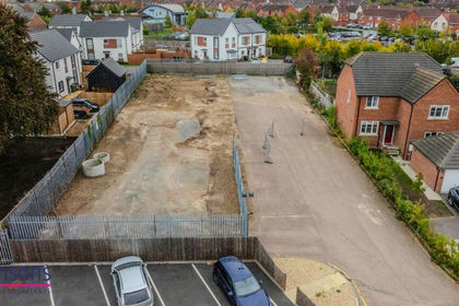
- Price
- Offers Over£550,000
Kings Road, Evesham, WR11, Evesham, Worcestershire WR11 England
Added on 29/01/2026Development Land