
Wembworthy, Chulmleigh, EX18
- Land size
- 66.01 acres
- Bedrooms
- 5
- Bathrooms
- 2
Key Features
- Superb residential smallholding
- Outstanding rural position
- Character five bedroomed farmhouse
- Courtyard of traditional farm buildings with alternative potentil (stp)
- Further modern farm buildings
- Productive pasture land
- In all about 66.01 Acres
Description
An outstanding Residential Smallholding enjoying a superb rural position with an attractive farmhouse (5 beds) and an adaptable range of traditional and modern farm buildings with alternative use potential, beautifully situated within in its own productive pasture land. In all about 66.01 Acres.
Collacott Farm has been in the current vendors ownership for over 36 years and this sale therefore provides prospective purchasers a rare opportunity to acquire an extremely versatile smallholding, providing a delightful mix of residential, agricultural, equestrian and amenity appeal, including a superb farmyard style arrangement of traditional barns. The farm is centred upon a substantial detached character farmhouse providing well-proportioned five bedroomed family accommodation, which despite now requiring some updating and modernisation, affords the potential to create a superb country residence. The house overlooks wonderful gardens which have been divided into a number of private areas, incorporating a summer house and pretty wildlife pond, whilst enjoying lovely countryside views.
A particularly attractive feature of the property is the largely unspoilt traditional farmyard around which are situated a superb range of mainly stone barns. These barns may offer the potential, subject to obtaining the appropriate planning consents, for conversion to separate dwellings, annexe, offices, holiday cottages, studios or other ancillary uses, whilst also appealing to those prospective purchasers with livestock or horses. There is a further range of modern farm buildings and yards which may also be adaptable to a variety of alternative uses.
The farmstead is well positioned within an excellent block of surrounding agricultural land, which is principally contained within a ring fence and slopes gently down to a small stream on the southernmost boundary. The land is in excellent heart and enjoys a southerly aspect, benefiting from superb countryside views and comprising a productive pasture which may be well suited to a variety of agricultural, equestrian, conservation or other amenity uses. In total, Collacott Farm extends to about 66.01 Acres (26.72 Ha) and is offered for sale as a whole.
THE FARMHOUSE
The farmhouse, which is not listed, is believed to date from the 1800’s of traditional rendered and slate roofed construction. It provides spacious five bedroomed family accommodation and enjoys wonderful views over its own gardens and the beautiful North Devon countryside beyond.
The accommodation is accessed via a recessed entrance porch leading into a welcoming entrance hall with stairs rising and turning to the first floor. Off to the right is a well proportioned south facing sitting room containing a fireplace inset with a wood burning stove, with arched recesses to either side. The open plan kitchen/breakfast room has a range of fitted base cupboard and drawer units with work surfaces over, tiled splashbacks, matching wall cupboards, an inset 1½ bowl sink, an inset four ring ceramic hob with extractor hood over and an upright unit with a built-in electric oven and grill. A breakfast bar divides the kitchen from the breakfast area, which contains further matching base and wall units. A side entrance conservatory with double doors to outside is situated off the kitchen. A lovely large dual aspect dining room contains a fireplace in a stone surround, with two shelved display recesses each with built-in cupboards. Double doors lead out to a conservatory overlooking the gardens. Situated off the breakfast room is an L-shaped double aspect utility/office containing the Worcester oil-fired boiler providing the central heating and domestic hot water. This area may have been formerly divided into two parts, with a second door leading back to the breakfast room. A useful downstairs shower room is situated off the utility.
The stairs rise to a main landing serving three good sized double bedrooms to the front of the house, two containing Victorian style cast iron fireplaces. These bedrooms enjoy superb views over the gardens and open countryside beyond. A rear landing leads to two further bedrooms and the family bathroom.
For approximate accommodation room dimensions and layout please refer to the enclosed floorplan.
OUTSIDE
The property is approached over a smart private driveway which leads past the farmhouse and into the main farmyard, where ample car parking and turning space is available. A lawned garden adjoins the house to the eastern elevation, extending as a bank along the rear of the dwelling, enclosed within a beech hedge. Adjoining the house to the western elevation and accessed from outside is a gardeners WC, with plumbing also provided for a washing machine. A traditional stone lean-to adjoins the house to the east, currently used as a Garden Store, although this part may have potential for incorporation into the main accommodation, subject to obtaining any necessary planning consent. Situated in the former orchard to the rear of the farmhouse is a part stone and part cob traditional Linhay, approx. 11.7m x 2.8m.
The lovely main gardens are situated opposite the house, on the other side of the entrance drive, principally comprising three separate large compartment-like areas, laid mainly to lawn, contained within hedged boundaries and interspersed with a variety of trees and shrubs. The southernmost garden contains a delightful Wildlife Pond overlooked by a charming timber Summer House, a perfect place to spend a quiet summer’s evening enjoying the beautiful countryside views.
THE FARM BUILDINGS
The main farmyard is surrounded by an impressive range of traditional farm buildings of principally stone and part cob construction, accessed either via a continuation of the main entrance drive or over a separate spur off which has been created to avoid passing the house, entering the yard from the west. The buildings briefly comprise the following:-
Farm Workshop, approx. 5.22m x 5.05m, with a part cobbled floor and door out to a rear lean-to Boot Room and Coal Shed, approx. 5.46m x 1.3m overall. External stone steps lead up to a large Loft Store, approx. 5.32m x 5.26m, on the first floor of this building. Adjoining range of former Stables, approx. 9.66m x 5.22m, with Hay Loft over.
Further adjoining the stables at right angles is a substantial stone and part cob Threshing Barn, approx. 16.33m x 5.58m, with two sets of opposing double timber doors, incorporating a Log Store, with a mezzanine style loft over. To the rear of the threshing barn is a former Cart Shed, 4.38m x 4.07m, with double timber doors, and a further modern lean-to Fodder Barn/Cattle Yard, approx. 6.79m x 6.63m. Opposite this building is a former Dung Store with low block walls.
The southern part of the farmyard comprises a range containing a former Milking Parlour, approx. 8.49m x 4.64m, with double doors, a former Shippen, 4.64m x 3.69m, and a Tank Room, 4.98m x 2.24m, with a loft over this whole range. Further two bay Tractor Shed, approx. 7.34m x 5.35m and lean-to Store, 4.65m x 2.39m.
Adjoining the above range at right angles, forming the eastern side of the farmyard, is a range comprising former Pigs House, approx. 6.56m x 2.47m, divided into three pens with loft space over. Further Single Garage, 4.7m x 3.21m, with up and over garage door.
For the approximate dimensions and layout of the traditional farm buildings please refer to the floor contained within these sale particulars.
Lying to the rear of the main farmyard is another concreted yard area adjacent to which is situated a three bay steel framed, block walled and fibre cement roofed Cubicle Shed, approx. 13.6m x 13.3m, with two scraping passages and four banks of raised beds with steel divisions for 48 cows.
Adjoining block walled Silage Clamp, approx. 13.6m x 9.95m, with a concrete floor. A scraping ramp leads from the yard into a former earth banked Slurry Lagoon.
A gated grass track off the main drive provides access to a three bay reinforced concrete and timber framed Fodder Barn, approx. 13.5m x 11.6m, with earth floor.
THE LAND
The farmstead is conveniently positioned within its own attractive block of agricultural land which is divided by traditional Devon hedge banks into a number of manageable enclosures. This comprises an excellent block of gently sloping and productive pasture land enjoying a principally southerly aspect. The land is more moderately sloping along the southernmost periphery, running down to a small boundary stream. Divided into a number of convenient enclosures the land has been primarily utilised for the grazing of livestock and fodder production. Lying to the east of the farmstead is a fenced area containing a pretty wildlife pond, with a narrow band of mixed deciduous woodland running along the eastern periphery of the holding. Collacott Farm extends in total to about 66.01 Acres, as shown shaded on the attached identification plan.
SERVICES & OUTGOINGS
The property benefits from mains electricity and water supplies. Drainage of the farmhouse is to a private system. Please note, the drainage system may require attention and upgrading and prospective purchasers should carry out their own investigations.
Local Council Tax on the farmhouse, Band E, together with the usual service and environmental charges.
BASIC PAYMENT SCHEME
The Basic Payment Scheme has now ended and the land will be sold without any entitlements or de-linked payments.
AGRI-ENVIRONMENT SCHEMES AND DESIGNATIONS
The land is currently entered into a 5-year Mid-Tier Stewardship Agreement which commenced on the 1st January 2023 (Agreement No. 1443359). The land will be sold subject to the terms of this agreement and prospective purchasers should satisfy themselves as to the contents and obligations of this agreement and will covenant to farm in accordance with the management prescriptions. Further details are available from the Agents.
GRAZING AGREEMENT
The agricultural land is currently let under a grazing agreement. For further details please contact the agent.
TOWN & COUNTRY PLANNING
The current use of the farm buildings is agricultural although there may be scope for prospective purchasers to consider alternative uses within the farm buildings, subject to obtaining the necessary planning consent.
FIXTURES & FITTINGS
All fixtures and fittings, unless specifically referred to within these sale particulars are otherwise expressly excluded from the sale.
RIGHTS OF WAY, EASEMENTS, WAYLEAVES, ETC.
The property is offered and as far as required by the Vendors will be conveyed subject to all rights of way, easements, wayleaves, privileges and advantages, either public or private, whether specifically referred to in these particulars of sale or not.
IMPORTANT NOTICE
Greenslade Taylor Hunt and their clients give notice that:-
They are not authorised to make or give any representations or warranties in relation to the property either here or elsewhere, either on their own behalf or on behalf of their client or otherwise.
SITUATION
Collacott Farm represents a quintessential residential smallholding, beautifully situated within gently rolling Devon countryside. Occupying an outstanding position in a peaceful rural area a short distance to the west of the picturesque Taw Valley, the property benefits from a delightful southerly aspect enjoying exceptional privacy and seclusion.
The property is initially accessed via a right of way over the track known as Betham Lane, which in turn leads to a private driveway to the farm. The nearby country town of Chulmleigh provides a thriving and very active local community which has managed to retain a good range of local services including highly regarded primary and secondary schools, a sports centre, post office, various shops, a health centre, dentist, public houses, restaurants and a historic town hall.
Despite its rural position the property still enjoys easy access to the surrounding districts and main routes of communication with the A377 providing an easy link to the larger towns of South Molton, Crediton and Barnstaple, each providing an extensive range of everyday shopping, banking, recreational and educational facilities. From Barnstaple the A361 provides quick and easy access to the M5 motorway (Junction 27). There are nearby rail stations on the Barnstaple to Exeter (Tarka) line at Eggesford and Kings Nympton. Main line rail services are available at Exeter and Tiverton Parkway, with international airports at Exeter and Bristol.
The property lies in the beautiful band of countryside between the Exmoor and Dartmoor National Parks, a predominantly agricultural landscape primarily comprising pasture and arable land interspersed with an abundance of woodland and pretty river valleys. Exmoor to the north offers beautiful moorland scenery with many foot and bridle paths, whilst the North Devon coast is easily accessible with lovely sandy beaches at Instow, Saunton Sands, Croyde Bay, Putsborough and Woolacombe.
Directions
From South Molton head south westerly out of the town on the B3226 signed Crediton. Follow this road for about 9 miles and at the Fortescue Cross junction turn left onto the A377 towards Exeter. After approximately 2 miles turn right at Leigh Cross signed for Bridge Reeve and Ashreigney. Continue along this road, over the River Taw bridge and at the T-junction turn left. Follow this road for about 1.6 miles whereupon the entrance track leading to the property will be found on the left hand side on a sharp right hand bend. Continue along this track following the sign for Collacott Farm.
What3Words:- For the exact location download the App and enter:-agents.hillsides.joggers
Please Note:- You are strongly advised to follow the directions above rather than relying on satellite navigation.
Map Location
Property details
- Tenure
- Freehold
- Council Tax Band
- E
- Date Posted
- 2026-10-03
Market Value Analysis
Compared with 46 Farms & Smallholdings listings in South West England (50+ acres).
Energy Performance Certificate
Energy Efficiency Rating
Based on UK Energy Performance Certificate standards (EU Directive 2002/91/EC)
Running costs are one side. Planning activity, flood history and ground risks for this location are in the full report.
Property Brochure
Seen the details? The full report adds the independent checks: planning activity, flood history, heritage and ground.
Utilities & Restrictions
Utilities
- Electricity
- Ask Agent
- Water
- Ask Agent
- Heating
- Ask Agent
- Broadband
- Ask Agent
- Sewerage
- Ask Agent
Rights & Restrictions
- Public Rights of Way
- Ask Agent
- Private Rights of Way
- Ask Agent
- Listed Property
- Ask Agent
- Restrictions
- Ask Agent
Listed status, conservation areas and planning constraints for this location are in the full report.
Property Features
- Accessibility
- Ask Agent
- Parking
- Ask Agent
- Garden
- Ask Agent
Beyond the particulars: planning activity, flood history, heritage and ground risks, checked for this exact spot.
Connectivity
Broadband
Fastest speed available at this postcode
5 Mbps
Under 10 Mbps here
Suitable for
- Basic browsing & email
Fixed wireless access may also be an option here.
Mobile signal
Predicted 4G and 5G signal; indoor signal depends on building materials.
Ofcom Connected Nations postcode-level predictions. Speeds and signal are modelled, not measured, and vary between addresses and providers.
Signal is the easy part. Planning activity, flood history and protected designations here are in the full report.
Nearest Schools
Primary
- Winkleigh Primary School2.8 milesOfsted: Good
- Ages
- 0 to 11
- Pupils
- 224
- Type
- Foundation school
- Chulmleigh Primary School2.8 milesOfsted: Good
- Ages
- 2 to 11
- Pupils
- 226
- Type
- Academy converter
- Kings Nympton Community Primary School5.1 milesNo Ofsted rating
- Ages
- 4 to 11
- Pupils
- 17
- Type
- Foundation school
- St Thomas of Canterbury CofE Primary School5.3 milesOfsted report card · Jun 2026
- Ages
- 2 to 11
- Pupils
- 51
- Type
- Academy converter
- Faith
- Anglican/Church of England
- Dolton Church of England Academy5.3 milesOfsted: Good
- Ages
- 2 to 11
- Pupils
- 31
- Type
- Academy converter
- Faith
- Church of England
Secondary
- Chulmleigh Community College2.7 milesNo Ofsted rating
- Ages
- 11 to 16
- Pupils
- 735
- Type
- Academy converter
- South Molton Community College9.3 milesOfsted: Good *
- Ages
- 11 to 16
- Pupils
- 656
- Type
- Foundation school
- Great Torrington School11 milesNo Ofsted rating
- Ages
- 11 to 16
- Pupils
- 863
- Type
- Academy converter
- Okehampton College11 milesOfsted report card · Jan 2026
- Ages
- 11 to 18
- Pupils
- 1,066
- Type
- Academy converter
- Queen Elizabeth's13 milesOfsted report card · May 2026
- Ages
- 11 to 18
- Pupils
- 1,096
- Type
- Academy converter
* Latest graded judgement covers quality of education only; no overall grade was issued under the 2024-25 inspection framework.
Distances are straight-line from the advertised location. Source: the national school registers (DfE, Welsh Government, Scottish Government) and Ofsted.
Schools are just the start: sold prices nearby, planning activity and any flood history are in the full report.
Amenities
Supermarket
GP surgery
Pharmacy
Hospital
Straight-line distances from the advertised location. Sources: NHS records, Geolytix supermarket locations, OS Open Greenspace and the national trails registers.
The area stacks up? Now check the location itself: planning nearby, protected designations and past flooding.
Getting Around
Nearest station
Nearest bus stop
Typical drive times
Straight-line distances from the advertised location; drive times are typical free-flow times over OpenStreetMap road data, so allow more at peak. Public transport locations from DfT NaPTAN.
Easy to reach matters. So do planning activity, flood history and ground risks: all in the full report.
Flood Risk
Environment Agency open data, checked around the advertised map pin for the listed acreage. Long-term risk counts flood defences; the planning map's flood zones do not. Provided by LandSale, not the listing agent, and not part of the agent's particulars. Risk varies across a holding, so verify before committing.
Rivers and the sea
Planning map: Flood Zone 1.
Surface water
Not at the pin: mapped about 180 metres away.
These bandings are the summary. Where this location sits on the flood maps, plus planning activity, heritage and ground risks, is in the full report.
Important notice: Information, maps and tags on this page are drawn from the advertising agent's marketing materials or generated automatically. LandSale has not verified them. Relying on these details is at your own risk, always carry out independent checks before committing to a purchase.
LandSale full disclaimer
Marketing information only - not formal particulars. The details on this website are provided for general guidance and do not constitute an offer or contract. Neither LandSale nor the advertising estate/land agent accepts responsibility for any inaccuracy.
1. Source of information
- Listing content: Core description, asking price, tenure, measurements, photographs and planning history originate from the marketing materials of the advertising estate or land agent. LandSale does not author this content and cannot guarantee its accuracy.
- Automated tags & categorisation: Property type, land-use class, acreage bands and similar labels may be applied by machine-learning models. They are intended as a helpful guide only and may not reflect the property's legal status or permitted use.
- Third-party & enriched data layers: Maps, boundary outlines, planning designations, soil reports, broadband coverage and other environmental or location-based insights are licensed from external suppliers. Such data are supplied “as is", may be incomplete or out of date and are subject to change without notice.
2. Verification required
Prospective purchasers must verify critical matters, including but not limited to planning permission, title boundaries, public rights of way, environmental constraints, acreage, services, access and VAT status, through their own inspections, specialist surveys, legal advisers and the selling agent before relying on the information or entering into any contract.
3. No warranty or liability
LandSale gives no warranty, express or implied, as to the accuracy, completeness or fitness for any particular purpose of the information displayed. LandSale shall not be liable for any loss, damage, cost or expense arising directly or indirectly from any use of or reliance on such information, save where liability may not be excluded by law.
4. Updates & feedback
If you believe any detail on this listing is inaccurate, please let us know. We will investigate and, where appropriate, update the listing or notify the agent.
© LandSale | Version 1.3 - August 2026
Listing agent
Greenslade Taylor Hunt, South Molton23 Broad Street, South Molton, EX36 3AQ
View agent profileSimilar properties for sale
- Price
- Guide Price£1,200,000
- Size
- 54.1 acres
Added on 08/08/2026Farm
- Price
- Guide Price£1,325,000
- Size
- 92.19 acres
Grendon Lane, Witheridge, Tiverton, EX16, Tiverton, Devon EX16 England
Added on 10/09/2026Smallholding
- Price
- Guide Price£1,100,000
- Size
- 63 acres
Knowstone, South Molton, EX36, South Molton, Devon EX36 England
Added on 28/07/2026Smallholding
- Price
- Guide Price£1,550,000
- Size
- 40.85 acres
Tedburn St. Mary, Exeter, Devon, EX6, Tedburn St. Mary, Devon EX6 England
Added on 06/06/2026Farm
- Price
- Guide Price£1,450,000
- Size
- 57.55 acres
Milton Damerel, Holsworthy, Devon, EX22, Milton Damerel, Devon EX22 England
Added on 21/10/2026Farm
- Price
- Guide Price£1,700,000
- Size
- 95.63 acres
Lot 1: Perry Farm, Dulverton, Somerset, TA22, Dulverton, Somerset TA22 England
Added on 17/09/2026Farm
- Price
- Guide Price£1,250,000
- Size
- 83.66 acres
Added on 02/09/2026Farm
- Price
- Guide Price£1,500,000
- Size
- 56.95 acres
Combe Martin, Ilfracombe, EX34, Ilfracombe, Devon EX34 England
Added on 19/05/2026Smallholding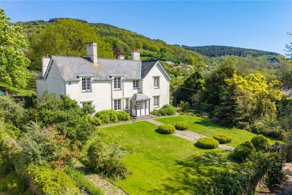
- Price
- Guide Price£1,450,000
- Size
- 49.67 acres
Wootton Courtenay, Minehead, Somerset, TA24, Wootton Courtenay, Somerset TA24 England
Added on 10/05/2026Farm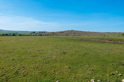
- Price
- Guide Price£1,400,000
- Size
- 141.4 acres
Added on 04/06/2026Farm