Goodens Lane, Great Doddington, Wellingborough, Northamptonshire, NN29
- Land size
- 269 acres
- Bedrooms
- 5
- Bathrooms
- 3
Key Features
- Modern farmhouse with annexe potential
- Five bedrooms, three bath or shower rooms
- Four reception rooms and a home office
- Open plan kitchen/dining room, utility room, pantry
- Southerly facing garden with panoramic views
- Approximately 269 acres of land with river frontage
- Solar panels
- Nearly 27,000 sq. ft. of agricultural buildings
Description
A modern five bedroom farmhouse with annexe potential, gated driveway parking, a garage, agricultural buildings, and 269 acres of land with river frontage and panoramic views over the Summer Leys Nature Reserve. The vendors have owned the property since 1985 and built the current farmhouse in 1992. It is of mellow stone under a clay tiled roof and provides over 3,500 sq. ft. of versatile accommodation over two floors with the potential to create a self-contained one bedroom annexe in one wing.
The property is a working farm and has approximately 269 acres of land which includes grazing land, woodland and over 2km of river frontage with fishing rights (1.40km of single bank river frontage and 0.65km of double bank frontage). The land slopes away from the rear of the house which faces almost due south. Solar panels have been fitted on the roof at the rear to reduce bills.
The property has also been used as a sustainable, eco friendly wedding venue with the farm providing the land for tepees and marquees, and the flowers from their own cut flower garden in front of the house.
About the Property cont'd
A stone built workshop adjoining one of the agricultural buildings has a cloakroom, a kitchen area, space for tables and chairs, a seating area with a feature fireplace, and stairs up to a mezzanine level. This workshop has been used as the venue for brides to work on their flower arrangements and bouquets.
Ground Floor/Annexe Potential
The front door opens into a porch which has a window to the side and doors with wing windows to the reception hall which has a built-in storage cupboard, a two piece cloakroom, and stairs to the first floor with an understairs cupboard. There are double doors to the sitting room and doors to the home office, hobby room and kitchen/dining room. The property can also be accessed via an entrance hall at the other end of the house which has a walk-in storeroom with space for coats and shoes, and access to the kitchen/dining room, utility room, pantry, and a ground floor shower room as well as a wooden open tread staircase to a family room and bedroom above. These rooms could be used to create an annexe if required with the utility room converted into a kitchen to create self contained accommodation for extended family, staff or guests.
Kitchen/Dining Room
Tiled flooring continues into the open plan kitchen/dining room which is dual aspect with windows to the front and bi-fold doors spanning almost the entire width of the room and giving access to a paved terrace in the garden which has far reaching views over the farmland, the river, and the lakes of the Nature Reserve beyond. The dining area has a sideboard with cupboards and drawer storage, and space for a dining table to seat at least eight. A wide opening leads to the snug.
Kitchen cont'd
The kitchen has a range of two tone full height, wall and base units including a larder cupboard, pan drawers, a plate rack and wine storage. Granite worksurfaces incorporate a double butler sink with a mixer tap and separate filtered water tap. The central island has additional storage, a granite worksurface incorporating a prep sink with a flex hose tap, and a raised wooden breakfast bar with space to seat three. There is a two oven electric Aga set under a feature overmantel with an extractor fan. Either side of the Aga there is a Siemens induction hob and a gas hob, and other integrated appliances include a Bosch oven in the island, and space and plumbing for an American style fridge/freezer.
Pantry and Utility Room
The pantry has a range of bespoke shelves and wicker drawers as well as hanging space and room to store items like the vacuum cleaner. The utility room has a connecting door to the garage, a range of base units incorporating a Belfast sink under a window to the front, and space and plumbing for a washing machine and a tumble dryer.
Ground Floor Shower Room
The shower room is accessed via the entrance hall and has a window to the rear, a shower cubicle, a WC, a vanity washbasin and half height metro tiled walls and a tiled floor.
Reception Rooms
The triple aspect sitting room has a feature fireplace housing a log burning stove, and French doors with wing windows to the rear terrace. The home office is also dual aspect with doors to the terrace. It has an exposed wooden floor, and a recess with a built-in cupboard and display shelves. The snug is accessed via an opening from the dining area and has the same tiled flooring, a wide window with views to the rear and space for soft seating. The other ground floor reception room has a window to the front and is currently used as a hobby room but it could alternatively be used as a playroom or second office if required. The family room is on the first floor and could be used as part of a self contained annexe. It has wooden flooring, a vaulted ceiling with dual aspect Velux windows, and access to eaves storage.
First Floor
The stairs from the reception hall lead up to a landing with a window to the front, an airing cupboard housing the hot water tank, and a walk-in store room. The landing gives access to four double bedrooms and the family bathroom which has a bath with a shower attachment, a separate shower cubicle, a WC and a pedestal washbasin with half height wall tiling for splashbacks and a tiled floor.
Principal Bedroom Suite
The principal bedroom is currently being used as a dressing room and has dual aspect windows to the side and rear with far reaching countryside views, exposed painted wood flooring and an en suite with a patterned tiled floor, a freestanding ball and claw footed bath with shower attachment, a separate shower cubicle, and Charlotte WC and washbasin with a decorative flower design.
Other Bedrooms and Bathrooms
Bedroom two is currently being used as the principal bedroom and also has dual aspect windows to the rear and side with panoramic countryside views. Bedroom three has dual aspect windows to the front and side and bedroom four overlooks the front. Bedroom five is accessed via double doors from the family room in the potential annexe area of the property. It has wood flooring and a vaulted ceiling with Velux windows to the front and rear and a window to the side looking over the fields to the farmyard and agricultural buildings. There is a built-in store room.
Gardens and Grounds
The property is at the end of a no through road and is accessed via twin wrought iron gates in a stone boundary wall. The drive leads up to the front of the property where there is a turning circle, and parking for several cars in addition to the nearly 21 ft. integral garage which has an electric sectional up and over door, a window to the side and a door to the utility room. The garden is enclosed by a combination of walls, post and rail fencing and mature hedges, and is mainly lawned with a variety of mature trees interspersed. Paved paths on both sides of the house lead to the rear garden which is southerly facing and has an extensive paved terrace which spans the full width of the house and has outside lighting and ample space for barbecues and tables and chairs for al fresco dining and entertaining.
Gardens cont'd
The raised terrace outside the sitting room is bordered by a low stone wall and has steps down to the lawned garden which has established borders with shrubs including roses, lavatera and buddleia and a low picket fence so that the panoramic views to the horizon are not obscured. The drive continues over a cattle grid to a farmyard and collection of agricultural buildings which are grouped around an area of hardstanding. On the left just after the cattle grid there is a fenced vegetable garden which has been used in recent years to provide cut flowers for bridal bouquets for the weddings held at the property.
Agricultural Land
The holding extends to approximately 269 acres (108.86 hectares) and comprises permanent pasture, ancillary woodland and a farmyard with a comprehensive range of farm buildings. The pasture (260.35 acres) is divided into 17 fields which are split by mature hedgerows and fences, and one field separated by the River Nene. The land is currently used to graze sheep and cattle, and for the production of hay. The 5.77 acres of woodland is split into 7 small copses, which are well spread across the farm. The farmyard (1.47 acres) has a central concrete yard with five portal frame buildings and two unsurfaced/livestock-holding yards. Access to the main block of land is available via the farmhouse from Goodings Lane, but there is also direct access from the B573 via field gate. The single field lying to the south of the River Nene benefits from its own access via a private road leading from Hardwater Road.
Land Classification and Soils
The land is classified as Grade 3 and 4 according to the Agricultural Land Classification of England and Wales. The soil type is classified as the Moreton series and the Fladbury 1 series described as clayey over limestone and seasonally wet deep clay respectively according to the Soil Survey of England and Wales.
Environmental Schemes
The majority of the farmland is entered into a Sustainable Farming Incentive (SFI) agreement, which commenced on 1st October 2025. The agreement includes a range of actions including nutrient management, hedgerow management and winter bird food options. The scheme is non-transferable so will terminate on transfer, thus enabling the alternative schemes to be applied for. Immediately to the south of the River Nene is the Upper Nene Gravel Pits SSSI, this adjoins the single field to the south of the river. The SSSI does not form part of the holding but Natural England have expressed an interest to support a Higher Tier environmental agreement to complement the surrounding wetland areas.
Wayleaves, Easements and Rights of Way
The property is being sold subject to and with the benefit of all rights including; rights of way, whether public or private, light, support, drainage, water, gas and electricity supplies, easements, quasi-easements or wayleaves, and other rights and obligations whether referred to in these particulars or not. There are three public footpaths and a byway that cross the property. A gas main, a 11kV overhead electricity line and a 132kV high-voltage pylon line also cross the agricultural land.
Uplift
The land is sold subject to a 50% uplift in value of future non-agricultural development over the land shaded purple on the plan. The uplift runs for 25 years from 28th October 2025 and does not apply to farm scale diversification.
Agricultural Buildings
The farmyard comprises a range of five principally steel-framed agricultural buildings, predominantly used for livestock purposes. The buildings comprise: 1. Livestock Building – 35.78m x 10.98m Open-sided, steel-framed livestock building with blockwork walls and Yorkshire boarding under a pitched fibre cement roof. 2. Livestock Building – 22.38m x 10.98m Open-sided, steel-framed livestock building adjoining Building 1 at the gable end, with blockwork walls and Yorkshire boarding under a pitched fibre cement roof. 3. Livestock Building – 33.02m x 30.90m Steel-framed livestock building with blockwork walls and Yorkshire boarding under a pitched fibre cement roof with a lean-to section. 4. Agricultural Building – 31.95m x 15.81m Smaller general purpose agricultural building under a pitched roof. Steel-framed building with blockwork walls and Yorkshire boarding under a pitched fibre cement roof
Agricultural Buildings cont'd
5. Agricultural Building – 34.85m x 9.50m Steel-framed agricultural building with blockwork walls and Yorkshire boarding under a mono-pitched fibre cement roof.
Other
All sporting, timber and mineral rights are included in the sale, in so far as they are owned. The whole of the holding lies within a Nitrate Vulnerable Zone (NVZ).
Situation and Schooling
Great Doddington is located between Northampton and Wellingborough and overlooks the Nene Valley and the Nature Reserve of Summer Leys. The village has a church, a chapel, two shops, a public house and a village hall. There are recreation fields for football etc. and a play park. The village has a pre-school nursery and a primary school. Other local schools are Wollaston School, Wellingborough School, Northampton High School for girls in Hardingstone and Northampton School for Boys, Northampton.
Map Location
Property details
- Tenure
- Freehold
- Council Tax Band
- G
- Date Posted
- 2026-10-02
Market Value Analysis
Compared with 10 Farms & Smallholdings listings in East Midlands (250+ acres).
Energy Performance Certificate
Energy Efficiency Rating
Based on UK Energy Performance Certificate standards (EU Directive 2002/91/EC)
Running costs are one side. Planning activity, flood history and ground risks for this location are in the full report.
Utilities & Restrictions
Utilities
- Electricity
- Mains
- Water
- Mains
- Heating
- Gas Heating
- Broadband
- Ask Agent
- Sewerage
- Septic Tank / Private
Rights & Restrictions
- Public Rights of Way
- Yes
- Private Rights of Way
- Ask Agent
- Listed Property
- Ask Agent
- Restrictions
- Ask Agent
Listed status, conservation areas and planning constraints for this location are in the full report.
Property Features
- Accessibility
- Ask Agent
- Parking
- Off-Street Parking
- Garden
- Garden
Beyond the particulars: planning activity, flood history, heritage and ground risks, checked for this exact spot.
Connectivity
Broadband
Fastest speed available at this postcode
1.8 Gbps
Gigabit full fibre
Suitable for
- 4K streaming on every screen
- Full-time home working
- Online gaming & big downloads
Mobile signal
Predicted 4G and 5G signal; indoor signal depends on building materials.
Ofcom Connected Nations postcode-level predictions. Speeds and signal are modelled, not measured, and vary between addresses and providers.
Signal is the easy part. Planning activity, flood history and protected designations here are in the full report.
Nearest Schools
Primary
- Great Doddington Primary620 metresOfsted: Good *
- Ages
- 4 to 11
- Pupils
- 126
- Type
- Community school
- Warwick Academy0.9 milesOfsted: Good
- Ages
- 2 to 11
- Pupils
- 258
- Type
- Academy sponsor led
- Our Lady's Catholic Primary School1.4 milesOfsted: Requires improvement
- Ages
- 4 to 11
- Pupils
- 303
- Type
- Academy sponsor led
- Faith
- Roman Catholic
- Croyland Primary School1.5 milesOfsted: Good
- Ages
- 5 to 11
- Pupils
- 414
- Type
- Community school
- St Barnabas Church of England School1.8 milesNo Ofsted rating
- Ages
- 5 to 7
- Pupils
- 170
- Type
- Academy sponsor led
- Faith
- Church of England
Secondary
- Wrenn School1.5 milesNo Ofsted rating
- Ages
- 11 to 18
- Pupils
- 1,537
- Type
- Academy sponsor led
- Weavers Academy1.9 milesNo Ofsted rating
- Ages
- 11 to 18
- Pupils
- 1,275
- Type
- Academy sponsor led
- Wollaston School2.1 milesOfsted: Good
- Ages
- 11 to 18
- Pupils
- 1,432
- Type
- Academy converter
- Sir Christopher Hatton Academy2.3 milesOfsted: Good
- Ages
- 11 to 18
- Pupils
- 1,440
- Type
- Academy converter
- Rushden Academy4.3 milesOfsted: Good
- Ages
- 11 to 18
- Pupils
- 961
- Type
- Academy sponsor led
* Latest graded judgement covers quality of education only; no overall grade was issued under the 2024-25 inspection framework.
Distances are straight-line from the advertised location. Source: the national school registers (DfE, Welsh Government, Scottish Government) and Ofsted.
Schools are just the start: sold prices nearby, planning activity and any flood history are in the full report.
Amenities
Supermarket
GP surgery
Pharmacy
Hospital
Green space
Straight-line distances from the advertised location. Sources: NHS records, Geolytix supermarket locations, OS Open Greenspace and the national trails registers.
The area stacks up? Now check the location itself: planning nearby, protected designations and past flooding.
Getting Around
Nearest station
Nearest bus stop
Typical drive times
Straight-line distances from the advertised location; drive times are typical free-flow times over OpenStreetMap road data, so allow more at peak. Public transport locations from DfT NaPTAN.
Easy to reach matters. So do planning activity, flood history and ground risks: all in the full report.
Flood Risk
Environment Agency open data, checked around the advertised map pin for the listed acreage. Long-term risk counts flood defences; the planning map's flood zones do not. Provided by LandSale, not the listing agent, and not part of the agent's particulars. Risk varies across a holding, so verify before committing.
Rivers and the sea
Not at the pin: mapped about 380 metres away.
Planning map: Flood Zone 3, about 370 metres away.
Surface water
Not at the pin: mapped about 200 metres away.
These bandings are the summary. Where this location sits on the flood maps, plus planning activity, heritage and ground risks, is in the full report.
Important notice: Information, maps and tags on this page are drawn from the advertising agent's marketing materials or generated automatically. LandSale has not verified them. Relying on these details is at your own risk, always carry out independent checks before committing to a purchase.
LandSale full disclaimer
Marketing information only - not formal particulars. The details on this website are provided for general guidance and do not constitute an offer or contract. Neither LandSale nor the advertising estate/land agent accepts responsibility for any inaccuracy.
1. Source of information
- Listing content: Core description, asking price, tenure, measurements, photographs and planning history originate from the marketing materials of the advertising estate or land agent. LandSale does not author this content and cannot guarantee its accuracy.
- Automated tags & categorisation: Property type, land-use class, acreage bands and similar labels may be applied by machine-learning models. They are intended as a helpful guide only and may not reflect the property's legal status or permitted use.
- Third-party & enriched data layers: Maps, boundary outlines, planning designations, soil reports, broadband coverage and other environmental or location-based insights are licensed from external suppliers. Such data are supplied “as is", may be incomplete or out of date and are subject to change without notice.
2. Verification required
Prospective purchasers must verify critical matters, including but not limited to planning permission, title boundaries, public rights of way, environmental constraints, acreage, services, access and VAT status, through their own inspections, specialist surveys, legal advisers and the selling agent before relying on the information or entering into any contract.
3. No warranty or liability
LandSale gives no warranty, express or implied, as to the accuracy, completeness or fitness for any particular purpose of the information displayed. LandSale shall not be liable for any loss, damage, cost or expense arising directly or indirectly from any use of or reliance on such information, save where liability may not be excluded by law.
4. Updates & feedback
If you believe any detail on this listing is inaccurate, please let us know. We will investigate and, where appropriate, update the listing or notify the agent.
© LandSale | Version 1.3 - August 2026
Listing agent
Michael Graham, Towcester
138 Watling Street East, Towcester, NN12 6BT
Similar properties for sale
- Price
- Guide Price£5,600,000
- Size
- 256.28 acres
Hanslope Road, Hartwell, Hartwell, West Northamptonshire NN7 England
Added on 03/04/2026Farm
- Price
- Guide Price£5,600,000
- Size
- 256 acres
Hartwell Road, Hartwell, Northants, NN7, Castlethorpe, Milton Keynes MK19 England
Added on 03/04/2026Farm
- Price
- Guide Price£4,750,000
- Size
- 275 acres
Priors Marston Road, Byfield, NN11, Byfield, West Northamptonshire NN11 England
Added on 03/06/2026Farm
- Price
- Guide Price£4,500,000
- Size
- 144.14 acres
Bushey Lane, Preston Bissett, Preston Bissett, Buckinghamshire MK18 England
Added on 21/05/2026Farm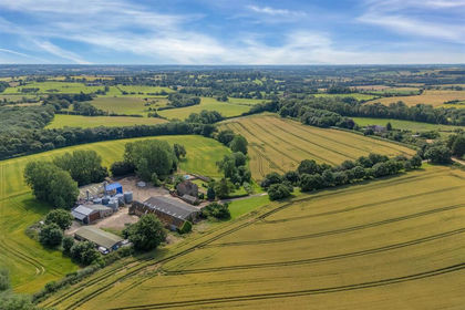
- Price
- Guide Price£4,500,000
- Size
- 327.1 acres
Avon Dassett, Southam, Avon Dassett, Warwickshire CV47 England
Added on 29/01/2026Farm