Priors Marston Road, Byfield, NN11
- Land size
- 275 acres
- Bedrooms
- 7
- Bathrooms
- 3
Key Features
- Spacious seven bedroomed farmhouse.
- Peaceful rural location with undulating landscape.
- Approx. 275 acres (approx. 111 hectares) of arable, pasture, woodland, orchards and water areas.
- Traditional buildings including two double-height stone barns.
- Environmentally friendly haven for wildlife.
Description
Situated in a quiet rural location, Pitwell Farm, which measures approx. 4388 sq. ft and sits within approx. 275 acres, with a substantial range of buildings, including traditional single storey ranges and, importantly, two large double-height stone barns. The principal farm building is the grain store.
Description
Pitwell Farm comes to the market for the first time since 1995. The age of the house is unknown but believed to be rebuilt on the site of the former late 18th century house. There is a date stone in one of the stone barns of circa 1732. The house is situated in a quiet rural location, set back from the road, with a substantial range of buildings to the north, including traditional single storey ranges and, importantly, two large double-height stone barns. The principal farm building is the grain store but there are other covered areas. The majority of the land has a westerly aspect, situated in attractive undulating countryside and separated only near the western boundary by the canal feeder to the Boddington Reservoir. The holding extends in total to approximately 275 acres (approx. 111 hectares) from information taken from the Rural Land Register.
Pitwell Farmhouse
Pitwell Farmhouse offers spacious accommodation throughout, brick built under a tiled roof with dormer windows, sitting at approx. 4388 sq. ft. (407 sq. m.), situated over four floors. A central entrance hallway leads to multiple reception rooms, with the front sitting room and formal dining room overlooking an enclosed walled garden and orchard beyond. Accessed via an inner hallway, there are two dedicated study rooms, along with a breakfast room which in turn gives access to a sunroom with picture windows to southerly and westerly elevations with added skylights, and a sizeable farmhouse kitchen leading to a utility / boot room, pantry and boot storage. Below the front reception rooms are cellar compartments which could convert to create wine cellars. The kitchen offers views to the west over a further orchard edged by an avenue of trees on either side. From the first and second floors, with central spacious landings, expect to find seven well-proportioned (truncated)
The Land
The 2023 Basic Payment Application detailed the following descriptions: • Permanent grassland – 16.61 acres • Arable land – 185.62 acres • Stewardship/Fallow – 46.41 acres • Fruit orchards – 10.50 acres • Woodlands – 9.78 acres • Water – 0.39 acres • Remaining – 1.84 acres The total maximum area eligible for BPS at that time was 259 acres. The arable land has recently been cropped throughout with spring wheat, as it is today. The pastures have been generally mown, but there are sheep on the farm for the first time this year. The soil type is a lighter free draining loam on the eastern boundary and heavier as the land falls away towards the western edge. There have been historically a number of drainage schemes carried out, including whole field schemes, particularly towards the west and further details are available from the agents. An attractive feature of the farm are the apple and pear orchards which have not been managed recently, having been planted many years (truncated)
The Farm Buildings
The aerial photograph illustrates the buildings, which are all situated in the yard to the north of the farmhouse and approached over the same access drive. 1. A modern five bay steel framed grain store (30 metres x 17 metres) with concrete floor, roller shutter access at one end and 2.4-metre-high concrete panels on three elevations with sheeting above. The vendor will leave the conveyors and elevators. 2. Six bay curved roof Dutch Barn with lean-to and two bay end extension. 3. Light steel framed covered yard with corrugated sheeted roof with extensions. 4. A double-height stone and slate roof traditional barn with part loft area and under store. 5. A double-height stone and sheeted roof barn with circa 1732 date stone. 6. Single storey traditional ranges used for garaging, general storage and former shoot room. The buildings offer obvious potential for alternative uses with the exceptional stone barns and the ability to free up the setting of the buildings by (truncated)
Location
Pitwell Farm lies in West Northamptonshire, approximately one mile northwest of Byfield. The A361 connects to Daventry approximately 8 miles to the north and Banbury approximately 10 miles to the south, where there is a mainline train station and easy access to the M40.
GPS Location Search
What 3 Words: ///executive.unafraid.theme
Method of Sale
Pitwell Farm is offered for sale by private treaty. It is anticipated, as the farm lies in a ring-fence, that the property will be sold as a whole. That’s not to say offers will not be considered for other sensible parcels. The intention would be to complete the sale after harvest and, depending on timings, to enable the purchaser to sow their own crops. The vendor may require an element of holdover in the grain store. The condition of the farm will be as at the date of completion.
Tenure and Possession
The farm is sold freehold with vacant possession available throughout on completion.
Energy Performance Certificate
The EPC rating is G.
Services
There is a single metered water supply that serves the holding. Mains electricity is connected, including 3 Phase into the buildings. The foul drainage from the Farmhouse feeds to a private system. The house has an LPG central heating system.
Environmental Stewardship
The land is all entered into an Environmental Stewardship Higher Level Stewardship Scheme which is running now from year to year. The anniversary date is 31st March and further details are available. The vendor has also recently entered into a Sustainable Farming Incentive Scheme and, again, further details are available.
Sporting, Timber and Minerals
In so far as they are owned, the above are all included in the sale of the freehold.
Local Authority and Planning History
The property falls under the jurisdiction of the West Northamptonshire Council, formerly within Daventry District. There are no listed buildings on the property, nor does the property lie within any Conservation Area. There have been no recent planning applications submitted by the vendor. Pitwell Farmhouse falls within Property Band F for the assessment of Council Tax and the gross charge for the period 1st April 2025 to 31st March 2026 is £3,498.87.
Licence to Extract Water
A Licence was granted by The Environment Agency on 16th July 1998 to extract from a borehole for the benefit of Pitwell Farm. The Licence is still used. The maximum quantity of water that can be extracted during any year is 1137 cubic metres.
Development Clawback
The vendor will retain an interest in 30% of any additional value obtained through planning consent for renewable energy schemes, including solar arrays, battery storage or turbines for a period of 30 years. There are no other overage arrangements. The trigger for the valuation exercise is the implementation of any relevant planning consent or the sale with the benefit of planning consent. There will be deductible costs allowed which will include any sale costs, the expenses incurred in obtaining planning consent and the development partners reward be it either an option discount or promotion percentage. A base value will also be deductible being the market value of the land at the time of the planning consent but disregarding the consent itself.
Fixtures and Fittings
The sale excludes any obvious fixtures and fittings that are removable, but the vendor will leave the fitted carpets, light fittings and curtains by arrangement.
VAT
The vendor has not waived the exemption or opted for VAT and therefore no VAT is payable in addition to the purchase price.
Easements, Wayleaves and Rights of Way
The farm is offered to sale subject to and with the benefit of all existing easements, wayleaves and rights of way, whether specifically mentioned or not. There is a footpath that crosses the farm which is marked on the farm plan. There are also overhead electricity wires and there will be no apportionment of the current year’s wayleave.
Plans and Boundaries
The plans within these particulars are provided for reference only and, although believed to be correct, the accuracy cannot be guaranteed. The purchaser will be deemed to have full knowledge of all boundaries and the extent of ownership. Neither the vendor nor the vendor’s agents can be responsible for defining the boundaries or the ownership thereof.
Reservation for Farm Sale
The vendor will reserve the right to hold a sale of implements, machinery, etc., on the property on a date to be agreed.
Solicitor
Kate Austin of Arnold Thomson in Towcester is acting for the vendor and any enquires of a legal nature should be addressed to Kate on either or kate. .
Viewing
Viewing must be strictly by prior appointment with the agents.
Map Location
Property details
- Tenure
- Freehold
- Council Tax Band
- F
- Date Posted
- 2026-06-03
Price history
| Date | Change | Price |
|---|---|---|
| 7 Oct 2026 | Reduced 9.5% (−£500,000) | £4,750,000 |
| Until 7 Oct 2026 | Asking price | £5,250,000 |
Market Value Analysis
Compared with 10 Farms & Smallholdings listings in East Midlands (250+ acres).
Utilities & Restrictions
Utilities
- Electricity
- Ask Agent
- Water
- Ask Agent
- Heating
- Ask Agent
- Broadband
- Ask Agent
- Sewerage
- Ask Agent
Rights & Restrictions
- Public Rights of Way
- Ask Agent
- Private Rights of Way
- Ask Agent
- Listed Property
- Ask Agent
- Restrictions
- Ask Agent
Listed status, conservation areas and planning constraints for this location are in the full report.
Property Features
- Accessibility
- Ask Agent
- Parking
- Parking Available
- Garden
- Garden
Beyond the particulars: planning activity, flood history, heritage and ground risks, checked for this exact spot.
Connectivity
Broadband
Fastest speed available at this postcode
16 Mbps
Standard (10-30 Mbps)
Suitable for
- Web & social
- Music streaming
- Standard video calls
Mobile signal
Predicted 4G and 5G signal; indoor signal depends on building materials.
Ofcom Connected Nations postcode-level predictions. Speeds and signal are modelled, not measured, and vary between addresses and providers.
Signal is the easy part. Planning activity, flood history and protected designations here are in the full report.
Nearest Schools
Primary
- Byfield School1 mileOfsted: Good
- Ages
- 2 to 11
- Pupils
- 108
- Type
- Academy converter
- Boddington Church of England Primary Academy1.5 milesNo Ofsted rating
- Ages
- 2 to 11
- Pupils
- 52
- Type
- Academy converter
- Faith
- Church of England
- St Mary's Catholic Primary School, Aston-le-Walls2.2 milesNo Ofsted rating
- Ages
- 3 to 11
- Pupils
- 81
- Type
- Voluntary aided school
- Faith
- Roman Catholic
- The Priors School2.2 milesNo Ofsted rating
- Ages
- 2 to 11
- Pupils
- 102
- Type
- Free schools
- Woodford Halse Church of England Primary Academy2.7 milesOfsted: Good
- Ages
- 2 to 11
- Pupils
- 207
- Type
- Academy converter
- Faith
- Church of England
Secondary
- DSLV E-ACT Academy7 milesOfsted: Good
- Ages
- 3 to 18
- Pupils
- 997
- Type
- Academy sponsor led
- The Parker E-ACT Academy7 milesOfsted: Inadequate *
- Ages
- 11 to 18
- Pupils
- 1,132
- Type
- Academy sponsor led
- Chenderit School7.4 milesOfsted: Good
- Ages
- 11 to 18
- Pupils
- 1,104
- Type
- Academy converter
- Southam College7.5 milesOfsted report card · Apr 2026
- Ages
- 11 to 18
- Pupils
- 1,637
- Type
- Academy converter
- North Oxfordshire Academy8.9 milesNo Ofsted rating
- Ages
- 11 to 19
- Pupils
- 1,004
- Type
- Academy sponsor led
* Latest graded judgement covers quality of education only; no overall grade was issued under the 2024-25 inspection framework.
Distances are straight-line from the advertised location. Source: the national school registers (DfE, Welsh Government, Scottish Government) and Ofsted.
Schools are just the start: sold prices nearby, planning activity and any flood history are in the full report.
Amenities
Supermarket
GP surgery
Pharmacy
Hospital
Straight-line distances from the advertised location. Sources: NHS records, Geolytix supermarket locations, OS Open Greenspace and the national trails registers.
The area stacks up? Now check the location itself: planning nearby, protected designations and past flooding.
Getting Around
Nearest station
Nearest bus stop
Typical drive times
Straight-line distances from the advertised location; drive times are typical free-flow times over OpenStreetMap road data, so allow more at peak. Public transport locations from DfT NaPTAN.
Easy to reach matters. So do planning activity, flood history and ground risks: all in the full report.
Flood Risk
Environment Agency open data, checked around the advertised map pin for the listed acreage. Long-term risk counts flood defences; the planning map's flood zones do not. Provided by LandSale, not the listing agent, and not part of the agent's particulars. Risk varies across a holding, so verify before committing.
Rivers and the sea
Planning map: Flood Zone 1.
Surface water
Not at the pin: mapped about 220 metres away.
These bandings are the summary. Where this location sits on the flood maps, plus planning activity, heritage and ground risks, is in the full report.
Important notice: Information, maps and tags on this page are drawn from the advertising agent's marketing materials or generated automatically. LandSale has not verified them. Relying on these details is at your own risk, always carry out independent checks before committing to a purchase.
LandSale full disclaimer
Marketing information only - not formal particulars. The details on this website are provided for general guidance and do not constitute an offer or contract. Neither LandSale nor the advertising estate/land agent accepts responsibility for any inaccuracy.
1. Source of information
- Listing content: Core description, asking price, tenure, measurements, photographs and planning history originate from the marketing materials of the advertising estate or land agent. LandSale does not author this content and cannot guarantee its accuracy.
- Automated tags & categorisation: Property type, land-use class, acreage bands and similar labels may be applied by machine-learning models. They are intended as a helpful guide only and may not reflect the property's legal status or permitted use.
- Third-party & enriched data layers: Maps, boundary outlines, planning designations, soil reports, broadband coverage and other environmental or location-based insights are licensed from external suppliers. Such data are supplied “as is", may be incomplete or out of date and are subject to change without notice.
2. Verification required
Prospective purchasers must verify critical matters, including but not limited to planning permission, title boundaries, public rights of way, environmental constraints, acreage, services, access and VAT status, through their own inspections, specialist surveys, legal advisers and the selling agent before relying on the information or entering into any contract.
3. No warranty or liability
LandSale gives no warranty, express or implied, as to the accuracy, completeness or fitness for any particular purpose of the information displayed. LandSale shall not be liable for any loss, damage, cost or expense arising directly or indirectly from any use of or reliance on such information, save where liability may not be excluded by law.
4. Updates & feedback
If you believe any detail on this listing is inaccurate, please let us know. We will investigate and, where appropriate, update the listing or notify the agent.
© LandSale | Version 1.3 - August 2026
Listing agent
Berrys, Kettering
42 Headlands, Kettering, NN15 7HR
Similar properties for sale
- Price
- Guide Price£4,500,000
- Size
- 327.1 acres
Avon Dassett, Southam, Avon Dassett, Warwickshire CV47 England
Added on 29/01/2026Farm
- Price
- Guide Price£4,500,000
- Size
- 144.14 acres
Bushey Lane, Preston Bissett, Preston Bissett, Buckinghamshire MK18 England
Added on 21/05/2026Farm
- Price
- Guide Price£5,600,000
- Size
- 256.28 acres
Hanslope Road, Hartwell, Hartwell, West Northamptonshire NN7 England
Added on 03/04/2026Farm
- Price
- Guide Price£5,600,000
- Size
- 256 acres
Hartwell Road, Hartwell, Northants, NN7, Castlethorpe, Milton Keynes MK19 England
Added on 03/04/2026Farm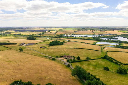
- Price
- Offers in Excess of£4,500,000
- Size
- 269 acres
Added on 02/10/2026Farm