Dagmar Wood, Durris, Banchory, Aberdeenshire, Northern Scotland, AB31
- Land size
- 5 acres
Key Features
- Approximately 5 acres of private mixed woodland
- Attractive mix of mature Sitka spruce and birch
- Good vehicular access via established forest track
- Parking / timber stacking area at the woodland entrance
- Internal tracks and paths providing access through the wood
- Peaceful location within Royal Deeside, near Banchory
- Sporting and mineral rights included
Description
The name Dagmar comes from old Norse and means 'day' or 'daughter', no real relevance to the wood but a name is a name.
This is a lovely secluded spot in the wonderful valley of Royal Deeside home to Balmoral castle a favoured residence of the late queen. Our woods are a bit more humble than balmoral but no doubt will become just as important a redoubt for somebody.
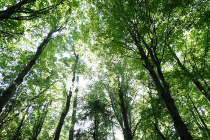
The walk up from the main entrance feels quite grand with tall towering beech trees creating a vaulted canopy. The track splits and rises leading all the way up to Dagmar Wood. There is a generous parking or timber stacking area at the entrance. From here the track leads further into the wood, this section has not been upgraded but could be used by a 4X4 without too much difficulty.
There is plenty of scope to create a hub for your woodland here whether as a low impact camp or something sturdier, though planning permission is generally required for any hut building.
Though the wood is on the side of a slope there are a few flatter places at the end of the track and at the top of the woodland where there is a lovely birch glade that would be ideal for camping.
This is a lovely area and a wonderful woodland that will appeal to many.
The purchasers of the woodland will be asked to enter into a covenant to ensure the quiet and peaceful enjoyment of adjoining woodlands and meadows.
Trees
There is a real mix to the trees in this woodland, a large stand of Sitka spruce that would benefit from some thinning and a large area of birch towards the west and up the top that are fine as is. Some bits of windblow have been tidied up with the timber left in situ giving plenty of ready cut firewood waiting to be hauled out of the wood by the new owner. Not enough for commercial uses but enough to supply a winter's worth of firewood.
Wildlife
Wildlife on the whole prefer places with plenty of cover to go about their business and this woodland certainly fits the bill. In the height of summer there is a carpet of fern amongst the birch that can be awkward to traverse for ungainly humans but will no doubt have a myriad of paths made by the smaller creatures that inhabit the woodland.
Features
This wood is tucked away in the corner of the forest giving it a good level of privacy, it is rich in biodiversity which is a sign of a healthy woodland. Thinning of the sitka would improve the biodiversity further.
Access, tracks and footpaths
The main track leading up to the entrance of the wood has been upgraded, the track through Dagmar wood has not been but remains relatively clear. There are a few paths through the wood.
Rights and covenants
All sporting and mineral rights are sold with the woodland.
The purchasers of the woodland will be asked to enter into a covenant to ensure the quiet and peaceful enjoyment of adjoining woodlands and meadows.
Activities
This woodland would be perfect for all manner of activities whether as a site for a log cabin, a place to camp out with the grandkids or just as a wee haven away from the bustle of modern life.
Local area and history
Royal Deeside is the name given to the valley of the River Dee from its birth on the slopes of the Cairngorm Mountains to the North Sea at Aberdeen. On its journey, the river flows through some of the most beautiful countryside in Scotland.
There are several historic castles located in Deeside. At Braemar, the crumbling ruins of Kindrochit Castle date back to the 11th century. At the east end of Braemar stands the 16th-century tower house of Braemar Castle. Braemar itself is famous as the site of the annual Highland Gathering, the most prestigious of Scotland's Highland Games, which can trace their origins back to a festival given by Malcolm Canmore following his victory over Macbeth here in the 11th century.
The 16th-century tower house of Crathes Castle at Banchory features world-famous gardens, and only a few miles away is the 13th-century fortress of Drum Castle, one of the oldest tower houses in the country. Just outside Royal Deeside are Craigievar Castle, Corgarff Castle, and Dunnottar Castle.
How to find this woodland
You are welcome to visit this wood by yourself, but please ensure that you have a copy of these sales details with you - many of our woodlands do not have mobile phone reception or internet access so we recommend either printing the details or downloading them to your phone/tablet/laptop.
Do remember to also check that it is still available for sale. If you have seen the woodland and wish to be accompanied on a second more detailed visit please contact our local manager.
Directions
From the A90 western periphery road that bypasses Aberdeen take the turnoff for Peterculter onto the B979.
Go down from here back across the river and join the B9077 turning right (South Deeside Road).
Carry along here for about 3 miles.
You will come across a woodlands for sale sign on your left and then half a mile further a sign on your right.
The entrance to the wood is opposite the sign on your left hand side.
Park here and try to leave room for a car to get into or out of the gate.
Walk up the internal track bearing left until you reach the end and the entrance to Dagmar wood.
what3words suggested.pelt.outlooks
Our regional managers are often out working in our woodlands, so if you email an offer and want to be sure it has been received, please phone our manager on his or her mobile phone. The first offer at the stated price which is accepted, whether by phone or email, has priority.
Please take care when viewing as the great outdoors can contain unexpected hazards and woodlands are no exception. You should exercise common sense and caution, such as wearing appropriate footwear and avoiding visiting during high winds.
All woodlands are sold at a fixed price, and include free membership of the Small Woodland Owners Group and the Royal Forestry Society, as well as £300 towards paying for a course (or courses) to help with managing and enjoying your woodland.
These particulars are for guidance only and, though believed to be correct, do not form part of any contract. Woodland Investment Management Ltd hereby give notice under section 21 of the Estate Agents Act 1979 of their interest in the land being sold.
Map Location
Property details
- Tenure
- Freehold
- Council Tax Band
- Ask Agent
- Date Posted
- 2026-09-28
Market Value Analysis
Compared with 52 Woodland listings in Scotland (5+ acres).
Property Brochure
Seen the details? The full report adds the independent checks: planning activity, flood history, heritage and ground.
Utilities & Restrictions
Utilities
- Electricity
- Ask Agent
- Water
- Ask Agent
- Heating
- Ask Agent
- Broadband
- Ask Agent
- Sewerage
- Ask Agent
Rights & Restrictions
- Public Rights of Way
- Ask Agent
- Private Rights of Way
- Ask Agent
- Listed Property
- Ask Agent
- Restrictions
- Ask Agent
Listed status, conservation areas and planning constraints for this location are in the full report.
Property Features
- Accessibility
- Ask Agent
- Parking
- Ask Agent
- Garden
- Ask Agent
Beyond the particulars: planning activity, flood history, heritage and ground risks, checked for this exact spot.
Connectivity
Broadband
Fastest speed available at this postcode
26 Mbps
Standard (10-30 Mbps)
Suitable for
- Web & social
- Music streaming
- Standard video calls
Mobile signal
Predicted 4G and 5G signal; indoor signal depends on building materials.
Ofcom Connected Nations postcode-level predictions. Speeds and signal are modelled, not measured, and vary between addresses and providers.
Signal is the easy part. Planning activity, flood history and protected designations here are in the full report.
Nearest Schools
Primary
- Drumoak School1.7 miles
- Pupils
- 131
- Type
- Non-denominational
- Durris School2 miles
- Pupils
- 43
- Type
- Non-denominational
- Culter School2.5 miles
- Pupils
- 283
- Type
- Non-denominational
- Lairhillock School3 miles
- Pupils
- 128
- Type
- Non-denominational
- Milltimber School4 miles
- Pupils
- 310
- Type
- Non-denominational
Secondary
- Cults Academy5.5 miles
- Pupils
- 1,275
- Type
- Non-denominational
- Westhill Academy5.9 miles
- Pupils
- 847
- Type
- Non-denominational
- Portlethen Academy6.6 miles
- Pupils
- 944
- Type
- Non-denominational
- Hazlehead Academy7 miles
- Pupils
- 1,074
- Type
- Non-denominational
- Banchory Academy7 miles
- Pupils
- 865
- Type
- Non-denominational
Distances are straight-line from the advertised location. Source: the national school registers (DfE, Welsh Government, Scottish Government) and Ofsted.
Schools are just the start: planning activity, heritage and any flood history here are in the full report.
Amenities
Supermarket
GP surgery
Pharmacy
Walking trail
Straight-line distances from the advertised location. Sources: NHS records, Geolytix supermarket locations, OS Open Greenspace and the national trails registers.
The area stacks up? Now check the location itself: planning nearby, protected designations and past flooding.
Getting Around
Nearest station
Nearest bus stop
Typical drive times
Straight-line distances from the advertised location; drive times are typical free-flow times over OpenStreetMap road data, so allow more at peak. Public transport locations from DfT NaPTAN.
Easy to reach matters. So do planning activity, flood history and ground risks: all in the full report.
Flood Risk
SEPA open data, checked around the advertised map pin for the listed acreage. Provided by LandSale, not the listing agent, and not part of the agent's particulars. Risk varies across a holding, so verify before committing.
Rivers and the sea
Surface water
These bandings are the summary. Where this location sits on the flood maps, plus planning activity, heritage and ground risks, is in the full report.
Important notice: Information, maps and tags on this page are drawn from the advertising agent's marketing materials or generated automatically. LandSale has not verified them. Relying on these details is at your own risk, always carry out independent checks before committing to a purchase.
LandSale full disclaimer
Marketing information only - not formal particulars. The details on this website are provided for general guidance and do not constitute an offer or contract. Neither LandSale nor the advertising estate/land agent accepts responsibility for any inaccuracy.
1. Source of information
- Listing content: Core description, asking price, tenure, measurements, photographs and planning history originate from the marketing materials of the advertising estate or land agent. LandSale does not author this content and cannot guarantee its accuracy.
- Automated tags & categorisation: Property type, land-use class, acreage bands and similar labels may be applied by machine-learning models. They are intended as a helpful guide only and may not reflect the property's legal status or permitted use.
- Third-party & enriched data layers: Maps, boundary outlines, planning designations, soil reports, broadband coverage and other environmental or location-based insights are licensed from external suppliers. Such data are supplied “as is", may be incomplete or out of date and are subject to change without notice.
2. Verification required
Prospective purchasers must verify critical matters, including but not limited to planning permission, title boundaries, public rights of way, environmental constraints, acreage, services, access and VAT status, through their own inspections, specialist surveys, legal advisers and the selling agent before relying on the information or entering into any contract.
3. No warranty or liability
LandSale gives no warranty, express or implied, as to the accuracy, completeness or fitness for any particular purpose of the information displayed. LandSale shall not be liable for any loss, damage, cost or expense arising directly or indirectly from any use of or reliance on such information, save where liability may not be excluded by law.
4. Updates & feedback
If you believe any detail on this listing is inaccurate, please let us know. We will investigate and, where appropriate, update the listing or notify the agent.
© LandSale | Version 1.3 - August 2026

Similar properties for sale
- Price
- Fixed Price£59,000
- Size
- 5.25 acres
Jarl Wood, Durris, Banchory, Aberdeenshire, Northern Scotland, AB31, , Aberdeenshire AB31 Scotland
Added on 28/09/2026Woodland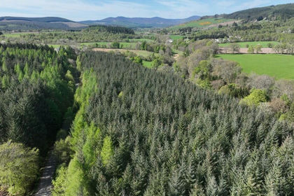
- Price
- Offers Over£75,000
- Size
- 11.22 acres
Affrusk Woodland, Banchory AB31, West Aberdeenshire and Kincardine, Aberdeenshire AB31 Scotland
Added on 29/01/2026Timberland