
Plot D11 Milchden / Blackness Lane Meadowlands Keston, Bromley, London BR2
- Land size
- 0.02 acres
Key Features
- The plot enjoys a pleasant aspect overlooking gently rolling countryside
- Nearest pub arround 5 minutes walk away
Description
Plot D11 Milchden Blackness Lane Keston, Bromley London - Several plots sold nearby
PERFECT FOR SMALL SCALE COMMERCIAL HORTICULTURE/NURSERY USE
Clearly defined perimiter with access and potential off plan Temporary storage ok if planting
Flexible purchase options available for this 80 m2 strategic plot located close to local amenities and residential areas, featuring express rights of way off the Blackness Lane access track:
Option A (Whole Plot as is) 80 m2: £5,000 (+ standard legal fees)
Option B (Sub-Divided Plot 40m2 £5,000 ALL-INCLUSIVE (of standard Land Registry conveyance transfer & legal completion costs)
Ideal Uses:
Versatile double-garage size footprint suitable for private parking space/s, country picnic spot, leisure visits, or long-term strategic land investment close to London. Sold as private amenity land.
A much sought after strategic scenic nature plot ideal for private leisure use, recreation, and picnicking growing or relaxing exploring etc. (Last one!)
🌳 "Own your own private plot in London and escape the city!
Plots of land available now for leisure, allotments, and private retreats etc
Create your own peaceful private green haven and enjoy endless picnics.
The plot even has utility rights+car access, so you can improve your plot.
Waterbutts allowed
Freehold 80m² London Micro-Plot for Sale | Off-Street Car Space /Amenity
Keston, London Borough of Bromley (Greater London)
Asking Price / Transfer: Direct Freehold Conveyancing (Deed of Transfer)
Level, well-drained grassland plot in Keston (Greater London).
Ideal for private off-street car parking, vehicle positioning, or individual amenity holding.
Title: 100% Freehold Sale via Deed of Transfer
Size: 80m²+ natural open land
Immediate access, and full Freehold title transfer upon final payment and completion of transfer
The plot offered is situated at the top of the plan see photo not to scale.
Plot D11 is 80m2 approximately the same size as a large double garage
and sits as a self-contained, prime micro-holding What would you do with it? 🌱 The grass has been cut and it has been well managed
Unlock a low-cost, low-barrier commercial project in a premium Greater London postcode. Under UK planning law, horticulture and plant cultivation are explicitly classified as agricultural land use.
This means you can immediately utilize this 7m x 14m plot for highly lucrative boutique plant production, nursery stock, micro-greens, or cut flower cultivation without the need for a costly, time-consuming commercial change-of-use application
Comment below —woodland retreat, wildlife haven, allotment, orchard or something completely different or just hold it and see what happens with other plots?
Excellent Natural Hardstanding: The plot features lime-rich loamy soil with excellent, rapid natural drainage so perfectly firm underfoot year-round for vehicle access, parking commercial vehicles, or stationing tool trailers and equipment.
Boutique Enterprise Potential: The undisturbed soil profile has been naturally preserved for over 30 years. It is exceptionally clean and fertile for chemical-free ideal specialty crops or commercial beekeeping or honey production etc
There is already some activity on site nearby eg The Truffles Farm.
with lots of wildlife Pheasants etc. The plot is offered without planning consent
Situated near a farmhouse valued at more than £1 million and within the Metropolitan Green Belt and growing fringe area (ideal long-term strategic holding with possible future allocation)
High-demand location with active inquiries and scheduled site viewings.
Investment Potential: Freehold status with potential Planning subject to consents being obtained.
Utility rights included with the option to connect lay and maintain pipes, wires, and cables etc
Uses include commercial horticulture, plant nursery, and boutique plant production all fully permitted under UK planning law without requiring any change of land use
Because horticulture is classified under the umbrella of agricultural use, a buyer does not have to go through the massive hurdle or expense of obtaining commercial planning permission from the London Borough of Bromley
Physical Dimensions approx 861+sq ft or 80m2 or 6m wide x 14mx 6m x 14m A plan showing the plot divided will be provided upon contract
Location & Access: Situated just off Layhams Road in London Borough of Bromley (Greater London one mile from Biggin Hill Airport
Charles Darwin's Down House in Downe is approximately 3 to 4 miles east Croydon 8.5 miles west and 21 miles south of the Thames
Pay outright by bank transfer or via Paypal
More plots available off market
• Email: landinvestmentstd@gmail.com or Text Tim on 07386 601087 to see if still available Note site mobile is not always manned so best email or text
A 10% deposit holds it payable by Bank transfer cheque or Paypal
Price is plus all solicitors fees both sides sale and purchase and can be arranged for you
( Next-day Form TP1 execution and deed dispatch possible by arrangement )
Viewings: Conducted independently at your own risk during daytime hours to suit. Access instructions and any required parking permits are issued prior to attendance to avoid local disturbance or litter.
Disclaimer: All plots are private listings, do not have planning permission, and are classified as unallocated/agricultural or amenity land. Land Investments provides property information services and property referrals only.
Plot Information Pack — £149
Standalone research publication; not dependent on land purchase. Includes: Property Profile (Location, Size, Tenure), Title & Boundaries (HMLR Reference, Overlay, Access), Planning & Environment (Designations, Flood Screening), and Historical Market Data. Format: Delivered digitally via PDF/flipbook plus a printed presentation brochure with tracked Royal Mail postal dispatch.
How to Order: Pay securely via paypal.me/tdland/149 or request BACS details by email (include your plot reference).
(Commercial Notice: Strictly commercial property information and marketing publications; does not constitute regulated conveyancing or legal advice under the Legal Services Act 2007.)
Map Location
Property details
- Tenure
- Freehold
- Council Tax Band
- Ask Agent
- Date Posted
- 2026-09-25
Price history
| Date | Change | Price |
|---|---|---|
| 2 Nov 2026 | Asking price | £5,000 |
| 23 Oct 2026 | Reduced 8.7% (−£350) | £3,650 |
| 25 Sep 2026 | Listed | £4,000 |
Utilities & Restrictions
Utilities
- Electricity
- Ask Agent
- Water
- Ask Agent
- Heating
- Ask Agent
- Broadband
- Ask Agent
- Sewerage
- Ask Agent
Rights & Restrictions
- Public Rights of Way
- Yes
- Private Rights of Way
- Yes
- Listed Property
- Ask Agent
- Restrictions
- Yes
Listed status, conservation areas and planning constraints for this location are in the full report.
Property Features
- Accessibility
- Level Access
- Parking
- Off-Street Parking
- Garden
- Ask Agent
Beyond the particulars: planning activity, flood history, heritage and ground risks, checked for this exact spot.
Connectivity
Broadband
Fastest speed available at this postcode
1.8 Gbps
Gigabit full fibre
Suitable for
- 4K streaming on every screen
- Full-time home working
- Online gaming & big downloads
Mobile signal
Predicted 4G and 5G signal; indoor signal depends on building materials.
Ofcom Connected Nations postcode-level predictions. Speeds and signal are modelled, not measured, and vary between addresses and providers.
Signal is the easy part. Planning activity, flood history and protected designations here are in the full report.
Nearest Schools
Primary
- Keston Church of England Primary School1.1 milesOfsted: Good
- Ages
- 4 to 11
- Pupils
- 161
- Type
- Academy converter
- Faith
- Church of England
- Downe Primary School1.2 milesNo Ofsted rating
- Ages
- 4 to 11
- Pupils
- 85
- Type
- Academy converter
- Wickham Common Primary School1.6 milesOfsted: Good
- Ages
- 4 to 11
- Pupils
- 413
- Type
- Academy converter
- Fairchildes Primary School1.7 milesOfsted: Outstanding
- Ages
- 2 to 11
- Pupils
- 497
- Type
- Academy converter
- Rowdown Primary School1.8 milesOfsted: Good *
- Ages
- 3 to 11
- Pupils
- 316
- Type
- Academy sponsor led
Secondary
- Ravens Wood School1.7 milesNo Ofsted rating
- Ages
- 11 to 19
- Pupils
- 1,598
- Type
- Academy converter
- Gender
- Boys
- Meridian High School1.7 milesOfsted: Good
- Ages
- 11 to 18
- Pupils
- 535
- Type
- Academy sponsor led
- Darrick Wood School2 milesOfsted: Good
- Ages
- 11 to 18
- Pupils
- 1,698
- Type
- Academy converter
- Hayes School2 milesOfsted: Outstanding
- Ages
- 11 to 18
- Pupils
- 1,770
- Type
- Academy converter
- Charles Darwin School2.2 milesOfsted: Good
- Ages
- 11 to 18
- Pupils
- 1,305
- Type
- Academy converter
* Latest graded judgement covers quality of education only; no overall grade was issued under the 2024-25 inspection framework.
Distances are straight-line from the advertised location. Source: the national school registers (DfE, Welsh Government, Scottish Government) and Ofsted.
Schools are just the start: sold prices nearby, planning activity and any flood history are in the full report.
Amenities
Supermarket
GP surgery
Pharmacy
Hospital
Green space
Straight-line distances from the advertised location. Sources: NHS records, Geolytix supermarket locations, OS Open Greenspace and the national trails registers.
The area stacks up? Now check the location itself: planning nearby, protected designations and past flooding.
Getting Around
Nearest station
Nearest bus stop
Typical drive times
Straight-line distances from the advertised location; drive times are typical free-flow times over OpenStreetMap road data, so allow more at peak. Public transport locations from DfT NaPTAN.
Easy to reach matters. So do planning activity, flood history and ground risks: all in the full report.
Flood Risk
Environment Agency open data, checked around the advertised map pin for the listed acreage. Long-term risk counts flood defences; the planning map's flood zones do not. Provided by LandSale, not the listing agent, and not part of the agent's particulars. Risk varies across a holding, so verify before committing.
Rivers and the sea
Planning map: Flood Zone 1.
Surface water
These bandings are the summary. Where this location sits on the flood maps, plus planning activity, heritage and ground risks, is in the full report.
Important notice: Information, maps and tags on this page are drawn from the advertising agent's marketing materials or generated automatically. LandSale has not verified them. Relying on these details is at your own risk, always carry out independent checks before committing to a purchase.
LandSale full disclaimer
Marketing information only - not formal particulars. The details on this website are provided for general guidance and do not constitute an offer or contract. Neither LandSale nor the advertising estate/land agent accepts responsibility for any inaccuracy.
1. Source of information
- Listing content: Core description, asking price, tenure, measurements, photographs and planning history originate from the marketing materials of the advertising estate or land agent. LandSale does not author this content and cannot guarantee its accuracy.
- Automated tags & categorisation: Property type, land-use class, acreage bands and similar labels may be applied by machine-learning models. They are intended as a helpful guide only and may not reflect the property's legal status or permitted use.
- Third-party & enriched data layers: Maps, boundary outlines, planning designations, soil reports, broadband coverage and other environmental or location-based insights are licensed from external suppliers. Such data are supplied “as is", may be incomplete or out of date and are subject to change without notice.
2. Verification required
Prospective purchasers must verify critical matters, including but not limited to planning permission, title boundaries, public rights of way, environmental constraints, acreage, services, access and VAT status, through their own inspections, specialist surveys, legal advisers and the selling agent before relying on the information or entering into any contract.
3. No warranty or liability
LandSale gives no warranty, express or implied, as to the accuracy, completeness or fitness for any particular purpose of the information displayed. LandSale shall not be liable for any loss, damage, cost or expense arising directly or indirectly from any use of or reliance on such information, save where liability may not be excluded by law.
4. Updates & feedback
If you believe any detail on this listing is inaccurate, please let us know. We will investigate and, where appropriate, update the listing or notify the agent.
© LandSale | Version 1.3 - August 2026
Similar properties for sale
- Price
- Fixed Price£7,000
- Size
- 0.024 acres
Added on 26/10/2026Small Plot of Land
- Price
- Guide Price£3,000
Plot B239 at Tanyard Farm sits on Hadlow Road, Tonbridge, Kent TN9 England
Added on 02/09/2026Small Plot of Land
- Price
- Guide Price£8,000
- Size
- 0.2 acres
Land at Annington Road, Bramber, West Sussex BN44, Bramber, West Sussex BN44 England
Added on 08/11/2026Cheap Land
- Price
- £6,800
- Size
- 0.2 acres
Added on 09/07/2026Vacant Land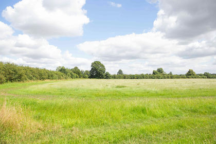
- Price
- Fixed Price£8,200
- Size
- 0.1 acres
Wallingford - Oxfordshire, Cholsey, Oxfordshire OX10 England
Added on 30/06/2026Small Plot of Land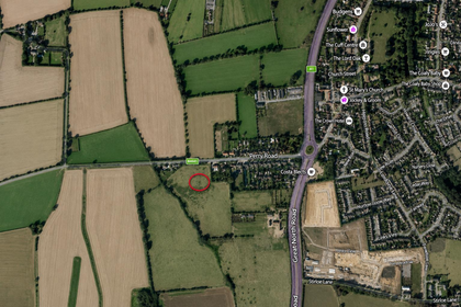
- Price
- Guide Price£5,000
Great North Road, Buckden, St. Neots, Wyboston, Chawston and Colesden, Bedford MK44 England
Added on 09/07/2026Vacant Land