Lordine Lane, Ewhurst Green, TN32
- Land size
- 3.77 acres
- Bedrooms
- 3
- Bathrooms
- 1
Key Features
- Grade II Listed Period Cottage
- Approximately 3.77 Acres Of Land
- Three Bedrooms With Character
- Stables And Equestrian Potential
- Detached Studio For Flexible Use
- Discreet Ground-Mounted Solar Panels
- Peaceful Ewhurst Green Countryside Setting
- Rural Lifestyle With Useful Connections
- Longstanding Family Ownership And Care
- Chain Free With Flexible Completion
Description
PRICE RANGE: £600,000 - £625,000
Watermans Cottage is the kind of home that reveals itself slowly. Arriving at the cottage, the setting immediately feels different: a historic home, open countryside, mature grounds and a sense of space that is increasingly difficult to find so close to established villages and useful local amenities.
The cottage has been in the same family for more than two decades, and that sense of having been genuinely lived in comes through. It is a three-bedroom semi-detached Grade II listed cottage, with the proportions, character and details you would expect from a 16th-century timber-framed home. It feels authentic rather than styled, with the warmth that comes from original character and years of being properly cared for.
Day to day, the appeal is as much outside as it is in. The property sits within approximately 3.77 acres, giving you room to garden, keep animals, pursue equestrian interests or simply enjoy having countryside around you. The stables add practical potential, while the detached studio creates a separate space for working from home, painting, making, exercising or having somewhere to retreat to when the house needs to remain the focus of family life.
The acreage also provides a thoughtful modern addition in the form of discreetly positioned solar panels, set within the grounds rather than mounted on the cottage roof. This means the historic roofline remains uncluttered, while the property can make use of its land to generate renewable energy. For a Grade II listed home, that is a particularly considered approach, combining the practical benefits of solar generation with respect for the character of the cottage and its setting.
There is also a useful flexibility to the land. For some, the attraction will be the equestrian potential. For others, it may be the opportunity to create a smallholding, grow more of their own produce or give children and dogs the freedom that comes with having this amount of private ground. The important thing is that the space can adapt as life changes.
The cottage itself has a natural warmth that works throughout the year. Summer brings long afternoons outside, with the garden and surrounding landscape becoming part of everyday life. In autumn, the outlook changes with the seasons, while winter brings a very different rhythm: returning home to a period cottage, drawing the curtains and settling in beside a roaring fire.
The setting is Ewhurst Green, a small East Sussex village where countryside is part of the everyday rather than something you drive to find. The White Dog Inn is close by, while Bodiam, Robertsbridge and Hawkhurst provide a wider range of shops, schools, services and places to eat. Bodiam Castle and Great Dixter are also part of the local landscape, with walks and country lanes leading out from the village.
For those commuting or needing to travel further afield, the wider road and rail connections make the rural setting practical as well as peaceful. Robertsbridge provides the nearest mainline railway connection, while the A21 gives access towards Tunbridge Wells, Hastings and beyond.
There is an honesty to Watermans Cottage that is hard to reproduce in a newer home. The Grade II listing protects much of its historic character, while the acreage, stables and studio give it the flexibility to support a very modern way of living. Whether your days involve working from home, keeping horses, spending time outdoors, entertaining friends or simply wanting more room around you, the property has space for those different rhythms.
What the sellers will leave behind is not simply a house, but a particular way of living: quiet mornings, changing seasons, open ground and the feeling of coming home to somewhere with a story of its own. That is perhaps what makes Watermans Cottage memorable.
Map Location
Property details
- Tenure
- Freehold
- Council Tax Band
- Ask Agent
- Date Posted
- 2026-09-24
Market Value Analysis
Compared with 1,844 Homes with Land listings in South East England (1+ acres).
Utilities & Restrictions
Utilities
- Electricity
- Ask Agent
- Water
- Ask Agent
- Heating
- Ask Agent
- Broadband
- Ask Agent
- Sewerage
- Ask Agent
Rights & Restrictions
- Public Rights of Way
- Ask Agent
- Private Rights of Way
- Ask Agent
- Listed Property
- Ask Agent
- Restrictions
- Ask Agent
Listed status, conservation areas and planning constraints for this location are in the full report.
Property Features
- Accessibility
- Ask Agent
- Parking
- Parking Available
- Garden
- Garden
Beyond the particulars: planning activity, flood history, heritage and ground risks, checked for this exact spot.
Connectivity
Broadband
Fastest speed available at this postcode
38 Mbps
Superfast · available to 12% of premises
Suitable for
- HD streaming
- Video calls
- Web & social
Mobile signal
Predicted 4G and 5G signal; indoor signal depends on building materials.
Ofcom Connected Nations postcode-level predictions. Speeds and signal are modelled, not measured, and vary between addresses and providers.
Signal is the easy part. Planning activity, flood history and protected designations here are in the full report.
Nearest Schools
Primary
- Staplecross Methodist Primary School1.1 milesOfsted: Good *
- Ages
- 4 to 11
- Pupils
- 88
- Type
- Voluntary controlled school
- Faith
- Methodist
- Bodiam Church of England Primary School1.4 milesOfsted: Good *
- Ages
- 4 to 11
- Pupils
- 85
- Type
- Voluntary controlled school
- Faith
- Church of England
- Northiam Church of England Primary School and Nursery2.2 milesNo Ofsted rating
- Ages
- 2 to 11
- Pupils
- 159
- Type
- Academy converter
- Faith
- Church of England
- Sandhurst Primary School2.8 milesNo Ofsted rating
- Ages
- 5 to 11
- Pupils
- 179
- Type
- Community school
- Brede Primary School3.3 milesOfsted report card · Mar 2026
- Ages
- 4 to 11
- Pupils
- 97
- Type
- Community school
Secondary
- Robertsbridge Community College4 milesOfsted: Inadequate
- Ages
- 11 to 16
- Pupils
- 644
- Type
- Academy sponsor led
- Claverham Community College6.2 milesNo Ofsted rating
- Ages
- 11 to 16
- Pupils
- 1,147
- Type
- Community school
- Cranbrook School7.6 milesOfsted report card · May 2026
- Ages
- 11 to 18
- Pupils
- 958
- Type
- Academy converter
- Faith
- Christian
- Ark Alexandra Academy7.7 milesOfsted report card · Jun 2026
- Ages
- 11 to 16
- Pupils
- 1,315
- Type
- Academy sponsor led
- Faith
- Church of England
- Mulberry Academy Hastings7.8 milesOfsted report card · Jan 2026
- Ages
- 11 to 16
- Pupils
- 833
- Type
- Academy sponsor led
* Latest graded judgement covers quality of education only; no overall grade was issued under the 2024-25 inspection framework.
Distances are straight-line from the advertised location. Source: the national school registers (DfE, Welsh Government, Scottish Government) and Ofsted.
Schools are just the start: sold prices nearby, planning activity and any flood history are in the full report.
Amenities
Supermarket
GP surgery
Pharmacy
Hospital
Green space
Straight-line distances from the advertised location. Sources: NHS records, Geolytix supermarket locations, OS Open Greenspace and the national trails registers.
The area stacks up? Now check the location itself: planning nearby, protected designations and past flooding.
Getting Around
Nearest station
Nearest bus stop
Typical drive times
Straight-line distances from the advertised location; drive times are typical free-flow times over OpenStreetMap road data, so allow more at peak. Public transport locations from DfT NaPTAN.
Easy to reach matters. So do planning activity, flood history and ground risks: all in the full report.
Flood Risk
Environment Agency open data, checked around the advertised map pin for the listed acreage. Long-term risk counts flood defences; the planning map's flood zones do not. Provided by LandSale, not the listing agent, and not part of the agent's particulars. Risk varies across a holding, so verify before committing.
Rivers and the sea
Planning map: Flood Zone 1.
Surface water
Not at the pin: mapped about 60 metres away.
These bandings are the summary. Where this location sits on the flood maps, plus planning activity, heritage and ground risks, is in the full report.
Important notice: Information, maps and tags on this page are drawn from the advertising agent's marketing materials or generated automatically. LandSale has not verified them. Relying on these details is at your own risk, always carry out independent checks before committing to a purchase.
LandSale full disclaimer
Marketing information only - not formal particulars. The details on this website are provided for general guidance and do not constitute an offer or contract. Neither LandSale nor the advertising estate/land agent accepts responsibility for any inaccuracy.
1. Source of information
- Listing content: Core description, asking price, tenure, measurements, photographs and planning history originate from the marketing materials of the advertising estate or land agent. LandSale does not author this content and cannot guarantee its accuracy.
- Automated tags & categorisation: Property type, land-use class, acreage bands and similar labels may be applied by machine-learning models. They are intended as a helpful guide only and may not reflect the property's legal status or permitted use.
- Third-party & enriched data layers: Maps, boundary outlines, planning designations, soil reports, broadband coverage and other environmental or location-based insights are licensed from external suppliers. Such data are supplied “as is", may be incomplete or out of date and are subject to change without notice.
2. Verification required
Prospective purchasers must verify critical matters, including but not limited to planning permission, title boundaries, public rights of way, environmental constraints, acreage, services, access and VAT status, through their own inspections, specialist surveys, legal advisers and the selling agent before relying on the information or entering into any contract.
3. No warranty or liability
LandSale gives no warranty, express or implied, as to the accuracy, completeness or fitness for any particular purpose of the information displayed. LandSale shall not be liable for any loss, damage, cost or expense arising directly or indirectly from any use of or reliance on such information, save where liability may not be excluded by law.
4. Updates & feedback
If you believe any detail on this listing is inaccurate, please let us know. We will investigate and, where appropriate, update the listing or notify the agent.
© LandSale | Version 1.3 - August 2026
Listing agent
TAUK, Covering Nationwide
Covering Nationwide
Similar properties for sale
- Price
- Offers in Excess of£700,000
- Size
- 27.39 acres
Added on 21/07/2026House with Land
- Price
- £675,000
- Size
- 1 acres
Rural Northiam, East Sussex TN31, Northiam, East Sussex TN31 England
Added on 21/05/2026Barn Conversion
- Price
- Offers in Excess of£600,000
- Size
- 1.25 acres
Vinehall Road, Mountfield, TN32, Mountfield, East Sussex TN32 England
Added on 10/06/2026House with Land
- Price
- £680,000
- Size
- 1.56 acres
69 Hastings Road, BATTLE, TN33, Battle, East Sussex TN33 England
Added on 23/04/2026House with Land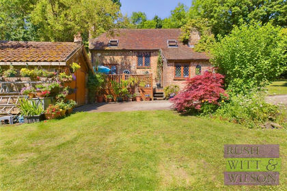
- Price
- £750,000
- Size
- 1 acres
Beauport Home Farm Close, St. Leonards-On-Sea, Hastings and Rye, East Sussex TN37 England
Added on 29/01/2026Cottage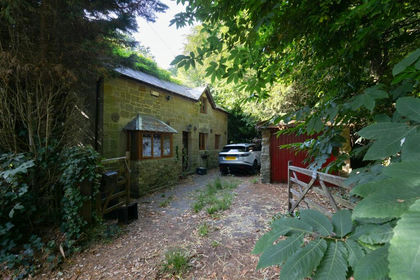
- Price
- Offers in Excess of£525,000
- Size
- 1.23 acres
Stonestile Lane, Hastings, Westfield, East Sussex TN35 England
Added on 23/07/2026Cottage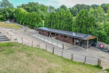
- Price
- £595,000
- Size
- 6 acres
Added on 06/02/2026Equestrian property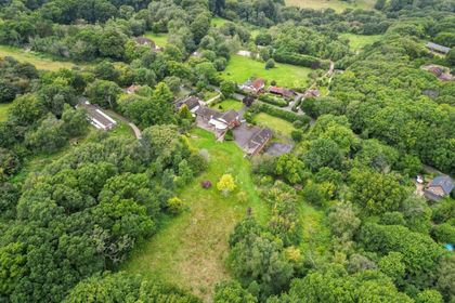
- Price
- £750,000
- Size
- 4.3 acres
Chowns Hill, Hastings, TN35, Guestling, East Sussex TN35 England
Added on 05/08/2026House with Land
- Price
- Guide Price£685,000
- Size
- 1 acres
Battery Hill, Fairlight, Hastings, Fairlight, East Sussex TN35 England
Added on 02/04/2026House with Land
- Price
- Offers in Region of£599,000
- Size
- 1 acres
Carricks Hill, Dallington, East Sussex, TN21, Dallington, East Sussex TN21 England
Added on 16/04/2026Cottage