Park Street Lane, St Albans, Hertfordshire, AL2
- Land size
- 6.74 acres
Description
SUMMARY
-The total site area is shown edged red and extends to approximately 2.46 hectares (6.74 acres).
-The site adjoins the settlement edge of How Wood, a village excluded from the Green Belt.
-A data room link provides a suite of document extracts, plans and planning summary.
LOCATION
-How Wood is a settlement between St Albans to the north and Watford to the south. It has a range of facilities and amenities together with transport links.
-How Wood is within - St Albans centre, 3 miles (4.5 km), Radlett centre, 2.2 miles (3.6 km), Watford centre 4 miles (6.6 km)
-Each of the above town centres has a main line railway stations St Pancras/ Euston.
-M1/M25 Junction 1.5 miles (2.2 km)
-The site has proximity via footpath access to the following -Neighbourhood centre, 0.9 km, Doctor's surgery, 0.55 km, Primary schools, 1 km, Secondary schools, 3.4 km, Bus stop outside the frontage with services 361 and 635
-Local railway stations (St Albans, Watford, Abbey Flyer) Bricketwood and How Wood, 0.8 km
All distances approximate.
THE SITE
The property is severed by the M25, which is in a cutting. The area of land north of the M25 is approximately 6 acres, and the area south 0.74 acres. This southern area adjoins an existing allotment and in the St Stephen Neighbourhood Plan it makes reference to the provision of additional allotments. The site is generally level and used for equestrian purposes. It fronts Park Street Lane an adopted public highway. Adjacent to the eastern boundary is the local railway line between St Albans and Watford Junction and a high pressure gas main. Beyond the railway line is a restored former waste tip site now used as a public accessible area. Along the southern boundary parallel to the M25 is a high pressure gas main which also crosses the land to the south.
Part of the site is shown on the Environment Agency website as being susceptible to flooding. Research indicates that there is a 9 inch diameter pipe beneath the railway line discharging into the brook. Areas of flooding provide opportunities for Biodiversity Net Gain or potentially to divert water via swales along the eastern boundary to a mitigation pond along the southern boundary and using site excess soil to provide a noise bund.
PLANNING OVERVIEW
The Site is within the Green Belt. The St Albans Local Plan was adopted on the 9 September. The Council are committed to an immediate review of the plan and have already started the process with a “call for sites”. The property has been submitted in the “call for sites”.
The housing provision in the Local Plan was based upon the old Standard Methodology. The new Standard Methodology requires a significant increase in the housing provision which will inevitably require the release of Green Belt.
The purpose of the Local Plan Review is to allocate land to meet the new housing requirements. St Albans Housing Delivery Test is at an estimated 45%.
The planning policies considered at the Local Plan Examination related to the National Planning Policy prior to the changes in December 2024 and the revisions to planning guidance in February 2025. The former introduced Grey Belt and the latter confirmed that for the Green Belt purposes, large settlements were not villages. How Wood is a village in the settlement hierarchy.
The National Planning Policy Framework August 2026 did not change Grey Belt and refers to the tilted balance in favour of sustainable development where the Housing Delivery Test was not met. Within Grey Belt development will be permitted in the Green Belt where there is an unmet development need. We believe there is a strong justification the land should be regarded as Grey Belt.
A summary of the Local Plan history and previous evidence is provided in the Information Pack. This shows the Councils have considered the property for housing in the past. As an edge of village settlement, the site has good proximity to services, amenities and public transport.
There is in our opinion a strong case for a Grey Belt planning application for housing and a robust case the site should be released from the Green Belt as part of the Local plan Review.
LEGAL TITLE
-The site is being marketed subject to and with the benefit of all wayleaves, easements, covenants and rights of way, whether or not disclosed.
-There are no known public rights of way over the site.
-The site is subject to a high pressure gas main, where its diversion was permitted under a temporary agreement when the M25 was constructed. There is no current formal wayleave or easement.
-The agreement in relation to the equestrian occupation is provided in the Information Pack.
VAT
The owners have not elected to charge VAT but reserve the right to opt to tax in relation to a Promotion Agreement.
TENURE AND POSSESSION
In respect of a sale of the property, the freehold interest with vacant possession on completion.
VIEWINGS
The site can be viewed from the public highway. Parties should take all due care for their own personal safety when inspecting the site.
INFORMATION PACK
An information pack is available upon request.
Interested parties will be deemed to have submitted proposals in the full knowledge of all the documents within the information pack. Documents included comprise:
-Legal title
-Grazing Agreement
-Temporary Gas Pipe Agreement and plan from Cadent.
-Submissions to the Reg 19 Local Plan Consultation - This provides a planning summary relating to the Local Plan history with extracts from planning documents.
-Environment Agency Flood Maps Fluvial and Surface Water.
-Overage Heads of Terms in respect of a sale.
-Bid Proforma for a Promotion Agreement.
SALE CONDITIONS
The sale will be subject to an overage provision of 40% of the enhanced value related to a planning change and for a period of 30 years. Details of the overage terms are provided within the information pack.
PROMOTION AGREEMENT
A Bid Pro Forma for completion of an offer in relation to a promotion agreement is provided in the information pack.
OFFERS
Offers for both the purchase and/or the promotion agreement should be clearly set out:
-confirm the information in the data room has been reviewed
-the proposed purchase price or completion of the promotion agreement pro forma
-full details of any conditions attached to the offer
BIDDING PROCESS
The sale and offers under a promotion agreement will be conducted by way of an informal tender. The proposal should be clearly marked ‘Land at Park Street, How Wood’ and should be submitted by e-mail to [email protected] by no later than 12 pm on Friday 27th o
Map Location
Property details
- Tenure
- Ask Agent
- Council Tax Band
- Ask Agent
- Date Posted
- 2026-09-22
Property Brochure
Seen the details? The full report adds the independent checks: planning activity, flood history, heritage and ground.
Utilities & Restrictions
Utilities
- Electricity
- Ask Agent
- Water
- Ask Agent
- Heating
- Ask Agent
- Broadband
- Ask Agent
- Sewerage
- Ask Agent
Rights & Restrictions
- Public Rights of Way
- Ask Agent
- Private Rights of Way
- Ask Agent
- Listed Property
- Ask Agent
- Restrictions
- Ask Agent
Listed status, conservation areas and planning constraints for this location are in the full report.
Property Features
- Accessibility
- Ask Agent
- Parking
- Ask Agent
- Garden
- Ask Agent
Beyond the particulars: planning activity, flood history, heritage and ground risks, checked for this exact spot.
Connectivity
Broadband
Fastest speed available at this postcode
1.8 Gbps
Gigabit full fibre
Suitable for
- 4K streaming on every screen
- Full-time home working
- Online gaming & big downloads
Mobile signal
Predicted 4G and 5G signal; indoor signal depends on building materials.
Ofcom Connected Nations postcode-level predictions. Speeds and signal are modelled, not measured, and vary between addresses and providers.
Signal is the easy part. Planning activity, flood history and protected designations here are in the full report.
Nearest Schools
Primary
- How Wood Primary and Nursery School0.7 milesOfsted: Good
- Ages
- 3 to 11
- Pupils
- 215
- Type
- Community school
- Park Street Church of England Voluntary Aided Primary School0.8 milesOfsted report card · May 2026
- Ages
- 3 to 11
- Pupils
- 153
- Type
- Voluntary aided school
- Faith
- Church of England
- Mount Pleasant Lane Primary School1.2 milesNo Ofsted rating
- Ages
- 3 to 11
- Pupils
- 200
- Type
- Academy converter
- Killigrew Primary and Nursery School1.4 milesNo Ofsted rating
- Ages
- 3 to 11
- Pupils
- 412
- Type
- Community school
- Coates Way JMI and Nursery School1.6 milesOfsted: Good *
- Ages
- 3 to 11
- Pupils
- 223
- Type
- Community school
Secondary
- Saint Michael's Catholic High School1.6 milesOfsted: Good *
- Ages
- 11 to 18
- Pupils
- 1,130
- Type
- Academy converter
- Faith
- Roman Catholic
- Parmiter's School1.7 milesOfsted: Outstanding
- Ages
- 11 to 18
- Pupils
- 1,496
- Type
- Academy converter
- The Marlborough Science Academy1.9 milesOfsted: Good
- Ages
- 11 to 18
- Pupils
- 1,337
- Type
- Academy converter
- Future Academies Watford1.9 milesOfsted: Good *
- Ages
- 11 to 18
- Pupils
- 1,060
- Type
- Academy sponsor led
- Samuel Ryder Academy2.6 milesOfsted report card · Apr 2026
- Ages
- 4 to 19
- Pupils
- 1,577
- Type
- Academy sponsor led
* Latest graded judgement covers quality of education only; no overall grade was issued under the 2024-25 inspection framework.
Distances are straight-line from the advertised location. Source: the national school registers (DfE, Welsh Government, Scottish Government) and Ofsted.
Schools are just the start: sold prices nearby, planning activity and any flood history are in the full report.
Amenities
Supermarket
GP surgery
Pharmacy
Hospital
Green space
Straight-line distances from the advertised location. Sources: NHS records, Geolytix supermarket locations, OS Open Greenspace and the national trails registers.
The area stacks up? Now check the location itself: planning nearby, protected designations and past flooding.
Getting Around
Nearest station
Nearest bus stop
Typical drive times
Straight-line distances from the advertised location; drive times are typical free-flow times over OpenStreetMap road data, so allow more at peak. Public transport locations from DfT NaPTAN.
Easy to reach matters. So do planning activity, flood history and ground risks: all in the full report.
Flood Risk
From Environment Agency flood map open data, checked around the advertised map pin and allowing for the listed acreage where known. This summary comes from LandSale, the advertising platform, not from the listing agent, and is not part of the agent's particulars. Risk can vary across a single holding, so verify anything critical through your own searches before committing.
Rivers and the sea
Also mapped within the area searched, about 90 metres around the pin: Flood Zone 2 from about 40 metres.
Medium risk nearbySurface water
Also mapped within the area searched, about 90 metres around the pin: a 1 in 100 to 1 in 1000 chance each year from about 40 metres.
Medium to low risk nearbyThese bandings are the summary. Where this location sits on the flood maps, plus planning activity, heritage and ground risks, is in the full report.
Important notice: Information, maps and tags on this page are drawn from the advertising agent's marketing materials or generated automatically. LandSale has not verified them. Relying on these details is at your own risk, always carry out independent checks before committing to a purchase.
LandSale full disclaimer
Marketing information only - not formal particulars. The details on this website are provided for general guidance and do not constitute an offer or contract. Neither LandSale nor the advertising estate/land agent accepts responsibility for any inaccuracy.
1. Source of information
- Listing content: Core description, asking price, tenure, measurements, photographs and planning history originate from the marketing materials of the advertising estate or land agent. LandSale does not author this content and cannot guarantee its accuracy.
- Automated tags & categorisation: Property type, land-use class, acreage bands and similar labels may be applied by machine-learning models. They are intended as a helpful guide only and may not reflect the property's legal status or permitted use.
- Third-party & enriched data layers: Maps, boundary outlines, planning designations, soil reports, broadband coverage and other environmental or location-based insights are licensed from external suppliers. Such data are supplied “as is", may be incomplete or out of date and are subject to change without notice.
2. Verification required
Prospective purchasers must verify critical matters, including but not limited to planning permission, title boundaries, public rights of way, environmental constraints, acreage, services, access and VAT status, through their own inspections, specialist surveys, legal advisers and the selling agent before relying on the information or entering into any contract.
3. No warranty or liability
LandSale gives no warranty, express or implied, as to the accuracy, completeness or fitness for any particular purpose of the information displayed. LandSale shall not be liable for any loss, damage, cost or expense arising directly or indirectly from any use of or reliance on such information, save where liability may not be excluded by law.
4. Updates & feedback
If you believe any detail on this listing is inaccurate, please let us know. We will investigate and, where appropriate, update the listing or notify the agent.
© LandSale | Version 1.3 - August 2026

Listing agent
Bidwells, Cambridge New Homes
54 High Street, Trumpington, Cambridge, CB2 9LS
Contact Bidwells, Cambridge New Homes
54 High Street, Trumpington, Cambridge, CB2 9LS
View agent profileSimilar properties for sale
- Price
- Offers in Excess of£210,000
- Size
- 12.17 acres
Added on 16/07/2026Farmland
- Price
- £195,000
- Size
- 7.3 acres
Little Gaddesden, Little Gaddesden, Hertfordshire HP4 England
Added on 08/09/2026Pasture
- Price
- Guide Price£500,000
- Size
- 5.28 acres
Mancroft Corner, Slip End, Bedfordshire, Slip End, Central Bedfordshire LU1 England
Added on 17/07/2026Vacant Land
- Price
- POA
- Size
- 71.38 acres
Land at Warrengate Farm, Panshanger, Hertfordshire, Tewin, Hertfordshire AL6 England
Added on 11/09/2026Agricultural Land
- Price
- POA
- Size
- 71.38 acres
Land At Warrengate Farm, Panshanger, Hertfordshire, AL6, Hertfordshire, Hertfordshire AL6 England
Added on 12/09/2026Arable Land
- Price
- Guide Price£195,000
- Size
- 5.04 acres
Barns View Paddock, Tring, Hertfordshire, Tring, Hertfordshire HP23 England
Added on 17/07/2026Vacant Land
- Price
- Guide Price£625,000
- Size
- 47.2 acres
LAND AT BREACH BARNS LANE Waltham Abbey, Essex, Waltham Abbey, Essex EN9 England
Added on 17/08/2026Undeveloped Land
- Price
- Offers in Excess of£249,995
- Size
- 4.5 acres
Added on 29/01/2026Development Land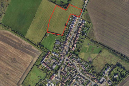
- Price
- Offers in Region of£1,250,000
- Size
- 4.4 acres
Added on 25/06/2026Development Land
- Price
- Guide Price£2,500,000
- Size
- 3.5 acres
Added on 20/07/2026Development Land