Land at Warrengate Farm, Panshanger, Hertfordshire
- Land size
- 71.38 acres
Key Features
- An attractive block of arable farmland
- Situated adjacent to land allocated for development at Welwyn Garden City
- Offering an accessible and well-located strategic land opportunity
- 71.38 ACRES (28.89 HECTARES)
- For sale by Private Treaty as a whole
Description
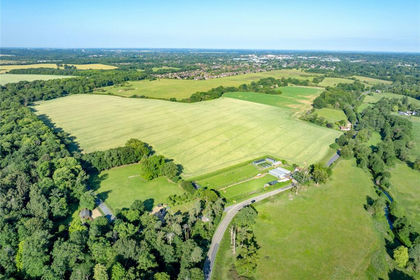
The sale of the land at Warrengate Farm presents an opportunity to acquire a strategically positioned block of productive agricultural land extending to approximately 71.38 acres (28.89 hectares). Situated at Panshanger on the eastern edge of Welwyn Garden City,
the land is predominantly arable and occupies a highly accessible location adjoining land allocated for development within the Welwyn Hatfield Local Plan.
The Land at Warrengate Farm extends to approximately 71.38 acres (28.89 hectares) and comprises two field parcels. The land is classified as Grade 3 agricultural land and is predominantly in arable production, together with an area of permanent pasture situated to the west, which benefits from separate access.
The soils comprise the Ludford Series, being deep, well-drained fine loamy, coarse loamy and sandy soils, locally flinty and in places over gravel. These versatile and productive soils are well suited to the cultivation of cereals and a wide range of other arable crops.
Environmental Schemes
The land is entered into a Countryside Stewardship Mid Tier Agreement which runs until 31 December 2027 and generates an annual income of approximately £7,247.14. The agreement is transferable to a purchaser in the event of a sale, subject to the relevant scheme requirements.
The land is also subject to a Sustainable Farming Incentive (SFI) Agreement expiring on 30 June 2027, which currently generates an income of approximately £2,668.43 per annum through the delivery of standard actions, including SAM1, IPM1 and NUM1. This agreement
is not transferable and would normally terminate upon a change of ownership. However, there may be opportunities for a purchaser to secure similar environmental income streams through participation in successor schemes or the implementation of alternative management arrangements.
Tenure & Possession
The land is currently farmed under a Farm Management Agreement, which is due to expire on 30 September 2026. The current operator has indicated a willingness to continue managing the land beyond this date, should a purchaser wish to retain the existing arrangements.
Vacant possession will be available on completion.
Method of Sale
The property is for sale as a whole by private treaty.
Planning
The land falls within the administrative area of East Hertfordshire District Council. The Council is currently preparing a new Local Plan, with consultation stages anticipated during 2026 and 2027 and adoption expected in the period 2027 to 2028. Land immediately to the south lies within the jurisdiction of Welwyn Hatfield Borough Council and is allocated for development under the adopted Local Plan. These allocations are now progressing through the planning and development process.
Designations
The land lies within the Green Belt.
The purchaser(s) will be deemed to have satisfied themselves of any planning matters affecting the property.
Overage
The property will be sold subject to an overage provision reserving the vendor 30% of any increase in value accruing over 25 years due to any development over and above the existing use value of the land, triggered by either implementation or a sale with the benefit
of planning permission. For the avoidance of doubt this will exclude any agricultural uses.
Further information is available on request from the selling agents.
Wayleaves, Easements & Rights of Way
The property is sold subject to, or with the benefit of, all existing wayleaves, easements, quasi-easements, rights of way, covenants and restrictions whether mentioned in these particulars or not.
A public footpath runs from the B1000, Hertford Road, south towards Panshanger Road. Section 31(6) deposits have been made in respect of both fields (completed in 2017) and are therefore valid for a period of 20 years.
The Purchaser(s) will be deemed to have full knowledge and will have satisfied themselves as to the provisions of any such matters affecting the property
Map Location
Property details
- Tenure
- Freehold
- Council Tax Band
- Ask Agent
- Date Posted
- 2026-09-11
Utilities & Restrictions
Utilities
- Electricity
- Ask Agent
- Water
- Ask Agent
- Heating
- Ask Agent
- Broadband
- Ask Agent
- Sewerage
- Ask Agent
Rights & Restrictions
- Public Rights of Way
- Ask Agent
- Private Rights of Way
- Ask Agent
- Listed Property
- Ask Agent
- Restrictions
- Ask Agent
Listed status, conservation areas and planning constraints for this location are in the full report.
Property Features
- Accessibility
- Ask Agent
- Parking
- Ask Agent
- Garden
- Ask Agent
Beyond the particulars: planning activity, flood history, heritage and ground risks, checked for this exact spot.
Connectivity
Broadband
Fastest speed available at this postcode
23 Mbps
Standard (10-30 Mbps)
Suitable for
- Web & social
- Music streaming
- Standard video calls
Mobile signal
Outdoor predictions; indoor signal depends on building materials.
Ofcom Connected Nations postcode-level predictions. Speeds and signal are modelled, not measured, and vary between addresses and providers.
Signal is the easy part. Planning activity, flood history and protected designations here are in the full report.
Nearest Schools
Primary
- Springmead Primary School955 metresOfsted: Good
- Ages
- 3 to 11
- Pupils
- 248
- Type
- Academy sponsor led
- Tewin Cowper Church of England Voluntary Aided Primary School0.7 milesOfsted: Requires improvement *
- Ages
- 4 to 11
- Pupils
- 122
- Type
- Voluntary aided school
- Faith
- Church of England
- Watchlytes Primary School0.9 milesOfsted report card · Dec 2025
- Ages
- 3 to 11
- Pupils
- 158
- Type
- Academy sponsor led
- Panshanger Primary School1.2 milesOfsted: Good
- Ages
- 3 to 11
- Pupils
- 240
- Type
- Community school
- The Holy Family Catholic Primary School1.2 milesNo Ofsted rating
- Ages
- 3 to 11
- Pupils
- 211
- Type
- Academy converter
- Faith
- Roman Catholic
Secondary
- Ridgeway Academy1 mileOfsted: Good *
- Ages
- 11 to 18
- Pupils
- 875
- Type
- Academy sponsor led
- The Sele School2.3 milesOfsted: Good *
- Ages
- 11 to 18
- Pupils
- 382
- Type
- Academy converter
- Monk's Walk School2.6 milesNo Ofsted rating
- Ages
- 11 to 18
- Pupils
- 1,440
- Type
- Academy converter
- Stanborough School2.9 milesOfsted: Good
- Ages
- 11 to 18
- Pupils
- 1,287
- Type
- Academy converter
- Richard Hale School3.5 milesOfsted: Good
- Ages
- 11 to 18
- Pupils
- 1,207
- Type
- Academy converter
- Gender
- Boys
* Latest graded judgement covers quality of education only; no overall grade was issued under the 2024-25 inspection framework.
Distances are straight-line from the advertised location. Source: the national school registers (DfE, Welsh Government, Scottish Government) and Ofsted.
Schools are just the start: sold prices nearby, planning activity and any flood history are in the full report.
Amenities
Supermarket
GP surgery
Pharmacy
Hospital
Green space
Straight-line distances from the advertised location. Sources: NHS records, Geolytix supermarket locations, OS Open Greenspace and the national trails registers.
The area stacks up? Now check the location itself: planning nearby, protected designations and past flooding.
Getting Around
Nearest station
Nearest bus stop
Typical drive times
Straight-line distances from the advertised location; drive times are typical free-flow times over OpenStreetMap road data, so allow more at peak. Public transport locations from DfT NaPTAN.
Easy to reach matters. So do planning activity, flood history and ground risks: all in the full report.
Flood Risk
From Environment Agency flood map open data, checked around the advertised map pin and allowing for the listed acreage where known. This summary comes from LandSale, the advertising platform, not from the listing agent, and is not part of the agent's particulars. Risk can vary across a single holding, so verify anything critical through your own searches before committing.
Rivers and the sea
Mapped within the area searched, not at the advertised map pin itself.
Surface water
Mapped within the area searched, not at the advertised map pin itself.
The detail behind these bandings
The full report pinpoints where this location sits on the flood maps, and runs the deeper checks that usually only surface after an offer.
- Exact flood zones & annual chances (included in the full report)
- Any recorded past flooding (included in the full report)
- Planning activity nearby (included in the full report)
- Heritage & conservation (included in the full report)
- Protected nature designations (included in the full report)
- Ground risks (included in the full report)
- Sold prices nearby (included in the full report)
£14.99 · one-off purchase
By LandSale, the platform. Not provided by the listing agent. Ready in about a minute.
Important notice: Information, maps and tags on this page are drawn from the advertising agent's marketing materials or generated automatically. LandSale has not verified them. Relying on these details is at your own risk, always carry out independent checks before committing to a purchase.
LandSale full disclaimer
Marketing information only - not formal particulars. The details on this website are provided for general guidance and do not constitute an offer or contract. Neither LandSale nor the advertising estate/land agent accepts responsibility for any inaccuracy.
1. Source of information
- Listing content: Core description, asking price, tenure, measurements, photographs and planning history originate from the marketing materials of the advertising estate or land agent. LandSale does not author this content and cannot guarantee its accuracy.
- Automated tags & categorisation: Property type, land-use class, acreage bands and similar labels may be applied by machine-learning models. They are intended as a helpful guide only and may not reflect the property's legal status or permitted use.
- Third-party & enriched data layers: Maps, boundary outlines, planning designations, soil reports, broadband coverage and other environmental or location-based insights are licensed from external suppliers. Such data are supplied “as is", may be incomplete or out of date and are subject to change without notice.
2. Verification required
Prospective purchasers must verify critical matters, including but not limited to planning permission, title boundaries, public rights of way, environmental constraints, acreage, services, access and VAT status, through their own inspections, specialist surveys, legal advisers and the selling agent before relying on the information or entering into any contract.
3. No warranty or liability
LandSale gives no warranty, express or implied, as to the accuracy, completeness or fitness for any particular purpose of the information displayed. LandSale shall not be liable for any loss, damage, cost or expense arising directly or indirectly from any use of or reliance on such information, save where liability may not be excluded by law.
4. Updates & feedback
If you believe any detail on this listing is inaccurate, please let us know. We will investigate and, where appropriate, update the listing or notify the agent.
© LandSale | Version 1.3 - August 2026
Listing agent
BRIGGS & STONE LIMITED, Prestwood
84 High Street, Prestwood, HP16 9ES
Similar properties for sale
- Price
- POA
- Size
- 71.38 acres
Land At Warrengate Farm, Panshanger, Hertfordshire, Welwyn Hatfield, Hertfordshire AL6 England
Added on 12/09/2026Agricultural Land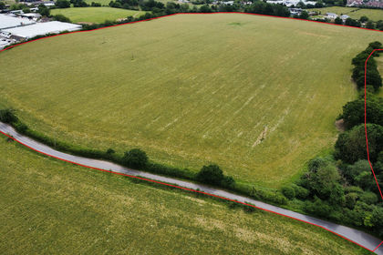
- Price
- Guide Price£625,000
- Size
- 47.2 acres
LAND AT BREACH BARNS LANE Waltham Abbey, Essex, Waltham Abbey, Essex EN9 England
Added on 17/08/2026Undeveloped Land
- Price
- Offers in Excess of£695,000
- Size
- 67 acres
Land at Cedar Farm, Cedar Farm, Bishop's Stortford, Great Hallingbury, Essex CM22 England
Added on 27/08/2026Farmland
- Price
- Guide Price£1,500,000
- Size
- 114.2 acres
Added on 03/07/2026Farmland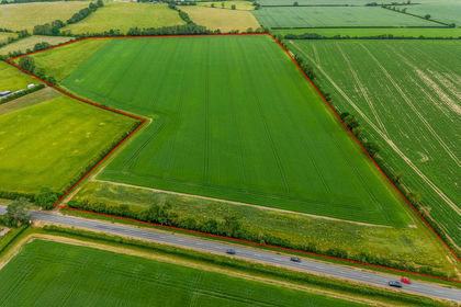
- Price
- Guide Price£525,000
- Size
- 38.28 acres
Land At Lower Road, Arrington, Royston, Cambridgeshire, Croydon, Cambridgeshire SG8 England
Added on 09/06/2026Arable Land
- Price
- Guide Price£6,325,000
- Size
- 643 acres
Added on 04/09/2026Farm
- Price
- Guide Price£5,850,000
- Size
- 593.62 acres
Added on 04/09/2026Farm
- Price
- Guide Price£475,000
- Size
- 49.8 acres
Added on 04/09/2026Arable Land
- Price
- Guide Price£2,375,000
- Size
- 220 acres
Willington, Bedford, Bedfordshire, Willington, Bedford MK44 England
Added on 15/07/2026Farm
- Price
- Guide Price£1,600,000
- Size
- 152.91 acres
Willington, Bedford, Bedfordshire, Willington, Bedford MK44 England
Added on 15/07/2026Farm