Development Opportunity - Hamstreet
- Land size
- 1.23 acres
Key Features
- ** DEVELOPMENT OPPERTUNITY **
- ** FULL PLANNING APPROVED FOR 7 DETACHED DWELLINGS **
- Strong GDV - Approx £4,000,000 +
- Access bridge constructed in readiness for site-completion
- 2 x 5 Bedroom Detached. 2 x 4 Bedroom Detached. 3 x 3 Bedroom Detached
- Semi-Rural Position with great road links to Tenterden & Ashford
- Site extending to approx 1.23acres (0.5 hectare)
- A Bespoke development in Hamstreet consisting of 7 detached Homes
- Electric Supply / Capacity already installed to site
- Viewings to be accompanied strictly by appointment only
Description
EXCEPTIONAL RESIDENTIAL DEVELOPMENT OPPORTUNITY – FULL PLANNING PERMISSION FOR SEVEN DWELLINGS
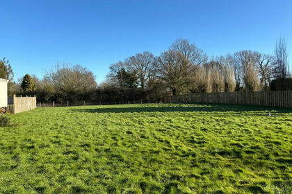
An exciting opportunity to acquire a strategically positioned residential development site with full planning permission for the construction of seven new homes, situated in an attractive semi-rural setting on the outskirts of the sought-after village of Hamstreet, Kent.
The approved scheme provides for an attractive and varied collection of traditionally designed family homes, comprising two substantial five-bedroom detached houses, two four-bedroom detached houses and three three-bedroom detached houses. The proposed development has been conceived to provide a more individual and distinctive character than that associated with conventional volume-built housing schemes, with the setting and architectural approach offering a Barn/Homestead-inspired character that responds particularly well to the rural surroundings.
The site occupies an appealing position adjoining the established Garden Centre and benefits from a combination of countryside character, excellent accessibility and proximity to a well-connected village community. Tenterden is within a short drive, whilst the larger commercial and transport centre of Ashford provides an extensive range of shopping, leisure, employment and educational facilities.
THE LOCATION
Hamstreet is a well-established and highly accessible village, offering a useful range of local amenities including a mainline railway station, primary school and nursery, doctor’s surgery with dispensing chemist, together with local shops and other day-to-day facilities. The village is also particularly well placed for access to the surrounding countryside, including the nearby woodland nature reserve.
The railway station provides regular services to Ashford International, where high-speed services reach London St Pancras in approximately 37 minutes, together with services towards Rye and Brighton.
The Access Bridge - The Bridge was designed to KCC & Drainage Board specifications. The agent does hold numerous design documents available for purchasers review.
Services - Electric: UKPN Document / plan – 500KVA transformer supply installed / sub-station on GC Land. Conduit in place for spur to housing development but UKPN will not run the cable until required / construction starting. Water Supply – Mains supply runs along Marsh Road so should be suitable to be connected to. Waste Water – Hamstreet Garden Centre. Waste Water drainage pipe runs up Marsh Road. It is believed there is a chamber near-by (Nearest to the village) of Hamstreet, this feeds to the gravity fed mains drainage system. We understand that a pumping station, like the Garden Centre uses, would be required for the development once constructed.
Covenants - Covenants - The following covenants apply, or will be applied to the sale:
1. There is a current right of way running along the boundary in favour of the land to the rear.
2. Overage – a 25% overage will be drawn up by the sellers conveyancer with regards to any further amendments to planning outline.
3. The buyer will have to covenant with the landowner and/ or purchaser of the adjacent lot to ensure planning conditions are fulfilled.
Offers are invited for the land as it stands with planning for 7 homes and consideration will be given to overage arrangements should further plots be consented too if the planning were to be revisited.
Management Company Status - It is recommended that the purchasers of the site should form a management company, which would be based on a fee (Per year) that all residents contribute too, to manage the shared facilities.
Right Of Access - The Garden Centre is to have occasional right of way over the bridge to rear service road and top of the car park area.
Current Title Plan - The current title plan is currently under-going separation. Interested parties will be able to request this in due course.
Site Requirements - Vehicle loading and unloading areas (construction and permanent)
Parking facilities including for visitors (construction and permanent)
Wheel washing (construction)
EV charging – one per house. Meeting minimum standards
Highway adoption and footpaths to this
Visibility splays must be maintained
Secure covered cycle parking must be provided
Drainage for both foul and surface
For those travelling by road, the A2070 provides convenient access towards the M20, including Junction 10, thereby offering strong connectivity to Ashford, the wider Kent region and the national motorway network.
THE DEVELOPMENT
The approved scheme comprises:
2 x Five-bedroom detached houses
2 x Four-bedroom detached houses
3 x Three-bedroom detached houses
Associated parking
Landscaping
Drainage infrastructure
Vehicular access from Marsh Road
The development presents the opportunity to create a carefully considered cluster of individual family homes, benefiting from its semi-rural setting and offering a markedly different proposition from the more conventional residential developments prevalent throughout the local area.
The previous buildings occupying the site have been removed, providing a clear development platform. A new access bridge has already been constructed and implemented, significantly advancing the site's infrastructure and reducing the initial development requirements for a prospective purchaser.
PLANNING & INFRASTRUCTURE
Full planning permission has been approved by Ashford Borough Council for the erection of seven dwellings together with associated parking, landscaping and drainage.
The planning consent provides an established framework for delivery of the scheme and offers prospective purchasers the opportunity to progress directly towards construction, subject to satisfying the relevant planning conditions.
The site's access arrangements have already been substantially progressed. Kent Highways have adopted the initial section of the access road from Marsh Road to the edge of the bridge/culvert, together with the initial section of the internal access towards the proposed residential development.
Further infrastructure works have also been undertaken in respect of the site's electricity supply. The electrical capacity serving the site has been upgraded, incorporating the anticipated requirements of the proposed residential development, with UK Power Networks having made provision for the supply to be brought forward to the location of the proposed homes.
Provision is also incorporated for electric vehicle charging, with one charging point to be provided per dwelling. The proposed EV charging infrastructure is required to comply with Mode 3 standards, providing charging of up to 7kW, together with SMART functionality enabling Wi-Fi connectivity.
DEVELOPMENT POTENTIAL
With planning permission secured, the principal infrastructure works already substantially progressed and the site cleared of its former buildings, this represents an increasingly rare opportunity to acquire a consented residential development site within an established and accessible Kent village.
The approved scheme provides a balanced mix of larger detached family homes, with the combination of generous accommodation, individual house types and a semi-rural setting likely to appeal to both private purchasers and the wider residential market.
Prospective purchasers should satisfy themselves as to the precise scope of the planning permission, all relevant conditions and the deliverability of the approved scheme. Interested parties are advised to make their own enquiries with Ashford Borough Council's Planning Department and relevant statutory authorities prior to submitting an offer.
Planning Reference: NOT/2025/2322
Further planning documentation, approved plans and supporting information are available upon request.
Map Location
Property details
- Tenure
- Freehold
- Council Tax Band
- Ask Agent
- Date Posted
- 2026-09-18
Market Value Analysis
Compared with 115 Development Land listings in South East England (1+ acres).
Utilities & Restrictions
Utilities
- Electricity
- Generator / Off-Grid
- Water
- Ask Agent
- Heating
- Ask Agent
- Broadband
- Ask Agent
- Sewerage
- Septic Tank / Private
Rights & Restrictions
- Public Rights of Way
- Yes
- Private Rights of Way
- Ask Agent
- Listed Property
- Ask Agent
- Restrictions
- Yes
Listed status, conservation areas and planning constraints for this location are in the full report.
Property Features
- Accessibility
- Ask Agent
- Parking
- Parking Available
- Garden
- Ask Agent
Beyond the particulars: planning activity, flood history, heritage and ground risks, checked for this exact spot.
Connectivity
Broadband
Fastest speed available at this postcode
1.8 Gbps
Superfast
Suitable for
- 4K streaming on every screen
- Full-time home working
- Online gaming & big downloads
Fixed wireless access may also be an option here.
Mobile signal
Outdoor predictions; indoor signal depends on building materials.
Ofcom Connected Nations postcode-level predictions. Speeds and signal are modelled, not measured, and vary between addresses and providers.
Signal is the easy part. Planning activity, flood history and protected designations here are in the full report.
Nearest Schools
Primary
- Hamstreet Primary Academy0.9 milesOfsted: Good
- Ages
- 4 to 11
- Pupils
- 222
- Type
- Academy converter
- Brenzett Church of England Primary School3.4 milesNo Ofsted rating
- Ages
- 4 to 11
- Pupils
- 90
- Type
- Academy sponsor led
- Faith
- Church of England
- Furley Park Primary Academy4 milesOfsted: Good *
- Ages
- 4 to 11
- Pupils
- 504
- Type
- Academy converter
- Woodchurch Church of England Primary School4.2 milesOfsted: Good
- Ages
- 4 to 11
- Pupils
- 165
- Type
- Voluntary controlled school
- Faith
- Church of England
- Brookland Church of England Primary School4.2 milesOfsted: Good
- Ages
- 4 to 11
- Pupils
- 94
- Type
- Voluntary controlled school
- Faith
- Church of England
Secondary
- The John Wallis Church of England Academy4.9 milesOfsted: Good
- Ages
- 3 to 19
- Pupils
- 1,650
- Type
- Academy sponsor led
- Faith
- Church of England
- Chilmington Green School5.4 milesOfsted report card · May 2026
- Ages
- 11 to 19
- Pupils
- 449
- Type
- Free schools
- The North School6.1 milesNo Ofsted rating
- Ages
- 11 to 19
- Pupils
- 1,237
- Type
- Academy converter
- The Marsh Academy6.2 milesOfsted: Good
- Ages
- 11 to 18
- Pupils
- 1,019
- Type
- Academy sponsor led
- The Norton Knatchbull School6.4 milesOfsted: Good
- Ages
- 11 to 18
- Pupils
- 1,348
- Type
- Academy converter
- Gender
- Boys
* Latest graded judgement covers quality of education only; no overall grade was issued under the 2024-25 inspection framework.
Distances are straight-line from the advertised location. Source: the national school registers (DfE, Welsh Government, Scottish Government) and Ofsted.
Schools are just the start: sold prices nearby, planning activity and any flood history are in the full report.
Amenities
Supermarket
GP surgery
Pharmacy
Hospital
Green space
Straight-line distances from the advertised location. Sources: NHS records, Geolytix supermarket locations, OS Open Greenspace and the national trails registers.
The area stacks up? Now check the location itself: planning nearby, protected designations and past flooding.
Getting Around
Nearest station
Nearest bus stop
Typical drive times
Straight-line distances from the advertised location; drive times are typical free-flow times over OpenStreetMap road data, so allow more at peak. Public transport locations from DfT NaPTAN.
Easy to reach matters. So do planning activity, flood history and ground risks: all in the full report.
Flood Risk
From Environment Agency flood map open data, checked around the advertised map pin and allowing for the listed acreage where known. This summary comes from LandSale, the advertising platform, not from the listing agent, and is not part of the agent's particulars. Risk can vary across a single holding, so verify anything critical through your own searches before committing.
Rivers and the sea
Surface water
These bandings are the summary. Where this location sits on the flood maps, plus planning activity, heritage and ground risks, is in the full report.
Important notice: Information, maps and tags on this page are drawn from the advertising agent's marketing materials or generated automatically. LandSale has not verified them. Relying on these details is at your own risk, always carry out independent checks before committing to a purchase.
LandSale full disclaimer
Marketing information only - not formal particulars. The details on this website are provided for general guidance and do not constitute an offer or contract. Neither LandSale nor the advertising estate/land agent accepts responsibility for any inaccuracy.
1. Source of information
- Listing content: Core description, asking price, tenure, measurements, photographs and planning history originate from the marketing materials of the advertising estate or land agent. LandSale does not author this content and cannot guarantee its accuracy.
- Automated tags & categorisation: Property type, land-use class, acreage bands and similar labels may be applied by machine-learning models. They are intended as a helpful guide only and may not reflect the property's legal status or permitted use.
- Third-party & enriched data layers: Maps, boundary outlines, planning designations, soil reports, broadband coverage and other environmental or location-based insights are licensed from external suppliers. Such data are supplied “as is", may be incomplete or out of date and are subject to change without notice.
2. Verification required
Prospective purchasers must verify critical matters, including but not limited to planning permission, title boundaries, public rights of way, environmental constraints, acreage, services, access and VAT status, through their own inspections, specialist surveys, legal advisers and the selling agent before relying on the information or entering into any contract.
3. No warranty or liability
LandSale gives no warranty, express or implied, as to the accuracy, completeness or fitness for any particular purpose of the information displayed. LandSale shall not be liable for any loss, damage, cost or expense arising directly or indirectly from any use of or reliance on such information, save where liability may not be excluded by law.
4. Updates & feedback
If you believe any detail on this listing is inaccurate, please let us know. We will investigate and, where appropriate, update the listing or notify the agent.
© LandSale | Version 1.3 - August 2026
Listing agent
Hunters, Tenterden
102 High Street, Tenterden, Kent, TN30 6HT
Similar properties for sale
- Price
- £1,300,000
- Size
- 4.9 acres
Redbrook Street, Woodchurch, Ashford, TN26, Woodchurch, Kent TN26 England
Added on 29/01/2026Development Land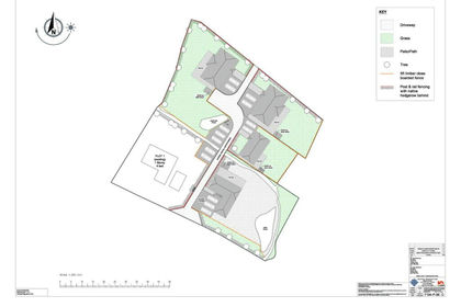
- Price
- £1,100,000
Church Hill, Charing Heath, TN27, Charing, Kent TN27 England
Added on 28/05/2026Development Land
- Price
- £1,525,000
Added on 29/01/2026Development Land
- Price
- £1,400,000
Added on 17/07/2026Development Land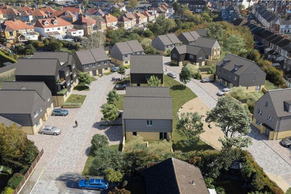
- Price
- Offers in Region of£1,750,000
- Size
- 2.25 acres
Moat Farm Road, Folkestone, Kent, CT19, Folkestone, Kent CT19 England
Added on 29/01/2026Development Land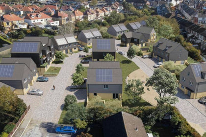
- Price
- £1,750,000
- Size
- 2.25 acres
Moat Farm Road, Folkestone, CT19, Folkestone, Kent CT19 England
Added on 28/01/2026Development Land
- Price
- £1,100,000
- Size
- 1.41 acres
Chequers Hill, Doddington, Sittingbourne, Kent, ME9, Doddington, Kent ME9 England
Added on 30/04/2026Development Land
- Price
- Offers in Region of£1,500,000
- Size
- 11 acres
Added on 05/04/2026Development Land
- Price
- Guide Price£1,275,000
- Size
- 36 acres
Cannon Farm Buildings and Land, Thorn Road, Marden, Marden, Kent TN12 England
Added on 29/01/2026Farm
- Price
- Guide Price£1,500,000
Boughton Monchelsea, Maidstone, Boughton Monchelsea, Kent ME17 England
Added on 09/06/2026Development Land