Romney Road, Lydd, Romney Marsh, Kent, TN29
- Land size
- 1 acres
- Bedrooms
- 3
- Bathrooms
- 1
Key Features
- Approximately one acre of land including garden and paddock
- Additional 0.6-acre Lot 2 available separately for £50,000
- Excellent potential for alternative use or redevelopment, subject to planning
- Detached family home on the outskirts of historic Lydd
- Well-presented throughout with several recent upgrades
- New windows and doors, modern kitchen and bathroom
- Paddock with independent access via a farm track/right of way
- Lot 2 includes a disused greenhouse/nursery, static caravan and double garage
Description
A good village home with an acre of land and further land available by separate negotiation. -- Greg Wood, Director
#TheGardenOfEngland
A detached family home situated on the outskirts of the village of Lydd, presented for sale in good order with several recent upgrades, including new windows and doors, sturdy fencing to the boundaries, and a modern kitchen and bathroom. The property is offered with approximately one acre of land, comprising a regular rear garden together with a paddock.
A separate Lot 2 is also available for a further £50,000 guide price comprising the additional land approximately 0.6 acre to the side of the property.
As the photographs show, the house is in excellent order and represents a rare opportunity to acquire a family home with the bonus of a paddock, including independent access (right of way) via a farm track just along the road. This is marked on the land plan provided. The paddock has been grazed by horses and sheep for many years.
Lot 2, available separately, is a now-disused greenhouse/nursery, a static caravan and a detached double garage. The static caravan has been in situ since 2018 and replaced previous versions which are understood to have been on the site and in continuous use since at least 2001.
The greenhouse/nursery and associated land offer excellent potential for redevelopment or alternative use, subject to obtaining the necessary planning permissions and consents.
Footpaths/Riding
There are no footpaths or other public rights of way crossing the land. There is a Public Footpath along the track (marked in our plan) that provides vehicular access to the rear paddock.
For further information go to:
Plan/Acreage/Boundaries
Any plans used are published for illustrative purposes only and although they are believed to be correct their accuracy cannot be guaranteed.
Planning
All enquiries relating to any further planning matters should be referred to the planning department at Folkestone and Hythe District Council.
Land Categorisation
We believe the land at the end of the boundary of the residential garden(s) to be classified as SSSI - a Site of Special Scientific Interest. Further details are available here:
Situation
Lydd, a historic town in Kent, sits at the heart of the stunning Romney Marsh, a unique and tranquil landscape of wide open spaces, wetlands, and rich wildlife. The town has a quiet, rural charm and is close to some of the county’s most distinctive natural attractions.
Lydd offers good road connectivity, with the A259 nearby providing links to Rye, Hastings, and Folkestone, while the M20 is about a 30-minute drive away for access to London and the Eurotunnel. Although there is no direct train station in Lydd, nearby stations like Rye and Ashford International offer convenient rail connections to London and Europe.
The coastline is one of Lydd’s major draws, with Dungeness beach just a short drive away. This shingle beach, known for its dramatic, otherworldly landscape, is popular with nature lovers and photographers. Further along the coast, you'll find more traditional seaside towns like New Romney and Camber Sands.
Overall, Lydd offers a peaceful, close-knit community vibe, with an emphasis on nature and a slower pace of life, making it ideal for those looking to escape the bustle of larger towns and cities.
Additional Information
Services
Mains water supply
Mains drainage
Heating – Gas central heating
Mains electricity
Council Tax (existing property) – Band C
Tenure – Freehold
Flood Risk – Very Low*
Broadband – Yes. Ultrafast available*
Mobile Signal Coverage – Yes*
Data taken from Sprift via On The Market.
Our Ref: AVS240032
Map Location
Property details
- Tenure
- Freehold
- Council Tax Band
- TBC
- Date Posted
- 2026-09-18
Market Value Analysis
Compared with 1,937 Homes with Land listings in South East England (1+ acres).
Utilities & Restrictions
Utilities
- Electricity
- Ask Agent
- Water
- Ask Agent
- Heating
- Ask Agent
- Broadband
- Ask Agent
- Sewerage
- Ask Agent
Rights & Restrictions
- Public Rights of Way
- Ask Agent
- Private Rights of Way
- Ask Agent
- Listed Property
- Ask Agent
- Restrictions
- Ask Agent
Listed status, conservation areas and planning constraints for this location are in the full report.
Property Features
- Accessibility
- Ask Agent
- Parking
- Parking Available
- Garden
- Garden
Beyond the particulars: planning activity, flood history, heritage and ground risks, checked for this exact spot.
Connectivity
Broadband
Fastest speed available at this postcode
1 Gbps
Gigabit full fibre · available to 86% of premises
Suitable for
- 4K streaming on every screen
- Full-time home working
- Online gaming & big downloads
Fixed wireless access may also be an option here.
Mobile signal
Outdoor predictions; indoor signal depends on building materials.
Ofcom Connected Nations postcode-level predictions. Speeds and signal are modelled, not measured, and vary between addresses and providers.
Signal is the easy part. Planning activity, flood history and protected designations here are in the full report.
Nearest Schools
Primary
- Lydd Primary School0.8 milesNo Ofsted rating
- Ages
- 3 to 11
- Pupils
- 230
- Type
- Academy sponsor led
- Greatstone Primary School1.8 milesOfsted: Good
- Ages
- 2 to 11
- Pupils
- 215
- Type
- Foundation school
- St Nicholas Church of England Primary Academy2.4 milesNo Ofsted rating
- Ages
- 4 to 11
- Pupils
- 412
- Type
- Academy sponsor led
- Faith
- Church of England
- Brenzett Church of England Primary School4.3 milesNo Ofsted rating
- Ages
- 4 to 11
- Pupils
- 90
- Type
- Academy sponsor led
- Faith
- Church of England
- Brookland Church of England Primary School4.5 milesOfsted: Good
- Ages
- 4 to 11
- Pupils
- 94
- Type
- Voluntary controlled school
- Faith
- Church of England
Secondary
- The Marsh Academy2.4 milesOfsted: Good
- Ages
- 11 to 18
- Pupils
- 1,019
- Type
- Academy sponsor led
- Rye College8.1 milesOfsted: Good
- Ages
- 11 to 16
- Pupils
- 645
- Type
- Academy converter
- Brockhill Park Performing Arts College11 milesOfsted report card · Jan 2026
- Ages
- 11 to 18
- Pupils
- 1,314
- Type
- Academy converter
- The John Wallis Church of England Academy12 milesOfsted: Good
- Ages
- 3 to 19
- Pupils
- 1,650
- Type
- Academy sponsor led
- Faith
- Church of England
- Chilmington Green School13 milesOfsted report card · May 2026
- Ages
- 11 to 19
- Pupils
- 449
- Type
- Free schools
Distances are straight-line from the advertised location. Source: the national school registers (DfE, Welsh Government, Scottish Government) and Ofsted.
Schools are just the start: sold prices nearby, planning activity and any flood history are in the full report.
Amenities
Supermarket
GP surgery
Pharmacy
Hospital
Green space
Straight-line distances from the advertised location. Sources: NHS records, Geolytix supermarket locations, OS Open Greenspace and the national trails registers.
The area stacks up? Now check the location itself: planning nearby, protected designations and past flooding.
Getting Around
Nearest station
Nearest bus stop
Typical drive times
Straight-line distances from the advertised location; drive times are typical free-flow times over OpenStreetMap road data, so allow more at peak. Public transport locations from DfT NaPTAN.
Easy to reach matters. So do planning activity, flood history and ground risks: all in the full report.
Flood Risk
From Environment Agency flood map open data, checked around the advertised map pin and allowing for the listed acreage where known. This summary comes from LandSale, the advertising platform, not from the listing agent, and is not part of the agent's particulars. Risk can vary across a single holding, so verify anything critical through your own searches before committing.
Rivers and the sea
Surface water
These bandings are the summary. Where this location sits on the flood maps, plus planning activity, heritage and ground risks, is in the full report.
Important notice: Information, maps and tags on this page are drawn from the advertising agent's marketing materials or generated automatically. LandSale has not verified them. Relying on these details is at your own risk, always carry out independent checks before committing to a purchase.
LandSale full disclaimer
Marketing information only - not formal particulars. The details on this website are provided for general guidance and do not constitute an offer or contract. Neither LandSale nor the advertising estate/land agent accepts responsibility for any inaccuracy.
1. Source of information
- Listing content: Core description, asking price, tenure, measurements, photographs and planning history originate from the marketing materials of the advertising estate or land agent. LandSale does not author this content and cannot guarantee its accuracy.
- Automated tags & categorisation: Property type, land-use class, acreage bands and similar labels may be applied by machine-learning models. They are intended as a helpful guide only and may not reflect the property's legal status or permitted use.
- Third-party & enriched data layers: Maps, boundary outlines, planning designations, soil reports, broadband coverage and other environmental or location-based insights are licensed from external suppliers. Such data are supplied “as is", may be incomplete or out of date and are subject to change without notice.
2. Verification required
Prospective purchasers must verify critical matters, including but not limited to planning permission, title boundaries, public rights of way, environmental constraints, acreage, services, access and VAT status, through their own inspections, specialist surveys, legal advisers and the selling agent before relying on the information or entering into any contract.
3. No warranty or liability
LandSale gives no warranty, express or implied, as to the accuracy, completeness or fitness for any particular purpose of the information displayed. LandSale shall not be liable for any loss, damage, cost or expense arising directly or indirectly from any use of or reliance on such information, save where liability may not be excluded by law.
4. Updates & feedback
If you believe any detail on this listing is inaccurate, please let us know. We will investigate and, where appropriate, update the listing or notify the agent.
© LandSale | Version 1.3 - August 2026
Listing agent
Hobbs Parker Estate Agents, Ashford
Romney House Monument Way, Orbital Park, Ashford, TN24 0HB
Contact Hobbs Parker Estate Agents, Ashford
Romney House Monument Way, Orbital Park, Ashford, TN24 0HB
View agent profileSimilar properties for sale
- Price
- Guide Price£475,000
- Size
- 0.77 acres
Added on 29/01/2026Building Plot
- Price
- Offers in Region of£350,000
Development Opportunity - Dymchurch, Dymchurch, Kent TN29 England
Added on 07/06/2026Building Plot Added on 12/07/2026Cottage
- Price
- Offers in Excess of£400,000
- Size
- 0.42 acres
Added on 22/05/2026Development Land
- Price
- Offers in Region of£450,000
Added on 11/08/2026Development Land
- Price
- Guide Price£345,000
- Size
- 0.25 acres
Building plot at, Donsmead Drive, Northiam, Rye, East Sussex TN31 England
Added on 23/07/2026Building Plot
- Price
- Offers in Excess of£350,000
Shirley Drive, St. Leonards-On-Sea, Hastings and Rye, East Sussex TN37 England
Added on 29/01/2026Building Plot
- Price
- Offers in Excess of£500,000
- Size
- 14.86 acres
Grooms Cottage & Old Stables Cottage & Vineyard, Dover, CT15, Alkham, Kent CT15 England
Added on 29/01/2026Vineyard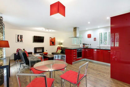
- Price
- Offers in Excess of£500,000
- Size
- 14.86 acres
Lot 2 - Holiday Lets & Vineyard - Alkham, CT15, Alkham, Kent CT15 England
Added on 29/01/2026Multiple Dwelling Property
- Price
- £450,000
Added on 19/02/2026Development Land