The Street, Ashwellthorpe
- Land size
- 0.36 acres
- Bedrooms
- 4
- Bathrooms
- 2
Key Features
- Beautifully presented barn conversion extending to approximately 1,705 sq/ft
- 3 ground floor bedrooms, with 2 enjoying their own private staircases leading to individual en-suites
- Versatile 4th bedroom/dressing room or study with fitted storage
- Spectacular 47'10 open-plan living area to the heart of the home with vaulted ceilings, exposed beams and an abundance of character
- Inviting lounge area centred around a feature multi-fuel burner, creating a cosy contrast to the impressive open-plan proportions
- Stylish kitchen and dining area designed for entertaining, with integrated appliances, generous work surfaces and a breakfast bar
- Air source heat pump, ground floor underfloor heating and double glazing
- Set within a plot of approx. 0.36 acres with an expansive lawn, established planting and excellent outdoor entertaining spaces
- Attractive rear courtyard-style garden providing a more private, low-maintenance setting for dining and relaxing
- Gated off-road parking for multiple vehicles together with a substantial double garage featuring an electric roller door
Description
DRAFT DETAILS AWAITING APPROVAL
SUMMARY
This beautifully presented barn conversion brings together the proportions and architectural character of its agricultural origins with an inviting contemporary interior.
The open-plan living space is undoubtedly the defining feature. Extending to an impressive 47'10, the room stretches through living, dining and kitchen areas beneath a dramatic vaulted ceiling, where exposed timber trusses give the space its unmistakable character. At one end, the inviting sitting area centres around a feature multi-fuel burner, while the modern kitchen occupies the heart of the room with integrated appliances and a sociable breakfast bar. Beyond, the dining area provides a wonderful setting for everyday meals and entertaining.
A separate utility room and WC sit conveniently alongside, while the bedroom accommodation provides considerable versatility. There are 3 bedrooms plus a 4th bedroom currently arranged as a dressing room with fitted storage. 2 bedrooms have the particularly unusual benefit of their own staircase rising to a private en-suite.
Altogether, the accommodation offers an impressive blend of character, space and versatility, with a thoughtful layout perfectly suited to both everyday living and entertaining.
OUTSIDE
Set discreetly along a private drive, the grounds provide an attractive extension of the living accommodation. The approach leads to a gated driveway capable of accommodating multiple vehicles, alongside a double garage with electric roller door.
To the front, a broad lawn is framed by mature hedging and established planting, with a secluded decked seating area nestled amongst the garden. While the rear is a contrasting courtyard-style garden, paved to provide plenty of room for dining and seating. Together, the gardens, parking and approx. 0.36 acre plot (STMS) give this character home an excellent balance of space and practicality.
LOCATION
Ashwellthorpe is a peaceful South Norfolk village surrounded by attractive countryside, offering a relaxed rural lifestyle within easy reach of nearby towns. Around 4 miles south-east of Wymondham, the village has a strong community feel, with local facilities and beautiful countryside including Lower Wood, known for its ancient woodland and spring bluebells. Wymondham provides a great choice of shops, supermarkets, cafés, schools and leisure facilities, along with rail services and easy access to the A11. Norwich is approximately 12 miles away, making Ashwellthorpe ideal for those seeking village life with excellent connections.
DIRECTIONS
Leave Wymondham via Silfield Road towards the village of Ashwellthorpe and continue on this road as it becomes The Street in the village. The property can be found down a private road on the right-hand side.
AGENTS NOTE
Please be advised a planning application has been made within the area.
LOCAL AUTHORITY
South Norfolk
COUNCIL TAX BAND
D
DISCLAIMER
While we have made diligent efforts to ensure the accuracy of the information relating to each property at the point of listing, you are advised to consult the official local council website for details on conservation areas, flood risks, tree preservation orders, planning applications, and other relevant aspects. These details are for guidance purposes only and we do not seek advice from the seller's legal representative in their preparation. We also strongly advise that you inspect the property and surrounding area on Google Maps and Street View prior to viewing. The photographs do not infer that items shown are included in the sale, the measurements quoted are approximate and the fixtures, fittings and appliances have not been tested, therefore no guarantee can be given that they are in working order. If there is any point which is of particular importance to you then please obtain professional confirmation of it.
GDPR
Should you wish to view one of our properties, we will require certain pieces of personal information from you in order to provide a professional service to you and our client, the seller. The personal information you provide to us will be shared with the seller, but it will not be shared with any other third parties without your consent.
Should you wish to proceed and make an offer on a property, some of the personal information you provide to us will be passed to the seller. Again, it will not be shared with any other third parties without your consent.
More information on how we hold and process your data is available upon request or on our website.
LETTINGS SERVICES
We offer a professional, ARLA accredited Lettings and Management Service via our affiliated agency, Habi Property. If you are considering renting your property in order to purchase, are looking at buy to let or would like a free, no obligation review of your current portfolio then please contact the office to discuss this further.
Map Location
Property details
- Tenure
- Freehold
- Council Tax Band
- D
- Date Posted
- 2026-09-14
Energy Performance Certificate
Energy Efficiency Rating
Based on UK Energy Performance Certificate standards (EU Directive 2002/91/EC)
View official EPC certificate ↗
Running costs are one side. Planning activity, flood history and ground risks for this location are in the full report.
Utilities & Restrictions
Utilities
- Electricity
- Ask Agent
- Water
- Ask Agent
- Heating
- Air Source Heat Pump, Underfloor Heating
- Broadband
- Ask Agent
- Sewerage
- Ask Agent
Rights & Restrictions
- Public Rights of Way
- Ask Agent
- Private Rights of Way
- Ask Agent
- Listed Property
- Ask Agent
- Restrictions
- Ask Agent
Listed status, conservation areas and planning constraints for this location are in the full report.
Property Features
- Accessibility
- Ask Agent
- Parking
- Garage, Driveway
- Garden
- Garden
Beyond the particulars: planning activity, flood history, heritage and ground risks, checked for this exact spot.
Connectivity
Broadband
Fastest speed available at this postcode
1.8 Gbps
Gigabit full fibre · available to 4% of premises
Suitable for
- 4K streaming on every screen
- Full-time home working
- Online gaming & big downloads
Mobile signal
Outdoor predictions; indoor signal depends on building materials.
Ofcom Connected Nations postcode-level predictions. Speeds and signal are modelled, not measured, and vary between addresses and providers.
Signal is the easy part. Planning activity, flood history and protected designations here are in the full report.
Nearest Schools
Primary
- Wreningham VC Primary School1.4 milesOfsted: Good *
- Ages
- 4 to 11
- Pupils
- 108
- Type
- Voluntary controlled school
- Faith
- Church of England
- Tacolneston Church of England Primary Academy1.6 milesNo Ofsted rating
- Ages
- 4 to 11
- Pupils
- 70
- Type
- Academy converter
- Faith
- Church of England
- Silfield Oak Primary Academy2.2 milesNo Ofsted rating
- Ages
- 4 to 11
- Pupils
- 30
- Type
- Free schools
- Hapton Church of England Voluntary Aided Primary School2.4 milesOfsted report card · Apr 2026
- Ages
- 4 to 11
- Pupils
- 18
- Type
- Voluntary aided school
- Faith
- Church of England
- Spooner Row Primary School2.8 milesOfsted report card · Feb 2026
- Ages
- 4 to 11
- Pupils
- 107
- Type
- Academy converter
Secondary
- Wymondham High Academy3.1 milesNo Ofsted rating
- Ages
- 11 to 18
- Pupils
- 1,686
- Type
- Academy converter
- Wymondham College4 milesOfsted: Outstanding
- Ages
- 11 to 18
- Pupils
- 1,427
- Type
- Academy converter
- Long Stratton High School4.6 milesOfsted report card · Feb 2026
- Ages
- 11 to 16
- Pupils
- 679
- Type
- Academy sponsor led
- Hethersett Academy4.7 milesNo Ofsted rating
- Ages
- 11 to 16
- Pupils
- 1,250
- Type
- Academy sponsor led
- Attleborough Academy5.6 milesOfsted report card · Mar 2026
- Ages
- 11 to 18
- Pupils
- 976
- Type
- Academy converter
* Latest graded judgement covers quality of education only; no overall grade was issued under the 2024-25 inspection framework.
Distances are straight-line from the advertised location. Source: the national school registers (DfE, Welsh Government, Scottish Government) and Ofsted.
Schools are just the start: sold prices nearby, planning activity and any flood history are in the full report.
Amenities
Supermarket
GP surgery
Pharmacy
Hospital
Green space
Straight-line distances from the advertised location. Sources: NHS records, Geolytix supermarket locations, OS Open Greenspace and the national trails registers.
The area stacks up? Now check the location itself: planning nearby, protected designations and past flooding.
Getting Around
Nearest station
Nearest bus stop
Typical drive times
Straight-line distances from the advertised location; drive times are typical free-flow times over OpenStreetMap road data, so allow more at peak. Public transport locations from DfT NaPTAN.
Easy to reach matters. So do planning activity, flood history and ground risks: all in the full report.
Flood Risk
From Environment Agency flood map open data, checked around the advertised map pin and allowing for the listed acreage where known. This summary comes from LandSale, the advertising platform, not from the listing agent, and is not part of the agent's particulars. Risk can vary across a single holding, so verify anything critical through your own searches before committing.
Rivers and the sea
Surface water
These bandings are the summary. Where this location sits on the flood maps, plus planning activity, heritage and ground risks, is in the full report.
Important notice: Information, maps and tags on this page are drawn from the advertising agent's marketing materials or generated automatically. LandSale has not verified them. Relying on these details is at your own risk, always carry out independent checks before committing to a purchase.
LandSale full disclaimer
Marketing information only - not formal particulars. The details on this website are provided for general guidance and do not constitute an offer or contract. Neither LandSale nor the advertising estate/land agent accepts responsibility for any inaccuracy.
1. Source of information
- Listing content: Core description, asking price, tenure, measurements, photographs and planning history originate from the marketing materials of the advertising estate or land agent. LandSale does not author this content and cannot guarantee its accuracy.
- Automated tags & categorisation: Property type, land-use class, acreage bands and similar labels may be applied by machine-learning models. They are intended as a helpful guide only and may not reflect the property's legal status or permitted use.
- Third-party & enriched data layers: Maps, boundary outlines, planning designations, soil reports, broadband coverage and other environmental or location-based insights are licensed from external suppliers. Such data are supplied “as is", may be incomplete or out of date and are subject to change without notice.
2. Verification required
Prospective purchasers must verify critical matters, including but not limited to planning permission, title boundaries, public rights of way, environmental constraints, acreage, services, access and VAT status, through their own inspections, specialist surveys, legal advisers and the selling agent before relying on the information or entering into any contract.
3. No warranty or liability
LandSale gives no warranty, express or implied, as to the accuracy, completeness or fitness for any particular purpose of the information displayed. LandSale shall not be liable for any loss, damage, cost or expense arising directly or indirectly from any use of or reliance on such information, save where liability may not be excluded by law.
4. Updates & feedback
If you believe any detail on this listing is inaccurate, please let us know. We will investigate and, where appropriate, update the listing or notify the agent.
© LandSale | Version 1.3 - August 2026
Listing agent
Hammond & Stratford, Hethersett
28 Great Melton Road, Hethersett, NR9 3AB
Similar properties for sale
- Price
- Fixed Price£665,000
- Size
- 1 acres
Oak Lodge, Norwich Road, Ashwellthorpe, Ashwellthorpe and Fundenhall, Norfolk NR16 England
Added on 29/01/2026House with Land
- Price
- Offers in Excess of£595,000
- Size
- 0.5 acres
Norwich Road, Tacolneston, Tacolneston, Norfolk NR16 England
Added on 29/01/2026Development Land
- Price
- Guide Price£700,000
- Size
- 1.09 acres
West Road, Forncett St. Peter, Norwich, Forncett, Norfolk NR16 England
Added on 05/08/2026House with Land
- Price
- Guide Price£650,000
- Size
- 2.3 acres
Low Road, Forncett St. Peter, Norwich, Forncett, Norfolk NR16 England
Added on 08/09/2026House with Land
- Price
- Guide Price£650,000
- Size
- 2 acres
Added on 08/09/2026Farmhouse
- Price
- Guide Price£700,000
- Size
- 1.52 acres
Added on 16/05/2026House with Land Added on 24/06/2026Barn Conversion
- Price
- £555,000
- Size
- 1 acres
Cairn Lodge, Woodrow Lane, Great Moulton, Norwich, Norfolk, Great Moulton, Norfolk NR15 England
Added on 30/06/2026House with Land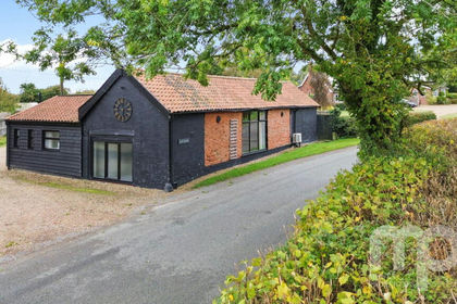 Added on 29/01/2026Barn Conversion
- Price
- Offers in Region of£600,000
- Size
- 1.97 acres
The Street, Wramplingham, Wramplingham, Norfolk NR18 England
Added on 06/09/2026House with Land