The Coed, Cwmyoy, Abergavenny, Monmouthshire, NP7
- Land size
- 30.97 acres
- Bedrooms
- 3
- Bathrooms
- 1
Key Features
- Superb location within the picturesque Llanthony Valley
- Grade II Listed three-bedroom farmhouse in need of full modernisation with attached traditional stone barn which could be incorporated into the dwelling (STP)
- Detached Grade II Listed building with development potential and range of modern agricultural buildings and yard
- Two ringfenced compartments of productive pasture, paddocks and woodland set over two distinct Lots
- Appealing to lifestyle, development, equestrian, agricultural and rural enterprise purchasers
- Available as a Whole and in Two Lots
- Lot 1 – Farmhouse, buildings and pastureland – 14.67 acres
- Lot 2 – Pastureland and woodland with river frontage – 16.30 acres
- Extending as a whole to approximately 30.97 acres (12.53 hectares)
Description
The Coed is positioned on either side of the Llanthony Road within the beautiful Llanthony Valley within the popular parish of Cwmyoy.
• Superb location within the picturesque Llanthony Valley •
• Excellent connectivity to the A465 at Llanvihangel Crucorney •
• Grade II Listed three-bedroom farmhouse in need of full modernisation •
• Attached traditional stone barn which could be incorporated into the dwelling (STP) •
• Detached Grade II Listed building with development potential and range of modern agricultural buildings and yard •
• Two ringfenced compartments of productive pasture, paddocks and woodland set over two distinct Lots •
• Appealing to lifestyle, development, equestrian, agricultural and rural enterprise purchasers •
• Available as a Whole and in Two Lots •
• Lot 1 – Farmhouse, buildings and pastureland – 14.67 acres •
• Lot 2 – Pastureland and woodland with river frontage – 16.30 acres •
• Extending as a whole to approximately 30.97 acres (12.53 hectares) •
DISTANCES FROM THE COED
Cwmyoy 1.2 miles • Llanvihangel Crucorney 2.5 miles
Llanthony 4 miles • Abergavenny 6.2 miles • Usk 17.7 miles
Hereford 21.2 miles • Monmouth 23.1 miles • Ross-on-Wye 24.7 miles
Cardiff 36.8 miles • Bristol 53.3 miles • London 160 miles
Abergavenny Railway Station 7.8 miles
Hereford Railway Station 21.7 miles • Newport Railway Station 34.9 miles
Cardiff Airport 50.5 miles • Bristol Airport 56.8 miles
London Heathrow Airport 146 miles
(all distances are approximate)
LOCATION & SITUATION
The Coed enjoys an excellent location and situation in a slightly elevated position within the beautiful Llanthony Valley with views of the valley and the hamlet of Cwmyoy. The property is positioned on either side of the Llanthony Road within the parish of Cwmyoy, just 2.5 miles west of the A465 at Llanvihangel Crucorney. The property enjoys an excellent rural position with countryside views.
Cwmyoy is a small hamlet in Monmouthshire, known for its distinctive, crooked St Martin’s Church. The village is located in the Vale of Ewyas, within the Black Mountains, and the name “Cwmyoy” translates to “valley of the yoke” in Welsh, referring to the shape of the surrounding hills.
The property enjoys a desirable position close to the delightful village of Llanvihangel Crucorney. Within the village you will find a primary school, village shop, garage, village hall and ‘The Skirrid Inn’ which is Wales’ oldest pub.
Abergavenny is just 6.2 miles to the south. Known as the Gateway to Wales, Abergavenny is blessed with scenic views, excellent road and rail links and a wide range of services and amenities. As a popular gateway town, Abergavenny offers easy access to both the Brecon Beacons and Black Mountains. With that, you get endless opportunities for incredible walks amongst peaks such as Sugar Loaf, Skirrid and Blorenge.
The town is also home to the Abergavenny Food Market, providing local produce and artisanal goods on the 4th Thursday of every month. Abergavenny plays host to several events throughout the year, including the world-famous Abergavenny Food Festival, alongside other attractions such as the Vintage Steam Rally. Additionally, the town boasts popular establishments including the Angel Hotel and the Art Shop & Chapel, as well as a convenient leisure centre, theatre and cinema. Education within the town includes a number of well respected primary schools and the recently redeveloped King Henry VIII 3-19 school, which provides a state-of-the-art education establishment.
An abundance of tourism and recreational activities exist within Monmouth and the wider region, especially within the beautiful Wye Valley which is only a short drive away. The Brecon Beacons National Park is located to the North of Abergavenny. Tintern Abbey, Raglan Castle, the Monmouthshire and Brecon Canal and Chepstow Castle are all easily accessible.
THE FARMHOUSE
Accessed from the south side of the Llanthony Road, the gated farm drive winds up to the property with meadows either side, leading up to a parking area for several vehicles to the front of the farmhouse.
Dating from the 16th Century the Farmhouse and attached two storey barn is a Grade II Listed C16 longhouse featuring stone painted elevations under a pitched tiled roof.
The front door opens into the entrance porch with boarded floor. From the porch is the sitting room/dining room with window to the front featuring solid floor and impressive open fireplace with woodburning stove, oak beam lintel and bread oven. From the front side of the sitting room is the kitchen with front aspect window and linoleum floor featuring base and wall units with composite worktops, a solid fuel three door oven Rayburn which also heats the hot water and radiators and metal sink.
Accessed off the rear side of the sitting room is the shower room with walk in shower, wc, wash basin and single aspect window to the rear.
At the rear of the sitting room is a rear hall with external door and stairs up to the first floor. First on the left-hand side is a double bedroom with single aspect window to the front with views, carpeted floor, boarded up fireplace and storage cupboard. Bedroom two is a double with single aspect window to the rear. Bedroom three is a double with single aspect window to the front with view and carpeted floor.
Extending off the northern side of the farmhouse is the attached two storey traditional stone barn which shares the ridge height of the dwelling. This could certainly be incorporated into the dwelling to provide additional accommodation subject to gaining the necessary planning consents.
The farmhouse is in need of full renovation but with impressive features will make a fantastic property for anyone with development and lifestyle interests.
TRADITIONAL BARN & OUTBUILDINGS
Positioned directly to the rear of the farmhouse is the Grade II listed two storey traditional stone outhouse/detached kitchen with accommodation over known as the ‘back kitchen’ which dates from the 17th Century and would have been a kitchen with accommodation above. The building features traditional stone elevations under a pitched corrugated roof. The building has potential to be converted to alternative uses, subject to planning, which will appeal to the market as ancillary accommodation or holiday let/work at home studio etc. To the western end of the ‘back kitchen’ is a 19th century cart shed with two enclosed areas and a stable which could also potentially be incorporated into the building.
Next is a four bay steel portal framed general purpose agricultural building with block and tin sheeted elevations, roof and earth floor. The building provides a useful outbuilding which could be used for agricultural or equestrian purposes but could also provide useful covered storage for anyone undertaking a renovation.
Last is a modern three bay steel portal framed building with block and tin sheeted elevations with gated open front elevation and galvanised rear door appealing to anyone with agricultural or equestrian interests.
All the outbuildings are in reasonable condition with the stone barn providing scope for change of use and conversion to residential subject to planning.
LAND & WOODLAND
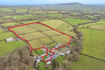
The land at The Coed is set over two distinct compartments. The primary compartment comprises seven field enclosures and is a mix of moderately to very gently sloping permanent pasture, all capable of being grazed and mown for fodder. As the compartment is rectangular, with several rectangular field enclosures, these could be subdivided further into paddocks. The property benefits from Rights of Common for grazing of 105 sheep. The primary compartment, including the house and buildings (Lot 1) extends to approximately 14.67 acres (5.94 ha).
The second compartment is positioned opposite and is accessed from several access points from the northern side of the Llanthony Road. The pastureland element forms a compact rectangular shaped parcel with the northern bank of the River Honddu forming the northern boundary. The deciduous woodland gently slopes to the river Honddu, which bounds its entire northern length and contains several pockets of level pastureland. The spectacular countryside and natural beauty of the land would certainly appeal to lifestyle buyers seeking amenity land for potential recreational and leisure use such as managing for conservation. There is also potential for more commercial enterprises such as glamping to be operated during the summer, subject to obtaining the necessary planning consents from the BBNP Authority. The second compartment (Lot 2) extends to approximately 16.30 acres (6.60 ha).
All the land at The Coed provides two extensive ring-fenced compartments with agricultural, equestrian, amenity and conservation appeal and would provide the perfect grazing for a collection of ponies or pedigree livestock.
In total the land and property at The Coed as a whole extends to approximately 30.97 acres (12.53 hectares).
KEY INFORMATION
Services: Spring fed private water supply and mains electricity connected. Heating is by way of a solid fuel Rayburn which also heats the water and radiators. Foul drainage is to a septic tank. Any interested parties are to make, and reply upon their own enquiries, regarding any utility or service connections to the site.
Wayleaves & Easements: The property is sold subject to all existing Wayleaves & Easements that may exist at the date of sale. Any interested parties are to make, and reply upon their own enquiries, regarding Wayleaves & Easements. Two Restricted Byways and Public Rights of Way cross the property.
Sale Method: The Coed is available For Sale by Private Treaty. The Vendor & Selling Agents reserve the right to conclude the sale by any alternative Sale Method.
Council Tax Band: E.
Local Planning Authority: Bannau Brycheiniog National Park Authority.
Telephone: .
Viewings: Strictly by appointment with the selling agents.
Directions: From Abergavenny proceed north on the main A465 Abergavenny to Hereford Road, for approximately 5 miles. Take the first exit left into the village of Llanvihangel Crucorney, past the Skirrid Mountain Inn, turn immediately left and continue on this road for 2.5 miles. The property will then be on your left hand side with Lot 2 opposite.
WHAT 3 WORDS
swimsuits.stung.estimate
Map Location
Property details
- Tenure
- Ask Agent
- Council Tax Band
- Ask Agent
- Date Posted
- 2026-09-11
Market Value Analysis
Compared with 129 Farms & Smallholdings listings in Wales (25+ acres).
Utilities & Restrictions
Utilities
- Electricity
- Ask Agent
- Water
- Ask Agent
- Heating
- Ask Agent
- Broadband
- Ask Agent
- Sewerage
- Ask Agent
Rights & Restrictions
- Public Rights of Way
- Ask Agent
- Private Rights of Way
- Ask Agent
- Listed Property
- Ask Agent
- Restrictions
- Ask Agent
Listed status, conservation areas and planning constraints for this location are in the full report.
Property Features
- Accessibility
- Ask Agent
- Parking
- Parking Available
- Garden
- Garden
Beyond the particulars: planning activity, flood history, heritage and ground risks, checked for this exact spot.
Connectivity
Broadband
Fastest speed available at this postcode
8 Mbps
Under 10 Mbps here
Suitable for
- Basic browsing & email
Mobile signal
Outdoor predictions; indoor signal depends on building materials.
Ofcom Connected Nations postcode-level predictions. Speeds and signal are modelled, not measured, and vary between addresses and providers.
Signal is the easy part. Planning activity, flood history and protected designations here are in the full report.
Nearest Schools
Primary
- Llanvihangel Crucorney County Primary School2.3 miles
- Pupils
- 67
- Type
- Infants & Juniors
- Language
- English medium school / provision
- Llantilio Pertholey CV Primary4 miles
- Pupils
- 203
- Type
- Infants & Juniors
- Language
- English medium school / provision
- Ysgol Gymraeg Y Fenni4.4 miles
- Pupils
- 271
- Type
- Nursery, Infants & Juniors
- Language
- Welsh medium school / provision (including transitional)
- King Henry VIII 3194.6 miles
- Pupils
- 1,310
- Type
- Middle (ages 3-19)
- Language
- English medium school / provision
- Cantref Primary4.8 miles
- Pupils
- 235
- Type
- Infants & Juniors
- Language
- English medium school / provision
Secondary
- King Henry VIII 3194.6 miles
- Pupils
- 1,310
- Type
- Middle (ages 3-19)
- Language
- English medium school / provision
- Crickhowell High School5.7 miles
- Pupils
- 942
- Type
- Secondary (ages 11-19)
- Language
- English medium school / provision
- Brynmawr Foundation School8.9 miles
- Pupils
- 569
- Type
- Secondary (ages 11-16)
- Language
- English medium school / provision
- Ebbw Fawr Learning Community11 miles
- Pupils
- 1,406
- Type
- Middle (ages 3-16)
- Language
- English medium school / provision
- Abersychan Comprehensive12 miles
- Pupils
- 739
- Type
- Secondary (ages 11-16)
- Language
- English medium school / provision
Distances are straight-line from the advertised location. Source: the national school registers (DfE, Welsh Government, Scottish Government) and Ofsted.
Schools are just the start: sold prices nearby, planning activity and any flood history are in the full report.
Amenities
Supermarket
GP surgery
Pharmacy
Walking trail
Straight-line distances from the advertised location. Sources: NHS records, Geolytix supermarket locations, OS Open Greenspace and the national trails registers.
The area stacks up? Now check the location itself: planning nearby, protected designations and past flooding.
Getting Around
Nearest station
Nearest bus stop
Typical drive times
Straight-line distances from the advertised location; drive times are typical free-flow times over OpenStreetMap road data, so allow more at peak. Public transport locations from DfT NaPTAN.
Easy to reach matters. So do planning activity, flood history and ground risks: all in the full report.
Flood Risk
From Natural Resources Wales flood map open data, checked around the advertised map pin and allowing for the listed acreage where known. This summary comes from LandSale, the advertising platform, not from the listing agent, and is not part of the agent's particulars. Risk can vary across a single holding, so verify anything critical through your own searches before committing.
Rivers and the sea
Surface water
The detail behind these bandings
The full report pinpoints where this location sits on the flood maps, and runs the deeper checks that usually only surface after an offer.
- Exact flood zones & annual chances (included in the full report)
- Any recorded past flooding (included in the full report)
- Planning activity nearby (included in the full report)
- Heritage & conservation (included in the full report)
- Protected nature designations (included in the full report)
- Ground risks (included in the full report)
- Sold prices nearby (included in the full report)
£14.99 · one-off purchase
By LandSale, the platform. Not provided by the listing agent. Ready in about a minute.
Important notice: Information, maps and tags on this page are drawn from the advertising agent's marketing materials or generated automatically. LandSale has not verified them. Relying on these details is at your own risk, always carry out independent checks before committing to a purchase.
LandSale full disclaimer
Marketing information only - not formal particulars. The details on this website are provided for general guidance and do not constitute an offer or contract. Neither LandSale nor the advertising estate/land agent accepts responsibility for any inaccuracy.
1. Source of information
- Listing content: Core description, asking price, tenure, measurements, photographs and planning history originate from the marketing materials of the advertising estate or land agent. LandSale does not author this content and cannot guarantee its accuracy.
- Automated tags & categorisation: Property type, land-use class, acreage bands and similar labels may be applied by machine-learning models. They are intended as a helpful guide only and may not reflect the property's legal status or permitted use.
- Third-party & enriched data layers: Maps, boundary outlines, planning designations, soil reports, broadband coverage and other environmental or location-based insights are licensed from external suppliers. Such data are supplied “as is", may be incomplete or out of date and are subject to change without notice.
2. Verification required
Prospective purchasers must verify critical matters, including but not limited to planning permission, title boundaries, public rights of way, environmental constraints, acreage, services, access and VAT status, through their own inspections, specialist surveys, legal advisers and the selling agent before relying on the information or entering into any contract.
3. No warranty or liability
LandSale gives no warranty, express or implied, as to the accuracy, completeness or fitness for any particular purpose of the information displayed. LandSale shall not be liable for any loss, damage, cost or expense arising directly or indirectly from any use of or reliance on such information, save where liability may not be excluded by law.
4. Updates & feedback
If you believe any detail on this listing is inaccurate, please let us know. We will investigate and, where appropriate, update the listing or notify the agent.
© LandSale | Version 1.3 - August 2026
Listing agent
Powells, Monmouth
Singleton Court Business Park, Wonastow Road, Monmouth, NP25 5JA
Contact Powells, Monmouth
Singleton Court Business Park, Wonastow Road, Monmouth, NP25 5JA
View agent profileSimilar properties for sale
- Price
- Guide Price£710,000
- Size
- 19.13 acres
Little Park Farm, Llanvihangel Crucorney, Abergavenny, NP7, Grosmont, Monmouthshire NP7 Wales
Added on 21/03/2026Barn Conversion
- Price
- Guide Price£925,000
- Size
- 24.53 acres
Added on 29/01/2026Farm
- Price
- Guide Price£1,000,000
- Size
- 28 acres
Llanddewi Fach, Erwood, Builth Wells, Glasbury, Powys LD2 Wales
Added on 14/05/2026Smallholding
- Price
- £1,000,000
- Size
- 29 acres
Llantrisant, Usk, NP15, Llantrisant Fawr, Monmouthshire NP15 Wales
Added on 29/01/2026Small Farm
- Price
- Guide Price£900,000
- Size
- 50 acres
Added on 24/04/2026Farm
- Price
- Guide Price£1,000,000
- Size
- 19.5 acres
Stirbridge Farm, Risbury, Leominster, Herefordshire, Humber, Herefordshire, County of HR6 England
Added on 15/05/2026Smallholding
- Price
- £960,000
- Size
- 24 acres
Added on 15/04/2026Farm
- Price
- £899,950
- Size
- 28.8 acres
Added on 20/05/2026Smallholding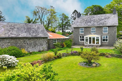
- Price
- £750,000
- Size
- 20 acres
Llanddeusant, Llangadog, Carmarthenshire., Llanddeusant, Carmarthenshire SA19 Wales
Added on 04/06/2026Livestock Farm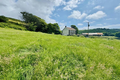
- Price
- Offers Over£699,950
- Size
- 36 acres
Eaglesbush, Cimla, Briton Ferry, Neath Port Talbot SA11 Wales
Added on 26/06/2026Small Farm