Land And Buildings At INEOS Aycliffe Business Park, Newton Aycliffe, Durham, DL5
- Land size
- 3.1 acres
Key Features
- Freehold manufacturing facility
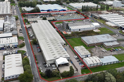
- 135,000 sq ft on circa 11 acres.
- Located within INEOS Aycliffe Business Park
- Guide Price £4m
Description
The Property is located to the rear of INEOS Aycliffe Business Park, formerly owned by Hydro Polymers, which sold the site to INEOS Newton Aycliffe Limited in 2008. The other site occupiers are Inovyn Newton Aycliffe Limited (formerly known as Norsk Hydro Polymers Limited) and INEOS Enterprises Compounds Ltd, which jointly occupy roughly four-fifths of the site. The estate is contained within a high-security ring fence, with gated secure access from School Aycliffe Lane.
Access to the Property is via the manned, high-security entrance, leading onto a well-maintained Business Park with estate roads and an open layout, with plenty of green space between buildings, reflecting its origins as an MoD munitions factory and depot. All in all, it presents well and comprises a modern production facility incorporating production areas, laboratories, offices, stores, tank farms and all of the supporting infrastructure, such substations, pump rooms and interceptors.
The subject Property comprises a modernised manufacturing facility, three storage buildings, a covered loading bay, a tank farm, hardstanding areas and internal roads, occupying a total site area of approximately 11 acres.
Building H
Building H, the main manufacturing facility, is a purpose-built industrial building comprising three steel portal-framed
interconnection buildings providing a gross internal area of approximately 80,000 sq ft, with an eaves height of circa 10 metres. This building was substantially refurbished and modernised in 2002. Internally, the building is subdivided with non-structural partition walling to create a range of offices, a boardroom, laboratories, server room, staff canteen, changing rooms, stores and a tank room for handling wet and dry bulk goods, which can be filled directly from the external bulk tanks. The building has LED lighting throughout, and a high-capacity medical-grade HVAC system was installed above the ceiling grid in the production hall.
External Tank Farm
Serving Building H is an external tank farm which houses bunded bulk tanks for receiving wet and dry goods, including high-viscosity fluids. The tanks can be filled directly from the delivery tankers and are connected to the internal tanks to enable direct transfer of products to the production facility.
An electricity substation is located adjacent to the external tank farm, supplied from the estate ring main and sub-metered.
Covered Loading Bay Building H is linked to Building F by a canopy to create a covered loading area. The canopy is of steel portal-frame construction with a profile metal-clad roof, built in 2001. The canopy has an eaves height of circa 8 metres and provides a useful open-sided store and loading area.
Building F
Building F is an overclad 1940s red-brick MoD building under a pitched, metal-truss-framed roof. The building was refurbished in 2020, externally overclad with metal profile sheeting and fitted with two rapid roller doors. Internally, the building has exposed brick walls, painted non-slip floors and fluorescent strip lighting. The building intercommunicates with Building H via an internal airlock.
Building D
Building D comprises three interconnecting ex-MoD buildings of brick construction, with approximately 4 meters to eaves. The roof is pitched with a central valley and perimeter gutters. The building was refurbished in the 1980s and overclad with steel profile cladding. The building was further improved in 2020, when four rapid roller doors and internal partitioning were installed, and the building was extended to create an air-conditioned office.
Building G
Building G comprises an ex-MoD 1940s brick building with metal trusswork and a wooden lath ceiling. Reclad in the 1980s with metal sheeting, it provides dry storage but has no electricity or water supply.
Map Location
Property details
- Tenure
- Freehold
- Council Tax Band
- Ask Agent
- Date Posted
- 2026-09-10
Utilities & Restrictions
Utilities
- Electricity
- Ask Agent
- Water
- Ask Agent
- Heating
- Ask Agent
- Broadband
- Ask Agent
- Sewerage
- Ask Agent
Rights & Restrictions
- Public Rights of Way
- Ask Agent
- Private Rights of Way
- Ask Agent
- Listed Property
- Ask Agent
- Restrictions
- Ask Agent
Listed status, conservation areas and planning constraints for this location are in the full report.
Property Features
- Accessibility
- Ask Agent
- Parking
- Ask Agent
- Garden
- Ask Agent
Beyond the particulars: planning activity, flood history, heritage and ground risks, checked for this exact spot.
Connectivity
Broadband
Fastest speed available at this postcode
26 Mbps
Standard (10-30 Mbps)
Suitable for
- Web & social
- Music streaming
- Standard video calls
Mobile signal
Outdoor predictions; indoor signal depends on building materials.
Ofcom Connected Nations postcode-level predictions. Speeds and signal are modelled, not measured, and vary between addresses and providers.
Signal is the easy part. Planning activity, flood history and protected designations here are in the full report.
Nearest Schools
Primary
- Aycliffe Village Primary and Nursery School1.1 milesNo Ofsted rating
- Ages
- 3 to 11
- Pupils
- 179
- Type
- Academy converter
- Stephenson Way Academy and Nursery School1.2 milesOfsted: Good
- Ages
- 3 to 11
- Pupils
- 285
- Type
- Academy sponsor led
- Sugar Hill Primary School1.3 milesOfsted: Good *
- Ages
- 3 to 11
- Pupils
- 448
- Type
- Community school
- St Joseph's Catholic Primary School1.3 milesOfsted: Good
- Ages
- 2 to 11
- Pupils
- 150
- Type
- Academy sponsor led
- Faith
- Roman Catholic
- Woodham Burn Community Primary School and Nursery1.3 milesOfsted: Requires improvement
- Ages
- 3 to 11
- Pupils
- 222
- Type
- Academy converter
Secondary
- UTC South Durham928 metresOfsted: Good
- Ages
- 14 to 19
- Pupils
- 421
- Type
- University technical college
- Greenfield Academy1.3 milesOfsted: Requires improvement
- Ages
- 11 to 16
- Pupils
- 566
- Type
- Academy converter
- Woodham Academy1.9 milesNo Ofsted rating
- Ages
- 11 to 16
- Pupils
- 1,071
- Type
- Academy converter
- Longfield Academy4 milesOfsted: Good *
- Ages
- 11 to 16
- Pupils
- 660
- Type
- Academy sponsor led
- Wyvern Academy4.5 milesOfsted: Good
- Ages
- 11 to 16
- Pupils
- 464
- Type
- Academy sponsor led
* Latest graded judgement covers quality of education only; no overall grade was issued under the 2024-25 inspection framework.
Distances are straight-line from the advertised location. Source: the national school registers (DfE, Welsh Government, Scottish Government) and Ofsted.
Schools are just the start: sold prices nearby, planning activity and any flood history are in the full report.
Amenities
Supermarket
GP surgery
Pharmacy
Hospital
Straight-line distances from the advertised location. Sources: NHS records, Geolytix supermarket locations, OS Open Greenspace and the national trails registers.
The area stacks up? Now check the location itself: planning nearby, protected designations and past flooding.
Getting Around
Nearest station
Nearest bus stop
Typical drive times
Straight-line distances from the advertised location; drive times are typical free-flow times over OpenStreetMap road data, so allow more at peak. Public transport locations from DfT NaPTAN.
Easy to reach matters. So do planning activity, flood history and ground risks: all in the full report.
Flood Risk
From Environment Agency flood map open data, checked around the advertised map pin and allowing for the listed acreage where known. This summary comes from LandSale, the advertising platform, not from the listing agent, and is not part of the agent's particulars. Risk can vary across a single holding, so verify anything critical through your own searches before committing.
Rivers and the sea
Surface water
The detail behind these bandings
The full report pinpoints where this location sits on the flood maps, and runs the deeper checks that usually only surface after an offer.
- Exact flood zones & annual chances (included in the full report)
- Any recorded past flooding (included in the full report)
- Planning activity nearby (included in the full report)
- Heritage & conservation (included in the full report)
- Protected nature designations (included in the full report)
- Ground risks (included in the full report)
- Sold prices nearby (included in the full report)
£14.99 · one-off purchase
By LandSale, the platform. Not provided by the listing agent. Ready in about a minute.
Important notice: Information, maps and tags on this page are drawn from the advertising agent's marketing materials or generated automatically. LandSale has not verified them. Relying on these details is at your own risk, always carry out independent checks before committing to a purchase.
LandSale full disclaimer
Marketing information only - not formal particulars. The details on this website are provided for general guidance and do not constitute an offer or contract. Neither LandSale nor the advertising estate/land agent accepts responsibility for any inaccuracy.
1. Source of information
- Listing content: Core description, asking price, tenure, measurements, photographs and planning history originate from the marketing materials of the advertising estate or land agent. LandSale does not author this content and cannot guarantee its accuracy.
- Automated tags & categorisation: Property type, land-use class, acreage bands and similar labels may be applied by machine-learning models. They are intended as a helpful guide only and may not reflect the property's legal status or permitted use.
- Third-party & enriched data layers: Maps, boundary outlines, planning designations, soil reports, broadband coverage and other environmental or location-based insights are licensed from external suppliers. Such data are supplied “as is", may be incomplete or out of date and are subject to change without notice.
2. Verification required
Prospective purchasers must verify critical matters, including but not limited to planning permission, title boundaries, public rights of way, environmental constraints, acreage, services, access and VAT status, through their own inspections, specialist surveys, legal advisers and the selling agent before relying on the information or entering into any contract.
3. No warranty or liability
LandSale gives no warranty, express or implied, as to the accuracy, completeness or fitness for any particular purpose of the information displayed. LandSale shall not be liable for any loss, damage, cost or expense arising directly or indirectly from any use of or reliance on such information, save where liability may not be excluded by law.
4. Updates & feedback
If you believe any detail on this listing is inaccurate, please let us know. We will investigate and, where appropriate, update the listing or notify the agent.
© LandSale | Version 1.3 - August 2026

Listing agent
Bruton Knowles, Gloucester
Olympus House, Olympus Park, Gloucester, GL2 4NF
Contact Bruton Knowles, Gloucester
Olympus House, Olympus Park, Gloucester, GL2 4NF
View agent profileSimilar properties for sale
- Price
- Guide Price£4,200,000
- Size
- 2.95 acres
Added on 14/09/2026Warehouse
- Price
- £2,650,000
- Size
- 0.66 acres
Mercantile Road, Houghton le Spring, Tyne and Wear, DH4, Hetton, Sunderland DH4 England
Added on 29/01/2026Industrial Land
- Price
- £4,250,000
- Size
- 2.24 acres
Added on 29/01/2026Warehouse
- Price
- Guide Price£3,800,000
- Size
- 0.45 acres
Added on 29/01/2026Industrial LandLeasehold
- Price
- Guide Price£2,750,000
- Size
- 0.77 acres
Added on 17/07/2026Industrial Land
- Price
- £3,650,000
- Size
- 1.04 acres
Unit 2 Airedale Park, Royd Ings Avenue, Keighley, Keighley, Bradford BD21 England
Added on 17/07/2026Warehouse
- Price
- Offers in Region of£2,500,000
- Size
- 0.23 acres
Units 1, 2, 3 & 4, Spence Lane, Leeds, LS12, Leeds South, Leeds LS12 England
Added on 17/07/2026Warehouse
- Price
- Offers in Region of£4,500,000
- Size
- 1.67 acres
Futures Way, Off Bolling Road, Bradford, West Yorkshire, BD4, Bradford East, Bradford BD4 England
Added on 29/01/2026Warehouse