Junction 39 Business Park, Green Farm, Shap, Penrith, Cumbria CA10
- Land size
- 1.62 acres
Key Features
- A part-let freehold investment comprising two modern warehouse buildings and a veterinary practice unit
- Located adjacent to the A6, 2 miles from Junction 39 (M6), providing excellent road communications
- Total Gross Internal Area of approximately 3,119.36m2 (33,576 sq ft) on a site extending to circa 1.62 acres
- Unit 1 – Vacant warehouse extending to approximately 21,629 sq ft, benefitting from electric up-and-over loading doors, dock levelling facility, generous dedicated car parking, and a minimum eaves h
- Unit 2 – Warehouse let to William Glynn Burrow t/a GB Burrow & Son at a current passing rent of £68,067 per annum on FRI terms
- Unit 3 – Veterinary practice premises let to Tarn Farm Vets Limited on FRI terms, at a current passing rent of £8,840 per annum
- Current rental income of £76,907 per annum, with strong reversionary potential to approximately £208,907 per annum upon letting Unit 1
- An excellent and rare opportunity to acquire a high-quality freehold industrial asset along the M6 corridor, suitable for owner-occupiers (with income from Units 2 and 3) or investors seeking asset
- Guide Price: £2,750,000, reflecting a gross reversionary yield of 7.60% assuming full letting of the estate and a low capital value rate of £81.90 per sq ft
Description
LOCATION
Junction 39 Business Park is situated within the village of Shap in the South East of Cumbria and North West of England. Shap is a linear village and civil parish arranged along the A6 road within the District of Eden and being less than 1 mile to the east of the Lake District National Park and 2 miles northwest of the Yorkshire Dales National Park. Shap has a population of 1,264 (2011 Census) offering local services including a primary school, small convenience store, café, two public houses, a fish and chip shop, butchers and a number of bed and breakfasts. The village is very much rural and lies over 1,000 ft above sea level.
The nearest towns are Penrith which is approximately 14 miles to the north and Kendal, 15 miles to the south, both reached via the A6 or M6. Penrith has a population of 15,200 (2012 Census) and is known as an attractive affluent market town benefiting from good access to the Lake District National Park as well as being situated on Junction 40 of the M6/A66 interchange. Penrith offers good retail and leisure facilities including Sainsburys, Booths, Morrisons and Aldi Supermarkets as well as a range of national retailers. The town has a train station on the West Coast Main Line with direct services north to Carlisle and Glasgow and south to the London Euston with a journey time of around 3 hours.
Kendal is the principal town of South Lakeland with a resident population of 29,495 (2011 Census) and is also a popular tourist destination being on the southern boundaries of the Lake District National Park and 10 miles away from Windermere. Other nearby towns include Windermere, 21 miles to the south west and Kirkby Stephen, 19 miles to the east. The village of Tebay is around 8 miles to the south east adjacent to Junction 38 and Westmorland Services.
The site is accessed directly from the A6 which travels south where it meets up with Junction 39 of the M6, around 2 miles away. The A6 continues south leading to Kendal or north to Penrith.
DESCRIPTION
The site comprises a former factory which was redeveloped in 2019, during which most of Unit 1 was demolished and re-built and Unit 2 was fully re-clad. Unit 1 is situated centrally within the site extending north and northeast and is attached to Unit 2 at the southwest corner, and Unit 3, the veterinary practice, is situated beyond with a separate vehicle entrance and car park at the southwest corner.
Unit 1 Junction 39 Business Park
A modern warehouse building, substantially re-built in 2019, of steel portal frame construction with profile clad elevations underneath an insulated multi-pitched profile clad roof. The building incorporates two electric up-and-over vehicle doors (4.29m wide x 5.00m high and 3.99m wide x 3.58m high) as well as a dock levelling electric vehicle door (3.00m wide x 3.47m high) with a 0.91m fall and 4.00m wide loading lane.
Internally, the accommodation provides open plan warehousing with solid concrete flooring, exposed profile clad walls, translucent roof lights, suspended LED warehouse lighting, gas hot air blowers and with a minimum eaves height of 4.94m rising to 9.67m at the top of the apex frame. There is an amenity block with an office, male WCs and a separate female/disabled WC.
Externally, there are loading areas to the front/side, formed in concrete hardstanding as well as having a strip of tarmacadam car parking with marked spaces for around 18 vehicles and further spaces available within the front and rear yard.
Unit 2 Junction 39 Business Park
The redeveloped warehouse has been subject to extensive works, being of steel portal frame construction with part double/triple skinned profile clad elevations and underneath an insulated profile clad roof incorporating translucent roof lights. The premises are accessed via two separate electric up and over vehicle doors (width 4.12m x height 4.15m and width 4.01m x height 4.48m) as well as a pedestrian entrance from the adjoining offices.
Internally, the accommodation has solid concrete flooring which has been levelled, polished and treated with an anti-dust covering, suspended downlighting, mounted and suspended gas hot air blowers and with a minimum eaves height of 7.47m rising to 9.94m at the top of the apex frame.
The tenant of Unit 2 also occupies the first-floor attached offices which is a two-storey building of steel frame construction with part brick/profile clad elevations underneath a pitched profile clad roof and incorporating aluminium framed double-glazed windows and doors.
At first floor, the offices have been refurbished into cellular rooms with carpeted flooring, plaster painted walls, suspended ceiling, WC and door to the adjacent warehouse.
Externally, there is a front loading area, formed in concrete hardstanding and with ample areas for car parking.
Unit 3 Junction 39 Business Park
At ground floor, the offices are used as a base for a veterinary practice and are fitted out with an entrance lobby, kitchenette and WCs off, a main open plan office, two cellular office/meeting rooms and stairs to the first floor. The offices have carpeted flooring, plaster painted walls and suspended ceiling incorporating recessed fluorescent lighting.
Externally, to the front of the offices is a tarmacadam car park.
ACCOMMODATION
The premises provide the following approximate gross internal areas:
Unit 1 Junction 39 Business Park
Ground Floor/Total - 2,009.41m² 21,629 sq ft
Unit 2 Junction 39 Business Park
Ground Floor - 02.55m² (9,715 sq ft)
First Floor - 103.70m2 (1,116 sq ft)
Total - 1,006.25m² (10,831 sq ft)
Unit 3 Junction 39 Business Park
Ground Floor/Total - 103.70m² (1,116 sq ft)
Overall Areas
Total Approximate GIA - 3,119.36m2 (33,576 sq ft)
Total Site Area - 0.66 Hectares (1.62 Acres)
SERVICES
It is understood that the land and property is connected to mains electricity with a dedicated sub-station and transformer located in the far eastern corner of the site. The sub-station has the capacity and supply of 11,000 volts which is transformed down to 340 volts.
Unit 1 Junction 39 Business Park – connected to mains electricity (three phase), gas, water and the mains drainage/sewerage system. Heating is via a gas-fired hot air blowers.
Unit 2 Junction 39 Business Park – connected to mains electricity, water and the mains drainage/sewerage system and heating is via gas hot air blowers supplied from a propane gas tank situated within the yard area.
Unit 3 Junction 39 Business Park – connected to mains electricity, water and the mains drainage/sewerage system and heating is via a wet central system and boiler powered by the above-mentioned propane gas cylinder.
Prospective occupiers should make their own enquiries as to the services available for future use.
RATEABLE VALUE
Unit 1 and Unit 2 are assessed with a Rateable Value of £106,000 with current estimated rates payable of £58,830 per annum. Prospective occupiers should check the exact rates payable with Westmorland & Furness Council – .
ENERGY PERFORMANCE CERTIFICATE
The unit is being re-assessed, further details available upon request.
LEASE DETAILS
Lease/tenant details available in the attached brochure.
ASSET MANAGEMENT OPPORTUNITIES
The property offers a number of asset management initiatives, including:
• Letting of Unit 1 to capture the significant reversionary potential, increasing the overall income from £73,000 per annum to approximately £200,000 per annum
• Retain Unit 1 for owner occupation and benefit from high quality distribution warehousing whilst generating income from the remaining space
• Potential to subdivide Unit 1 to create two smaller, self-contained units
• Scope to regear existing leases on Units 2 and 3, securing longer-term income
PROPOSAL
The site and properties are available freehold (Title Number: CU168958) subject to the existing leases at a guide price of £2,750,000.
MONEY LAUNDERING LEGISLATION
Edwin Thompson is bound to comply with Anti-Money Laundering legislation including obtaining evidence of the identity and proof of address of potential buyers. Prior to an offer being accepted, interested parties will need to provide the requested evidence.
EASEMENTS, WAYLEAVES AND RIGHTS OF WAY
The land and property are sold subject to and with the benefit of all public and private rights of way, lights, drainage, cables, pylons or other easements, restrictions or obligations whether or not the same are described in these particulars of sale.
VAT
It is advised that the property is elected for VAT and therefore VAT is payable on top of the sale consideration.
LEGAL COSTS
Each party to bear their own legal costs in the preparation and settlement of the sale documentation together with any VAT thereon.
VIEWING
The property is available to view by prior appointment with the Kendal office of Edwin Thompson LLP.
Contact:
Ellie Oakley
John Haley
Paul Evans
IMPORTANT NOTICE
Edwin Thompson for themselves and for the Vendor of this property, whose Agents they are, give notice that:
1. The particulars are set out as a general outline only for the guidance of intending purchasers and do not constitute, nor constitute part of, any offer or contract.
2. All descriptions, dimensions, plans, reference to condition and necessary conditions for use and occupation and other details are given in good faith and are believed to be correct, but any intending purchasers should not rely on them as statements or representations of fact, but must satisfy themselves by inspection or otherwise as to their correctness.
3. No person in the employment of Edwin Thompson has any authority to make or give any representation or warranty whatsoever in relation to this property or these particulars, nor to enter into any contract relating to the property on behalf of the Agents, nor into any contract on behalf of the Vendor.
4. No responsibility can be accepted for loss or expense incurred in viewing the property or in any other way in the event of the property being sold or withdrawn.
5. These particulars were prepared in April 2026.
Map Location
Property details
- Tenure
- Ask Agent
- Council Tax Band
- Ask Agent
- Date Posted
- 2026-07-17
Utilities & Restrictions
Utilities
- Electricity
- Ask Agent
- Water
- Ask Agent
- Heating
- Ask Agent
- Broadband
- Ask Agent
- Sewerage
- Ask Agent
Rights & Restrictions
- Public Rights of Way
- Ask Agent
- Private Rights of Way
- Ask Agent
- Listed Property
- Ask Agent
- Restrictions
- Ask Agent
Listed status, conservation areas and planning constraints for this location are in the full report.
Property Features
- Accessibility
- Ask Agent
- Parking
- Ask Agent
- Garden
- Ask Agent
Beyond the particulars: planning activity, flood history, heritage and ground risks, checked for this exact spot.
Connectivity
Broadband
Fastest speed available at this postcode
1.8 Gbps
Gigabit full fibre · available to 82% of premises
Suitable for
- 4K streaming on every screen
- Full-time home working
- Online gaming & big downloads
Mobile signal
Predicted 4G and 5G signal; indoor signal depends on building materials.
Ofcom Connected Nations postcode-level predictions. Speeds and signal are modelled, not measured, and vary between addresses and providers.
Signal is the easy part. Planning activity, flood history and protected designations here are in the full report.
Nearest Schools
Primary
- Shap Endowed CofE Primary School928 metresNo Ofsted rating
- Ages
- 3 to 11
- Pupils
- 88
- Type
- Voluntary aided school
- Faith
- Church of England
- Crosby Ravensworth CofE School3.5 milesOfsted: Good *
- Ages
- 3 to 11
- Pupils
- 42
- Type
- Voluntary aided school
- Faith
- Church of England
- Orton CofE School5.3 milesNo Ofsted rating
- Ages
- 3 to 11
- Pupils
- 47
- Type
- Voluntary aided school
- Faith
- Church of England
- Morland Area CofE Primary School5.3 milesOfsted: Good *
- Ages
- 2 to 11
- Pupils
- 119
- Type
- Voluntary aided school
- Faith
- Church of England
- Lowther Endowed School5.9 milesNo Ofsted rating
- Ages
- 5 to 11
- Pupils
- 34
- Type
- Voluntary aided school
Secondary
- Appleby Grammar School8.3 milesOfsted report card · May 2026
- Ages
- 11 to 18
- Pupils
- 357
- Type
- Academy converter
- Ullswater Community College10 milesOfsted: Good
- Ages
- 11 to 18
- Pupils
- 1,520
- Type
- Foundation school
- Queen Elizabeth Grammar School Penrith10 milesOfsted: Good
- Ages
- 11 to 18
- Pupils
- 1,026
- Type
- Academy converter
- The Queen Katherine School13 milesOfsted report card · May 2026
- Ages
- 11 to 19
- Pupils
- 910
- Type
- Academy converter
- Kirkby Stephen Grammar School13 milesOfsted: Good
- Ages
- 11 to 18
- Pupils
- 377
- Type
- Academy converter
* Latest graded judgement covers quality of education only; no overall grade was issued under the 2024-25 inspection framework.
Distances are straight-line from the advertised location. Source: the national school registers (DfE, Welsh Government, Scottish Government) and Ofsted.
Schools are just the start: sold prices nearby, planning activity and any flood history are in the full report.
Amenities
Supermarket
GP surgery
Pharmacy
Hospital
Green space
Walking trail
Straight-line distances from the advertised location. Sources: NHS records, Geolytix supermarket locations, OS Open Greenspace and the national trails registers.
The area stacks up? Now check the location itself: planning nearby, protected designations and past flooding.
Getting Around
Nearest station
Nearest bus stop
Typical drive times
Straight-line distances from the advertised location; drive times are typical free-flow times over OpenStreetMap road data, so allow more at peak. Public transport locations from DfT NaPTAN.
Easy to reach matters. So do planning activity, flood history and ground risks: all in the full report.
Flood Risk
Environment Agency open data, checked around the advertised map pin for the listed acreage. Long-term risk counts flood defences; the planning map's flood zones do not. The map pin for this listing marks the postcode area rather than the exact location, so these readings describe the surrounding area. Provided by LandSale, not the listing agent, and not part of the agent's particulars. Risk varies across a holding, so verify before committing.
Rivers and the sea
Planning map: Flood Zone 1.
Surface water
Not at the pin: mapped about 30 metres away.
These bandings are the summary. Where this location sits on the flood maps, plus planning activity, heritage and ground risks, is in the full report.
Important notice: Information, maps and tags on this page are drawn from the advertising agent's marketing materials or generated automatically. LandSale has not verified them. Relying on these details is at your own risk, always carry out independent checks before committing to a purchase.
LandSale full disclaimer
Marketing information only - not formal particulars. The details on this website are provided for general guidance and do not constitute an offer or contract. Neither LandSale nor the advertising estate/land agent accepts responsibility for any inaccuracy.
1. Source of information
- Listing content: Core description, asking price, tenure, measurements, photographs and planning history originate from the marketing materials of the advertising estate or land agent. LandSale does not author this content and cannot guarantee its accuracy.
- Automated tags & categorisation: Property type, land-use class, acreage bands and similar labels may be applied by machine-learning models. They are intended as a helpful guide only and may not reflect the property's legal status or permitted use.
- Third-party & enriched data layers: Maps, boundary outlines, planning designations, soil reports, broadband coverage and other environmental or location-based insights are licensed from external suppliers. Such data are supplied “as is", may be incomplete or out of date and are subject to change without notice.
2. Verification required
Prospective purchasers must verify critical matters, including but not limited to planning permission, title boundaries, public rights of way, environmental constraints, acreage, services, access and VAT status, through their own inspections, specialist surveys, legal advisers and the selling agent before relying on the information or entering into any contract.
3. No warranty or liability
LandSale gives no warranty, express or implied, as to the accuracy, completeness or fitness for any particular purpose of the information displayed. LandSale shall not be liable for any loss, damage, cost or expense arising directly or indirectly from any use of or reliance on such information, save where liability may not be excluded by law.
4. Updates & feedback
If you believe any detail on this listing is inaccurate, please let us know. We will investigate and, where appropriate, update the listing or notify the agent.
© LandSale | Version 1.3 - August 2026
Listing agent
EDWIN THOMPSON PROPERTY SERVICES LIMITED, Kendal
Contact EDWIN THOMPSON PROPERTY SERVICES LIMITED, Kendal
View agent profileSimilar properties for sale
- Price
- Guide Price£2,000,000
New Road, Windermere, LA23, Windermere and Bowness, Westmorland and Furness LA23 England
Added on 11/06/2026Development Land
- Price
- Offers in Excess of£2,000,000
- Size
- 1.18 acres
Marsh Point, New Quay Road, Lancaster, LA1, Lancaster and Wyre, Lancashire LA1 England
Added on 22/06/2026Development Land
- Price
- Guide Price£1,850,000
- Size
- 18.56 acres
Linton Camp, Linton, Skipton, North Yorkshire, BD23, Linton, North Yorkshire BD23 England
Added on 17/07/2026Development Land
- Price
- Offers in Region of£2,900,000
- Size
- 2.3 acres
Lancaster Road, Out Rawcliffe, Preston, Lancashire, Out Rawcliffe, Lancashire PR3 England
Added on 04/02/2026Commercial Land
- Price
- Offers in Region of£2,000,000
- Size
- 0.97 acres
Added on 31/07/2026Industrial Land
- Price
- Offers in Excess of£1,780,000
Skerne House, Belmont Industrial Estate, Durham, DH1, Belmont, County Durham DH1 England
Added on 09/09/2026Industrial Land
- Price
- Offers in Region of£1,950,000
- Size
- 0.72 acres
Added on 25/09/2026Warehouse
- Price
- £2,100,000
- Size
- 1.49 acres
Added on 28/04/2026Industrial Land
- Price
- £1,650,000
- Size
- 1.3 acres
NW-625401 - Spread Eagle, Mellor Lane, Blackburn BB2, Mellor, Lancashire BB2 England
Added on 30/05/2026Commercial Land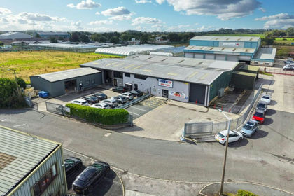
- Price
- Offers in Excess of£1,685,000
- Size
- 0.92 acres
Added on 09/10/2026Industrial Land