Cleobury Road, Far Forest, Kidderminster, Worcestershire
Key Features
- Luxury development opportunity, in the North Worcestershire village of Far Forest, Nr Bewdley, having outline planning consent to construct FOUR LARGE HOMES - namely 2 x 150m2 bungalows (truncated)
Description
Luxury development opportunity, in the North Worcestershire village of Far Forest, Nr Bewdley, having outline planning consent to construct FOUR LARGE HOMES - namely 2 x 150m2 bungalows and 2 x 217m2 houses. what3words:craftsman.creatures.emerge. All enquiries to Nick Millinchip MRICS at STOURPORT OFFICE
AGENTS COMMENTS
This is a very special opportunity indeed, hidden from the road, in the heart of Far Forest just moments from the village pub and shop, within 150m. This forever popular village sits in a highly accessible location about 3.5 miles west of the Georgian riverside town of Bewdley. Another nearby and vibrant local town is Cleobury Mortimer which is about 5 miles. In the immediate surrounding area there are many bridleways offering excellent riding and walking opportunities. This outstandingly beautiful part of North Worcestershire is also dominated by the Wyre Forest National Nature Reserve which spreads out over some 6,000 acres!
THE PROPERTIES (AS DRAWN)
Below are the approximate Gross Internal Area (GIA’s) as per the approved drawing prepared by Central Building Design. The aggregate GIA total is 734m2, as follows:- • Plot 1 = 3-Bedroom Bungalow (150 square metres) • Plot 2 = 4-Bedroom Two Storey Dwelling (217square metres) • Plot 3 = 3-Bedroom Bungalow (150 square metres) • Plot 4 = 4-Bedroom Two Storey Dwelling (217 square metres)
THE PLOT
See appended to these details a ‘plans ahead’, Ordnance Survey based, location plan which was used as part of the planning application. This shows the plot area to be sold edged in red. The access will be shared with the existing property -Orchard House - and therefore access rights for Orchard House will be retained. The approved site plan drawing also illustrates that the existing retaining wall on the access is to be demolished and a new one built.
BACKGROUND
The site has Outline Planning Permission under application number 22/0997/OUT, dated 23 February 2024. A copy of the Decision Notice, along with the approved plans and supporting documents, are available upon request and can also be emailed. The Decision Notice refers to the approved scheme as – “Outline application for the erection of four dwellings with access from A4117 with all other matters reserved. Orchard House Cleobury Road Far Forest”. Also related to 22/0997/OUT is an important appeal decision under APP/R1845/W/24/3342856, dated 1 October 2024. The effect of the appeal decision is that this removes Condition 12 from 22/0997/OUT. The site is currently garden land to Orchard House, DY14 9TE. The seller plans to retain ownership of Orchard House. However, it could be made available by separate negotiation, if desired.
PLANNING
The plot is sold subject to any development plan, tree preservation order, town planning schedule, resolution or notice which may be, or become to be, in force, and subject to any road widening or improvement schemes, land charges and statutory provisions or bylaws without any obligation on the vendors to specify them. Prospective purchasers should satisfy themselves as to all additional costs and the amount thereof.
BOUNDARIES
The purchaser shall be deemed to have full knowledge of all boundaries and neither the vendor nor the vendor's agents will be responsible for defining the boundaries or ownership thereof. The included plan is for identification purposes only. Orchard House will reserve rights of access.
WAYLEAVES, EASEMENTS AND RIGHTS OF WAY
The property and land is sold subject to, and with the benefit of, all easements and quasi-easements and rights of way, declared and undeclared and whether mentioned in these particulars or not. There are no rights to our knowledge.
OVERHEAD POWER LINES
Existing National Grid Electricity Distribution apparatus crosses part of the site. The vendors are in active discussions with NGED regarding the infrastructure and are investigating potential options for repositioning/partial diversion. NGED plans and further information are available to interested parties. Purchasers should satisfy themselves as to the location of existing services and any works required in connection with their proposed development
LOCAL AUTHORITY
Wyre Forest District Council, Wyre Forest House, Finepoint Way, Kidderminster, DY11 7WF Tel:
SERVICES
Potential purchasers should make their own enquiries of the appropriate Statutory Undertakers to ensure the availability of services and the allocated costs for obtaining the same
HEALTH & SAFETY/VIEWINGS
Prospective buyers wishing to walk the grounds should do ONLY IN DAYLIGHT HOURS AND ENTIRELY AT THEIR OWN RISK. In our view it would not be sensible to take children or elderly persons. Appropriate clothing, and footwear, should also be worn and those viewing alone are advised to take a fully charged mobile phone. Please can viewers also notify our office of their attendance beforehand on or email:
DIRECTIONS
From Bewdley town centre pass St. Annes Church to the right hand side and at the box junction turn left into Welch Gate and out onto the Cleobury Road. Continue out onto the Cleobury Road and on entering Callow Hill (A456) pass The Duke William public house and Royal Forrester Public House on the left hand side and at the junction take the right hand turn on to the Cleobury Road (A4117) ; the site will then be found on the right hand side, just after the village shop – SITE - craftsman.creatures.emerge. DRIVEWAY ENTRANCE TO ORCHARD HOUSE – haunt.calibrate.careful
AGENTS NOTE ONE
These particulars are prepared in good faith, but prospective purchasers should make their own detailed enquiries in respect of all Planning / Access / Services / Legal / Valuation / Survey matters, etc. We, as Agents, give no guarantee, or warranty, whatsoever.
AGENTS NOTE TWO
Full searches are already prepared and are available upon request.
PLANNING AGENTS CONTACT DETAILS
Mr. Steve Greybanks, Central Building Design Ltd. .
Map Location
Property details
- Tenure
- Freehold
- Council Tax Band
- TBC
- Date Posted
- 2026-08-28
Utilities & Restrictions
Utilities
- Electricity
- Ask Agent
- Water
- Ask Agent
- Heating
- Ask Agent
- Broadband
- Ask Agent
- Sewerage
- Ask Agent
Rights & Restrictions
- Public Rights of Way
- Ask Agent
- Private Rights of Way
- Ask Agent
- Listed Property
- Ask Agent
- Restrictions
- Ask Agent
Listed status, conservation areas and planning constraints for this location are in the full report.
Property Features
- Accessibility
- Ask Agent
- Parking
- Off-Street Parking
- Garden
- Garden
Beyond the particulars: planning activity, flood history, heritage and ground risks, checked for this exact spot.
Connectivity
Broadband
Fastest speed available at this postcode
80 Mbps
Superfast
Suitable for
- HD streaming
- Video calls
- Web & social
Fixed wireless access may also be an option here.
Mobile signal
Predicted 4G and 5G signal; indoor signal depends on building materials.
Ofcom Connected Nations postcode-level predictions. Speeds and signal are modelled, not measured, and vary between addresses and providers.
Signal is the easy part. Planning activity, flood history and protected designations here are in the full report.
Nearest Schools
Primary
- Far Forest Lea Memorial CofE Primary School93 metresOfsted: Good *
- Ages
- 2 to 11
- Pupils
- 86
- Type
- Academy converter
- Faith
- Church of England
- Bayton CofE Primary School2.5 milesOfsted: Good *
- Ages
- 3 to 11
- Pupils
- 95
- Type
- Voluntary controlled school
- Faith
- Church of England
- St Anne's CofE VC Primary School2.8 milesOfsted: Good *
- Ages
- 2 to 11
- Pupils
- 247
- Type
- Voluntary controlled school
- Faith
- Church of England
- Kinlet CofE Primary School3.6 milesOfsted: Requires improvement *
- Ages
- 4 to 11
- Pupils
- 41
- Type
- Voluntary controlled school
- Faith
- Church of England
- Cleobury Mortimer Primary School3.8 milesOfsted: Good
- Ages
- 2 to 11
- Pupils
- 240
- Type
- Academy converter
Secondary
- The Lacon Childe School3.8 milesOfsted: Requires improvement
- Ages
- 11 to 16
- Pupils
- 563
- Type
- Academy converter
- The Bewdley School3.9 milesOfsted: Good *
- Ages
- 11 to 18
- Pupils
- 970
- Type
- Foundation school
- The Stourport High School and Sixth Form College5.3 milesOfsted: Good
- Ages
- 11 to 18
- Pupils
- 1,039
- Type
- Academy converter
- Baxter College5.5 milesOfsted: Requires improvement *
- Ages
- 11 to 18
- Pupils
- 766
- Type
- Academy converter
- Holy Trinity School6.9 milesOfsted: Good
- Ages
- 4 to 18
- Pupils
- 723
- Type
- Free schools
* Latest graded judgement covers quality of education only; no overall grade was issued under the 2024-25 inspection framework.
Distances are straight-line from the advertised location. Source: the national school registers (DfE, Welsh Government, Scottish Government) and Ofsted.
Schools are just the start: sold prices nearby, planning activity and any flood history are in the full report.
Amenities
Supermarket
GP surgery
Pharmacy
Hospital
Green space
Straight-line distances from the advertised location. Sources: NHS records, Geolytix supermarket locations, OS Open Greenspace and the national trails registers.
The area stacks up? Now check the location itself: planning nearby, protected designations and past flooding.
Getting Around
Nearest station
Nearest bus stop
Typical drive times
Straight-line distances from the advertised location; drive times are typical free-flow times over OpenStreetMap road data, so allow more at peak. Public transport locations from DfT NaPTAN.
Easy to reach matters. So do planning activity, flood history and ground risks: all in the full report.
Flood Risk
Environment Agency open data, checked around the advertised map pin for the listed acreage. Long-term risk counts flood defences; the planning map's flood zones do not. Provided by LandSale, not the listing agent, and not part of the agent's particulars. Risk varies across a holding, so verify before committing.
Rivers and the sea
Planning map: Flood Zone 1.
Surface water
These bandings are the summary. Where this location sits on the flood maps, plus planning activity, heritage and ground risks, is in the full report.
Important notice: Information, maps and tags on this page are drawn from the advertising agent's marketing materials or generated automatically. LandSale has not verified them. Relying on these details is at your own risk, always carry out independent checks before committing to a purchase.
LandSale full disclaimer
Marketing information only - not formal particulars. The details on this website are provided for general guidance and do not constitute an offer or contract. Neither LandSale nor the advertising estate/land agent accepts responsibility for any inaccuracy.
1. Source of information
- Listing content: Core description, asking price, tenure, measurements, photographs and planning history originate from the marketing materials of the advertising estate or land agent. LandSale does not author this content and cannot guarantee its accuracy.
- Automated tags & categorisation: Property type, land-use class, acreage bands and similar labels may be applied by machine-learning models. They are intended as a helpful guide only and may not reflect the property's legal status or permitted use.
- Third-party & enriched data layers: Maps, boundary outlines, planning designations, soil reports, broadband coverage and other environmental or location-based insights are licensed from external suppliers. Such data are supplied “as is", may be incomplete or out of date and are subject to change without notice.
2. Verification required
Prospective purchasers must verify critical matters, including but not limited to planning permission, title boundaries, public rights of way, environmental constraints, acreage, services, access and VAT status, through their own inspections, specialist surveys, legal advisers and the selling agent before relying on the information or entering into any contract.
3. No warranty or liability
LandSale gives no warranty, express or implied, as to the accuracy, completeness or fitness for any particular purpose of the information displayed. LandSale shall not be liable for any loss, damage, cost or expense arising directly or indirectly from any use of or reliance on such information, save where liability may not be excluded by law.
4. Updates & feedback
If you believe any detail on this listing is inaccurate, please let us know. We will investigate and, where appropriate, update the listing or notify the agent.
© LandSale | Version 1.3 - August 2026
Listing agent
Phipps & Pritchard, Stourport
1 High Street, Stourport-On-Severn, Worcestershire, DY13 8DJ
Contact Phipps & Pritchard, Stourport
1 High Street, Stourport-On-Severn, Worcestershire, DY13 8DJ
View agent profileSimilar properties for sale
- Price
- Offers in Region of£795,000
- Size
- 0.91 acres
Added on 01/09/2026Development Land
- Price
- £500,000
- Size
- 1.7 acres
Sapey Common, Upper Sapey, WR6, Upper Sapey, Herefordshire, County of WR6 England
Added on 28/01/2026Building Plot
- Price
- From£595,000
Mistletoe Way, Worcester, WR6, Martley, Worcestershire WR6 England
Added on 29/01/2026Self Build Plot
- Price
- Guide Price£525,000
- Size
- 0.97 acres
Woodcote Green, Bromsgrove, Worcestershire, Dodford with Grafton, Worcestershire B61 England
Added on 08/08/2026Building Plot
- Price
- Offers in Region of£550,000
Hagley Road, Oldswinford, Stourbridge, Stourbridge, Dudley DY8 England
Added on 21/07/2026Development Land
- Price
- £700,000
- Size
- 0.18 acres
Midland Super Cream Premises, Bull Street, Brierley Hill, Stourbridge, Dudley DY5 England
Added on 10/09/2026Industrial Land Added on 07/10/2026Development Land
- Price
- Offers in Region of£550,000
- Size
- 0.5 acres
Land at, 53a Moor Street, Brierley Hill, Dudley, DY5, Stourbridge, Dudley DY5 England
Added on 29/01/2026Development Land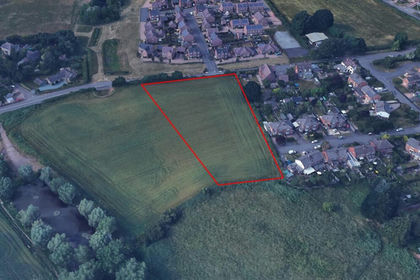
- Price
- Offers Over£750,000
Added on 29/01/2026Development Land
- Price
- Guide Price£495,000
College Road, Bromsgrove, B60, Bromsgrove, Worcestershire B60 England
Added on 24/03/2026Building Plot