Arley, Bewdley
- Land size
- 0.91 acres
- Bedrooms
- 3
- Bathrooms
- 2
Key Features
- Development Project
- Full Planning Permission Approved
- One Executive Barn Conversion (circa 2970 sq ft)
- Three Bedroom Detached Farmhouse (circa 1614 sq ft)
- Detached Storage Building/Car Port
- Gardens & Paddock
- Site extending to around 0.91 acres
- Exceptional Panoramic Views of the Severn Valley & Wyre Forest
Description
TRADITIONAL FARM BUILDINGS WITH FULL PLANNING PERMISSION, PLUS A THREE-BEDROOM FARMHOUSE REQUIRING RENOVATION, ALL SET WITH PANORAMIC SEVERN VALLEY VIEWS.
Description - Halls are delighted with instructions to offer this exciting development opportunity for sale by private treaty.
The sale provides a rare opportunity for developers to acquire a range of attractive traditional farm buildings with Full Planning Permission for conversion into one executive dwelling, extending, in all, 2970sqft (296 sqm) with parking and garden, along with a three bedroom former farmhouse extending to 1614 sq ft (150 sqm) in need of renovation, with panoramic views over the Severn Valley and Wyre Forest.
Accessed from a small country lane, and set within grounds extending to 0.91 acres, the site provides ample space for parking gardens, ensuring the completed units are extremely saleable.
This development opportunity should be of particular interest to developers or possibly owner occupiers with a potential for a family to live in the barn, and a family member to reside in the farmhouse.
Situation - Duttons Farm House and Barns enjoy a superb rural setting in the sought-after area of Upper Arley, surrounded by the beautiful Worcestershire countryside. The property sits within an attractive and peaceful rural landscape, offering a wonderful sense of privacy and tranquillity while remaining well placed for access to the surrounding towns and villages.
Upper Arley is renowned for its picturesque rural character, with rolling countryside, woodland and the River Severn contributing to the area's distinctive appeal. The nearby Arley Arboretum provides a particularly attractive local amenity, while the surrounding countryside offers excellent opportunities for walking, cycling and enjoying the outdoors.
Directions - From the agent's office on the Franche Road, head towards Bridgnorth Road A442, stay on the road for approx 4 miles, turn left onto Lion Lane, after a short distance take a left turn following the lane until reaching a metal gate where the property is on the left hand side.
W3w - ///broached.fluctuate.scared
Schooling - The property lies within a convenient proximity to a number of well regarded state and private schools, including Alveley Primary, Highley Primary School, Upper Arley C of E Primary, Baxter College, Wye Forest School, Heathfield Knoll School, Nurture Learning, and Wribbenhall School.
The Property - Duttons Farmhouse is an attractive three-bedroom detached farmhouse, traditionally constructed of brick beneath a tiled roof and extending to approximately 149.9 sq m (1,613 sq ft).
The property provides well-proportioned accommodation comprising two reception rooms, a kitchen/diner, three bedrooms and a family bathroom. The farmhouse is in need of some modernisation and updating, but remains in a liveable condition, providing a comfortable home while offering an excellent opportunity for a purchaser to improve and personalise the property to their own taste and requirements.
With its detached position and attractive rural setting, Duttons Farmhouse offers the opportunity to create a charming and characterful country home, with scope to enhance the existing accommodation while retaining the property's traditional farmhouse appeal.
Planning Permission - Full Planning Permission for conversion of one traditional farm building to one detached residential dwelling and all associated works was approved by Wyre Forest District Council on 10th February 2026. A full copy of the planning application and associated documentation can be downloaded from Wyre Forest District Council Planning Portal quoting application 25/0862/FUL.
The Barn - Proposed living accommodation comprises
- Entrance Hall
- Large Family Kitchen
- Dining Room
- Living Room
- Snug
- Utility/Boot Room
- Two Ensuite Bedrooms
- Two Further Bedrooms
- Family Bathroom
Outside - The existing Dutch Barn is to be retained and used as a carport/storage.
Services - We are informed that mains water and electricity are available on site or nearby. Drainage will require a new private system. However, all interested parties should satisfy themselves in respect of provision, capacity and suitability of all services with on or off site.
None of the services, appliances or electrical systems have been tested by Halls.
Tenure - The property is said to be of freehold tenure and vacant possession will be give on completion of the purchase.
Local Authority - Wyre Forest District Council, Wyre Forest House, Finepoint Way, Kidderminster, Worcestershire DY11 7WF
Council Tax - The property is being shown as being within council tax band D on the local authority register.
Anti-Money Laundering (Aml) Checks - We are legally obligated to undertake anti-money laundering checks on all property purchasers. Whilst we are responsible for ensuring that these checks, and any ongoing monitoring, are conducted properly; the initial checks will be handled on our behalf by a specialist company, Movebutler, who will reach out to you once your offer has been accepted. The charge for these checks is £36 (including VAT) per purchaser, which covers the necessary data collection and any manual checks or monitoring that may be required. This cost must be paid in advance, directly to Movebutler, before a memorandum of sale can be issued, and is non-refundable. We thank you for your cooperation.
Viewings - By appointment through Halls, Gavel House, 137 Franche Road, Kidderminster DY11 5AP
Map Location
Property details
- Tenure
- Freehold
- Council Tax Band
- D
- Date Posted
- 2026-09-01
Energy Performance Certificate
Energy Efficiency Rating
Based on UK Energy Performance Certificate standards (EU Directive 2002/91/EC)
Running costs are one side. Planning activity, flood history and ground risks for this location are in the full report.
Utilities & Restrictions
Utilities
- Electricity
- Mains
- Water
- Mains
- Heating
- Ask Agent
- Broadband
- Ask Agent
- Sewerage
- Ask Agent
Rights & Restrictions
- Public Rights of Way
- Ask Agent
- Private Rights of Way
- Ask Agent
- Listed Property
- Ask Agent
- Restrictions
- Ask Agent
Listed status, conservation areas and planning constraints for this location are in the full report.
Property Features
- Accessibility
- Ask Agent
- Parking
- Driveway
- Garden
- Garden
Beyond the particulars: planning activity, flood history, heritage and ground risks, checked for this exact spot.
Connectivity
Broadband
Fastest speed available at this postcode
14 Mbps
Standard (10-30 Mbps)
Suitable for
- Web & social
- Music streaming
- Standard video calls
Fixed wireless access may also be an option here.
Mobile signal
Predicted 4G and 5G signal; indoor signal depends on building materials.
Ofcom Connected Nations postcode-level predictions. Speeds and signal are modelled, not measured, and vary between addresses and providers.
Signal is the easy part. Planning activity, flood history and protected designations here are in the full report.
Nearest Schools
Primary
- Upper Arley CofE Primary School1 mileOfsted: Good
- Ages
- 3 to 11
- Pupils
- 81
- Type
- Academy sponsor led
- Faith
- Church of England
- Alveley Primary School2.1 milesOfsted: Good
- Ages
- 4 to 11
- Pupils
- 115
- Type
- Academy sponsor led
- Highley Community Primary School2.8 milesNo Ofsted rating
- Ages
- 5 to 11
- Pupils
- 234
- Type
- Community school
- Franche Primary School3.6 milesOfsted: Requires improvement *
- Ages
- 2 to 11
- Pupils
- 726
- Type
- Community school
- Wolverley Sebright Primary Academy3.6 milesNo Ofsted rating
- Ages
- 3 to 11
- Pupils
- 220
- Type
- Academy converter
Secondary
- Wolverley CofE Secondary School3.4 milesOfsted report card · Feb 2026
- Ages
- 11 to 18
- Pupils
- 964
- Type
- Voluntary controlled school
- Faith
- Church of England
- Baxter College3.9 milesOfsted: Requires improvement *
- Ages
- 11 to 18
- Pupils
- 766
- Type
- Academy converter
- The Bewdley School4.3 milesOfsted: Good *
- Ages
- 11 to 18
- Pupils
- 970
- Type
- Foundation school
- Kinver High School and Sixth Form4.5 milesOfsted: Good
- Ages
- 11 to 18
- Pupils
- 801
- Type
- Academy sponsor led
- Holy Trinity School4.8 milesOfsted: Good
- Ages
- 4 to 18
- Pupils
- 723
- Type
- Free schools
* Latest graded judgement covers quality of education only; no overall grade was issued under the 2024-25 inspection framework.
Distances are straight-line from the advertised location. Source: the national school registers (DfE, Welsh Government, Scottish Government) and Ofsted.
Schools are just the start: sold prices nearby, planning activity and any flood history are in the full report.
Amenities
Supermarket
GP surgery
Pharmacy
Hospital
Straight-line distances from the advertised location. Sources: NHS records, Geolytix supermarket locations, OS Open Greenspace and the national trails registers.
The area stacks up? Now check the location itself: planning nearby, protected designations and past flooding.
Getting Around
Nearest station
Nearest bus stop
Typical drive times
Straight-line distances from the advertised location; drive times are typical free-flow times over OpenStreetMap road data, so allow more at peak. Public transport locations from DfT NaPTAN.
Easy to reach matters. So do planning activity, flood history and ground risks: all in the full report.
Flood Risk
Environment Agency open data, checked around the advertised map pin for the listed acreage. Long-term risk counts flood defences; the planning map's flood zones do not. Provided by LandSale, not the listing agent, and not part of the agent's particulars. Risk varies across a holding, so verify before committing.
Rivers and the sea
Planning map: Flood Zone 1.
Surface water
These bandings are the summary. Where this location sits on the flood maps, plus planning activity, heritage and ground risks, is in the full report.
Important notice: Information, maps and tags on this page are drawn from the advertising agent's marketing materials or generated automatically. LandSale has not verified them. Relying on these details is at your own risk, always carry out independent checks before committing to a purchase.
LandSale full disclaimer
Marketing information only - not formal particulars. The details on this website are provided for general guidance and do not constitute an offer or contract. Neither LandSale nor the advertising estate/land agent accepts responsibility for any inaccuracy.
1. Source of information
- Listing content: Core description, asking price, tenure, measurements, photographs and planning history originate from the marketing materials of the advertising estate or land agent. LandSale does not author this content and cannot guarantee its accuracy.
- Automated tags & categorisation: Property type, land-use class, acreage bands and similar labels may be applied by machine-learning models. They are intended as a helpful guide only and may not reflect the property's legal status or permitted use.
- Third-party & enriched data layers: Maps, boundary outlines, planning designations, soil reports, broadband coverage and other environmental or location-based insights are licensed from external suppliers. Such data are supplied “as is", may be incomplete or out of date and are subject to change without notice.
2. Verification required
Prospective purchasers must verify critical matters, including but not limited to planning permission, title boundaries, public rights of way, environmental constraints, acreage, services, access and VAT status, through their own inspections, specialist surveys, legal advisers and the selling agent before relying on the information or entering into any contract.
3. No warranty or liability
LandSale gives no warranty, express or implied, as to the accuracy, completeness or fitness for any particular purpose of the information displayed. LandSale shall not be liable for any loss, damage, cost or expense arising directly or indirectly from any use of or reliance on such information, save where liability may not be excluded by law.
4. Updates & feedback
If you believe any detail on this listing is inaccurate, please let us know. We will investigate and, where appropriate, update the listing or notify the agent.
© LandSale | Version 1.3 - August 2026

Listing agent
Halls Estate Agents, Kidderminster
137 Franche Road, Kidderminster, DY11 5AP
Contact Halls Estate Agents, Kidderminster
137 Franche Road, Kidderminster, DY11 5AP
View agent profileSimilar properties for sale
- Price
- Offers in Region of£795,000
- Size
- 1 acres
Wergs Hall Gardens, Wergs Hall Road, Tettenhall, Codsall, Staffordshire WV8 England
Added on 29/01/2026Development Land
- Price
- Guide Price£850,000
Added on 27/08/2026Redevelopment Land
- Price
- Offers in Region of£750,000
Added on 20/03/2026Development Land
- Price
- Guide Price£950,000
Rosecroft, Orleton, Ludlow, Shropshire, Orleton, Herefordshire, County of SY8 England
Added on 20/07/2026Historic House
- Price
- Guide Price£750,000
- Size
- 0.46 acres
Added on 17/07/2026Development Land
- Price
- Offers in Region of£950,000
Tidbury Green Garage, Lowbrook Lane, Earlswood, Solihull, B90, Tidbury Green, Solihull B90 England
Added on 17/07/2026Workshop
- Price
- Guide Price£900,000
- Size
- 2 acres
Dorset, Vale Avenue, Walsall, Aldridge-Brownhills, Walsall WS9 England
Added on 07/09/2026Development Land
- Price
- £800,000
- Size
- 2.95 acres
Added on 29/01/2026Development Land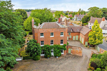
- Price
- Guide Price£950,000
- Size
- 1.23 acres
Dorrington House, Dorrington, Shrewsbury, Shropshire, Condover, Shropshire SY5 England
Added on 05/03/2026Historic House Added on 29/01/2026Development Land