Meend Farm, Turners Tump, Ruardean, GL17
- Land size
- 21.19 acres
- Bedrooms
- 3
- Bathrooms
- 1
Key Features
- Excellent rural situation and position adjacent to Meend Lane
- Walking distance to the village of Ruardean
- Good accessibility to the A40, A449 and M50 at Ross-on-Wye
- Spacious detached three-bedroom bungalow which is subject to an Agricultural Occupancy Condition (AOC)
- Traditional stone and brick two storey barn with potential
- Extensive ringfenced compartment of level to gently undulating pastureland
- Appealing to lifestyle, equestrian, agricultural development and rural enterprise purchasers
- Available Freehold with Vacant Possession
- Extending as a whole to approximately 21.19 acres (8.57 hectares)
Description
Meend Farm comprises a sought-after smallholding and redevelopment package with detached three-bedroom bungalow which is subject to an Agricultural Occupancy Condition (AOC) in need of modernisation and detached traditional stone and brick barn with potential set within a ringfenced compartment of productive pastureland extending in all to 21.19 acres (8.57 hectares).
The property provides an excellent package for anyone looking for a smallholding project, ideal for any buyer with small scale pedigree livestock / equestrian and development interests.
• Excellent rural situation and position adjacent to Meend Lane •
• Walking distance to the village of Ruardean •
• Good accessibility to the A40, A449 and M50 at Ross-on-Wye •
• Spacious detached three-bedroom bungalow which is subject to an Agricultural Occupancy Condition (AOC) •
• Traditional stone and brick two storey barn with potential •
• Extensive ringfenced compartment of level to gently undulating pastureland •
• Appealing to lifestyle, equestrian, agricultural development and rural enterprise purchasers •
• Available Freehold with Vacant Possession •
• Extending as a whole to approximately 21.19 acres (8.57 hectares) •
DISTANCES FROM MEEND FARM
Ruardean 0.4 miles • Cinderford 3.9 miles • Coleford 6.1 miles
Ross-on-Wye 7.5 miles • Monmouth 10.6 miles • Lydney 11.1 miles
Gloucester 16.5 miles • Chepstow 19.1 miles
Bristol 36.6 miles • London 129 miles
Lydney Railway Station 11.7 miles • Gloucester Railway Station 16.5 miles
Bristol Parkway Railway Station 32 miles
Bristol Airport 45 miles • London Heathrow Airport 115 miles
(all distances are approximate)
LOCATION & SITUATION
Meend Farm enjoys an excellent location close to the village of Ruardean with easy accessibility to the local amenities / facilities of Ruardean yet benefiting from a rural position that has a pleasant outlook. The property enjoys wonderful views over the surrounding countryside.
Ruardean’s amenities include a post office with a general store, a primary school, a doctor’s surgery, a parish church and a public house.
Cinderford, less than four miles from the property and is a thriving old mining town highly regarded for its extensive range of local facilities, amenities, employment and educational establishments as well as the renowned Cinderford Rugby Club.
The town of Monmouth is less than 11 miles from the property and boasts excellent schools including Haberdashers’ Monmouth School, Llangattock School Monmouth with Montessori Nursery, a variety of primary schools and Monmouth Comprehensive School. Monmouth also offers an upmarket traditional shopping street, with boutique shops, Waitrose supermarket, M&S Simply Food, The Savoy Theatre and an extensive range of recreational and leisure facilities. An abundance of tourism and recreational activities exist within Monmouth and the wider region.
Gloucester is just 16.5 miles away from the property with all the benefits a city has to offer, such as a bustling Hight Street, Gloucester Quays shopping district, Gloucester University and Gloucester Rugby Club who play in the Rugby Premiership, England’s top division of rugby, as well as in European competitions. Gloucester Cathedral is one of the finest examples of gothic architecture in the UK and Cheltenham Racecourse is just seven miles from the city, host to the world renowned Gold Cup.
THE BUNGALOW
Accessed from the western side of Meend Lane a gated entrance leads to the bungalow. The bungalow is thought to be a 1970’s construction and is subject to an Agricultural Occupancy Condition (AOC). The bungalow features stone and brick elevations under a pitched tiled roof.
Internally the property compromises a kitchen with base and wall units, composite worktop with metal sink, free-standing oven and double aspect windows with views of the land.
To the side of the kitchen is a boot room with cloakroom with wc and utility.
From the kitchen a central corridor provides access to an extensive sitting room with feature fireplace, wooden boarded floor and sliding glazed doors providing access and views of the land.
Also accessed from the corridor are a family bathroom with bath with overhead shower, wc and wash basin, three double bedrooms and the front hallway with external door to the garden.
The bungalow is in need of gentle modernisation but is extensive providing a spacious detached three-bedroom family home with potential.
The property is serviced by mains water and electricity. Central heating is via an oil-fired boiler with foul drainage to a septic tank.
Externally the immediate garden area surrounds the bungalow and is predominantly laid to lawn with views over the land to the rear.
The bungalow is in need of modernisation but has an extensive layout providing a spacious three-bedroom property with potential in a fantastic location offering an exciting prospect for any purchaser.
TRADITIONAL BARN
Positioned north of the bungalow and detached from it is a useful traditional stone and brick barn with two ground level rooms and a hayloft above which is accessed from an external stone staircase. The barn is in a good condition. In its current state it could provide useful storage, stabling or cover for stock but could have potential to be used for a range of possible uses subject to obtaining the necessary planning consent.
LAND
The land at Meend Farm extends out to the west of the bungalow and can be independently accessed from an independent access track positioned to the south-east of the bungalow.
The land is set over three field enclosures. The easternmost field enclosure adjacent to the bungalow is a level fenced paddock with two extensive field enclosures beyond, which are gently sloping to gently undulating, but could be subdivided to create further field enclosures. One of the extensive field enclosures features a capped mine shaft with another featuring two ponds. All the land is stock proof fenced permanent pasture over freely draining slightly acid loamy soils and can be grazed or mown for fodder.
The land is in good condition providing a perfect land holding for anyone with a pony or rare breed stock.
As property is easily accessible and offering an exciting project it would certainly provide significant appeal to agricultural, equestrian and development type purchasers or anyone with hobby farming interests.
In total the land and property at Meend Farm extends to approximately 21.19 acres (8.57 hectares).
KEY INFORMATION
Services: The property is connected to mains water and electricity. The property is centrally heated via an oil-fired boiler. Foul drainage is to a septic tank. Any interested parties are to make and rely upon their own enquiries regarding any utility or service connections to the site.
Wayleaves & Easements: The property is sold subject to all existing Wayleaves & Easements that may exist at the date of sale. Any interested parties are to make and rely upon their own enquiries, regarding Wayleaves & Easements.
Sale Method: Meend Farm is available For Sale by Private Treaty. The Vendor & Selling Agents reserve the right to conclude the sale by any alternative Sale Method.
Fixtures and Fittings: Only those items specifically mentioned in these particulars will be included in the sale, the remainder are excluded from the sale, however, may be available by separate negotiation.
Council Tax Band: C.
Local Planning Authority: Forest of Dean District Council: .
Viewings: Strictly by appointment with the selling agents.
Directions: From Ruardean High Street proceed south on School Road signposted Ruardean/Woodside. After 0.1 miles keep left onto Turners Tump. Proceed straight, continuing on Turners Tump which will turn into Meend Lane for approximately 0.3 miles and the property will be on your right-hand side.
WHAT 3 WORDS
///bespoke.being.majors
Map Location
Property details
- Tenure
- Ask Agent
- Council Tax Band
- Ask Agent
- Date Posted
- 2026-08-26
Market Value Analysis
Compared with 91 Farms & Smallholdings listings in South West England (10+ acres).
Utilities & Restrictions
Utilities
- Electricity
- Ask Agent
- Water
- Ask Agent
- Heating
- Ask Agent
- Broadband
- Ask Agent
- Sewerage
- Ask Agent
Rights & Restrictions
- Public Rights of Way
- Ask Agent
- Private Rights of Way
- Ask Agent
- Listed Property
- Ask Agent
- Restrictions
- Ask Agent
Listed status, conservation areas and planning constraints for this location are in the full report.
Property Features
- Accessibility
- Ask Agent
- Parking
- Ask Agent
- Garden
- Garden
Beyond the particulars: planning activity, flood history, heritage and ground risks, checked for this exact spot.
Connectivity
Broadband
Fastest speed available at this postcode
1.8 Gbps
Gigabit full fibre · available to 94% of premises
Suitable for
- 4K streaming on every screen
- Full-time home working
- Online gaming & big downloads
Mobile signal
Predicted 4G and 5G signal; indoor signal depends on building materials.
Ofcom Connected Nations postcode-level predictions. Speeds and signal are modelled, not measured, and vary between addresses and providers.
Signal is the easy part. Planning activity, flood history and protected designations here are in the full report.
Nearest Schools
Primary
- Ruardean Church of England Primary School201 metresOfsted: Good
- Ages
- 4 to 11
- Pupils
- 76
- Type
- Voluntary controlled school
- Faith
- Church of England
- Woodside Primary School0.7 milesNo Ofsted rating
- Ages
- 5 to 11
- Pupils
- 122
- Type
- Community school
- Drybrook Primary School1.4 milesOfsted: Requires improvement *
- Ages
- 2 to 11
- Pupils
- 147
- Type
- Academy sponsor led
- Lydbrook Primary School1.7 milesNo Ofsted rating
- Ages
- 2 to 11
- Pupils
- 83
- Type
- Community school
- Steam Mills Primary School1.8 milesOfsted report card · Jun 2026
- Ages
- 4 to 11
- Pupils
- 128
- Type
- Community school
Secondary
- Dene Magna and Sixth Form2.9 milesOfsted: Good *
- Ages
- 11 to 18
- Pupils
- 1,020
- Type
- Academy converter
- SGS Forest High School3 milesOfsted: Requires improvement
- Ages
- 11 to 16
- Pupils
- 255
- Type
- Academy sponsor led
- Five Acres High School4 milesOfsted report card · Jun 2026
- Ages
- 11 to 16
- Pupils
- 786
- Type
- Academy sponsor led
- John Kyrle High School and Sixth Form Centre Academy5 milesOfsted: Good *
- Ages
- 11 to 18
- Pupils
- 1,274
- Type
- Academy converter
- Newent Community School and Sixth Form Centre7.8 milesNo Ofsted rating
- Ages
- 11 to 18
- Pupils
- 976
- Type
- Academy converter
* Latest graded judgement covers quality of education only; no overall grade was issued under the 2024-25 inspection framework.
Distances are straight-line from the advertised location. Source: the national school registers (DfE, Welsh Government, Scottish Government) and Ofsted.
Schools are just the start: sold prices nearby, planning activity and any flood history are in the full report.
Amenities
Supermarket
GP surgery
Pharmacy
Hospital
Green space
Straight-line distances from the advertised location. Sources: NHS records, Geolytix supermarket locations, OS Open Greenspace and the national trails registers.
The area stacks up? Now check the location itself: planning nearby, protected designations and past flooding.
Getting Around
Nearest station
Nearest bus stop
Typical drive times
Straight-line distances from the advertised location; drive times are typical free-flow times over OpenStreetMap road data, so allow more at peak. Public transport locations from DfT NaPTAN.
Easy to reach matters. So do planning activity, flood history and ground risks: all in the full report.
Flood Risk
Environment Agency open data, checked around the advertised map pin for the listed acreage. Long-term risk counts flood defences; the planning map's flood zones do not. Provided by LandSale, not the listing agent, and not part of the agent's particulars. Risk varies across a holding, so verify before committing.
Rivers and the sea
Planning map: Flood Zone 1.
Surface water
Not at the pin: mapped about 140 metres away.
These bandings are the summary. Where this location sits on the flood maps, plus planning activity, heritage and ground risks, is in the full report.
Important notice: Information, maps and tags on this page are drawn from the advertising agent's marketing materials or generated automatically. LandSale has not verified them. Relying on these details is at your own risk, always carry out independent checks before committing to a purchase.
LandSale full disclaimer
Marketing information only - not formal particulars. The details on this website are provided for general guidance and do not constitute an offer or contract. Neither LandSale nor the advertising estate/land agent accepts responsibility for any inaccuracy.
1. Source of information
- Listing content: Core description, asking price, tenure, measurements, photographs and planning history originate from the marketing materials of the advertising estate or land agent. LandSale does not author this content and cannot guarantee its accuracy.
- Automated tags & categorisation: Property type, land-use class, acreage bands and similar labels may be applied by machine-learning models. They are intended as a helpful guide only and may not reflect the property's legal status or permitted use.
- Third-party & enriched data layers: Maps, boundary outlines, planning designations, soil reports, broadband coverage and other environmental or location-based insights are licensed from external suppliers. Such data are supplied “as is", may be incomplete or out of date and are subject to change without notice.
2. Verification required
Prospective purchasers must verify critical matters, including but not limited to planning permission, title boundaries, public rights of way, environmental constraints, acreage, services, access and VAT status, through their own inspections, specialist surveys, legal advisers and the selling agent before relying on the information or entering into any contract.
3. No warranty or liability
LandSale gives no warranty, express or implied, as to the accuracy, completeness or fitness for any particular purpose of the information displayed. LandSale shall not be liable for any loss, damage, cost or expense arising directly or indirectly from any use of or reliance on such information, save where liability may not be excluded by law.
4. Updates & feedback
If you believe any detail on this listing is inaccurate, please let us know. We will investigate and, where appropriate, update the listing or notify the agent.
© LandSale | Version 1.3 - August 2026
Listing agent
Powells, Monmouth
Singleton Court Business Park, Wonastow Road, Monmouth, NP25 5JA
Contact Powells, Monmouth
Singleton Court Business Park, Wonastow Road, Monmouth, NP25 5JA
View agent profileSimilar properties for sale
- Price
- Offers in Excess of£470,000
- Size
- 1.2 acres
Camomile Green, Lydbrook, Gloucestershire, GL17, Lydbrook, Gloucestershire GL17 England
Added on 08/10/2026House with Land
- Price
- Guide Price£650,000
- Size
- 8.01 acres
Holly Bushes, Llwyn-y-Celyn Farm, Shirenewton, Chepstow, NP16, Shirenewton, Monmouthshire NP16 Wales
Added on 29/01/2026Smallholding
- Price
- Guide Price£675,000
- Size
- 14.67 acres
The Coed Lot 1, Cwmyoy, Abergavenny, Monmouthshire, NP7, Crucorney, Monmouthshire NP7 Wales
Added on 11/09/2026Smallholding
- Price
- Guide Price£475,000
- Size
- 1.93 acres
Llanhennock, Newport, NP18, Llangybi, Monmouthshire NP18 Wales
Added on 12/09/2026House with Land
- Price
- Guide Price£640,000
- Size
- 8.35 acres
Ford Bridge, Nr Leominster, Leominster, Herefordshire, County of HR6 England
Added on 28/03/2026Smallholding
- Price
- Guide Price£625,000
- Size
- 3.85 acres
Brilley, Whitney On Wye Hereford HR3, Brilley, Herefordshire, County of HR3 England
Added on 09/07/2026Smallholding
- Price
- Guide Price£650,000
- Size
- 4.57 acres
Gwerna Hall Farm Lot 1, Pandy Lane, Maesycwmmer, Hengoed, CF82, Maesycwmmer, Caerphilly CF82 Wales
Added on 10/07/2026Smallholding
- Price
- Guide Price£685,000
- Size
- 3.7 acres
Penrhiwceiber Farm, Llanwonno Road Mountain Ash, CF45, Penrhiwceiber, Rhondda Cynon Taf CF45 Wales
Added on 29/01/2026Farmhouse
- Price
- Guide Price£550,000
- Size
- 3.02 acres
1, Landraw Road Pontypridd CF37, Pontypridd Town, Rhondda Cynon Taf CF37 Wales
Added on 09/09/2026Smallholding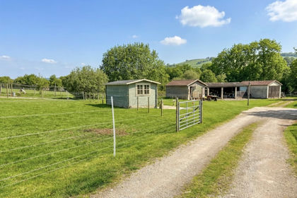
- Price
- Offers in Excess of£500,000
- Size
- 2.2 acres
Added on 08/10/2026Development Land