Woodland, Nr Ashburton
- Bedrooms
- 3
- Bathrooms
- 2
Key Features
- Hall
- Cloaks/Utility
- Living Room with Wood-Burner
- Conservatory-Dining Room
- Stylish Kitchen-Breakfast Room
- Three Double Bedrooms
- Bathroom
- Shower Room
- Attractively Landscaped Patio Gardens
- Two Garages and Parking for Two Cars
Description
In a tucked-away setting in the heart of the countryside, Butlers Retreat is a light and airy conversion of a two-storey period building, originally stable buildings to Wickeridge House, offering a unique home with particularly spacious room sizes.
The flexible and very well presented accommodation combines the character of an older building with the comforts and specification for modern-day life. The living room has a wood burning stove and there is propane gas fired heating via radiators. The windows are mainly double glazed, and several rooms enjoy pleasant outlooks over the gardens and countryside. We understand there are PV panels to the garage roof and that the roof covering of the house was replaced in recent years.
The gardens wrap around the property and have been laid out for ease of maintenance. They include various paved courtyards, and gravelled areas interspersed with raised beds. Ample parking is provided by the two garages and adjoining parking areas. plus designated visitor's parking.
Butlers Retreat is approached over a long imposing drive, shared with a handful of properties, which leads off the Ashburton to Woodland Road, and is within walking distance of the Rising Sun country inn. Whilst set in rolling countryside, the property is highly accessible, being less than two miles from the A38 Expressway, bringing Exeter and Plymouth within easy commuting distance. The local towns of Ashburton, Newton Abbot and Totnes each provide a good range of everyday shops and amenities and the scenic landscape of Dartmoor National Park is close to hand.
Council Tax Band: Band E at the time of preparing these particulars
Tenure: Freehold
Hall
Part glazed entrance door. Tiled flooring. Window with tiled sill. Radiator. Part glazed door to the garden. Steps down to lower ground floor and steps up to kitchen.
Cloakroom/Utility
White WC and wash basin. Tiled flooring as in the hall. Worktop with plumbing for washing machine beneath and space for dryer. Wall cupboard. Radiator/towel rail. Obscure glazed window. Extractor.
Living Room
Windows at either end including a door to the garden. Engineered wood flooring. Villager wood burning stove on polished granite hearth. Radiator. Wide timber door with ornate etched glass panels to
Conservatory-Dining Room
Windows on three sides with views over the garden. French doors opening to the garden. Wall mounted electric heater.
Kitchen/Breakfast Room
Fitted with a range of grey fronted of units with wood-finish worktops. White butlers-style sink. Integrated dishwasher. Belling farmhouse style cooker with filter hood over. Engineered wood flooring. Two radiators. Window overlooking the garden. Large secondary double glazed sash window to end wall and two further windows. Stairs to lower ground floor. Hatch to loft space with useful storage space.
Inner Landing
with door to bedroom one and stairs to the lower ground floor.
Bedroom 1
Two windows with far reaching outlook over countryside. Radiator. Part glazed door to
En-Suite Bathroom
White suite of bath with shower over and glazed screen, wash basin inset to top with cupboard beneath and WC. Wall cupboard. Tiled walls around bath, basin and WC. Radiator/towel rail. Velux roof window. Tiled floor. Extractor.
Lower Ground Floor
Hall
Window with tiled sill. Radiator. Understairs storage cupboard. Part glazed door to outside.
Bedroom 2
Window overlooking the front entrance area. Radiator.
Shower Room
White suite of shower cubicle with glazed enclosure, wash basin with cupboard beneath and WC. Radiator/towel rail. Fully tiled walls. Tiled floor. Extractor.
Bedroom 3
Feature arched window overlooking the courtyard. Radiator. Window with tiled sill. Door and tiled steps to the main entrance hall.
Outside
Butlers Retreat is approached over a long driveway shared with Wickeridge House and the neighbouring dwellings. The drive for Wickeridge Mews forks to the right and this is where, on the right, the two garages are. Each have individual up and over doors, loft storage area, power/light connected and personal doors at the rear to a useful outside covered storage area.
The property is situated opposite the garages, across the shared courtyard drive. A metal pedestrian gate for Butlers Retreat opens to a gravelled reception area and paved path leading to the main entrance.
Garden
The gardens have been attractively laid out in a courtyard style, with various paved and gravelled areas for sitting out and ideal for container plants and with raised beds.
The garden has direct pedestrian access to the drive, and a boiler room which houses the boiler, and with electric light, power and dry storage. There are two log stores.
Directions
Travelling west towards Plymouth on the A38, take the road signposted Woodland and Denbury which is located between the Goodstone/Caton slip road and the first Ashburton turn off at Linhay. Proceed along this lane for 1.4 miles and the driveway for Wickeridge House and Mews will be found on the right (before you reach the Rising Sun Inn). Go down the drive and at the end bear right. Once in the courtyard, the garages will be seen in the top right hand corner, with Butlers Retreat on the left. Please park in the visitors spaces on the left.
Additional Information
Mains water and electric. Septic tank drainage and LPG gas fired heating.
Standard broadband should be available, as per Ofcom website. We have been advised by the sellers that they currently have Starlink broadband. Mobile signal ranges from good outdoor to variable outdoor, as per Ofcom website.
Anti-Money Laundering (AML) Compliance
To comply with UK Anti Money Laundering legislation, all estate agents are required to complete ID verification checks on all sellers and buyers, to apply ongoing monitoring until the transaction ends and to verify the legitimate source of funds of every buyer. We conduct these checks through an independent specialist service provider, alongside our own internal due diligence, and there is a fee of £24 (£20 plus VAT) per person. This is not a credit check so it will have no effect on your credit history.
Map Location
Property details
- Tenure
- Freehold
- Council Tax Band
- E
- Date Posted
- 2026-08-26
Energy Performance Certificate
Energy Efficiency Rating
Based on UK Energy Performance Certificate standards (EU Directive 2002/91/EC)
View official EPC certificate ↗
Running costs are one side. Planning activity, flood history and ground risks for this location are in the full report.
Utilities & Restrictions
Utilities
- Electricity
- Ask Agent
- Water
- Ask Agent
- Heating
- Ask Agent
- Broadband
- Ask Agent
- Sewerage
- Ask Agent
Rights & Restrictions
- Public Rights of Way
- Ask Agent
- Private Rights of Way
- Ask Agent
- Listed Property
- Ask Agent
- Restrictions
- Ask Agent
Listed status, conservation areas and planning constraints for this location are in the full report.
Property Features
- Accessibility
- Ask Agent
- Parking
- Parking Available
- Garden
- Garden
Beyond the particulars: planning activity, flood history, heritage and ground risks, checked for this exact spot.
Connectivity
Broadband
Fastest speed available at this postcode
6 Mbps
Under 10 Mbps here
Suitable for
- Basic browsing & email
Fixed wireless access may also be an option here.
Mobile signal
Predicted 4G and 5G signal; indoor signal depends on building materials.
Ofcom Connected Nations postcode-level predictions. Speeds and signal are modelled, not measured, and vary between addresses and providers.
Signal is the easy part. Planning activity, flood history and protected designations here are in the full report.
Nearest Schools
Primary
- Ashburton Primary School1.8 milesOfsted: Good
- Ages
- 4 to 11
- Pupils
- 161
- Type
- Academy converter
- Landscove Church of England Primary School2.2 milesOfsted: Good
- Ages
- 4 to 11
- Pupils
- 91
- Type
- Academy converter
- Faith
- Church of England
- Denbury Primary School2.2 milesOfsted: Good
- Ages
- 2 to 11
- Pupils
- 111
- Type
- Community school
- Broadhempston Village Primary School2.3 milesOfsted: Good *
- Ages
- 4 to 11
- Pupils
- 43
- Type
- Academy converter
- Blackpool Church of England Primary School3.2 milesOfsted: Good
- Ages
- 4 to 11
- Pupils
- 244
- Type
- Academy converter
- Faith
- Church of England
Secondary
- South Dartmoor Community College1.7 milesOfsted: Good *
- Ages
- 11 to 18
- Pupils
- 801
- Type
- Academy converter
- Coombeshead Academy4.3 milesOfsted: Good
- Ages
- 11 to 18
- Pupils
- 870
- Type
- Academy converter
- Newton Abbot College4.5 milesOfsted: Good *
- Ages
- 11 to 18
- Pupils
- 1,108
- Type
- Academy converter
- South Devon UTC4.9 milesOfsted report card · Feb 2026
- Ages
- 14 to 19
- Pupils
- 184
- Type
- University technical college
- King Edward VI Community College5.3 milesNo Ofsted rating
- Ages
- 11 to 18
- Pupils
- 940
- Type
- Academy converter
* Latest graded judgement covers quality of education only; no overall grade was issued under the 2024-25 inspection framework.
Distances are straight-line from the advertised location. Source: the national school registers (DfE, Welsh Government, Scottish Government) and Ofsted.
Schools are just the start: sold prices nearby, planning activity and any flood history are in the full report.
Amenities
Supermarket
GP surgery
Pharmacy
Hospital
Straight-line distances from the advertised location. Sources: NHS records, Geolytix supermarket locations, OS Open Greenspace and the national trails registers.
The area stacks up? Now check the location itself: planning nearby, protected designations and past flooding.
Getting Around
Nearest station
Nearest bus stop
Typical drive times
Straight-line distances from the advertised location; drive times are typical free-flow times over OpenStreetMap road data, so allow more at peak. Public transport locations from DfT NaPTAN.
Easy to reach matters. So do planning activity, flood history and ground risks: all in the full report.
Flood Risk
Environment Agency open data, checked around the advertised map pin for the listed acreage. Long-term risk counts flood defences; the planning map's flood zones do not. The map pin for this listing marks the postcode area rather than the exact location, so these readings describe the surrounding area. Provided by LandSale, not the listing agent, and not part of the agent's particulars. Risk varies across a holding, so verify before committing.
Rivers and the sea
Planning map: Flood Zone 1.
Surface water
These bandings are the summary. Where this location sits on the flood maps, plus planning activity, heritage and ground risks, is in the full report.
Important notice: Information, maps and tags on this page are drawn from the advertising agent's marketing materials or generated automatically. LandSale has not verified them. Relying on these details is at your own risk, always carry out independent checks before committing to a purchase.
LandSale full disclaimer
Marketing information only - not formal particulars. The details on this website are provided for general guidance and do not constitute an offer or contract. Neither LandSale nor the advertising estate/land agent accepts responsibility for any inaccuracy.
1. Source of information
- Listing content: Core description, asking price, tenure, measurements, photographs and planning history originate from the marketing materials of the advertising estate or land agent. LandSale does not author this content and cannot guarantee its accuracy.
- Automated tags & categorisation: Property type, land-use class, acreage bands and similar labels may be applied by machine-learning models. They are intended as a helpful guide only and may not reflect the property's legal status or permitted use.
- Third-party & enriched data layers: Maps, boundary outlines, planning designations, soil reports, broadband coverage and other environmental or location-based insights are licensed from external suppliers. Such data are supplied “as is", may be incomplete or out of date and are subject to change without notice.
2. Verification required
Prospective purchasers must verify critical matters, including but not limited to planning permission, title boundaries, public rights of way, environmental constraints, acreage, services, access and VAT status, through their own inspections, specialist surveys, legal advisers and the selling agent before relying on the information or entering into any contract.
3. No warranty or liability
LandSale gives no warranty, express or implied, as to the accuracy, completeness or fitness for any particular purpose of the information displayed. LandSale shall not be liable for any loss, damage, cost or expense arising directly or indirectly from any use of or reliance on such information, save where liability may not be excluded by law.
4. Updates & feedback
If you believe any detail on this listing is inaccurate, please let us know. We will investigate and, where appropriate, update the listing or notify the agent.
© LandSale | Version 1.3 - August 2026
Listing agent
Howard Douglas, Ashburton
2 North Street, Ashburton, TQ13 7QD
Similar properties for sale
 Added on 09/10/2026Barn Conversion
 Added on 18/08/2026Barn Conversion
- Price
- Guide Price£650,000
- Size
- 1 acres
Added on 28/09/2026House with Land
- Price
- Guide Price£675,000
- Size
- 0.25 acres
Added on 27/03/2026Barn Conversion Added on 11/09/2026Barn Conversion
- Price
- £685,000
- Size
- 1.17 acres
Added on 29/01/2026House with Land
- Price
- £650,000
Added on 14/09/2026Barn Conversion
- Price
- Guide Price£450,000
Added on 13/03/2026Barn Conversion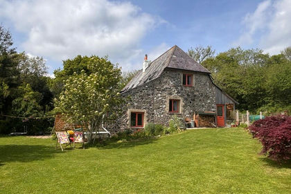
- Price
- Offers in Excess of£620,000
Added on 14/02/2026Barn Conversion
- Price
- Guide Price£660,000
Added on 17/06/2026Barn Conversion