Land off Stoke Charity Road, Kings Worthy, Hampshire
- Land size
- 39.11 acres
Key Features
- SEE AND PRINT PDF SALES PARTICULARS AVAILABLE BELOW
- SEE DRONE VIDEO FOOTAGE ON THE VIRTUAL TOUR TAB
- APPROX. 39.11 ACRES (15.83 HA) IN ALL
- AGRICULTURAL PASTURE LAND
- AVAILABLE AS A WHOLE IN UP TO 9 LOTS
- SINGLE BLOCK
- ELEVATED POSITION AND GENTLY SLOPING
- WELL DRAINED
- SUITABLE FOR ALTERNATIVE USES, SUBJECT TO PLANNING
- SERVICES AVAILABLE
Description
VIEWING INSTRUCTIONS: Strictly by Prior Arrangement Only. Contact Selling Agent to book an appointment.
Car Parking for Parties on Viewing Appointment: Park at Position D on the Site Plan, in front of the metal gate. Please do not park on the gravel access track between C and D.
PLEASE DO NOT PARK ALONG THE TARMAC ENTRANCE ROAD – THIS ROUTE IS IN CONSTANT USE.
HEALTH & SAFETY – WHEN VIEWING – PLEASE DO NOT ENTER ANY PARCEL WHICH CONTAINS HORSES. PLEASE DO NOT APPROACH ANY HORSE.
Security: The gates at B and D on the Site Plan are locked which provide access to the Property and no interested party has authority to access the land in any way and without a prior appointment with the Selling Agent.
VIDEO DRONE FOOTAGE: See the Selling Agent's website for further details, photographs, drone video footage is available showing the whole Property.
See Location Plan on which the Property is shaded red.
DIRECTIONS: Please see Location Plan and use postcode SO21 2RP and What3Words – Property is off Stoke Charity Road.
DESCRIPTION: The Property extends in all to approx. 39.11 acres (15.83 Ha) and comprises agricultural Pasture Land with approx. 13.69 acres (Lots 1 – 6) currently used for grazing of horses, with the remaining 24.99 acres (Lots 7 - 9) cropped and unfenced.
The land is shown as Grade 3 on the Agricultural Land Classification. The Subsoils are indicated to be of Chalk – ‘shallow well drained calcareous silty soils over chalk on slopes and crests’ on the Geological Survey Plan. The land lies approx. 100m above sea level and gently slopes down to the south.
LAND REGISTRY: All of the Property is registered as part of Title Number HP371. See Land Registry Register and Plan available on Selling Agent’s website.
SERVICES: There is a Mains Water is connection at point C on the plan. The Vendor will grant rights to enable additional connections, if required, subject to a successful application by any purchaser to Southern Water. There is an Electrical Substation on the Vendors retained land. . The Property will benefit from the right to connect by crossing other adjoining land owned by the Vendor if needed subject to SSE agreement to supply power
ACCESS: The Property benefits from a Right of Way at all times and for all purposes off the Public Highway and over the Tarmac Access Road and track between positions A, B, C and D as shown on the Site Plan.
AGRICULTURAL PASTURE LAND: Lots 1 – 6 – This land has been grazed in rotation by horses in recent years. The land is subdivided by wooden posts and electric tape and electric battery used when grazing occurs. There are existing plastic water troughs on site serving Lots 1 – 6.
Lots 7 – 9 have not been grazed by horses and in recent years the grass crop is harvested as hay or haylage.
Within Lot 8 there is believed to be historic building material. This area of the pasture is currently uncut (2026). The Vendor has no knowledge of any detail of the material but it is believed to be ‘inert’. The affected area is estimated to be approx. 1.35 acres as approximately identified at the northern end of Lot 8 hatched on the Site Plan and shown on photographs and within drone video footage.
ACCESS RIDE: There is an unsurfaced access ride (shaded yellow) between position B and E on the Site Plan approx. 3.5m width between post and electric tape fencings which provides access to the various grazed parcels of pasture land.
ACCESS TRACK - Lots 8 and 9 ONLY: There is an existing vehicular track between position D and F on the Site Plan and positioned close to the railway line. This will provide access to Lots 8 and 9 only.
CURRENT OCCUPATION OF THE LAND: The land is currently rented and grazed by a neighbouring equestrian yard ‘Cherry Tree Stables’. The Vendor has served Notice on this Tenant to vacate the land. Their occupation and use continues through this marketing campaign.
The Tenant owns the following fencing and equipment on the Property, and so has the ability to remove these items when they vacate:
Wooden posts, electric tape fencing and fittings. Electric Batteries.
Plastic water troughs (10 in total) and associated water pipes laid.
Metal gate at northern end of ‘Access Ride’ and wooden gate at position B.
DESIGNATIONS: No ecological designations affect the Property.
VACANT POSSESSION OF THE PROPERTY: The property will be sold with Vacant Possession on completion. The Vendor is prepared to discuss with the outgoing tenant the retention of fencing, water troughs and gates if required.
TPOs: None affect the Property.
PUBLIC RIGHTS OF WAY: No Public Footpaths or any other Public routes cross the Property.
WAYLEAVES AND EASEMENTS: No cables, wire or pipelines cross the Property.
THE RIGHT TO CONNECT TO SERVICES: The Property benefits from the right to connect into existing (e.g. water and electricity) and future services laid in the roadway and track between positions A, B, C and D).
POTENTIAL NEW GATEWAYS – Lots 2 and 4: There is the right for Purchasers of Lots 2 and 4 to create new gateways in the existing post and wire fence between positions C and D as identified by arrows on the Site Plan and so then these owners would not necessarily have to use the shared ‘Access Ride’.
DEVELOPMENT UPLIFT: None.
MAINTENANCE OF FENCING AROUND THE 3 EXISTING DWELLINGS: The owners of the neighbouring dwellings are responsible for maintaining the existing post and wire boundary fence that surround their properties. This affects Lots 4, 7, 8 and 9.
WOODLAND BELT – Lots 8 and 9: There is a narrow strip of broadleaved woodland/scrub to the south and east of the vehicular track between Position D and F on the Site Plan.
PLANNING HISTORY: There is no Planning History for the pasture land. It has been used for agriculture for many years.
Lots 1 – 6 have been grazed by horses in connection with a commercial Livery Business for a number of years. This use is ongoing until the Tenant vacates.
HEDGE: There is an established hedge across the Property as identified on the Site Plan between Lots 3 and 5 and Lots 4 and 6.
LOCAL AUTHORITY: Winchester City Council (WCC), City Offices, Colebrook Street, Winchester SO23 9LJ.
THE PROPERTY IS NOT WITHIN THE SOUTH DOWNS NATIONAL PARK.
Map Location
Property details
- Tenure
- Ask Agent
- Council Tax Band
- Ask Agent
- Date Posted
- 2026-08-21
Market Value Analysis
Compared with 39 Farmland & Pasture listings in South East England (25+ acres).
Utilities & Restrictions
Utilities
- Electricity
- Ask Agent
- Water
- Ask Agent
- Heating
- Ask Agent
- Broadband
- Ask Agent
- Sewerage
- Ask Agent
Rights & Restrictions
- Public Rights of Way
- Ask Agent
- Private Rights of Way
- Ask Agent
- Listed Property
- Ask Agent
- Restrictions
- Ask Agent
Listed status, conservation areas and planning constraints for this location are in the full report.
Property Features
- Accessibility
- Ask Agent
- Parking
- Parking Available
- Garden
- Garden
Beyond the particulars: planning activity, flood history, heritage and ground risks, checked for this exact spot.
Connectivity
Broadband
Fastest speed available at this postcode
1.8 Gbps
Gigabit full fibre · available to 15% of premises
Suitable for
- 4K streaming on every screen
- Full-time home working
- Online gaming & big downloads
Mobile signal
Predicted 4G and 5G signal; indoor signal depends on building materials.
Ofcom Connected Nations postcode-level predictions. Speeds and signal are modelled, not measured, and vary between addresses and providers.
Signal is the easy part. Planning activity, flood history and protected designations here are in the full report.
Nearest Schools
Primary
- South Wonston Primary School1.2 milesOfsted: Good
- Ages
- 2 to 11
- Pupils
- 290
- Type
- Community school
- Kings Worthy Primary School1.6 milesNo Ofsted rating
- Ages
- 4 to 11
- Pupils
- 404
- Type
- Community school
- Barton Farm Primary Academy2.4 milesOfsted: Outstanding
- Ages
- 2 to 11
- Pupils
- 345
- Type
- Free schools
- Harestock Primary School2.8 milesNo Ofsted rating
- Ages
- 5 to 11
- Pupils
- 177
- Type
- Community school
- Micheldever CofE Primary School2.9 milesOfsted: Good
- Ages
- 4 to 11
- Pupils
- 78
- Type
- Voluntary controlled school
- Faith
- Church of England
Secondary
- Henry Beaufort School2.6 milesNo Ofsted rating
- Ages
- 11 to 16
- Pupils
- 979
- Type
- Community school
- The Westgate School3.5 milesOfsted: Outstanding
- Ages
- 4 to 16
- Pupils
- 1,649
- Type
- Community school
- Kings' School4.3 milesOfsted: Good
- Ages
- 11 to 16
- Pupils
- 1,737
- Type
- Community school
- Perins School6.3 milesNo Ofsted rating
- Ages
- 11 to 16
- Pupils
- 1,140
- Type
- Academy converter
- Testbourne Community School7.7 milesOfsted: Good
- Ages
- 11 to 16
- Pupils
- 949
- Type
- Foundation school
Distances are straight-line from the advertised location. Source: the national school registers (DfE, Welsh Government, Scottish Government) and Ofsted.
Schools are just the start: sold prices nearby, planning activity and any flood history are in the full report.
Amenities
Supermarket
GP surgery
Pharmacy
Hospital
Straight-line distances from the advertised location. Sources: NHS records, Geolytix supermarket locations, OS Open Greenspace and the national trails registers.
The area stacks up? Now check the location itself: planning nearby, protected designations and past flooding.
Getting Around
Nearest station
Nearest bus stop
Typical drive times
Straight-line distances from the advertised location; drive times are typical free-flow times over OpenStreetMap road data, so allow more at peak. Public transport locations from DfT NaPTAN.
Easy to reach matters. So do planning activity, flood history and ground risks: all in the full report.
Flood Risk
Environment Agency open data, checked around the advertised map pin for the listed acreage. Long-term risk counts flood defences; the planning map's flood zones do not. Provided by LandSale, not the listing agent, and not part of the agent's particulars. Risk varies across a holding, so verify before committing.
Rivers and the sea
Planning map: Flood Zone 1.
Surface water
Not at the pin: mapped about 90 metres away.
These bandings are the summary. Where this location sits on the flood maps, plus planning activity, heritage and ground risks, is in the full report.
Important notice: Information, maps and tags on this page are drawn from the advertising agent's marketing materials or generated automatically. LandSale has not verified them. Relying on these details is at your own risk, always carry out independent checks before committing to a purchase.
LandSale full disclaimer
Marketing information only - not formal particulars. The details on this website are provided for general guidance and do not constitute an offer or contract. Neither LandSale nor the advertising estate/land agent accepts responsibility for any inaccuracy.
1. Source of information
- Listing content: Core description, asking price, tenure, measurements, photographs and planning history originate from the marketing materials of the advertising estate or land agent. LandSale does not author this content and cannot guarantee its accuracy.
- Automated tags & categorisation: Property type, land-use class, acreage bands and similar labels may be applied by machine-learning models. They are intended as a helpful guide only and may not reflect the property's legal status or permitted use.
- Third-party & enriched data layers: Maps, boundary outlines, planning designations, soil reports, broadband coverage and other environmental or location-based insights are licensed from external suppliers. Such data are supplied “as is", may be incomplete or out of date and are subject to change without notice.
2. Verification required
Prospective purchasers must verify critical matters, including but not limited to planning permission, title boundaries, public rights of way, environmental constraints, acreage, services, access and VAT status, through their own inspections, specialist surveys, legal advisers and the selling agent before relying on the information or entering into any contract.
3. No warranty or liability
LandSale gives no warranty, express or implied, as to the accuracy, completeness or fitness for any particular purpose of the information displayed. LandSale shall not be liable for any loss, damage, cost or expense arising directly or indirectly from any use of or reliance on such information, save where liability may not be excluded by law.
4. Updates & feedback
If you believe any detail on this listing is inaccurate, please let us know. We will investigate and, where appropriate, update the listing or notify the agent.
© LandSale | Version 1.3 - August 2026
Listing agent
Giles Wheeler-Bennett, Southampton
West Court, Lower Basingwell Street, Bishop's Waltham, SO32 1AJ
Contact Giles Wheeler-Bennett, Southampton
West Court, Lower Basingwell Street, Bishop's Waltham, SO32 1AJ
View agent profileSimilar properties for sale
- Price
- £795,000
- Size
- 24.18 acres
Added on 11/07/2026Equestrian property
- Price
- Guide Price£650,000
- Size
- 6.2 acres
Added on 11/09/2026Building Plot
- Price
- Guide Price£800,000
- Size
- 80.06 acres
Added on 18/09/2026Farmland
- Price
- Guide Price£650,000
- Size
- 6.74 acres
Finchdean Road, Waterlooville, Hampshire, PO8, Clanfield, Hampshire PO8 England
Added on 21/03/2026Equestrian property
- Price
- Offers in Region of£650,000
- Size
- 36 acres
Willow Lodge Farm, Nyewood Road, Nyewood, South Harting, GU31, Harting, West Sussex GU31 England
Added on 24/06/2026Farmland
- Price
- Guide Price£685,000
- Size
- 60.34 acres
Hook End Farm, Upper Basildon, Basildon, West Berkshire RG8 England
Added on 05/10/2026Farmland
- Price
- Offers in Excess of£925,000
- Size
- 148.59 acres
Added on 22/06/2026Farmland
- Price
- Guide Price£1,000,000
Goatacre, North Lyneham, Wiltshire, SN11, Hilmarton, Wiltshire SN11 England
Added on 29/01/2026Farm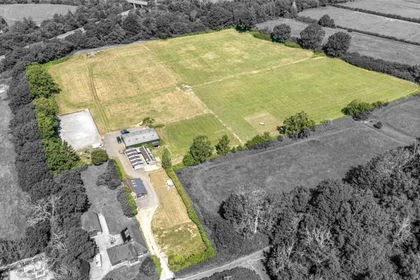
- Price
- Guide Price£1,100,000
- Size
- 10.85 acres
Reeds Lane, Southwater, Southwater, West Sussex RH13 England
Added on 09/09/2026Development Land
- Price
- Guide Price£700,000
- Size
- 4.46 acres
Burnt House Lane, Lower Beeding, Lower Beeding, West Sussex RH13 England
Added on 03/07/2026Agricultural Land