Gorsey Bank, Audlem Road, Woore, CW3
- Land size
- 8.7 acres
- Bedrooms
- 3
- Bathrooms
- 2
Description
A STRIKING DETACHED HOUSE WITH FANTASTIC EQUESTRIAN FACILITIES, TRIPLE GARAGE AND UTILITY SPACE AND STUNNING 360 DEGREE VIEWS OF THE SURROUNDING COUNTRYSIDE, ALL SET WITHIN 8.70 ACRES.
DESCRIPTION
Gorsey Bank, constructed of brick with rendered elevations under a tiled roof, stands back from the road approached over a sweeping gravel drive leading to a tarmacadam car parking and turning area. It is an impressive well presented home with a contemporary feel. The accommodation is laid out over two floors, with a real feeling of light and space aided by the amount of glazing and full length French and bi-folding doors which flood the house with natural light, aided by its 360 degree views over its land and countryside beyond.
Equestrian facilities are excellent with a concrete yard, ideal for small lorry/trailer parking, a super stable block with overhang including a foaling box (large corner stable) with rear window, power and water comprising four loose boxes and a tack room, muck heap, all weather menage with post and rail fencing and seven paddocks of pasture.
The above facilities coupled with the land make this a quite exceptional property for those with equestrian or indeed, small stock keeping interests.
LOCATION & AMENITIES
Gorsey Bank is situated in a picturesque part of the County close to the Shropshire/Staffordshire borders within easy reach of the serviced villages of Audlem (4 miles) and Woore (1 mile). Audlem caters for daily needs with local co-operative store, general store/newsagents, dry cleaners, butchers, flower shop, restaurant, cafe, three public houses and a medical centre. Woore village provides a range of local amenities, including post office/store, church, cricket and tennis clubs. The near-by market towns of Market Drayton, Nantwich and Whitchurch being 8, 10 and 12 miles respectively offering a more comprehensive range of services with high street banks, supermarkets and out of town retail parks. Despite its rural location Gorsey Bank is extremely accessible being approximately 10 miles from junction 16 on the M6 motorway permitting daily travel to Manchester, Liverpool, The Potteries and Birmingham. Travel to London is available by Crewe Railway Station which is 10 miles distance offering a 1 hour, 30 minutes service to Euston. International travel to Manchester and Birmingham Airports are 40 and 60 miles respectively.
DIRECTIONS
To reach the property from Audlem travel in an Easterly direction on the A525 towards Woore for about 3.5 miles and the property is located on the right hand side.
SUMMARY
Entrance Porch, Reception Hall, Living Room, Kitchen/Breakfast/Dining Room, Utility/Boot Room, Cloakroom, Landing, Master Bedroom with Ensuite Shower Room, Two Further Bedrooms, Bathroom, LPG Central Heating (underfloor heating to ground floor), uPVC Double Glazed Windows, Car Parking Space, Triple Garage Block with Home Office/Utility Store Above, Stable Block, All Weather Menage, Gardens with South West facing terrace, Orchard, Small Copse, Land, In all about 8.70 acres.
RECEPTION HALL
Composite entrance door, tiled floor, fine oak staircase to first floor.
LIVING ROOM
Open fireplace with oak surround, slate hearth and Clearview wood burning stove, oak flooring, two double glazed windows and French windows to terrace.
KITCHEN/BREAKFAST/DINING ROOM
An excellent range of kitchen furniture comprising floor standing cupboard and drawer units with worktops, white enamelled one and half bowl sink unit, wall to wall range of tall fitted cupboards, integrated dishwasher, refrigerator, microwave and wine cooler, integrated refrigerator/freezer, Lacanche Range style cooker with extractor hood above, tiled floor, inset ceiling lighting, vaulted ceiling in dining area, four double glazed windows and double glazed bi-folding doors to terrace, two Velux double glazed roof lights.
UTILITY/BOOT ROOM
Stainless steel single drainer sink unit, cupboard under, cupboard housing Ideal LPG gas central heating boiler, plumbing for washing machine, coat rack.
CLOAKROOM
White suite comprising low flush W/C and vanity unit with inset handbasin.
STAIRS FROM ENTRANCE HALL TO FIRST FLOOR LANDING
Inset ceiling lighting.
MASTER BEDROOM
Two double glazed windows and double glazed French windows to Juliet balcony, inset ceiling lighting.
SHOWER ROOM
Fully tiled walls, tiled floor, low flush W/C, vanity unit with granite basin, tiled shower cubicle with rain head shower and hand held shower.
BEDROOM NO. 2
Inset ceiling lighting.
BEDROOM NO. 3
Inset ceiling lighting.
BATHROOM
Fully tiled walls, tiled floor, white suite comprising panel bath with shower over, pedestal hand basin and low flush W/C, double glazed window, double glazed roof light.
OUTSIDE
Block and timber constructed GARAGE BLOCK comprising DOUBLE GARAGE 17'2" x 16'3" electrically operated rollover door, Ideal LPG boiler, inset ceiling lighting. SINGLE GARAGE 16'2" x 8'3" electrically operated rollover door, external staircase to HOMEOFFICE/UTILITY STORE 26'8" x 12'8", three double glazed windows, wood laminate floor, power points, shower room, white suite comprising low flush W/C, pedestal hand basin, tiled shower cubicle with shower, laminate floor, tiled walls. An excellent block and timber constructed well ventilated STABLE BLOCK with overhang, power and water comprising four loose boxes and a tack room, four measuring about 12'2" x 12'1" and one 18'3" x 12'1". Concrete hardstanding. All weather menage (40 metres x 25 metres). Muck heap, Sheep pens.
GARDEN
The garden comprises lawn, rose borders, a large South West facing flagged terrace and orchard.
LAND
The land, in permanent pasture, is divided into seven paddocks with post and rail and hedgerow boundaries. Some fine hedgerow trees give added appeal and interest. See enclosed plan, for identification purposes only.
SERVICES
Main water, electricity. Septic tank drainage.
TENURE
Freehold.
COUNCIL TAX
Band F.
VIEWINGS
By appointment with Baker, Wynne & Wilson.
Map Location
Property details
- Tenure
- Freehold
- Council Tax Band
- F
- Date Posted
- 2026-08-14
Market Value Analysis
Compared with 291 Homes with Land listings in West Midlands (5+ acres).
Utilities & Restrictions
Utilities
- Electricity
- Ask Agent
- Water
- Ask Agent
- Heating
- Ask Agent
- Broadband
- Ask Agent
- Sewerage
- Ask Agent
Rights & Restrictions
- Public Rights of Way
- Ask Agent
- Private Rights of Way
- Ask Agent
- Listed Property
- Ask Agent
- Restrictions
- Ask Agent
Listed status, conservation areas and planning constraints for this location are in the full report.
Property Features
- Accessibility
- Ask Agent
- Parking
- Parking Available
- Garden
- Garden
Beyond the particulars: planning activity, flood history, heritage and ground risks, checked for this exact spot.
Connectivity
Broadband
Fastest speed available at this postcode
1.8 Gbps
Gigabit full fibre · available to 90% of premises
Suitable for
- 4K streaming on every screen
- Full-time home working
- Online gaming & big downloads
Mobile signal
Outdoor predictions; indoor signal depends on building materials.
Ofcom Connected Nations postcode-level predictions. Speeds and signal are modelled, not measured, and vary between addresses and providers.
Signal is the easy part. Planning activity, flood history and protected designations here are in the full report.
Nearest Schools
Primary
- Woore Primary and Nursery School1 mileOfsted: Good
- Ages
- 2 to 11
- Pupils
- 81
- Type
- Academy converter
- Bridgemere CofE Primary School1.9 milesNo Ofsted rating
- Ages
- 3 to 11
- Pupils
- 94
- Type
- Voluntary aided school
- Faith
- Church of England
- Norton-in-Hales CofE Primary School2.9 milesNo Ofsted rating
- Ages
- 2 to 11
- Pupils
- 75
- Type
- Voluntary controlled school
- Faith
- Church of England
- St Mary's CofE Primary School3.4 milesNo Ofsted rating
- Ages
- 3 to 11
- Pupils
- 50
- Type
- Academy converter
- Faith
- Church of England
- Audlem St James' CofE Primary School3.5 milesOfsted: Good
- Ages
- 4 to 11
- Pupils
- 173
- Type
- Academy converter
- Faith
- Church of England
Secondary
- Madeley High School3.9 milesNo Ofsted rating
- Ages
- 11 to 16
- Pupils
- 779
- Type
- Academy converter
- The Grove School5.6 milesOfsted: Requires improvement
- Ages
- 11 to 18
- Pupils
- 856
- Type
- Academy converter
- Shavington Academy6.2 milesNo Ofsted rating
- Ages
- 11 to 16
- Pupils
- 934
- Type
- Academy converter
- Brine Leas School6.4 milesNo Ofsted rating
- Ages
- 11 to 18
- Pupils
- 1,417
- Type
- Academy converter
- Sir Thomas Boughey Academy6.5 milesOfsted report card · Jun 2026
- Ages
- 11 to 16
- Pupils
- 445
- Type
- Academy converter
Distances are straight-line from the advertised location. Source: the national school registers (DfE, Welsh Government, Scottish Government) and Ofsted.
Schools are just the start: sold prices nearby, planning activity and any flood history are in the full report.
Amenities
Supermarket
GP surgery
Pharmacy
Hospital
Straight-line distances from the advertised location. Sources: NHS records, Geolytix supermarket locations, OS Open Greenspace and the national trails registers.
The area stacks up? Now check the location itself: planning nearby, protected designations and past flooding.
Getting Around
Nearest station
Nearest bus stop
Typical drive times
Straight-line distances from the advertised location; drive times are typical free-flow times over OpenStreetMap road data, so allow more at peak. Public transport locations from DfT NaPTAN.
Easy to reach matters. So do planning activity, flood history and ground risks: all in the full report.
Flood Risk
From Environment Agency flood map open data, checked around the advertised map pin and allowing for the listed acreage where known. This summary comes from LandSale, the advertising platform, not from the listing agent, and is not part of the agent's particulars. Risk can vary across a single holding, so verify anything critical through your own searches before committing.
Rivers and the sea
Surface water
Mapped within the area searched, not at the advertised map pin itself.
These bandings are the summary. Where this location sits on the flood maps, plus planning activity, heritage and ground risks, is in the full report.
Important notice: Information, maps and tags on this page are drawn from the advertising agent's marketing materials or generated automatically. LandSale has not verified them. Relying on these details is at your own risk, always carry out independent checks before committing to a purchase.
LandSale full disclaimer
Marketing information only - not formal particulars. The details on this website are provided for general guidance and do not constitute an offer or contract. Neither LandSale nor the advertising estate/land agent accepts responsibility for any inaccuracy.
1. Source of information
- Listing content: Core description, asking price, tenure, measurements, photographs and planning history originate from the marketing materials of the advertising estate or land agent. LandSale does not author this content and cannot guarantee its accuracy.
- Automated tags & categorisation: Property type, land-use class, acreage bands and similar labels may be applied by machine-learning models. They are intended as a helpful guide only and may not reflect the property's legal status or permitted use.
- Third-party & enriched data layers: Maps, boundary outlines, planning designations, soil reports, broadband coverage and other environmental or location-based insights are licensed from external suppliers. Such data are supplied “as is", may be incomplete or out of date and are subject to change without notice.
2. Verification required
Prospective purchasers must verify critical matters, including but not limited to planning permission, title boundaries, public rights of way, environmental constraints, acreage, services, access and VAT status, through their own inspections, specialist surveys, legal advisers and the selling agent before relying on the information or entering into any contract.
3. No warranty or liability
LandSale gives no warranty, express or implied, as to the accuracy, completeness or fitness for any particular purpose of the information displayed. LandSale shall not be liable for any loss, damage, cost or expense arising directly or indirectly from any use of or reliance on such information, save where liability may not be excluded by law.
4. Updates & feedback
If you believe any detail on this listing is inaccurate, please let us know. We will investigate and, where appropriate, update the listing or notify the agent.
© LandSale | Version 1.3 - August 2026
Listing agent
Baker Wynne & Wilson, Nantwich
38 Pepper Street, Nantwich, Cheshire, CW5 5AB
View agent profileSimilar properties for sale
- Price
- Guide Price£800,000
- Size
- 8.6 acres
Added on 02/07/2026House with Land
- Price
- Guide Price£850,000
- Size
- 4.2 acres
Stapeley Farm, London Road, Nantwich, CW5, Stapeley and District, Cheshire East CW5 England
Added on 22/06/2026Development Land
- Price
- £975,000
- Size
- 5 acres
Knowl Wall, Beech, ST4, Swynnerton, Staffordshire ST4 England
Added on 17/04/2026House with Land
- Price
- Offers Over£1,250,000
- Size
- 9 acres
Windmill Cottage, Wrexham Road, Burland, Burland and Acton, Cheshire East CW5 England
Added on 29/01/2026House with Land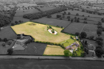
- Price
- Offers Over£1,250,000
- Size
- 9.1 acres
Wrexham Road, Burland, CW5, Burland and Acton, Cheshire East CW5 England
Added on 25/07/2026House with Land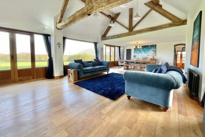
- Price
- Offers in Excess of£1,000,000
- Size
- 4 acres
Goldstone, Market Drayton, TF9, Cheswardine, Shropshire TF9 England
Added on 12/04/2026Barn Conversion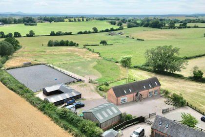
- Price
- £1,000,000
- Size
- 7 acres
Offley Marsh, Bishops Offley, ST21, Eccleshall, Staffordshire ST21 England
Added on 29/01/2026Equestrian property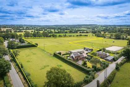
- Price
- Offers in Region of£815,000
- Size
- 8.18 acres
Stoke Park, Market Drayton, Stoke upon Tern, Shropshire TF9 England
Added on 28/06/2026Equestrian property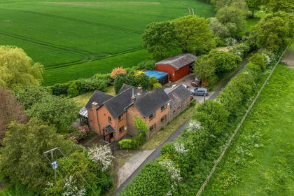
- Price
- Offers in Region of£795,000
- Size
- 6 acres
Six Acres, Hurst Lane, Stoke Park, Market Drayton, TF9, Stoke upon Tern, Shropshire TF9 England
Added on 04/06/2026House with Land
- Price
- Guide Price£950,000
- Size
- 4.5 acres
Added on 03/02/2026Equestrian property