Mill Lane, Stetchworth, CB8
- Land size
- 19 acres
- Bedrooms
- 4
- Bathrooms
- 2
Key Features
- 4-Bedroom Detached Barn-Style Home
- Approximately 19 Acres With Paddocks And Post-And-Rail Fencing
- Equestrian Facilities — 14 Stables, 2 Store Rooms And Foaling Stables
- Class Q Barn With Conversion Potential (STPP)
- Development Or Equestrian Opportunity
- Open-Plan Kitchen/Dining Room With Countryside Views
- Lounge With Feature Brick Fireplace
- Four Bedrooms, En-Suite To Principal And Family Bathroom
- Secure Gated Parking For Several Vehicles And Lorries
- Far-Reaching Views Towards Ely Cathedral On A Clear Day
Description
Watch Our Property Video Tour
See this home and its grounds in full. On phone or tablet, tap the Video Tours tab. On desktop, find the video within the photos.
Property Insight
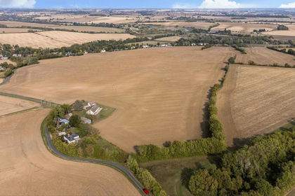
Set on the edge of Stetchworth with far-reaching countryside views — reaching to Ely Cathedral on a clear day — this modern barn-style home sits within grounds of approximately 19 acres, offering a rare combination of comfortable family living and substantial equestrian and development scope. The detached house is presented in good condition throughout, its black weatherboarded elevations over red brick echoing the agricultural character of its setting. Beyond the house lies an extensive range of facilities: fourteen stables, two store rooms, foaling stables and a large barn carrying Class Q conversion potential (STPP). Whether taken on as an established equestrian holding or explored for its wider potential, the property presents an unusual opportunity at this level.
At the heart of the ground floor is a generous open-plan kitchen and dining room, laid with terracotta tiles and fitted with cream shaker-style units, timber worktops and a Belfast sink, with an exposed timber post and large windows framing the paddocks beyond. The room offers ample space for a family table and everyday gathering, and flows naturally to a separate utility and a ground-floor cloakroom. Across the hall, the lounge is a comfortable, characterful space centred on a feature brick fireplace with a timber mantel, again finished with terracotta flooring and dual windows that draw in light and views. The layout balances sociable open-plan living with a quieter room to retreat to.
Upstairs, four bedrooms are arranged off the landing, the principal enjoying an en-suite alongside a family bathroom finished in natural stone-effect tiling, with several rooms taking in open field and paddock views. Outside, the grounds extend to approximately nineteen acres of paddocks bordered by post-and-rail fencing, with a paved terrace to the rear of the house and secure gated parking for several vehicles and lorries. The stable ranges and barn sit within the plot, offering scope for equestrian use or, subject to consent, further development. A genuinely versatile holding in a well-regarded village setting, rewarding a closer look in person.
At a Glance
Type: Detached barn-style house, freehold
Size: House approximately 1,490 sq ft; grounds approximately 19 acres, with extensive equestrian outbuildings (approximately 6,083 sq ft)
Bedrooms: 4
Bathrooms: 2 — family bathroom plus en-suite to principal
Reception Rooms: Lounge with feature brick fireplace, plus open-plan kitchen/dining room
Kitchen: Cream shaker-style units, timber worktops, Belfast sink, terracotta tiled floor
Outside: Approximately 19 acres of paddocks with post-and-rail fencing, paved rear terrace
Parking: Secure gated parking for several vehicles and lorries
Equestrian: 14 stables, 2 store rooms, foaling stables and a large barn
Potential: Class Q barn with conversion potential (STPP); wider equestrian or development scope
Cloakroom: Ground floor
Station: Dullingham and Newmarket, with services to Cambridge, London and Ipswich
Agents Notes
Tenure: Freehold
Access: A neighbouring private development holds a right of access across part of the land. Protective covenants are in place benefiting this property, restricting noise and disturbance. The development's entrance is to be professionally landscaped and made good by the developers.
Neighbouring Development Image: One of the marketing images is a computer-generated image (CGI) showing how the neighbouring private development is anticipated to look once complete. It is indicative only, is not a photograph of the site in its current condition, and does not form part of the property offered for sale. Final appearance may differ.
Note: Prospective buyers should verify the access arrangement, covenants and boundaries with their solicitor. These details should also be entered in the portal Material Information fields.
Walk Through This Home — Virtually
Take a 360° tour from your phone or laptop.
Anti-Money Laundering (AML) Checks:
In line with the Money Laundering Regulations 2017, we are legally required to carry out identity and AML checks on all buyers. A fee of £25 (inc. VAT) per buyer is payable once an offer has been formally accepted. This fee is mandatory and forms part of our regulatory compliance obligations.
Location – Stetchworth
Stetchworth is a sought-after village in East Cambridgeshire, positioned approximately 3 miles south of the historic racing town of Newmarket and around 15 miles east of Cambridge, close to the neighbouring villages of Dullingham and Woodditton. Surrounded by open countryside on the edge of the Newmarket area, it offers a genuinely rural setting while remaining well connected to town and city.
At the heart of the village is St Peter's Church, hosting regular services and community events, alongside a village primary school, a village pub and a village hall that serves as a focus for local clubs and gatherings. Newmarket provides the fuller day-to-day offering — supermarkets, independent shops, restaurants, healthcare and both state and independent schooling — while the nearby Devil's Dyke and surrounding bridleways and footpaths give excellent walking, cycling and riding on the doorstep.
Transport links are strong: the A11 and A14 provide direct road access towards Cambridge, Bury St Edmunds and the M11, while railway stations at Dullingham and Newmarket offer services to Cambridge, London and Ipswich.
Map Location
Property details
- Tenure
- Freehold
- Council Tax Band
- Ask Agent
- Date Posted
- 2026-08-13
Market Value Analysis
Compared with 71 Homes with Land listings in East Anglia (10+ acres).
Utilities & Restrictions
Utilities
- Electricity
- Mains
- Water
- Mains
- Heating
- Oil Heating
- Broadband
- Fibre (FTTC)
- Sewerage
- Mains
Rights & Restrictions
- Public Rights of Way
- Ask Agent
- Private Rights of Way
- Ask Agent
- Listed Property
- Ask Agent
- Restrictions
- Ask Agent
Listed status, conservation areas and planning constraints for this location are in the full report.
Property Features
- Accessibility
- Ask Agent
- Parking
- Parking Available
- Garden
- Garden
Beyond the particulars: planning activity, flood history, heritage and ground risks, checked for this exact spot.
Connectivity
Broadband
Fastest speed available at this postcode
1.8 Gbps
Gigabit full fibre · available to 68% of premises
Suitable for
- 4K streaming on every screen
- Full-time home working
- Online gaming & big downloads
Mobile signal
Predicted 4G and 5G signal; indoor signal depends on building materials.
Ofcom Connected Nations postcode-level predictions. Speeds and signal are modelled, not measured, and vary between addresses and providers.
Signal is the easy part. Planning activity, flood history and protected designations here are in the full report.
Nearest Schools
Primary
- Kettlefields Primary School259 metresOfsted: Good
- Ages
- 4 to 11
- Pupils
- 145
- Type
- Community school
- Burrough Green CofE Primary Academy1.7 milesOfsted: Requires improvement
- Ages
- 4 to 11
- Pupils
- 51
- Type
- Academy sponsor led
- Faith
- Church of England
- Ditton Lodge Primary School2.6 milesOfsted report card · Mar 2026
- Ages
- 4 to 11
- Pupils
- 204
- Type
- Academy converter
- Houldsworth Valley Primary Academy3.1 milesOfsted: Good
- Ages
- 4 to 11
- Pupils
- 332
- Type
- Academy sponsor led
- All Saints Church of England Primary School, Newmarket3.1 milesOfsted: Good
- Ages
- 4 to 11
- Pupils
- 177
- Type
- Academy sponsor led
- Faith
- Church of England
Secondary
- Newmarket Academy3.5 milesOfsted: Good
- Ages
- 11 to 16
- Pupils
- 797
- Type
- Academy sponsor led
- Bottisham Village College6.2 milesOfsted: Requires improvement
- Ages
- 11 to 16
- Pupils
- 1,396
- Type
- Academy converter
- Samuel Ward Academy7.9 milesOfsted: Good
- Ages
- 11 to 18
- Pupils
- 1,076
- Type
- Academy converter
- Castle Manor Academy8 milesNo Ofsted rating
- Ages
- 11 to 16
- Pupils
- 760
- Type
- Academy converter
- Linton Village College8.7 milesOfsted: Good
- Ages
- 11 to 16
- Pupils
- 766
- Type
- Academy converter
Distances are straight-line from the advertised location. Source: the national school registers (DfE, Welsh Government, Scottish Government) and Ofsted.
Schools are just the start: sold prices nearby, planning activity and any flood history are in the full report.
Amenities
Supermarket
GP surgery
Pharmacy
Hospital
Green space
Straight-line distances from the advertised location. Sources: NHS records, Geolytix supermarket locations, OS Open Greenspace and the national trails registers.
The area stacks up? Now check the location itself: planning nearby, protected designations and past flooding.
Getting Around
Nearest station
Nearest bus stop
Typical drive times
Straight-line distances from the advertised location; drive times are typical free-flow times over OpenStreetMap road data, so allow more at peak. Public transport locations from DfT NaPTAN.
Easy to reach matters. So do planning activity, flood history and ground risks: all in the full report.
Flood Risk
Environment Agency open data, checked around the advertised map pin for the listed acreage. Long-term risk counts flood defences; the planning map's flood zones do not. Provided by LandSale, not the listing agent, and not part of the agent's particulars. Risk varies across a holding, so verify before committing.
Rivers and the sea
Planning map: Flood Zone 1.
Surface water
Not at the pin: mapped about 60 metres away.
These bandings are the summary. Where this location sits on the flood maps, plus planning activity, heritage and ground risks, is in the full report.
Important notice: Information, maps and tags on this page are drawn from the advertising agent's marketing materials or generated automatically. LandSale has not verified them. Relying on these details is at your own risk, always carry out independent checks before committing to a purchase.
LandSale full disclaimer
Marketing information only - not formal particulars. The details on this website are provided for general guidance and do not constitute an offer or contract. Neither LandSale nor the advertising estate/land agent accepts responsibility for any inaccuracy.
1. Source of information
- Listing content: Core description, asking price, tenure, measurements, photographs and planning history originate from the marketing materials of the advertising estate or land agent. LandSale does not author this content and cannot guarantee its accuracy.
- Automated tags & categorisation: Property type, land-use class, acreage bands and similar labels may be applied by machine-learning models. They are intended as a helpful guide only and may not reflect the property's legal status or permitted use.
- Third-party & enriched data layers: Maps, boundary outlines, planning designations, soil reports, broadband coverage and other environmental or location-based insights are licensed from external suppliers. Such data are supplied “as is", may be incomplete or out of date and are subject to change without notice.
2. Verification required
Prospective purchasers must verify critical matters, including but not limited to planning permission, title boundaries, public rights of way, environmental constraints, acreage, services, access and VAT status, through their own inspections, specialist surveys, legal advisers and the selling agent before relying on the information or entering into any contract.
3. No warranty or liability
LandSale gives no warranty, express or implied, as to the accuracy, completeness or fitness for any particular purpose of the information displayed. LandSale shall not be liable for any loss, damage, cost or expense arising directly or indirectly from any use of or reliance on such information, save where liability may not be excluded by law.
4. Updates & feedback
If you believe any detail on this listing is inaccurate, please let us know. We will investigate and, where appropriate, update the listing or notify the agent.
© LandSale | Version 1.3 - August 2026
Listing agent
Ensum Brown, Newmarket
Cleveland House, Old Station Road, Newmarket, CB8 8QE
Contact Ensum Brown, Newmarket
Cleveland House, Old Station Road, Newmarket, CB8 8QE
View agent profileSimilar properties for sale
- Price
- Guide Price£1,250,000
- Size
- 85.64 acres
Homefield Farm, Sturmer, Haverhill, Essex, Sturmer, Essex CB9 England
Added on 01/10/2026Farm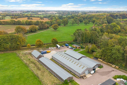
- Price
- Guide Price£1,250,000
- Size
- 16.7 acres
Added on 16/04/2026Barn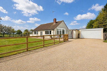
- Price
- £1,595,000
- Size
- 18 acres
Mill Road, Great Bardfield, Braintree, Finchingfield, Essex CM7 England
Added on 10/06/2026Redevelopment Land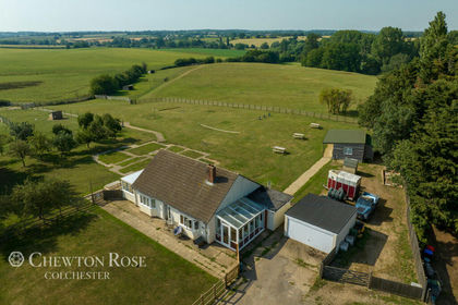
- Price
- Offers in Excess of£1,500,000
- Size
- 18 acres
Mill Road, Great Bardfield, Great Bardfield, Essex CM7 England
Added on 20/07/2026House with Land
- Price
- £1,350,000
- Size
- 16 acres
Pymoor Lane, Pymoor, CB6, Downham, Cambridgeshire CB6 England
Added on 24/06/2026Equestrian property
- Price
- Offers in Excess of£1,350,000
- Size
- 10 acres
Horsley Hale, Littleport, CB6, Littleport, Cambridgeshire CB6 England
Added on 19/05/2026House with Land
- Price
- Guide Price£1,850,000
- Size
- 10 acres
Added on 09/07/2026Country Estate
- Price
- Offers in Excess of£1,750,000
- Size
- 10 acres
Coney Weston Road, Barningham., Barningham, Suffolk IP31 England
Added on 02/10/2026House with Land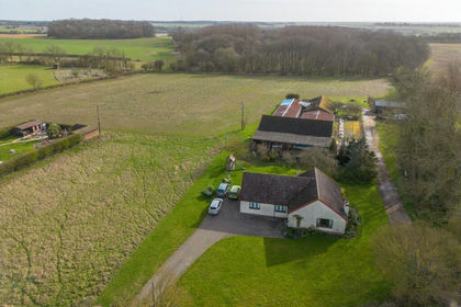
- Price
- £1,800,000
- Size
- 33.11 acres
Added on 01/04/2026Development Land
- Price
- Guide Price£1,650,000
- Size
- 10 acres
Added on 03/07/2026Estate