Ditton Priors, Bridgnorth, Shropshire
- Land size
- 50 acres
Description
Upon instructions from Mrs C A Lewis
FOR SALE BY INFORMAL TENDER
APPROXIMATELY 50 ACRES (20.29 HECTARES) OF PASTURELAND AS A WHOLE OR IN TWO LOTS SITUATED AT RUTHALL FARM, DITTON PRIORS, BRIDGNORTH, SHROPSHIRE WV16 6TN.
FREEHOLD WITH VACANT POSSESSION ON COMPLETION.
TENDERS CLOSE FRIDAY 28TH AUGUST 2026 AT 5.00 P.M.
GENERAL REMARKS AND STIPULATIONS
GROWING TIMBER
All timber is included in the sale.
SPORTING RIGHTS
All sporting rights are in hand and will be sold with the land.
MISREPRESENTATION ACT
McCartneys for themselves and the vendors of the property, whose Agents they are, give notice that these particulars, although believed correct, do not constitute any part of any offer or contract, and that all the statements contained therein as to the property are made without responsibility and are not to be relied upon as statements or representations of fact, and that they do not give any representation or warranty in relation to this property. The intending purchaser must satisfy himself by inspection or otherwise as to the correctness of each of the statements contained in the particulars.
PLANS, AREAS AND SCHEDULES
These are based on the Ordnance Survey and are for reference only. The purchaser shall be deemed to have satisfied himself as to the description of the property, and any error or misstatement shall not annul the sale or entitle any party to compensation in respect thereof.
WAYLEAVES, EASEMENTS AND RIGHTS OF WAY
The property is sold subject to and with the benefit of all easements, quasi-easements, wayleaves and rights of way, declared and undeclared. Please note there will be a reservation in favour of lot 2 over lot 1 for the granting of an easement to lay a water pipe from the main in Ashfield Road.
TENURE AND POSSESSION TENURE AND POSSESSION
The property is sold freehold with vacant possession on completion.
VIEWING
At any reasonable time.
METHOD OF SALE
By informal tender.
INGOING VALUATION
There will be no ingoing valuation.
RESERVATION OF RIGHTS
In the event that following tenders there are a number which have little difference between them the vendor reserves the right to put the property up for sale by private auction with invitations being delivered to the highest tenderers to attend. The vendors would rather carry out such a process than enter a Dutch auction situation.
HIGHER LEVEL STEWARDSHIP SCHEME
A higher level stewardship scheme is in existence for the whole of the land which produces an annual payment of approximately £5,576.70. The end date for the agreement is 31st March 2028. The vendor reserves the right to the payment for the 2026 year on a pro-rata basis, i.e. all payment monies before completion of sale. Any payment monies received after this date and before 31st March 2028 will be paid to the new owner. The new owner will be required to enter into an indemnity for any breaches of the existing stewardship scheme between completion and the ending of the agreement on 31/03/28. The purchaser will be required to take on the existing higher level stewardship scheme for the remainder of its length.
SIGNING OF CONTRACT
The successful purchaser will be required to sign a contract within four weeks of acceptance of their tender as far as is practical.
UPPLIFT CLAUSE FOR LOT 2
Because of the proximity of lot 2 to recent developments in the village of Ditton Priors, there will be an uplift clause for any non-agricultural development – excluding horses – for a period of twenty years with an uplift clause of 30% of any increase in value after allowing for the costs of obtaining planning permission and any community infrastructure levy. Such uplift to be triggered by the granting of planning permission.
SOLICITORS
Lanyon Bowdler, Grosvenor House, Hollingswood Road, Central Park, Telford TF2 9TW. Tel : (Ref. Mrs Susan Grazier) Susan.
PARTICULARS OF SALE
Lot 1
A block of approximately 28.6 acres (11.59 hectares) of pastureland with access from Ashfield Road, Ditton Priors, designated lot 1 on the attached plan and coloured red.
Description
This block of pastureland has excellent access and is in good heart. It is well hedged and fenced and is served by a natural water supply which has never failed. Having said that, there is a water main running along the edge of the field which with appropriate permission can be tapped into. There is a good face on all of the grazing and the soil is of a clay nature. The land is more particularly described in the following schedule:
SCHEDULE
RPA No Description Area Ha / Acres 0432 Pasture 4.37 / 10.79 9544 Pasture 1.09 / 2.69 1546 Pasture 2.06 / 5.09 0457 (divided into 3 separate parcels) Pasture 4.07 / 10.05 Total 11.59 / 28.62 GUIDE PRICE £8,000 PER ACRE
Lot 2
A block of approximately 21.5 acres (8.7 hectares) of pastureland with access from Ruthall Lane, Ditton Priors, designated lot 2 on the attached plan and coloured blue.
Description
This lot comprises a useful block of level pastureland which would also be suited to arable production. It has direct public highway access. Natural water supply which has never failed – reservation of an easement across lot 1 if the new purchaser requires to install mains water. The land is well hedged and fenced and again is in good heart and is more particularly described in the following schedule:
Schedule
RPA No Description Area Ha / Acres 2370 Pasture 5.83 / 14.4 0480 Pasture 2.87 / 7.1(est) Total 8.7 / 21.5 GUIDE PRICE £10,000 PER ACRE
TENDER DOCUMENT
Attached to brochure
CONDITIONS OF TENDER
1. All tenders must be received at the agents’ offices at Ludlow Livestock Market, The Ox Pasture, Overton Road, Ludlow, SY8 4BH by 5.00pm on Friday 28th August 2026. 2. The vendor is not obliged to accept the highest tender or indeed any of the tenders. 3. A contract must be signed by Friday 2nd October 2026 with completion being when vacant possession is given at the end of the existing grass keep licence for lot 1 which is the end of October 2026. 4. In the event of a number of tenders being in a close proximity the vendor reserves the right to hold a private auction with invitations for bidders only. 5. Successful purchaser will be required to provide a photographic form of ID such as Driver’s licence or passport and a utility bill or bank statement confirming their home address. This is to meet anti money laundering regulations. 6. The vendor will consider offers for parts of the property, for example one of the fields. If you want to make an offer for part of (truncated)
Note to Buyers
AML checks will be undertaken for successful buyers and there is a fee of £18.00 including vat per person payable.
Map Location
Property details
- Tenure
- Freehold
- Council Tax Band
- TBC
- Date Posted
- 2026-08-08
Market Value Analysis
Compared with 35 Farmland & Pasture listings in West Midlands (50+ acres).
Utilities & Restrictions
Utilities
- Electricity
- Ask Agent
- Water
- Ask Agent
- Heating
- Ask Agent
- Broadband
- Ask Agent
- Sewerage
- Ask Agent
Rights & Restrictions
- Public Rights of Way
- Ask Agent
- Private Rights of Way
- Ask Agent
- Listed Property
- Ask Agent
- Restrictions
- Ask Agent
Listed status, conservation areas and planning constraints for this location are in the full report.
Property Features
- Accessibility
- Ask Agent
- Parking
- Ask Agent
- Garden
- Ask Agent
Beyond the particulars: planning activity, flood history, heritage and ground risks, checked for this exact spot.
Connectivity
Broadband
Fastest speed available at this postcode
80 Mbps
Superfast · available to 25% of premises
Suitable for
- HD streaming
- Video calls
- Web & social
Fixed wireless access may also be an option here.
Mobile signal
Predicted 4G and 5G signal; indoor signal depends on building materials.
Ofcom Connected Nations postcode-level predictions. Speeds and signal are modelled, not measured, and vary between addresses and providers.
Signal is the easy part. Planning activity, flood history and protected designations here are in the full report.
Nearest Schools
Primary
- Brown Clee CofE Primary School0.8 milesNo Ofsted rating
- Ages
- 4 to 11
- Pupils
- 101
- Type
- Voluntary controlled school
- Faith
- Church of England
- Brockton CofE Primary School2.9 milesOfsted report card · Mar 2026
- Ages
- 2 to 11
- Pupils
- 51
- Type
- Voluntary controlled school
- Faith
- Church of England
- Morville CofE (Controlled) Primary School5.2 milesOfsted: Good
- Ages
- 5 to 11
- Pupils
- 59
- Type
- Academy sponsor led
- Faith
- Church of England
- Rushbury CofE Primary School5.4 milesOfsted: Good
- Ages
- 4 to 11
- Pupils
- 64
- Type
- Voluntary controlled school
- Faith
- Church of England
- Church Preen Primary School5.5 milesOfsted: Good
- Ages
- 4 to 11
- Pupils
- 41
- Type
- Community school
Secondary
- William Brookes School6.9 milesOfsted: Requires improvement
- Ages
- 11 to 16
- Pupils
- 748
- Type
- Academy converter
- Oldbury Wells School7.2 milesNo Ofsted rating
- Ages
- 11 to 16
- Pupils
- 740
- Type
- Academy converter
- Bridgnorth Endowed School7.6 milesOfsted: Good
- Ages
- 11 to 16
- Pupils
- 601
- Type
- Academy converter
- Church Stretton School9.4 milesNo Ofsted rating
- Ages
- 11 to 16
- Pupils
- 539
- Type
- Academy converter
- The Lacon Childe School9.8 milesOfsted: Requires improvement
- Ages
- 11 to 16
- Pupils
- 563
- Type
- Academy converter
Distances are straight-line from the advertised location. Source: the national school registers (DfE, Welsh Government, Scottish Government) and Ofsted.
Schools are just the start: sold prices nearby, planning activity and any flood history are in the full report.
Amenities
Supermarket
GP surgery
Pharmacy
Hospital
Green space
Straight-line distances from the advertised location. Sources: NHS records, Geolytix supermarket locations, OS Open Greenspace and the national trails registers.
The area stacks up? Now check the location itself: planning nearby, protected designations and past flooding.
Getting Around
Nearest station
Nearest bus stop
Typical drive times
Straight-line distances from the advertised location; drive times are typical free-flow times over OpenStreetMap road data, so allow more at peak. Public transport locations from DfT NaPTAN.
Easy to reach matters. So do planning activity, flood history and ground risks: all in the full report.
Flood Risk
Environment Agency open data, checked around the advertised map pin for the listed acreage. Long-term risk counts flood defences; the planning map's flood zones do not. Provided by LandSale, not the listing agent, and not part of the agent's particulars. Risk varies across a holding, so verify before committing.
Rivers and the sea
Planning map: Flood Zone 1.
Surface water
Not at the pin: mapped about 80 metres away.
These bandings are the summary. Where this location sits on the flood maps, plus planning activity, heritage and ground risks, is in the full report.
Important notice: Information, maps and tags on this page are drawn from the advertising agent's marketing materials or generated automatically. LandSale has not verified them. Relying on these details is at your own risk, always carry out independent checks before committing to a purchase.
LandSale full disclaimer
Marketing information only - not formal particulars. The details on this website are provided for general guidance and do not constitute an offer or contract. Neither LandSale nor the advertising estate/land agent accepts responsibility for any inaccuracy.
1. Source of information
- Listing content: Core description, asking price, tenure, measurements, photographs and planning history originate from the marketing materials of the advertising estate or land agent. LandSale does not author this content and cannot guarantee its accuracy.
- Automated tags & categorisation: Property type, land-use class, acreage bands and similar labels may be applied by machine-learning models. They are intended as a helpful guide only and may not reflect the property's legal status or permitted use.
- Third-party & enriched data layers: Maps, boundary outlines, planning designations, soil reports, broadband coverage and other environmental or location-based insights are licensed from external suppliers. Such data are supplied “as is", may be incomplete or out of date and are subject to change without notice.
2. Verification required
Prospective purchasers must verify critical matters, including but not limited to planning permission, title boundaries, public rights of way, environmental constraints, acreage, services, access and VAT status, through their own inspections, specialist surveys, legal advisers and the selling agent before relying on the information or entering into any contract.
3. No warranty or liability
LandSale gives no warranty, express or implied, as to the accuracy, completeness or fitness for any particular purpose of the information displayed. LandSale shall not be liable for any loss, damage, cost or expense arising directly or indirectly from any use of or reliance on such information, save where liability may not be excluded by law.
4. Updates & feedback
If you believe any detail on this listing is inaccurate, please let us know. We will investigate and, where appropriate, update the listing or notify the agent.
© LandSale | Version 1.3 - August 2026
Listing agent
McCartneys LLP, Ox Pasture Rural
The Ox Pasture Overton Road, Ludlow, SY8 4AA
Contact McCartneys LLP, Ox Pasture Rural
The Ox Pasture Overton Road, Ludlow, SY8 4AA
View agent profileSimilar properties for sale
- Price
- Offers in Excess of£460,800
- Size
- 38.4 acres
Added on 28/08/2026Arable Land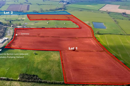
- Price
- Guide Price£400,000
- Size
- 42.7 acres
Ebstree Road, Trysull, Wolverhampton, WV5, Trysull and Seisdon, Staffordshire WV5 England
Added on 04/04/2026Arable Land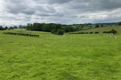
- Price
- £500,000
- Size
- 44.06 acres
Tedstone Wafre, Bromyard, Edvin Loach and Saltmarshe, Herefordshire, County of HR7 England
Added on 29/01/2026Farmland
- Price
- Guide Price£395,000
- Size
- 33.03 acres
33.03 Acres Arable Land, Hatfield, Worcester, Norton Juxta Kempsey, Worcestershire WR5 England
Added on 17/08/2026Arable Land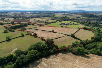
- Price
- Guide Price£500,000
- Size
- 28.55 acres
Inkberrow, Worcestershire, Inkberrow, Worcestershire WR7 England
Added on 24/09/2026Agricultural Land
- Price
- Offers Over£300,000
- Size
- 33.61 acres
Land Formerly Part of Neuaddllwyd, Llandinam, Powys, SY17, Llandinam, Powys SY17 Wales
Added on 29/01/2026Grazing Land