Clopton Nr Woodbridge
- Land size
- 5.05 acres
Description
Introduction
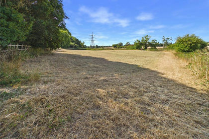
The land at Shop Road extends to approximately 5.05 acres (2.04 hectares) and comprises a well maintained area of grassland. The property enjoys a wonderful rural location along a no through road, on the outskirts of Clopton.
Method of Sale
We are instructed to offer the land by private treaty inviting offers for the whole with the intention of achieving exchange of contracts as soon as possible with completion four weeks thereafter.
It is expected that the purchaser will be required to sign an ‘Exclusivity Agreement’ with a 5% ‘Exclusivity Fee’ being paid to and held by the Vendor’s solicitor. A draft ‘Exclusivity Agreement’ is available from the Agent.
Vendor’s Solicitor
Birketts Solicitors, Providence House, 141-145 Princes Street, Ipswich, IP1 1QJ Tel: . Contact: Iona Chisholm Email: iona-
Location
Shop Road is located on the outskirts of village of the popular village of Clopton. Whilst in a very pleasant rural location, the land is well placed for access to Ipswich (nine miles), Woodbridge (seven miles) and Framlingham (eight miles). The neighbouring village of Otley has a well regarded Post Office/village shop, a doctors surgery, primary school, village hall and excellent pub. Trains to London’s Liverpool Street Station can be found at Ipswich. The coast, with popular destinations such as Aldeburgh, Thorpeness and Southwold, is just 18 miles.
Description
The property occupies an attractive rural position along Shop Road in Clopton, Suffolk, with convenient access to the surrounding countryside and nearby amenities. It comprises a well maintained equestrian facility extending in total to approximately 13.18 acres (5.33 hectares), arranged across two parcels of grassland, creating a balanced and practical layout for equine management.
The land is offered for sale in two lots and is shown for identification purposes on the enclosed plan.
Lot 2 - Grassland - Extending to 5.05 acres (2.04 ha).
Lying to the south of Lot 1 lies an area of grassland which is shown hatched blue on the enclosed plan. The parcel benefits from a gated entrance directly off Shop Road. The land is flat in topography and the boundaries are well defined by livestock fencing and a mixture of mature trees and hedgerows. A drainage ditch runs along the northern boundary of Lot 2 providing water drainage in wetter months. The land is mostly rectangular in shape and adjoins a residential property on the western boundary.
The land was previously within an arable rotation and is shown as Grade 3 on the Agricultural Land Classification map for England, the soil type is described as “Lime-rich loamy and clayey soils with impeded drainage” on the NATMAP Soilscapes Plan for Scotland and England. For the past 4 years the land has been used as grazing for equine purposes.
The land is being sold freehold with vacant possession upon completion.
Viewings
At any reasonable time, with particulars in hand, by arrangement with the Agents first.
Rights of Way, Wayleaves, Easements Etc.
The property is sold subject to and with the benefit of all rights of way, wayleaves and easements that may affect the land.
Timber, Sporting and Minerals
All sporting rights, standing timber and mineral rights (except reserved by Statute or to the Crown) are included in the sale of the freehold.
Environmental Stewardship Scheme
The land is not included within an Environment Stewardship Scheme.
Boundaries
All boundaries shall be as previously and the Vendor shall not be required to define the same. These are shown for identification purposes only outlined red on the attached plan. Purchasers should satisfy themselves with regard to these as no error, omission or misstatements will allow the purchaser to rescind the contract nor entitle either party to compensation thereof.
The land is registered with the Land Registry under Title Number SK427640.
Town and Country Planning
The property is sold subject to any development plans, tree preservation orders, ancient monument orders and Town and Country schedules or other similar matters that may be or come into force.
Outgoings & VAT
The land is sold subject to any drainage rates and other outgoings that may be relevant. Should any sale of the land, or any right attached to it, become a chargeable supplier for the purpose of VAT, such VAT shall be payable by the purchaser in addition to the contract price.
Tenure and Possession
The land is being sold freehold with vacant possession upon completion.
Services
The land benefits from a mains water connection, serving the entire property. No other services are connected.
NOTES
1. Every care has been taken with the preparation of these particulars, but complete accuracy cannot be guaranteed. If there is any point, which is of particular importance to you, please obtain professional confirmation. Alternatively, we will be pleased to check the information for you. These Particulars do not constitute a contract or part of a contract. All measurements quoted are approximate. The Fixtures, Fittings & Appliances have not been tested and therefore no guarantee can be given that they are in working order. Photographs are reproduced for general information and it cannot be inferred that any item shown is included. No guarantee can be given that any planning permission or listed building consent or building regulations have been applied for or approved. The agents have not been made aware of any covenants or restrictions that may impact the property, unless stated otherwise. Any site plans used in the particulars are indicative only and buyers should rely on the Land Registry/transfer plan.
2. The Money Laundering, Terrorist Financing and Transfer of Funds (Information on the Payer) Regulations 2017 require all Estate Agents to obtain sellers’ and buyers’ identity.
July 2026
Map Location
Property details
- Tenure
- Freehold
- Council Tax Band
- Ask Agent
- Date Posted
- 2026-07-25
Market Value Analysis
Compared with 38 Bare & Undeveloped Land listings in East Anglia (5+ acres).
Utilities & Restrictions
Utilities
- Electricity
- Ask Agent
- Water
- Ask Agent
- Heating
- Ask Agent
- Broadband
- Ask Agent
- Sewerage
- Ask Agent
Rights & Restrictions
- Public Rights of Way
- Ask Agent
- Private Rights of Way
- Ask Agent
- Listed Property
- Ask Agent
- Restrictions
- Ask Agent
Listed status, conservation areas and planning constraints for this location are in the full report.
Property Features
- Accessibility
- Ask Agent
- Parking
- Ask Agent
- Garden
- Ask Agent
Beyond the particulars: planning activity, flood history, heritage and ground risks, checked for this exact spot.
Connectivity
Broadband
Fastest speed available at this postcode
1.8 Gbps
Gigabit full fibre
Suitable for
- 4K streaming on every screen
- Full-time home working
- Online gaming & big downloads
Fixed wireless access may also be an option here.
Mobile signal
Outdoor predictions; indoor signal depends on building materials.
Ofcom Connected Nations postcode-level predictions. Speeds and signal are modelled, not measured, and vary between addresses and providers.
Signal is the easy part. Planning activity, flood history and protected designations here are in the full report.
Nearest Schools
Primary
- Otley Primary School1.3 milesOfsted: Good *
- Ages
- 4 to 11
- Pupils
- 51
- Type
- Community school
- Charsfield Church of England Primary School2.1 milesNo Ofsted rating
- Ages
- 4 to 11
- Pupils
- 34
- Type
- Academy converter
- Faith
- Church of England
- Grundisburgh Primary School2.6 milesNo Ofsted rating
- Ages
- 5 to 11
- Pupils
- 169
- Type
- Community school
- Witnesham Primary School2.9 milesOfsted: Good
- Ages
- 4 to 11
- Pupils
- 90
- Type
- Community school
- Helmingham Primary School and Nursery3.3 milesOfsted report card · Apr 2026
- Ages
- 2 to 11
- Pupils
- 30
- Type
- Academy sponsor led
Secondary
- Farlingaye High School3.9 milesOfsted report card · May 2026
- Ages
- 11 to 18
- Pupils
- 1,861
- Type
- Academy converter
- Kesgrave High School5.5 milesOfsted: Good
- Ages
- 11 to 18
- Pupils
- 1,875
- Type
- Academy converter
- Northgate High School6 milesOfsted: Good *
- Ages
- 11 to 18
- Pupils
- 1,750
- Type
- Community school
- St Alban's Catholic High School6.2 milesOfsted: Good
- Ages
- 11 to 18
- Pupils
- 967
- Type
- Academy converter
- Faith
- Roman Catholic
- Debenham High School6.3 milesOfsted: Good
- Ages
- 11 to 16
- Pupils
- 714
- Type
- Academy converter
- Faith
- Church of England
* Latest graded judgement covers quality of education only; no overall grade was issued under the 2024-25 inspection framework.
Distances are straight-line from the advertised location. Source: the national school registers (DfE, Welsh Government, Scottish Government) and Ofsted.
Schools are just the start: sold prices nearby, planning activity and any flood history are in the full report.
Amenities
Supermarket
GP surgery
Pharmacy
Hospital
Green space
Straight-line distances from the advertised location. Sources: NHS records, Geolytix supermarket locations, OS Open Greenspace and the national trails registers.
The area stacks up? Now check the location itself: planning nearby, protected designations and past flooding.
Getting Around
Nearest station
Nearest bus stop
Typical drive times
Straight-line distances from the advertised location; drive times are typical free-flow times over OpenStreetMap road data, so allow more at peak. Public transport locations from DfT NaPTAN.
Easy to reach matters. So do planning activity, flood history and ground risks: all in the full report.
Flood Risk
From Environment Agency flood map open data, checked around the advertised map pin and allowing for the listed acreage where known. This summary comes from LandSale, the advertising platform, not from the listing agent, and is not part of the agent's particulars. Risk can vary across a single holding, so verify anything critical through your own searches before committing.
Rivers and the sea
Surface water
Mapped within the area searched, not at the advertised map pin itself.
The detail behind these bandings
The full report pinpoints where this location sits on the flood maps, and runs the deeper checks that usually only surface after an offer.
- Exact flood zones & annual chances (included in the full report)
- Any recorded past flooding (included in the full report)
- Planning activity nearby (included in the full report)
- Heritage & conservation (included in the full report)
- Protected nature designations (included in the full report)
- Ground risks (included in the full report)
- Sold prices nearby (included in the full report)
£14.99 · one-off purchase
By LandSale, the platform. Not provided by the listing agent. Ready in about a minute.
Important notice: Information, maps and tags on this page are drawn from the advertising agent's marketing materials or generated automatically. LandSale has not verified them. Relying on these details is at your own risk, always carry out independent checks before committing to a purchase.
LandSale full disclaimer
Marketing information only - not formal particulars. The details on this website are provided for general guidance and do not constitute an offer or contract. Neither LandSale nor the advertising estate/land agent accepts responsibility for any inaccuracy.
1. Source of information
- Listing content: Core description, asking price, tenure, measurements, photographs and planning history originate from the marketing materials of the advertising estate or land agent. LandSale does not author this content and cannot guarantee its accuracy.
- Automated tags & categorisation: Property type, land-use class, acreage bands and similar labels may be applied by machine-learning models. They are intended as a helpful guide only and may not reflect the property's legal status or permitted use.
- Third-party & enriched data layers: Maps, boundary outlines, planning designations, soil reports, broadband coverage and other environmental or location-based insights are licensed from external suppliers. Such data are supplied “as is", may be incomplete or out of date and are subject to change without notice.
2. Verification required
Prospective purchasers must verify critical matters, including but not limited to planning permission, title boundaries, public rights of way, environmental constraints, acreage, services, access and VAT status, through their own inspections, specialist surveys, legal advisers and the selling agent before relying on the information or entering into any contract.
3. No warranty or liability
LandSale gives no warranty, express or implied, as to the accuracy, completeness or fitness for any particular purpose of the information displayed. LandSale shall not be liable for any loss, damage, cost or expense arising directly or indirectly from any use of or reliance on such information, save where liability may not be excluded by law.
4. Updates & feedback
If you believe any detail on this listing is inaccurate, please let us know. We will investigate and, where appropriate, update the listing or notify the agent.
© LandSale | Version 1.3 - August 2026
Listing agent
Clarke and Simpson, Framlingham
Well Close Square, Framlingham, IP13 9DU
Similar properties for sale
- Price
- £60,000
- Size
- 1.6 acres
Benton End, Hadleigh, Ipswich, Suffolk, IP7, Hadleigh, Suffolk IP7 England
Added on 27/08/2026Undeveloped Land
- Price
- £125,000
- Size
- 1.2 acres
The Avenue, Great Oakley, Harwich, Essex, CO12, Great Oakley, Essex CO12 England
Added on 04/09/2026Equestrian property Added on 29/01/2026Small Farm
- Price
- Guide Price£120,000
- Size
- 50.2 acres
Added on 29/05/2026Farmland
- Price
- Guide Price£75,000
- Size
- 24.29 acres
Added on 27/06/2026Grazing Land
- Price
- Guide Price£120,000
- Size
- 8.4 acres
Added on 05/08/2026Undeveloped Land
- Price
- Guide Price£105,000
- Size
- 7 acres
Added on 16/04/2026Grazing Land
- Price
- £100,000
- Size
- 0.26 acres
Ashdon, Saffron Walden, Essex, CB10, Ashdon, Essex CB10 England
Added on 06/06/2026Grazing Land
- Price
- From£90,000
- Size
- 6.75 acres
Added on 29/01/2026Vacant Land
- Price
- Guide Price£80,000
- Size
- 13.15 acres
Grazing Amenity land Wretton, Stoke Ferry, Norfolk PE33 England
Added on 29/01/2026Amenity Land