The Panmure Woodlands, Carnoustie, Angus
- Land size
- 478.78 acres
Key Features
- The Panmure Woodlands - 193.76 Hectares / 478.78 Acres
- Lot 1 - Panmure Forest - 150.02 Hectares - Offers Over £2,100,000
- Lot 2 - Guildy Den Wood - 26.83 Hectares - Offers Over £440,000
- Lot 3 - Monikie Wood - 16.91 Hectares - Offers Over £160,000
- The Panmure Woodlands are located 2.5 miles north of Carnoustie
- Panmure Forest consists of a mixed aged, commercial woodland the principle species being Sitka spruce.
- Lot 2 consists of a first rotation crop planted in 2022, along with second rotation crops planted from 2014 to 2017.
- Monikie Wood is centred on the banks of the Monikie Burn and Planting Year comprises an attractive mix of mature broadleaf and conifer woodland.
Description
A highly attractive, interesting, mixed, high quality, fertile, commercial forest with a strong historic interest
Lot 1 – Panmure Forest – 150.02 Hectares – Offers Over £2,100,000
Lot 2 – Guildy Den Wood – 26.83 Hectares – Offers Over £440,000
Lot 3 – Monikie Wood – 16.91 Hectares – Offers Over £160,000
Location
The Panmure Woodlands are located 2.5 miles north of Carnoustie in the County of Angus. This area comprises some of Scotlands best soils mostly supporting high quality arable enterprises including vegetables, cereals and soft fruit. Large scale forestry is relatively rare in the locality although the site conditions are well suited for commercial forestry, offering an excellent climate and growing conditions for conifers, alongside a well-established infrastructure to support timber harvesting and transport.
Access
Lot 1 access is taken at the north and north-east end of the property, served by the B961 & the B9128 council roads shown as A1 and A2. Both of these roads are classified by the timber transport forum as agreed timber transport routes.
Lot 2 is access at point A3 off the C-class road (C1) to the immediate west of Lot 2.
Lot 3 will be given a servitude right of access over Lot 1 for all purposes. Plans available from the Selling Agent.
Internal access comprises a network of forest roads and rides. Stone for future maintenance is available on site.
The main timber haulage access route is via the B961 (bounding the Property to the north), which is an agreed timber transport route. B9128 is also an agreed timber transport route.
History
The woodlands formed part of the historic Panmure Estate dating back to the 13th Century when it was in the ownership of the Maule family. The estate was centred on Panmure House, a grand mansion, and became the seat of the Earls of Panmure. The Maule family suffered political setbacks after supporting the Jacobite Rising of 1715. During the Second World War the house was requisitioned by the military and subsequently fell into disrepair and was demolished in 1955. The Estate was broken up in the early 2000s and the woods are now in separate ownership.
Lot 1 Panmure Forest 149.98 Hectares / 370.60 Acres Offers Over £2.1m
Panmure Forest consists of a mixed aged, commercial woodland the principle species being Sitka spruce. The young crops are now established and growing well. Soils are generally mineral podzols and brown earths, capable of supporting exceptionally high yield classes of spruce. In addition to the commercial element there are two ponds which add to the amenity value. The lot is well connected by internal roads which have previously been used for timber extraction.
Within Panmure Forest there are a number of archaeological features, including a 15m high Category A listed column, a historic folly, a burial mound and a battle site. There may, subject to gaining appropriate planning consent, be some development opportunities.
Lot 2 Guildy Den Wood 26.85 Hectares / 66.35 Acres Offers Over £440,000
Lot 2 consists of a first rotation crop planted in 2022, along with second rotation crops planted from 2014 to 2017. The Monikie Burn flows from west to east through the property, providing habitat and amenity value.
The property has direct access onto the public road access via a tarred bell mouth and timber lorry turning area.
Evidence of a post-medieval sawmill site lies at the westernmost tip of the property, where remnant water channels indicate the historic diversion of water to power sawmilling machinery.
Lot 3 Monikie Wood 16.05 Hectares / 39.66 Acres Offers Over £160,000
Monikie Wood is centred on the banks of the Monikie Burn and comprises an attractive mix of mature broadleaf and conifer woodland. The woodland rises from the burn, creating a highly scenic setting, with notable specimen Douglas fir, silver fir and beech trees throughout.
Reflecting its historic estate character, the property includes a listed single-arch bridge over the Monikie Burn and a listed gazebo folly.
A further area, planted in 2022, comprises a mix of Sitka spruce and Norway spruce. This young crop is now well established and growing strongly, with the surrounding mature broadleaves providing an effective visual screen. A telephone pylon crosses the land.
Sporting Rights
Sporting rights are included in the sale. The current owner has in place a deer management agreement with a professional stalker.
Boundaries
The property is mostly bounded by a stock fence.
Mineral Rights
Mineral rights are included so far as the current owner has right thereto.
Wayleaves & Third-Party Rights
There is a core path which goes through the property.
The property will be sold with the benefit of, and subject to, all existing rights and burdens with the Titles. Interested parties should carry out their own searches.
Map Location
Property details
- Tenure
- Freehold
- Council Tax Band
- Ask Agent
- Date Posted
- 2026-07-22
Market Value Analysis
Compared with 14 Woodland listings in Scotland (250+ acres).
Utilities & Restrictions
Utilities
- Electricity
- Ask Agent
- Water
- Ask Agent
- Heating
- Ask Agent
- Broadband
- Ask Agent
- Sewerage
- Ask Agent
Rights & Restrictions
- Public Rights of Way
- Ask Agent
- Private Rights of Way
- Ask Agent
- Listed Property
- Ask Agent
- Restrictions
- Ask Agent
Listed status, conservation areas and planning constraints for this location are in the full report.
Property Features
- Accessibility
- Ask Agent
- Parking
- Ask Agent
- Garden
- Ask Agent
Beyond the particulars: planning activity, flood history, heritage and ground risks, checked for this exact spot.
Connectivity
Broadband
Fastest speed available at this postcode
4 Mbps
Under 10 Mbps here
Suitable for
- Basic browsing & email
Mobile signal
Outdoor predictions; indoor signal depends on building materials.
Ofcom Connected Nations postcode-level predictions. Speeds and signal are modelled, not measured, and vary between addresses and providers.
Signal is the easy part. Planning activity, flood history and protected designations here are in the full report.
Nearest Schools
Primary
- Monikie Primary School1.4 miles
- Pupils
- 76
- Type
- Non-denominational
- Newbigging Primary School3 miles
- Pupils
- 6
- Type
- Non-denominational
- Woodlands Primary School3.1 miles
- Pupils
- 184
- Type
- Non-denominational
- Burnside Primary School3.3 miles
- Pupils
- 327
- Type
- Non-denominational
- Carlogie Primary School3.3 miles
- Pupils
- 281
- Type
- Non-denominational
Secondary
- Carnoustie High School2.9 miles
- Pupils
- 833
- Type
- Non-denominational
- Monifieth High School5.4 miles
- Pupils
- 1,035
- Type
- Non-denominational
- Arbroath High School6.3 miles
- Pupils
- 889
- Type
- Non-denominational
- Grove Academy6.7 miles
- Pupils
- 1,346
- Type
- Non-denominational
- Braeview Academy6.8 miles
- Pupils
- 704
- Type
- Non-denominational
Distances are straight-line from the advertised location. Source: the national school registers (DfE, Welsh Government, Scottish Government) and Ofsted.
Schools are just the start: planning activity, heritage and any flood history here are in the full report.
Amenities
Supermarket
GP surgery
Pharmacy
Green space
Walking trail
Straight-line distances from the advertised location. Sources: NHS records, Geolytix supermarket locations, OS Open Greenspace and the national trails registers.
The area stacks up? Now check the location itself: planning nearby, protected designations and past flooding.
Getting Around
Nearest station
Nearest bus stop
Typical drive times
Straight-line distances from the advertised location; drive times are typical free-flow times over OpenStreetMap road data, so allow more at peak. Public transport locations from DfT NaPTAN.
Easy to reach matters. So do planning activity, flood history and ground risks: all in the full report.
Flood Risk
From SEPA flood map open data, checked around the advertised map pin and allowing for the listed acreage where known. This summary comes from LandSale, the advertising platform, not from the listing agent, and is not part of the agent's particulars. Risk can vary across a single holding, so verify anything critical through your own searches before committing.
Rivers and the sea
Mapped within the area searched, not at the advertised map pin itself.
Surface water
Mapped within the area searched, not at the advertised map pin itself.
The detail behind these bandings
The full report pinpoints where this location sits on the flood maps, and runs the deeper checks that usually only surface after an offer.
- Exact flood zones & annual chances (included in the full report)
- Any recorded past flooding (included in the full report)
- Planning activity nearby (included in the full report)
- Heritage & conservation (included in the full report)
- Protected nature designations (included in the full report)
- Ground risks (included in the full report)
£14.99 · one-off purchase
By LandSale, the platform. Not provided by the listing agent. Ready in about a minute.
Important notice: Information, maps and tags on this page are drawn from the advertising agent's marketing materials or generated automatically. LandSale has not verified them. Relying on these details is at your own risk, always carry out independent checks before committing to a purchase.
LandSale full disclaimer
Marketing information only - not formal particulars. The details on this website are provided for general guidance and do not constitute an offer or contract. Neither LandSale nor the advertising estate/land agent accepts responsibility for any inaccuracy.
1. Source of information
- Listing content: Core description, asking price, tenure, measurements, photographs and planning history originate from the marketing materials of the advertising estate or land agent. LandSale does not author this content and cannot guarantee its accuracy.
- Automated tags & categorisation: Property type, land-use class, acreage bands and similar labels may be applied by machine-learning models. They are intended as a helpful guide only and may not reflect the property's legal status or permitted use.
- Third-party & enriched data layers: Maps, boundary outlines, planning designations, soil reports, broadband coverage and other environmental or location-based insights are licensed from external suppliers. Such data are supplied “as is", may be incomplete or out of date and are subject to change without notice.
2. Verification required
Prospective purchasers must verify critical matters, including but not limited to planning permission, title boundaries, public rights of way, environmental constraints, acreage, services, access and VAT status, through their own inspections, specialist surveys, legal advisers and the selling agent before relying on the information or entering into any contract.
3. No warranty or liability
LandSale gives no warranty, express or implied, as to the accuracy, completeness or fitness for any particular purpose of the information displayed. LandSale shall not be liable for any loss, damage, cost or expense arising directly or indirectly from any use of or reliance on such information, save where liability may not be excluded by law.
4. Updates & feedback
If you believe any detail on this listing is inaccurate, please let us know. We will investigate and, where appropriate, update the listing or notify the agent.
© LandSale | Version 1.3 - August 2026

Listing agent
GOLDCREST LAND & FORESTRY GROUP LLP, Edinburgh
18 Great Stuart Street Edinburgh EH3 7TN
Contact GOLDCREST LAND & FORESTRY GROUP LLP, Edinburgh
18 Great Stuart Street Edinburgh EH3 7TN
View agent profileSimilar properties for sale
- Price
- Offers in Excess of£2,575,000
- Size
- 218.81 acres
Ayton Hill Forest, Aberargie, Perthshire, Perth and Kinross-shire, Perth and Kinross PH2 Scotland
Added on 18/08/2026Timberland
- Price
- Offers Over£2,500,000
- Size
- 566.17 acres
Added on 14/07/2026Timberland
- Price
- Offers Over£2,190,000
- Size
- 57 acres
Added on 26/02/2026Commercial Land
- Price
- Offers Over£3,000,000
- Size
- 60 acres
WARK ESTATE FISHINGS, Wark, Cornhill on Tweed, Carham, Northumberland TD12 England
Added on 11/08/2026River property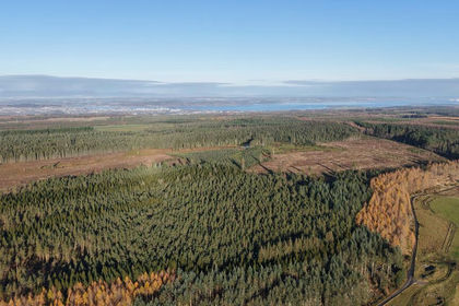
- Price
- Offers in Excess of£3,500,000
- Size
- 890.82 acres
Added on 19/08/2026Timberland