Balchimmy Plantation, Milton of Cushnie, Aberdeenshire, AB33
- Land size
- 566.17 acres
Description
An opportunity to acquire a diverse and productive,
young commercial plantation including 44,366 of high integrity Pending Issuance Units (Carbon Credits)
· Predominantly improved conifer crops
· Strong projected timber yields across the productive area
· 44,366 carbon credits generated under the Woodland Carbon Code
· A secure long-term asset combining timber and natural capital income
· Principal species comprising Norway spruce and Sitka spruce
· £150,361 of annual grant income secured until 2028
Description
Balchimmy Plantation is a well-established woodland of conifers and mixed broadleaves, planted on quality brown earth and fertile soils. The scheme is set to generate significant volumes of timber through regular thinnings and a final harvest.
Beyond its timber value, the plantation has generated 44,366 high-integrity Pending Issuance Units (PIUs), registered with the Woodland Carbon Code (WCC) and valuable for carbon offsetting. The site is classified as 4.1 and 4.2 on the Land Capability for Agriculture scale and rises from approximately 250m to 380m above sea level.
Forest Certification
The woodland is dual certified through Program for the Endorsement of Forest Certification (PEFC) and Forest Stewardship Council (FSC).
Carbon
The recently established woodland at Balchimmy represents a significant long-term carbon asset, with the planted trees projected to sequester 55,458 tonnes of CO₂e over 100 years. This is equivalent to the annual carbon emissions associated with more than 4,800 people in the UK.
After applying the Woodland Carbon Code’s required 20% buffer, the project is expected to generate approximately 44,366 verified carbon units available for future use or sale. This assessment is considered conservative, as the Woodland Carbon Code methodology applies capped yield class assumptions and assumes a harvesting date earlier than would typically be expected under good forestry management. The woodland therefore has potential to deliver greater carbon sequestration over its lifetime should growth exceed these conservative assumptions.
The units may be used to offset eligible emissions from personal or corporate activities, supporting net zero commitments, or alternatively monetised through sale to organisations seeking high-quality UK-based carbon credits.
A future owner will have flexibility over the timing and approach to realising this value. The woodland could be managed through a contracted strategy, with Woodland Carbon Units sold at pre-agreed pricing, potentially providing long-term income security through inflation-linked arrangements. Alternatively, a blended approach could be adopted — for example, selling a proportion of credits under forward contracts while retaining the balance for future sale into the open market or for the owner’s own carbon offsetting requirements as demand and pricing evolve.
The UK Government’s legally binding Net Zero target aims to reduce greenhouse gas emissions by 100% by 2050 compared with 1990 levels.
Map Location
Property details
- Tenure
- Ask Agent
- Council Tax Band
- Ask Agent
- Date Posted
- 2026-07-14
Market Value Analysis
Compared with 8 Woodland listings in Scotland (500+ acres).
Utilities & Restrictions
Utilities
- Electricity
- Ask Agent
- Water
- Ask Agent
- Heating
- Ask Agent
- Broadband
- Ask Agent
- Sewerage
- Ask Agent
Rights & Restrictions
- Public Rights of Way
- Ask Agent
- Private Rights of Way
- Ask Agent
- Listed Property
- Ask Agent
- Restrictions
- Ask Agent
Listed status, conservation areas and planning constraints for this location are in the full report.
Property Features
- Accessibility
- Ask Agent
- Parking
- Ask Agent
- Garden
- Ask Agent
Beyond the particulars: planning activity, flood history, heritage and ground risks, checked for this exact spot.
Connectivity
Broadband
Fastest speed available at this postcode
80 Mbps
Superfast · available to 36% of premises
Suitable for
- HD streaming
- Video calls
- Web & social
Mobile signal
Predicted 4G and 5G signal; indoor signal depends on building materials.
Ofcom Connected Nations postcode-level predictions. Speeds and signal are modelled, not measured, and vary between addresses and providers.
Signal is the easy part. Planning activity, flood history and protected designations here are in the full report.
Nearest Schools
Primary
- Towie School4.3 miles
- Pupils
- 38
- Type
- Non-denominational
- Craigievar School4.3 miles
- Pupils
- 35
- Type
- Non-denominational
- Tarland School4.5 miles
- Pupils
- 85
- Type
- Non-denominational
- Alford Primary School4.7 miles
- Pupils
- 343
- Type
- Non-denominational
- Tullynessle School5.4 miles
- Pupils
- 14
- Type
- Non-denominational
Secondary
- Alford Academy4.7 miles
- Pupils
- 733
- Type
- Non-denominational
- Aboyne Academy8.2 miles
- Pupils
- 669
- Type
- Non-denominational
- Kemnay Academy14 miles
- Pupils
- 993
- Type
- Non-denominational
- Banchory Academy16 miles
- Pupils
- 865
- Type
- Non-denominational
- Inverurie Academy18 miles
- Pupils
- 1,292
- Type
- Non-denominational
Distances are straight-line from the advertised location. Source: the national school registers (DfE, Welsh Government, Scottish Government) and Ofsted.
Schools are just the start: planning activity, heritage and any flood history here are in the full report.
Amenities
Supermarket
GP surgery
Pharmacy
Straight-line distances from the advertised location. Sources: NHS records, Geolytix supermarket locations, OS Open Greenspace and the national trails registers.
The area stacks up? Now check the location itself: planning nearby, protected designations and past flooding.
Getting Around
Nearest station
Nearest bus stop
Typical drive times
Straight-line distances from the advertised location; drive times are typical free-flow times over OpenStreetMap road data, so allow more at peak. Public transport locations from DfT NaPTAN.
Easy to reach matters. So do planning activity, flood history and ground risks: all in the full report.
Flood Risk
SEPA open data, checked around the advertised map pin for the listed acreage. Provided by LandSale, not the listing agent, and not part of the agent's particulars. Risk varies across a holding, so verify before committing.
Rivers and the sea
Not at the pin: mapped about 810 metres away.
Surface water
These bandings are the summary. Where this location sits on the flood maps, plus planning activity, heritage and ground risks, is in the full report.
Important notice: Information, maps and tags on this page are drawn from the advertising agent's marketing materials or generated automatically. LandSale has not verified them. Relying on these details is at your own risk, always carry out independent checks before committing to a purchase.
LandSale full disclaimer
Marketing information only - not formal particulars. The details on this website are provided for general guidance and do not constitute an offer or contract. Neither LandSale nor the advertising estate/land agent accepts responsibility for any inaccuracy.
1. Source of information
- Listing content: Core description, asking price, tenure, measurements, photographs and planning history originate from the marketing materials of the advertising estate or land agent. LandSale does not author this content and cannot guarantee its accuracy.
- Automated tags & categorisation: Property type, land-use class, acreage bands and similar labels may be applied by machine-learning models. They are intended as a helpful guide only and may not reflect the property's legal status or permitted use.
- Third-party & enriched data layers: Maps, boundary outlines, planning designations, soil reports, broadband coverage and other environmental or location-based insights are licensed from external suppliers. Such data are supplied “as is", may be incomplete or out of date and are subject to change without notice.
2. Verification required
Prospective purchasers must verify critical matters, including but not limited to planning permission, title boundaries, public rights of way, environmental constraints, acreage, services, access and VAT status, through their own inspections, specialist surveys, legal advisers and the selling agent before relying on the information or entering into any contract.
3. No warranty or liability
LandSale gives no warranty, express or implied, as to the accuracy, completeness or fitness for any particular purpose of the information displayed. LandSale shall not be liable for any loss, damage, cost or expense arising directly or indirectly from any use of or reliance on such information, save where liability may not be excluded by law.
4. Updates & feedback
If you believe any detail on this listing is inaccurate, please let us know. We will investigate and, where appropriate, update the listing or notify the agent.
© LandSale | Version 1.3 - August 2026

Listing agent
GOLDCREST LAND & FORESTRY GROUP LLP, Edinburgh
18 Great Stuart Street Edinburgh EH3 7TN
Contact GOLDCREST LAND & FORESTRY GROUP LLP, Edinburgh
18 Great Stuart Street Edinburgh EH3 7TN
View agent profileNearby properties for sale
- Price
- Offers in Region of£150,000
- Size
- 1.51 acres
Added on 03/09/2026Development Land
- Price
- Offers in Excess of£50,000
- Size
- 13.2 acres
Added on 11/09/2026Grazing Land
- Price
- Offers in Excess of£80,000
- Size
- 10.38 acres
Added on 11/09/2026Grazing Land
- Price
- Offers in Excess of£700,000
- Size
- 117.8 acres
Added on 11/09/2026Farm- Price
- £550,000
- Size
- 92.81 acres
Added on 18/09/2026Farmland
- Price
- Offers Over£250,000
- Size
- 64 acres
Land at Westside of Edingarioch, Premnay, AB52, Gordon and Buchan, Aberdeenshire AB52 Scotland
Added on 01/05/2026Agricultural Land
- Price
- Offers in Excess of£1,550,000
- Size
- 8 acres
Oyne, Aberdeenshire, AB52, Gordon and Buchan, Aberdeenshire AB52 Scotland
Added on 24/08/2026House with Land
- Price
- Guide Price£3,000
Pitmachie Septic Tank, Old Rayne, AB526RX, Gordon and Buchan, Aberdeenshire AB52 Scotland
Added on 08/08/2026Small Plot of Land
- Price
- Offers Over£450,000
- Size
- 7 acres
Logie Woodlands, Pitcaple, Inverurie, AB51, Gordon and Buchan, Aberdeenshire AB51 Scotland
Added on 29/01/2026Country Home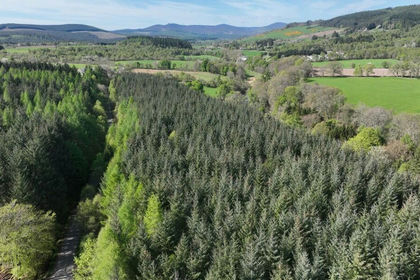
- Price
- Offers Over£75,000
- Size
- 11.22 acres
Affrusk Woodland, Banchory AB31, West Aberdeenshire and Kincardine, Aberdeenshire AB31 Scotland
Added on 29/01/2026Timberland