Land at Woodhead Road, Holmbridge, Holmfirth, West Yorkshire HD9
- Land size
- 0.08 acres
Key Features
- Freehold plot
- Fantastic location in Holmbridge village, nearby to Holmfirth
- Residential development plot with lapsed planning
Description
This property remains available and open to offers following the auction on 24 August 2026.
Please contact the auctioneers for further details.
A rare opportunity to acquire a freehold development site extending to approximately 0.08 acres, formerly occupied by a fish and chip shop, situated in a prominent roadside position fronting Woodhead Road (A6024) in the popular village of Holmbridge (HD9 2NW).
The site benefits from lapsed planning permission, originally granted in 2017, for the construction of an impressive three-storey detached dwelling. The approved scheme comprises a spacious and thoughtfully designed family home, featuring an open-plan kitchen/living/dining area, bathroom, utility room and a ground floor bedroom. The first floor provides four further bedrooms, including a principal bedroom with en-suite, together with an additional living room and shower room. A lower ground floor incorporates an integral garage, creating a substantial and versatile residential property.
Occupying a highly visible position on the A6024, the site enjoys convenient access to the amenities of Holmfirth, whilst being surrounded by attractive Pennine countryside. The previous planning approval demonstrates the site's residential potential, offering purchasers an excellent opportunity to pursue a similar scheme, subject to obtaining the necessary consents.
This is an ideal opportunity for developers, builders or self-builders seeking a well-located plot with established residential precedent in a highly desirable West Yorkshire location.
Note: Please be advised that the auctioneers have not personally inspected the property. Prospective buyers are advised to make a viewing enquiry and any other necessary independent enquiries before placing their bid, as this will be binding.
Tenure: Freehold
EPC Rating: NA
Terms:
Auction Details
The sale of this property will take place on the stated date by way of Multi lot timed auction and is being sold under the Unconditional sale type.
Binding contracts will be exchanged at the point of sale.
All sales are subject to our Common Auction Conditions and Bidder Terms. Properties located in Scotland and Northern Ireland will be subject to applicable local laws.
Auction Deposit and Fees
The following deposits and non-refundable auctioneers fees apply, and are payable immediately upon exchange of contracts:
• 10% deposit (subject to a minimum of £5,000)
• Buyer’s Fee of 1.8% inc. VAT of the purchase price (subject to a minimum of £2,400 inc. VAT)
There may be additional fees listed in the Special Conditions of Sale, which will be available to view within the Legal Pack. You must read the Legal Pack carefully before bidding.
Additional Information
For full details about our auction processes, please refer to the Bidder Terms which can be viewed on our home page.
This explains the types of auction and sale methods we offer, the bidding registration process, your payment obligations, and how to view the Legal Pack (and any applicable home report for residential Scottish properties).
Guide Price & Reserve Price
Each property sold is subject to a Reserve Price. The Reserve Price will be within + or - 10% of the Guide Price. The Guide Price is issued solely as a guide so that a buyer can consider whether or not to pursue their interest. A full definition can be found within the Buyers Terms.
Map Location
Property details
- Tenure
- Freehold
- Council Tax Band
- Ask Agent
- Date Posted
- 2026-07-15
Utilities & Restrictions
Utilities
- Electricity
- Ask Agent
- Water
- Ask Agent
- Heating
- Ask Agent
- Broadband
- Ask Agent
- Sewerage
- Ask Agent
Rights & Restrictions
- Public Rights of Way
- Ask Agent
- Private Rights of Way
- Ask Agent
- Listed Property
- Ask Agent
- Restrictions
- Ask Agent
Listed status, conservation areas and planning constraints for this location are in the full report.
Property Features
- Accessibility
- Ask Agent
- Parking
- Parking Available
- Garden
- Ask Agent
Beyond the particulars: planning activity, flood history, heritage and ground risks, checked for this exact spot.
Connectivity
Broadband
Fastest speed available at this postcode
80 Mbps
Superfast
Suitable for
- HD streaming
- Video calls
- Web & social
Fixed wireless access may also be an option here.
Mobile signal
Predicted 4G and 5G signal; indoor signal depends on building materials.
Ofcom Connected Nations postcode-level predictions. Speeds and signal are modelled, not measured, and vary between addresses and providers.
Signal is the easy part. Planning activity, flood history and protected designations here are in the full report.
Nearest Schools
Primary
- Hinchliffe Mill Junior and Infant School257 metresNo Ofsted rating
- Ages
- 4 to 11
- Pupils
- 51
- Type
- Community school
- Upperthong Junior and Infant School0.9 milesNo Ofsted rating
- Ages
- 4 to 11
- Pupils
- 209
- Type
- Community school
- Holme Junior and Infant School1.1 milesNo Ofsted rating
- Ages
- 4 to 11
- Pupils
- 28
- Type
- Community school
- Holmfirth Junior Infant and Nursery School1.4 milesNo Ofsted rating
- Ages
- 3 to 11
- Pupils
- 191
- Type
- Community school
- Hade Edge Junior, Infant and Nursery School1.6 milesOfsted: Requires improvement
- Ages
- 3 to 11
- Pupils
- 88
- Type
- Community school
Secondary
- Holmfirth High School2.5 milesOfsted: Outstanding
- Ages
- 11 to 16
- Pupils
- 1,328
- Type
- Community school
- Honley High School3.7 milesNo Ofsted rating
- Ages
- 11 to 16
- Pupils
- 1,240
- Type
- Academy converter
- Colne Valley High School4.7 milesOfsted: Good
- Ages
- 11 to 16
- Pupils
- 1,360
- Type
- Academy sponsor led
- Newsome Academy4.8 milesOfsted: Good
- Ages
- 11 to 16
- Pupils
- 824
- Type
- Academy sponsor led
- Moor End Academy5 milesOfsted: Outstanding
- Ages
- 11 to 16
- Pupils
- 1,053
- Type
- Academy converter
Distances are straight-line from the advertised location. Source: the national school registers (DfE, Welsh Government, Scottish Government) and Ofsted.
Schools are just the start: sold prices nearby, planning activity and any flood history are in the full report.
Amenities
Supermarket
GP surgery
Pharmacy
Hospital
Green space
Straight-line distances from the advertised location. Sources: NHS records, Geolytix supermarket locations, OS Open Greenspace and the national trails registers.
The area stacks up? Now check the location itself: planning nearby, protected designations and past flooding.
Getting Around
Nearest station
Nearest bus stop
Typical drive times
Straight-line distances from the advertised location; drive times are typical free-flow times over OpenStreetMap road data, so allow more at peak. Public transport locations from DfT NaPTAN.
Easy to reach matters. So do planning activity, flood history and ground risks: all in the full report.
Flood Risk
Environment Agency open data, checked around the advertised map pin for the listed acreage. Long-term risk counts flood defences; the planning map's flood zones do not. Provided by LandSale, not the listing agent, and not part of the agent's particulars. Risk varies across a holding, so verify before committing.
Rivers and the sea
Planning map: Flood Zone 1.
Surface water
Not at the pin: mapped about 20 metres away.
These bandings are the summary. Where this location sits on the flood maps, plus planning activity, heritage and ground risks, is in the full report.
Important notice: Information, maps and tags on this page are drawn from the advertising agent's marketing materials or generated automatically. LandSale has not verified them. Relying on these details is at your own risk, always carry out independent checks before committing to a purchase.
LandSale full disclaimer
Marketing information only - not formal particulars. The details on this website are provided for general guidance and do not constitute an offer or contract. Neither LandSale nor the advertising estate/land agent accepts responsibility for any inaccuracy.
1. Source of information
- Listing content: Core description, asking price, tenure, measurements, photographs and planning history originate from the marketing materials of the advertising estate or land agent. LandSale does not author this content and cannot guarantee its accuracy.
- Automated tags & categorisation: Property type, land-use class, acreage bands and similar labels may be applied by machine-learning models. They are intended as a helpful guide only and may not reflect the property's legal status or permitted use.
- Third-party & enriched data layers: Maps, boundary outlines, planning designations, soil reports, broadband coverage and other environmental or location-based insights are licensed from external suppliers. Such data are supplied “as is", may be incomplete or out of date and are subject to change without notice.
2. Verification required
Prospective purchasers must verify critical matters, including but not limited to planning permission, title boundaries, public rights of way, environmental constraints, acreage, services, access and VAT status, through their own inspections, specialist surveys, legal advisers and the selling agent before relying on the information or entering into any contract.
3. No warranty or liability
LandSale gives no warranty, express or implied, as to the accuracy, completeness or fitness for any particular purpose of the information displayed. LandSale shall not be liable for any loss, damage, cost or expense arising directly or indirectly from any use of or reliance on such information, save where liability may not be excluded by law.
4. Updates & feedback
If you believe any detail on this listing is inaccurate, please let us know. We will investigate and, where appropriate, update the listing or notify the agent.
© LandSale | Version 1.3 - August 2026
Listing agent
BTG Eddisons Property Auctions, Commercial Nationwide
340 Deansgate, Manchester, M3 4LY
Contact BTG Eddisons Property Auctions, Commercial Nationwide
340 Deansgate, Manchester, M3 4LY
View agent profileSimilar properties for sale
- Price
- Guide Price£30,000
- Size
- 0.07 acres
Land at Stocks Bank Road, Mirfield, West Yorkshire WF14, Mirfield, Kirklees WF14 England
Added on 09/10/2026Brownfield Land Added on 29/01/2026Building Plot
- Price
- Offers in Excess of£40,000
FOR SALE - Land adj to 10 Broadbent Road, Oldham, Oldham East and Saddleworth, Oldham OL1 England
Added on 16/04/2026Building Plot
- Price
- Guide Price£25,000
- Size
- 0.52 acres
Range Bank, Halifax, Calderdale, Halifax, Calderdale HX3 England
Added on 01/09/2026Amenity Land
- Price
- Guide Price£25,000
Added on 11/06/2026Development Land
- Price
- Guide Price£25,000
Land Adjoining 3A Lumn Road, Greater Manchester, Hyde, Stalybridge and Hyde, Tameside SK14 England
Added on 13/08/2026Self Build Plot
- Price
- Offers Over£40,000
Surrey Close, Barnsley, S70, Barnsley South, Barnsley S70 England
Added on 07/10/2026Building Plot Added on 18/06/2026Self Build Plot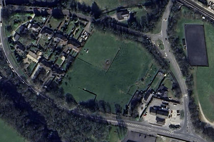
- Price
- Guide Price£30,000
- Size
- 0.3 acres
Hathersage Road, Bamford, Hope Valley, S33, Bamford, Derbyshire S33 England
Added on 03/02/2026Building Plot
- Price
- Guide Price£25,000
- Size
- 0.05 acres
Land to the rear of Yeadon road, Gorton, Gorton and Denton, Manchester M18 England
Added on 19/03/2026Undeveloped Land