Egmanton, Newark, Nottinghamshire
- Land size
- 3.7 acres
Description
Opportunity to acquire 3.7 acres (1.5 hectares) or thereabouts of agricultural land with the benefit of planning permission for residential development.
**For sale by informal tender**
The Site
Moat Farm extends to 3.7 acres (1.5 ha) or thereabouts and is situated on the northern side of Kirton Road, Egmanton. The site comprises a range of traditional farm buildings, now in disrepair and requiring redevelopment. To the north of the buildings lies a paddock and area of spinney which is included within the sale boundary.
The site rises gently from its southern boundary to its northern edge. At the highest point, near the northern boundary, the ground sits at approximately 50 m above Ordnance Datum (AOD). From there the site falls by around ten metres over a distance of roughly 200 m, reaching about 40 m AOD at the southern edge. This north-to-south gradient is shallow.
Constraints
There are small pockets of Flood Zone 2 touching the southern edge, covering just 0.19 % of the total site area. The remainder of the land sits safely within Flood Zone 1.
Adjacent to the Site are several listed buildings: PORTLAND FARMHOUSE (170.45m southeast, Grade II), CHURCH OF ST MARY (246.72m east, Grade I), ISLAND FARMHOUSE (59.67m south, Grade II), BARN SOUTH EAST OF STONE HOUSE (67.02m southwest, Grade II), and STONE HOUSE (98.36m southwest, Grade II).
The Site is entirely identified as a coal mining reporting area.
The land is located within a conservation area and lies close to several listed buildings; however, the physical and environmental constraints are relatively modest and largely manageable through considered design, standard mitigation and early technical due diligence.
Planning
The site is located within the jurisdiction of Newark and Sherwood District Council and benefits from planning permission for “Conversion of farm buildings to two dwellings (Plots 2-3) and rebuilding of one barn on existing footprint to form one dwelling (Plot 4). Replacement dwelling (Plot 5) and two new cart sheds.” (Planning ref: 23/00709/FUL).
The application was granted in May 2024 subject to conditions, including commencement of development within three years. The permission will expire in May 2027. In April 2025, a submission was made to discharge condition 6, which related to biodiversity enhancement and mitigation. The condition was partly discharged, more information can be found on the local authorities planning portal, or can be provided by the agent.
Location
Egmanton is an attractive rural village situated to the northwest of Newark-on-Trent in Nottinghamshire. The village offers a peaceful countryside setting with a close-knit community atmosphere, centred around a traditional village hall and parish church. The village is well placed for access to everyday amenities, with Tuxford 1.2 miles to the northeast and Newark-on-Trent located approximately 8 miles to the southeast. Tuxford benefits from a range of supermarkets, independent shops, cafés, restaurants and leisure facilities.
Primary education is typically served by nearby villages, with a wider selection of schools available in Tuxford and Newark-on-Trent, including Tuxford Academy (Ofsted rated ‘Good’) and The Newark Academy, providing options for secondary education. Further educational facilities, including colleges, can also be found within Newark and the wider district.
Egmanton benefits from road links via the A1, which lies a short distance to the west, providing convenient connections to regional centres including Lincoln, Nottingham and Doncaster. Rail services are available from Newark North Gate and Newark Castle stations, offering direct connections to London, Leeds and other major destinations.
Local Planning Authority
Newark and Sherwood District Council, Castle House, Great North Road, Newark, Nottinghamshire NG24 1BY
Community Infrastructure Levy
It is our understanding that Newark & Sherwood District Council is a CIL charging authority. Parties should familiarise themselves with the obligations.
Tenure and possession
The site will be sold freehold, with vacant possession given on completion.
Method of sale
The site is to be sold by informal tender with interested parties invited to submit offers using the tender form, available from the selling agents.
Overage
The vendor wishes to include an overage on the rear portion of the site. Offers are anticipated to include an overage, specifying the value of the uplift and the length.
Rights of Way, Wayleaves and Easements
The site is sold subject to all Rights of Way, Wayleaves and Easements whether or not they are defined in the marketing material.
Viewings
The Site can be seen from Kirton Road. Please contact the Agent should you have any further queries.
The Landowner nor their Agent take any responsibility for loss of injury on the Property, and all viewings are undertaken at that person’s own risk.
Mineral, Sporting and Timber Rights
As far as they are owned, the mineral, sporting and timber rights are included in the freehold sale.
Interested parties to undertake their own investigations and satisfy themselves on these rights.
VAT
The sale will be subject to VAT, and all offers should be clearly stated as a figure plus VAT.
Plans, schedules and boundaries
The plans and schedules within these particulars are based on ordnance survey data and are provided for reference only. They are believed to be correct, but accuracy is not guaranteed. The Purchaser shall be deemed to have full knowledge of all the boundaries and extent of ownership. Neither the Vendor nor their Agent will be responsible for defining boundaries or the ownership thereof.
Costs
The Purchaser will be responsible for the Landowner’s legal costs which are to be non-deductible and non- refundable.
Method of sale
The site is to be sold by informal tender, with interested parties invited to submit offers in writing addressing the points listed below.
Offers must be compliant with the requirements set out within the covering email and these particulars.
Offers should made in writing, not related to any other offers and should include as a minimum:
- The unconditional sum
- Confirmation of any pre-exchange qualifications associated with the offer
- Payment profile and availability of funds
- Any assumptions relating to abnormal development costs
- A synopsis of planning and technical due diligence undertaken
- Board approval process and associated timescales
- Solicitor’s details
- Any proposed overage payments to the Seller
Map Location
Property details
- Tenure
- Freehold
- Council Tax Band
- TBC
- Date Posted
- 2026-07-12
Market Value Analysis
Compared with 7 Brownfield & Redevelopment listings in East Midlands (1+ acres).
Utilities & Restrictions
Utilities
- Electricity
- Ask Agent
- Water
- Ask Agent
- Heating
- Ask Agent
- Broadband
- Ask Agent
- Sewerage
- Ask Agent
Rights & Restrictions
- Public Rights of Way
- Ask Agent
- Private Rights of Way
- Ask Agent
- Listed Property
- Ask Agent
- Restrictions
- Ask Agent
Listed status, conservation areas and planning constraints for this location are in the full report.
Property Features
- Accessibility
- Ask Agent
- Parking
- Ask Agent
- Garden
- Garden
Beyond the particulars: planning activity, flood history, heritage and ground risks, checked for this exact spot.
Connectivity
Broadband
Fastest speed available at this postcode
1.8 Gbps
Gigabit full fibre
Suitable for
- 4K streaming on every screen
- Full-time home working
- Online gaming & big downloads
Mobile signal
Predicted 4G and 5G signal; indoor signal depends on building materials.
Ofcom Connected Nations postcode-level predictions. Speeds and signal are modelled, not measured, and vary between addresses and providers.
Signal is the easy part. Planning activity, flood history and protected designations here are in the full report.
Nearest Schools
Primary
- Tuxford Primary Academy1.3 milesNo Ofsted rating
- Ages
- 3 to 11
- Pupils
- 224
- Type
- Academy sponsor led
- East Markham Primary School2.9 milesNo Ofsted rating
- Ages
- 3 to 11
- Pupils
- 200
- Type
- Community school
- Kneesall CofE Primary Academy3.3 milesOfsted: Good
- Ages
- 3 to 11
- Pupils
- 104
- Type
- Academy converter
- Faith
- Church of England
- Walesby CofE Primary School3.4 milesOfsted report card · Apr 2026
- Ages
- 4 to 11
- Pupils
- 90
- Type
- Voluntary controlled school
- Faith
- Church of England
- St Matthew's CofE Primary School3.6 milesNo Ofsted rating
- Ages
- 3 to 11
- Pupils
- 69
- Type
- Academy converter
- Faith
- Church of England
Secondary
- Tuxford Academy1.7 milesOfsted: Good
- Ages
- 11 to 18
- Pupils
- 1,462
- Type
- Academy converter
- The Dukeries Academy4 milesOfsted report card · Mar 2026
- Ages
- 11 to 16
- Pupils
- 709
- Type
- Academy sponsor led
- Retford Oaks Academy7.8 milesNo Ofsted rating
- Ages
- 11 to 18
- Pupils
- 1,080
- Type
- Academy sponsor led
- The Elizabethan Academy8.5 milesOfsted: Good
- Ages
- 11 to 18
- Pupils
- 1,230
- Type
- Academy converter
- The Minster School9.9 milesOfsted: Good
- Ages
- 7 to 18
- Pupils
- 1,616
- Type
- Academy converter
- Faith
- Church of England
Distances are straight-line from the advertised location. Source: the national school registers (DfE, Welsh Government, Scottish Government) and Ofsted.
Schools are just the start: sold prices nearby, planning activity and any flood history are in the full report.
Amenities
Supermarket
GP surgery
Pharmacy
Hospital
Straight-line distances from the advertised location. Sources: NHS records, Geolytix supermarket locations, OS Open Greenspace and the national trails registers.
The area stacks up? Now check the location itself: planning nearby, protected designations and past flooding.
Getting Around
Nearest station
Nearest bus stop
Typical drive times
Straight-line distances from the advertised location; drive times are typical free-flow times over OpenStreetMap road data, so allow more at peak. Public transport locations from DfT NaPTAN.
Easy to reach matters. So do planning activity, flood history and ground risks: all in the full report.
Flood Risk
Environment Agency open data, checked around the advertised map pin for the listed acreage. Long-term risk counts flood defences; the planning map's flood zones do not. The map pin for this listing marks the postcode area rather than the exact location, so these readings describe the surrounding area. Provided by LandSale, not the listing agent, and not part of the agent's particulars. Risk varies across a holding, so verify before committing.
Rivers and the sea
Not at the pin: mapped about 40 metres away.
Planning map: Flood Zone 3, about 20 metres away.
Surface water
Not at the pin: mapped about 10 metres away.
These bandings are the summary. Where this location sits on the flood maps, plus planning activity, heritage and ground risks, is in the full report.
Important notice: Information, maps and tags on this page are drawn from the advertising agent's marketing materials or generated automatically. LandSale has not verified them. Relying on these details is at your own risk, always carry out independent checks before committing to a purchase.
LandSale full disclaimer
Marketing information only - not formal particulars. The details on this website are provided for general guidance and do not constitute an offer or contract. Neither LandSale nor the advertising estate/land agent accepts responsibility for any inaccuracy.
1. Source of information
- Listing content: Core description, asking price, tenure, measurements, photographs and planning history originate from the marketing materials of the advertising estate or land agent. LandSale does not author this content and cannot guarantee its accuracy.
- Automated tags & categorisation: Property type, land-use class, acreage bands and similar labels may be applied by machine-learning models. They are intended as a helpful guide only and may not reflect the property's legal status or permitted use.
- Third-party & enriched data layers: Maps, boundary outlines, planning designations, soil reports, broadband coverage and other environmental or location-based insights are licensed from external suppliers. Such data are supplied “as is", may be incomplete or out of date and are subject to change without notice.
2. Verification required
Prospective purchasers must verify critical matters, including but not limited to planning permission, title boundaries, public rights of way, environmental constraints, acreage, services, access and VAT status, through their own inspections, specialist surveys, legal advisers and the selling agent before relying on the information or entering into any contract.
3. No warranty or liability
LandSale gives no warranty, express or implied, as to the accuracy, completeness or fitness for any particular purpose of the information displayed. LandSale shall not be liable for any loss, damage, cost or expense arising directly or indirectly from any use of or reliance on such information, save where liability may not be excluded by law.
4. Updates & feedback
If you believe any detail on this listing is inaccurate, please let us know. We will investigate and, where appropriate, update the listing or notify the agent.
© LandSale | Version 1.3 - August 2026
Listing agent
Fisher German, Covering Yorkshire & The Humber
Lakeside Business Park 2 Carolina Court Doncaster PE8 6JR
View agent profileSimilar properties for sale
- Price
- £700,000
- Size
- 1.6 acres
Added on 26/04/2026Redevelopment Land
- Price
- Guide Price£750,000
- Size
- 2.5 acres
Added on 28/05/2026Self Build Plot
- Price
- Offers Over£775,000
- Size
- 1.6 acres
Old Grange Farm Main Street, South Muskham, Newark, South Muskham, Nottinghamshire NG23 England
Added on 29/01/2026Development Land
- Price
- Guide Price£550,000
- Size
- 74.34 acres
Retford, Nottinghamshire, North Leverton with Habblesthorpe, Nottinghamshire DN22 England
Added on 28/08/2026Agricultural Land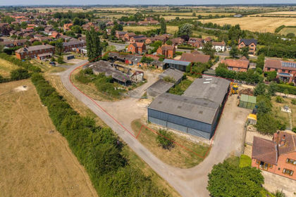
- Price
- From£550,000
- Size
- 1.01 acres
Claypole, Newark, Lincolnshire, Claypole, Lincolnshire NG23 England
Added on 11/08/2026Development Land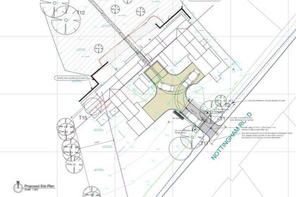
- Price
- Guide Price£500,000
- Size
- 1 acres
Development Land, Nottingham Road, Bulcote, Nottingham, Lowdham, Nottinghamshire NG14 England
Added on 29/01/2026Building Plot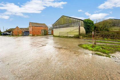
- Price
- Offers in Region of£600,500
- Size
- 2.05 acres
Dry Doddington, Newark, Westborough and Dry Doddington, Lincolnshire NG23 England
Added on 07/03/2026Development Land
- Price
- £675,000
- Size
- 3.75 acres
Dog Kennels Lane, Kiveton Park, Sheffield, S26, North and South Anston, Rotherham S26 England
Added on 29/01/2026Development Land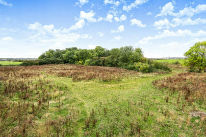
- Price
- £600,000
- Size
- 2.05 acres
Added on 29/01/2026Development Land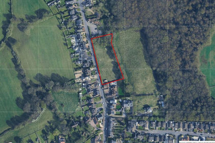
- Price
- Guide Price£750,000
- Size
- 1.08 acres
Added on 08/08/2026Development Land