Pateley Bridge, Harrogate, North Yorkshire
- Land size
- 3.96 acres
- Bedrooms
- 5
- Bathrooms
- 4
Key Features
- Substantial detached farmhouse in 4 acres
- Comprehensively modernised over last 2 years
- Opportunity for off-grid living
- Personalise the final fit-out
- Spacious open plan living areas
- Generous 5 bedroom layout
- Stables and garaging/workshop
- Enticing Nidderdale setting
Description
A generously proportioned 5 bedroom detached farmhouse in 4 acres of wonderful Nidderdale countryside, comprehensively improved and extending to around 3800 sq. Offered with scope for personalisation, along with garaging and stables, just a short distance from excellent local facilities in Pateley Bridge.
Situation - Bishopside Farmhouse sits in the heart of Nidderdale, being a designated National Landscape (formerly AONB) but yet the country setting belies the convenience of being only a few minutes’ drive from an extensive range of facilities in the picturesque town of Pateley Bridge. The elevated position affords lovely views over the Dale and surrounding farmland, and the property sits well within its own holding. The cathedral city of Ripon and Spa town of Harrogate are 12 and 15 miles respectively.
In an era of rising living costs and ongoing uncertainty around gas and oil prices, this property offers a rare blend of resilience, sustainability and long term value. Already equipped with a ground source heat pump, high performance insulation, double glazing and low energy lighting throughout, it delivers exceptional efficiency and predictability of running costs without compromising comfort. Forward thinking infrastructure, including pre installed cabling for solar panels and battery storage, allows a future owner to further enhance energy independence with minimal disruption. Coupled with a private spring fed water supply and private sewerage system, the property presents a compelling opportunity for largely off grid living—an increasingly desirable proposition for discerning buyers seeking control, discretion and environmental stewardship. For the right clientele, this is not merely a home, but a strategic investment in self sufficiency and future proofed luxury.
Description - Over the last 2 years, the property has been the subject of significant improvement with the specific intention of creating a 21st century home within what is believed to be an early 18th century shell. As such the property has been modernised from the roof downwards including bespoke sealed unit double glazed windows, comprehensive timber replacement, complete rewiring with structured cabling and re-plumbing together with the installation of a ground source heating system and a new sewerage treatment plant. The internal layout has been reconfigured according to modern day living standards with the purchaser now having the opportunity to install kitchen and bathroom fitments, tiling and floor coverings according to personal choice and expense.
Accommodation - The generous living space extends to around 3600 sq ft, having a strong emphasis on being open plan and light, helped by all the rooms facing south-east. There is an immediate sense of arrival into a spacious dining hall with a feature staircase, and double-sided fireplace that opens to a fabulous large living kitchen area that is around 515 sq ft in its own right. Plumbing and electrical connections have already been strategically positioned for final fit out. There is a generously sized sitting room leading to the study/snug and then to the secondary kitchen area/utility having extensive plant equipment, plus a cloaks/shower room off.
All the bedrooms have enviable rural views over Nidderdale. A generous master suite on the western side is complimented by a guest suite at the eastern end with 3 bedrooms between (one with provision for an en-suite) plus a house bathroom. As with the kitchen fitout, the property is sold as seen with the purchaser having the opportunity to acquire and install sanitaryware and tiling, at their own expense post-acquisition.
Standing nicely in some 3.96 acres, there is an established garden, woodland and grassland together with stabling facilities (two loose boxes and tack room) plus a workshop/garage. There is also planning permission for a detached double garage positioned off the side driveway, and a new garden room to the front of the building.
Bishopside Farmhouse is a wonderful country house in an enviable setting in the heart of Nidderdale. With the major improvement works complete, together with appropriate certification, this is a unique opportunity for personalisation without the attendant delay and uncertainty often associated with significant projects of this nature.
Tenure - Freehold with vacant possession on completion.
Services - Mains electricity, private drainage and water, ground source heating being underfloor to the ground floor and radiators to the first floor.
Local Authority - North Yorkshire Council. Tax Band: G
Easements And Rights Of Way - The property is sold subject to and with the benefit of all existing wayleaves, easements, and rights of way, public and private, whether specifically mentioned or not.
Particulars And Photography - Particulars written: May 2025. Photography taken: May 2025. Digitally enhanced images (CGIs) have also been used.
Directions - From the village of Summerbridge, proceed on the B6165 towards Pateley, passing through Low Laithe, Wilsill and Glasshouses. At the top of the hill, turn tight onto B6265 towards Ripon. After approx. 0.25 miles, turn sharp left (allow space to take the turn). Proceed up the hill for approx. 0.3 miles, the property will then be seen on the left hand side.
What3words - ///trees.horns.alpha
Viewing Arrangements - Strictly by appointment through the selling agents GSC Grays
Disclaimer - GSC Grays gives notice that:
1. These particulars are a general guide only and do not form any part of any offer or contract.
2. All descriptions, including photographs, dimensions and other details are given in good faith but no warranty is provided. Statements made should not be relied upon as facts and anyone interested must satisfy themselves as to their accuracy by inspection or otherwise.
3. Neither GSC Grays nor the vendors accept responsibility for any error that these particulars may contain however caused.
4. Any plan is for guidance only and is not drawn to scale. All dimensions, shapes, and compass bearings are approximate and should not be relied upon without checking them first.
5. Nothing in these particulars shall be deemed to be a statement that the property is in good condition, repair or otherwise nor that any services or facilities are in good working order.
6. Please discuss with us any aspects that are important to you prior to travelling to the property.
Map Location
Property details
- Tenure
- Freehold
- Council Tax Band
- G
- Date Posted
- 2026-04-02
Market Value Analysis
Compared with 668 Homes with Land listings in Yorkshire and The Humber (1+ acres).
Energy Performance Certificate
Energy Efficiency Rating
Based on UK Energy Performance Certificate standards (EU Directive 2002/91/EC)
Running costs are one side. Planning activity, flood history and ground risks for this location are in the full report.
Utilities & Restrictions
Utilities
- Electricity
- Ask Agent
- Water
- Ask Agent
- Heating
- Ask Agent
- Broadband
- Ask Agent
- Sewerage
- Ask Agent
Rights & Restrictions
- Public Rights of Way
- Ask Agent
- Private Rights of Way
- Ask Agent
- Listed Property
- Ask Agent
- Restrictions
- Ask Agent
Listed status, conservation areas and planning constraints for this location are in the full report.
Property Features
- Accessibility
- Ask Agent
- Parking
- Parking Available
- Garden
- Garden
Beyond the particulars: planning activity, flood history, heritage and ground risks, checked for this exact spot.
Connectivity
Broadband
Fastest speed available at this postcode
36 Mbps
Superfast · available to 33% of premises
Suitable for
- HD streaming
- Video calls
- Web & social
Fixed wireless access may also be an option here.
Mobile signal
Predicted 4G and 5G signal; indoor signal depends on building materials.
Ofcom Connected Nations postcode-level predictions. Speeds and signal are modelled, not measured, and vary between addresses and providers.
Signal is the easy part. Planning activity, flood history and protected designations here are in the full report.
Nearest Schools
Primary
- Glasshouses Community Primary School0.7 milesOfsted report card · May 2026
- Ages
- 4 to 11
- Pupils
- 44
- Type
- Community school
- St Cuthbert's Church of England Primary School, Pateley Bridge0.8 milesOfsted: Good
- Ages
- 3 to 11
- Pupils
- 58
- Type
- Voluntary controlled school
- Faith
- Church of England
- Summerbridge Primary School2.6 milesOfsted: Good
- Ages
- 2 to 11
- Pupils
- 73
- Type
- Academy converter
- Dacre Braithwaite Church of England Primary School3.4 milesOfsted: Good
- Ages
- 5 to 11
- Pupils
- 77
- Type
- Academy converter
- Faith
- Church of England
- Darley Primary School4.5 milesNo Ofsted rating
- Ages
- 2 to 11
- Pupils
- 88
- Type
- Academy converter
Secondary
- Nidderdale High School1.3 milesOfsted report card · Apr 2026
- Ages
- 11 to 16
- Pupils
- 404
- Type
- Academy converter
- Outwood Academy Ripon8.9 milesOfsted: Good
- Ages
- 11 to 18
- Pupils
- 609
- Type
- Academy converter
- Ripon Grammar School9 milesOfsted: Good
- Ages
- 11 to 18
- Pupils
- 957
- Type
- Community school
- Harrogate Grammar School11 milesOfsted report card · Apr 2026
- Ages
- 11 to 18
- Pupils
- 2,081
- Type
- Academy converter
- Harrogate High School11 milesOfsted report card · Feb 2026
- Ages
- 11 to 16
- Pupils
- 579
- Type
- Academy converter
Distances are straight-line from the advertised location. Source: the national school registers (DfE, Welsh Government, Scottish Government) and Ofsted.
Schools are just the start: sold prices nearby, planning activity and any flood history are in the full report.
Amenities
Supermarket
GP surgery
Pharmacy
Hospital
Green space
Straight-line distances from the advertised location. Sources: NHS records, Geolytix supermarket locations, OS Open Greenspace and the national trails registers.
The area stacks up? Now check the location itself: planning nearby, protected designations and past flooding.
Getting Around
Nearest station
Nearest bus stop
Typical drive times
Straight-line distances from the advertised location; drive times are typical free-flow times over OpenStreetMap road data, so allow more at peak. Public transport locations from DfT NaPTAN.
Easy to reach matters. So do planning activity, flood history and ground risks: all in the full report.
Flood Risk
Environment Agency open data, checked around the advertised map pin for the listed acreage. Long-term risk counts flood defences; the planning map's flood zones do not. Provided by LandSale, not the listing agent, and not part of the agent's particulars. Risk varies across a holding, so verify before committing.
Rivers and the sea
Planning map: Flood Zone 1.
Surface water
These bandings are the summary. Where this location sits on the flood maps, plus planning activity, heritage and ground risks, is in the full report.
Important notice: Information, maps and tags on this page are drawn from the advertising agent's marketing materials or generated automatically. LandSale has not verified them. Relying on these details is at your own risk, always carry out independent checks before committing to a purchase.
LandSale full disclaimer
Marketing information only - not formal particulars. The details on this website are provided for general guidance and do not constitute an offer or contract. Neither LandSale nor the advertising estate/land agent accepts responsibility for any inaccuracy.
1. Source of information
- Listing content: Core description, asking price, tenure, measurements, photographs and planning history originate from the marketing materials of the advertising estate or land agent. LandSale does not author this content and cannot guarantee its accuracy.
- Automated tags & categorisation: Property type, land-use class, acreage bands and similar labels may be applied by machine-learning models. They are intended as a helpful guide only and may not reflect the property's legal status or permitted use.
- Third-party & enriched data layers: Maps, boundary outlines, planning designations, soil reports, broadband coverage and other environmental or location-based insights are licensed from external suppliers. Such data are supplied “as is", may be incomplete or out of date and are subject to change without notice.
2. Verification required
Prospective purchasers must verify critical matters, including but not limited to planning permission, title boundaries, public rights of way, environmental constraints, acreage, services, access and VAT status, through their own inspections, specialist surveys, legal advisers and the selling agent before relying on the information or entering into any contract.
3. No warranty or liability
LandSale gives no warranty, express or implied, as to the accuracy, completeness or fitness for any particular purpose of the information displayed. LandSale shall not be liable for any loss, damage, cost or expense arising directly or indirectly from any use of or reliance on such information, save where liability may not be excluded by law.
4. Updates & feedback
If you believe any detail on this listing is inaccurate, please let us know. We will investigate and, where appropriate, update the listing or notify the agent.
© LandSale | Version 1.3 - August 2026
Listing agent
GSC Grays, Boroughbridge
15-17 High Street, Boroughbridge, YO51 9AW
Similar properties for sale
- Price
- Guide Price£1,350,000
- Size
- 10 acres
Quarry Lane, Pateley Bridge, HG3, High and Low Bishopside, North Yorkshire HG3 England
Added on 16/09/2026Farmhouse
- Price
- £1,300,000
- Size
- 2 acres
Station Road, Darley, Harrogate, North Yorkshire, Darley and Menwith, North Yorkshire HG3 England
Added on 29/09/2026House with Land
- Price
- Guide Price£1,150,000
- Size
- 4 acres
Laverton, Nr Ripon, HG4, Laverton, North Yorkshire HG4 England
Added on 25/04/2026House with Land
- Price
- £1,795,000
- Size
- 10 acres
Ripley, Nr Harrogate, Clint cum Hamlets, North Yorkshire HG3 England
Added on 25/07/2026Equestrian property
- Price
- Guide Price£1,100,000
- Size
- 1.5 acres
Added on 30/05/2026Country Home
- Price
- Guide Price£1,300,000
- Size
- 3.3 acres
Ripley, Harrogate, North Yorkshire, HG3, Clint cum Hamlets, North Yorkshire HG3 England
Added on 07/05/2026Farmhouse
- Price
- Offers Over£1,500,000
- Size
- 4.6 acres
Rowden Lane, Hampsthwaite, HG3, Hampsthwaite, North Yorkshire HG3 England
Added on 26/02/2026House with Land
- Price
- Guide Price£1,600,000
- Size
- 17.5 acres
Spring Hall Farm, Grewelthorpe, Ripon, North Yorkshire HG4, Azerley, North Yorkshire HG4 England
Added on 02/10/2026Smallholding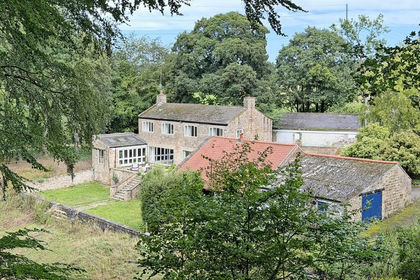
- Price
- £1,500,000
- Size
- 15 acres
Rock Hall, Nidd, Harrogate, Nidd, North Yorkshire HG3 England
Added on 17/09/2026Country Home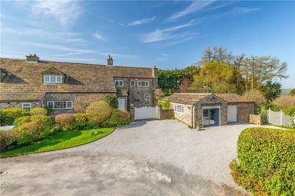
- Price
- Guide Price£1,450,000
- Size
- 1.6 acres
Added on 15/04/2026House with Land