Land To The South Of South Street, West Camel, Yeovil, BA22
- Land size
- 1.31 acres
Key Features
- Single Residential Development Plot
- Detailed Planning Permission for Detached House
- No Overage Clause
- The Site Extends to Approximately 1.31 Acres (0.53 ha)
- Ideal for Both Self Builders and Developers
Description
An opportunity to acquire an attractive building plot which benefits from detailed planning permission for the erection of a detached four bedroom dwelling with a Gross Internal Area (GIA) of approximately 3,986 sq. ft (370.35 sq.m). Situated in a rural location within the sought after village of West Camel, the site extends in total to approximately 1.31 acres (0.53 ha), ideal for both self builders and developers.
LOCATION
The site occupies a substantial plot within the desirable village of West Camel, some 6 miles north east of the town centre of Yeovil. The market town of Sherborne lies approximately 7 miles distant to south east.
West Camel has a small range of amenities including All Saints Church, a Public House (The Walnut Tree), playing fields and a community centre (The Davis Hall).
The neighbouring village of Queen Camel lies approximately 2 miles distant to the east and benefits from a range of facilities and amenities including (but not limited to): St Barnabas Parish Church, Countess Gytha Primary School, Queen Camel Memorial Hall, The Mildmay Arms, and Queen Camel Medical Centre.
COMMUNICATIONS
Road - The A303 is conveniently located just 0.5 miles to the north, providing links to the M5 motorway at Taunton (Junction 25) via the A358 and links to London.
Rail - Yeovil Junction is located approximately 9 miles to the south, Sherborne Railway Station is approximately 8 miles to the south east and Castle Cary Station is approximately 10 miles to the north east. All stations provide mainline services to destinations such as Exeter St David’s, London Paddington and London Waterloo.
Air - Bristol Airport is located approximately 38 miles to the north. It has scheduled and chartered flights to a range of national and international destinations. Exeter Airport is located approximately 46 miles to the south west.
BUILDING PLOT
The building plot is situated off Back Street, a well maintained public
highway, leading directly into the village. The site adjoins other
residential properties to the north, east and west and agricultural land
directly to the south.
The site benefits from detailed planning permission for the erection of
a detached, two storey, four bedroom dwelling. Planning Reference
Number: 23/02002/S73A. The plot currently comprises a single
enclosure of level pasture land extending, in total, to approximately
1.31 acres (0.53 ha) or thereabouts and is bound by mature
hedgerows. The site is shown edged red on the attached site plan. It is
shown for identification purposes only and is not to be relied upon.
PROPOSED NEW HOME
The proposed new home will comprise of 1no. Dwelling with a Gross
dwelling will be of natural stone construction beneath a slate tile roof
with four bedrooms to the first floor, three of which are Ensuite and
one jack and jill ensuite. The ground floor will comprise a gym and
sewing room, snug, open plan kitchen/dining area, living room, plant
room, W.C and boot room. The property comes with a garden and
kitchen garden.
ACCESS
Access is provided via the existing vehicle access from South Street via a gateway.
COMMUNITY INFRASTRUCTURE LEVY
We understand that Community Infrastructure Levy (CIL) will be
payable if the proposed new home is built by a housebuilder/
developer, but it will not be payable if it is built by a self-builder due to
an exemption for self-build schemes.
COVENA NTS
We are aware that there is a section 106 on the property. Please get in
touch with the selling agent for more information.
PHOSPHATES
Planning permission was granted in January 2024 and therefore phosphate mitigation is not required.
SERVICES
We understand that mains drainage, water and electric will be available on or near the plot. Ultrafast Fibre broadband is also available (Wessex Internet).
All interested parties should make their own enquiries with the Statutory Utility Providers.
MOBILE COVERAGE
For an indication of specific speeds and supply or coverage in the area we recommend contacting your own provider.
TENURE AND POSSESSION
The land is of freehold tenure with full vacant possession available upon completion of the purchase.
OVERAGE CLAUSE
There will be NO overage clause attached to the sale.
METHOD OF SALE
We are offering the freehold for sale by private treaty, with vacant possession on completion.
GUIDE PRICE
The guide price is £280,000.
VALUE ADDED TAX
The seller will not opt to tax; therefore, VAT will not be payable in addition to the purchase price.
All interested parties should make their own enquiries with HMRC.
RIGHTS OF WAY, WAYLEAVES AND EASEMENTS
There are no public rights of way. The sale is subject to all rights of support, public and private rights of way, water, light, drainage and other easements, quasi-easements, all or any other like rights, whether mentioned in these particulars or not.
VIEWINGS
The site can be viewed on foot at any reasonable time with a copy of these particulars in hand. Please observe the country code and ensure all gates are closed.
FLOOD ZONE
The property is in an area at a very low risk of flooding from River/Sea and Surface Water (defined as the chance of flooding each year as less than 0.1%).
LOCAL AUTHORITY
Somerset Council
The Council offices, Brympton Way, Yeovil, Somerset, BA20 2HT
W: https://www.somerset.gov.uk/
T: (01935) 462462
DIRECTIONS
Sat Nav: BA22 7QQ
What3Words: ///forgotten.reshaping.mentioned
From Yeovil, head north along Mudford Road (A359) for approximately 6 miles, passing through the villages of Mudford and Marston Magna. Take the first exit at the roundabout, as you enter Queen Camel and follow West camel Road for approximately 1.2 miles. Turn right onto Southmead Lane and continue on this road for approximately 0.2 miles. The gateway to the site is located on the right hand side, as indicated by a GTH for sale board.
Map Location
Property details
- Tenure
- Ask Agent
- Council Tax Band
- TBC
- Date Posted
- 2026-07-09
Price history
| Date | Change | Price |
|---|---|---|
| 24 Sep 2026 | Reduced 8.2% (−£25,000) | £280,000 |
| Until 24 Sep 2026 | Asking price | £305,000 |
Market Value Analysis
Compared with 50 Building Plots listings in South West England (1+ acres).
Property Brochure
Seen the details? The full report adds the independent checks: planning activity, flood history, heritage and ground.
Utilities & Restrictions
Utilities
- Electricity
- Ask Agent
- Water
- Ask Agent
- Heating
- Ask Agent
- Broadband
- Ask Agent
- Sewerage
- Ask Agent
Rights & Restrictions
- Public Rights of Way
- Ask Agent
- Private Rights of Way
- Ask Agent
- Listed Property
- Ask Agent
- Restrictions
- Ask Agent
Listed status, conservation areas and planning constraints for this location are in the full report.
Property Features
- Accessibility
- Ask Agent
- Parking
- Ask Agent
- Garden
- Garden
Beyond the particulars: planning activity, flood history, heritage and ground risks, checked for this exact spot.
Connectivity
Broadband
Fastest speed available at this postcode
1 Gbps
Gigabit full fibre
Suitable for
- 4K streaming on every screen
- Full-time home working
- Online gaming & big downloads
Mobile signal
Predicted 4G and 5G signal; indoor signal depends on building materials.
Ofcom Connected Nations postcode-level predictions. Speeds and signal are modelled, not measured, and vary between addresses and providers.
Signal is the easy part. Planning activity, flood history and protected designations here are in the full report.
Nearest Schools
Primary
- Countess Gytha Primary School1.2 milesOfsted: Good
- Ages
- 2 to 11
- Pupils
- 184
- Type
- Academy converter
- Ilchester Community School3.4 milesNo Ofsted rating
- Ages
- 2 to 11
- Pupils
- 322
- Type
- Academy converter
- Charlton Mackrell CofE Primary School3.7 milesOfsted: Good
- Ages
- 4 to 11
- Pupils
- 89
- Type
- Voluntary controlled school
- Faith
- Church of England
- Trent Young's CofE Primary School3.8 milesNo Ofsted rating
- Ages
- 4 to 11
- Pupils
- 143
- Type
- Academy converter
- Faith
- Church of England
- Keinton Mandeville Primary School4.1 milesOfsted: Good
- Ages
- 4 to 11
- Pupils
- 149
- Type
- Community school
Secondary
- Buckler's Mead School4.3 milesOfsted: Good
- Ages
- 11 to 16
- Pupils
- 812
- Type
- Academy converter
- Westfield Academy5.2 milesNo Ofsted rating
- Ages
- 11 to 16
- Pupils
- 1,013
- Type
- Academy converter
- Preston School Academy5.5 milesOfsted: Good
- Ages
- 11 to 16
- Pupils
- 1,003
- Type
- Academy converter
- The Gryphon School5.7 milesNo Ofsted rating
- Ages
- 11 to 18
- Pupils
- 1,569
- Type
- Academy converter
- Faith
- Church of England
- Ansford Academy6.7 milesOfsted report card · Feb 2026
- Ages
- 11 to 16
- Pupils
- 469
- Type
- Academy converter
Distances are straight-line from the advertised location. Source: the national school registers (DfE, Welsh Government, Scottish Government) and Ofsted.
Schools are just the start: sold prices nearby, planning activity and any flood history are in the full report.
Amenities
Supermarket
GP surgery
Pharmacy
Hospital
Green space
Straight-line distances from the advertised location. Sources: NHS records, Geolytix supermarket locations, OS Open Greenspace and the national trails registers.
The area stacks up? Now check the location itself: planning nearby, protected designations and past flooding.
Getting Around
Nearest station
Nearest bus stop
Typical drive times
Straight-line distances from the advertised location; drive times are typical free-flow times over OpenStreetMap road data, so allow more at peak. Public transport locations from DfT NaPTAN.
Easy to reach matters. So do planning activity, flood history and ground risks: all in the full report.
Flood Risk
Environment Agency open data, checked around the advertised map pin for the listed acreage. Long-term risk counts flood defences; the planning map's flood zones do not. Provided by LandSale, not the listing agent, and not part of the agent's particulars. Risk varies across a holding, so verify before committing.
Rivers and the sea
Not at the pin: mapped about 10 metres away.
Planning map: Flood Zone 3, about 30 metres away.
Surface water
Not at the pin: mapped about 10 metres away.
These bandings are the summary. Where this location sits on the flood maps, plus planning activity, heritage and ground risks, is in the full report.
Important notice: Information, maps and tags on this page are drawn from the advertising agent's marketing materials or generated automatically. LandSale has not verified them. Relying on these details is at your own risk, always carry out independent checks before committing to a purchase.
LandSale full disclaimer
Marketing information only - not formal particulars. The details on this website are provided for general guidance and do not constitute an offer or contract. Neither LandSale nor the advertising estate/land agent accepts responsibility for any inaccuracy.
1. Source of information
- Listing content: Core description, asking price, tenure, measurements, photographs and planning history originate from the marketing materials of the advertising estate or land agent. LandSale does not author this content and cannot guarantee its accuracy.
- Automated tags & categorisation: Property type, land-use class, acreage bands and similar labels may be applied by machine-learning models. They are intended as a helpful guide only and may not reflect the property's legal status or permitted use.
- Third-party & enriched data layers: Maps, boundary outlines, planning designations, soil reports, broadband coverage and other environmental or location-based insights are licensed from external suppliers. Such data are supplied “as is", may be incomplete or out of date and are subject to change without notice.
2. Verification required
Prospective purchasers must verify critical matters, including but not limited to planning permission, title boundaries, public rights of way, environmental constraints, acreage, services, access and VAT status, through their own inspections, specialist surveys, legal advisers and the selling agent before relying on the information or entering into any contract.
3. No warranty or liability
LandSale gives no warranty, express or implied, as to the accuracy, completeness or fitness for any particular purpose of the information displayed. LandSale shall not be liable for any loss, damage, cost or expense arising directly or indirectly from any use of or reliance on such information, save where liability may not be excluded by law.
4. Updates & feedback
If you believe any detail on this listing is inaccurate, please let us know. We will investigate and, where appropriate, update the listing or notify the agent.
© LandSale | Version 1.3 - August 2026

Listing agent
Greenslade Taylor Hunt, Yeovil
22 Princes Street, Yeovil, Somerset BA20 1EQ
Contact Greenslade Taylor Hunt, Yeovil
22 Princes Street, Yeovil, Somerset BA20 1EQ
View agent profileSimilar properties for sale
- Price
- Guide Price£220,000
- Size
- 0.72 acres
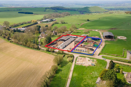
Lot 2 - Ciderhouse Farm, Sigwells, Nr. Sherborne, DT9, Nr. Sherborne, Somerset DT9 England
Added on 29/01/2026Development Land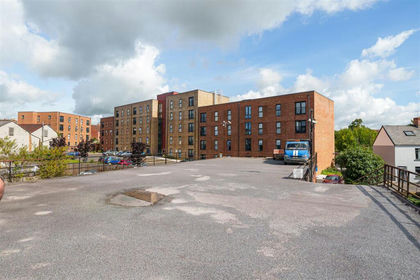
- Price
- Guide Price£310,000
Former Yeovil Snooker Club, Reckleford, Yeovil, Somerset., Yeovil, Somerset BA21 England
Added on 29/01/2026Development Land Added on 29/01/2026Self Build Plot
- Price
- Guide Price£250,000
- Size
- 0.33 acres
Cabbage Lane, Horsington, Templecombe, Horsington, Somerset BA8 England
Added on 04/07/2026Building Plot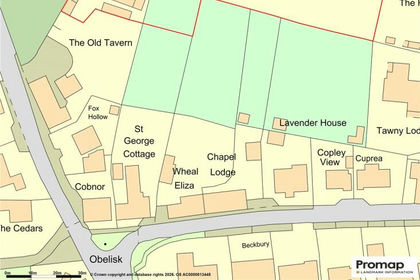
- Price
- £350,000
- Size
- 1.4 acres
Added on 08/07/2026Building Plot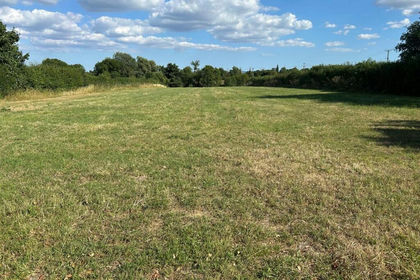
- Price
- Guide Price£350,000
- Size
- 1.5 acres
Whitechurch Lane, Yenston, Henstridge, Henstridge, Somerset BA8 England
Added on 06/05/2026Self Build Plot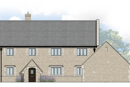
- Price
- From£235,000
Hawthorn Hill, East Lambrook, South Petherton, Kingsbury Episcopi, Somerset TA13 England
Added on 29/01/2026Self Build Plot- Price
- Guide Price£235,000
Hawthorn Hill, East Lambrook, South Petherton, Kingsbury Episcopi, Somerset TA13 England
Added on 29/01/2026Self Build Plot
- Price
- Offers in Excess of£350,000
Leighton Lane, Evercreech, BA4, Evercreech, Somerset BA4 England
Added on 29/01/2026Barn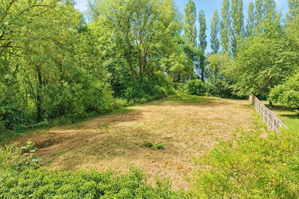
- Price
- £250,000
- Size
- 0.25 acres
Added on 17/07/2026Building Plot