Monks Hill, Emsworth, West Sussex, PO10
- Land size
- 4.2 acres
- Bedrooms
- 4
- Bathrooms
- 2
Key Features
- Vaulted Sitting Room, Family/Dining Room/Kitchen
- Spacious Reception Hall, Cloakroom, Utility Room
- Principal Bedroom Suite with Littlejohn Bathroom En-Suite
- 3 First Floor Bedrooms, Impressive Family Bathroom
- Brick & flint barn with large storage space on 2 floors, Cloakroom
- Lightly Wooded Gardens & Grounds of some 4.2 acres
Description
Surrounded by easily maintained gardens and grounds of some 4.2 acres which have been retained largely in a natural landscape with ground water fed natural ponds and oak woodland to the south. A unique conversion of a former brick works and farm buildings creating an inspirational home of enormous character, finished to the highest of standards in these idyllic rural surroundings close to the South Downs National Park.
As the name suggests, this fascinating building was originally Westbourne Brick and Tile works, and later passed into agricultural use as part of neighbouring Sawmills Farm. The interior has enormous character with vaulted ceilings and exposed timbers but in particular the former brick kiln, immediately adjacent to the 18 ft long reception hall, has been preserved as a unique feature within which a spiral staircase has been built to provide access to the bedroom accommodation. The triple aspect south facing sitting room is over 22 ft in length with vaulted ceiling lit by a high level window flooding the room with natural light. Sealed unit double glazed doors open onto a south facing terrace looking towards the woodland. An impressive fireplace is fitted with a wood burning stove. The adjacent dining/family room/kitchen is the focus of everyday living with further vaulted ceilings and a cosy fireplace with wood burning stove. This room opens directly onto the Sylvarna kitchen with its sleek, contemporary units, polished quartz worksurfaces, returns and breakfast bar. An extensive range of integrated appliances include dishwasher, induction hob with extractor, eye-level combination oven with fan assisted conventional oven beneath, Miele espresso coffee maker and Gaggenau fridge/freezer with ice maker. South facing double glazed doors open onto a beautiful area of landscaped garden designed for entertaining with a porcelain paved terrace, outside fireplace and barbeque area partially enclosed by the brick and flint walls of the original buildings and also by hornbeam and yew hedging concealing dog proof fencing.
A spiral staircase within the original brick kiln leads first to a principal bedroom suite, spacious bedroom with deep recessed walk-in wardrobe, additional bespoke fitted wardrobe and double glazed doors opening onto the sitting area looking over the gardens. An impressive bathroom en-suite, fitted by Littlejohn, has both bath and open sided shower with glazed screen, deluge style mixer and hand held spray. The split level first floor has three further bedrooms. The fourth bedroom is currently fitted as an impressive dressing room with an extensive range of matching wardrobes with automatic lighting, drawers and shelving, together with a matching dressing table with vanity surface, additional storage and mirror with integral lighting. The second Littlejohn bathroom serves the additional bedrooms.
Outside a long, stone shingled driveway passes through the surrounding grounds to a broad approach and parking area between the house and barn. The neighbouring brick and flint barn is some 60 ft long with double timber doors and pedestrian side doors. The ground floor cloakroom means this area could be used to create a home office if required or there might perhaps be potential to create an annexe subject to the necessary compliance with building regulations and planning consents. A turned staircase rises to the first floor with exposed timber frame, light and power. A car charging point is located adjacent to the parking area.
Double doors from the kitchen open onto an impressive porcelain paved terrace inlaid with brick setts which look south towards the woodland and is sheltered by the attractive brick and flint walls of the existing house and barn. An outside entertaining area includes fireplace, barbeque area, outside power points and connection points for speakers. The immediate gardens have been landscaped with pleached hornbeams and decorative borders with displays of architectural grasses, low level clipped yew topiary and flowering perennials with a palate of yellow, blue and white flowers. Neatly clipped yew and hornbeam hedging surrounds this area of the garden and also conceals dog proof fencing. Additional doors from the sitting room open onto a second raised terrace with steps down to the surrounding grounds which have been very much left as a natural landscape with two ponds fed by ground water and planted with iris and other water margin plants. Beyond this lies an area of light woodland principally oak. In all some 4.2 acres.
The property lies in countryside just to the north of the popular village of Westbourne. This is still very much a traditional village retaining a good range of local shops, several public houses, local school and a parish church. More comprehensive shopping facilities can be found in either Emsworth or Chichester. A couple of miles to the north lies the foot of the South Downs, criss-crossed with numerous bridlepaths and footpaths and providing some of the best countryside in this part of West Sussex and Hampshire. To the south, lie Chichester and Langstone Harbours, providing plenty of opportunities for sailing with clubs at Emsworth, Bosham and Hayling Island. Other recreational activities include a number of golf courses, the nearest being at Rowlands Castle, horse racing at Goodwood and bathing and windsurfing from various beaches along the south coast. Despite these idyllic rural surroundings, communications are good with the nearby A27 providing good vehicular access to various centres along the south coast including Brighton, Portsmouth and Worthing. The A3M provides good vehicle
access to London and mainline stations in both Havant and Chichester provide regular services to London Waterloo and Victoria respectively.
Map Location
Property details
- Tenure
- Freehold
- Council Tax Band
- G
- Date Posted
- 2026-07-05
Market Value Analysis
Compared with 1,739 Homes with Land listings in South East England (1+ acres).
Energy Performance Certificate
Energy Efficiency Rating
Based on UK Energy Performance Certificate standards (EU Directive 2002/91/EC)
Running costs are one side. Planning activity, flood history and ground risks for this location are in the full report.
Utilities & Restrictions
Utilities
- Electricity
- Mains
- Water
- Mains
- Heating
- Gas Heating
- Broadband
- Ask Agent
- Sewerage
- Septic Tank / Private
Rights & Restrictions
- Public Rights of Way
- Ask Agent
- Private Rights of Way
- Ask Agent
- Listed Property
- Ask Agent
- Restrictions
- Ask Agent
Listed status, conservation areas and planning constraints for this location are in the full report.
Property Features
- Accessibility
- Ask Agent
- Parking
- Garage, Driveway
- Garden
- Garden
Beyond the particulars: planning activity, flood history, heritage and ground risks, checked for this exact spot.
Connectivity
Broadband
Fastest speed available at this postcode
30 Mbps
Superfast · available to 20% of premises
Suitable for
- HD streaming
- Video calls
- Web & social
Mobile signal
Predicted 4G and 5G signal; indoor signal depends on building materials.
Ofcom Connected Nations postcode-level predictions. Speeds and signal are modelled, not measured, and vary between addresses and providers.
Signal is the easy part. Planning activity, flood history and protected designations here are in the full report.
Nearest Schools
Primary
- Westbourne Primary School884 metresOfsted: Requires improvement *
- Ages
- 4 to 11
- Pupils
- 144
- Type
- Community school
- St James Church of England Controlled Primary School1 mileNo Ofsted rating
- Ages
- 4 to 11
- Pupils
- 224
- Type
- Voluntary controlled school
- Faith
- Church of England
- Emsworth Primary School1.5 milesNo Ofsted rating
- Ages
- 4 to 11
- Pupils
- 407
- Type
- Community school
- Sharps Copse Primary and Nursery School1.6 milesNo Ofsted rating
- Ages
- 4 to 11
- Pupils
- 275
- Type
- Community school
- Rowlands Castle St John's Church of England Controlled Primary School1.6 milesOfsted report card · Jan 2026
- Ages
- 4 to 11
- Pupils
- 204
- Type
- Voluntary controlled school
- Faith
- Church of England
Secondary
- Bourne Community College1.6 milesOfsted report card · Jan 2026
- Ages
- 11 to 16
- Pupils
- 692
- Type
- Foundation school
- Havant Academy1.7 milesOfsted: Inadequate *
- Ages
- 11 to 16
- Pupils
- 505
- Type
- Academy sponsor led
- Warblington School2.1 milesOfsted report card · Feb 2026
- Ages
- 11 to 16
- Pupils
- 810
- Type
- Community school
- Park Community School3 milesNo Ofsted rating
- Ages
- 11 to 16
- Pupils
- 1,006
- Type
- Community school
- Oaklands Catholic School3.9 milesOfsted report card · Apr 2026
- Ages
- 11 to 18
- Pupils
- 1,419
- Type
- Academy converter
- Faith
- Roman Catholic
* Latest graded judgement covers quality of education only; no overall grade was issued under the 2024-25 inspection framework.
Distances are straight-line from the advertised location. Source: the national school registers (DfE, Welsh Government, Scottish Government) and Ofsted.
Schools are just the start: sold prices nearby, planning activity and any flood history are in the full report.
Amenities
Supermarket
GP surgery
Pharmacy
Hospital
Green space
Straight-line distances from the advertised location. Sources: NHS records, Geolytix supermarket locations, OS Open Greenspace and the national trails registers.
The area stacks up? Now check the location itself: planning nearby, protected designations and past flooding.
Getting Around
Nearest station
Nearest bus stop
Typical drive times
Straight-line distances from the advertised location; drive times are typical free-flow times over OpenStreetMap road data, so allow more at peak. Public transport locations from DfT NaPTAN.
Easy to reach matters. So do planning activity, flood history and ground risks: all in the full report.
Flood Risk
Environment Agency open data, checked around the advertised map pin for the listed acreage. Long-term risk counts flood defences; the planning map's flood zones do not. Provided by LandSale, not the listing agent, and not part of the agent's particulars. Risk varies across a holding, so verify before committing.
Rivers and the sea
Planning map: Flood Zone 1.
Surface water
Not at the pin: mapped about 10 metres away.
These bandings are the summary. Where this location sits on the flood maps, plus planning activity, heritage and ground risks, is in the full report.
Important notice: Information, maps and tags on this page are drawn from the advertising agent's marketing materials or generated automatically. LandSale has not verified them. Relying on these details is at your own risk, always carry out independent checks before committing to a purchase.
LandSale full disclaimer
Marketing information only - not formal particulars. The details on this website are provided for general guidance and do not constitute an offer or contract. Neither LandSale nor the advertising estate/land agent accepts responsibility for any inaccuracy.
1. Source of information
- Listing content: Core description, asking price, tenure, measurements, photographs and planning history originate from the marketing materials of the advertising estate or land agent. LandSale does not author this content and cannot guarantee its accuracy.
- Automated tags & categorisation: Property type, land-use class, acreage bands and similar labels may be applied by machine-learning models. They are intended as a helpful guide only and may not reflect the property's legal status or permitted use.
- Third-party & enriched data layers: Maps, boundary outlines, planning designations, soil reports, broadband coverage and other environmental or location-based insights are licensed from external suppliers. Such data are supplied “as is", may be incomplete or out of date and are subject to change without notice.
2. Verification required
Prospective purchasers must verify critical matters, including but not limited to planning permission, title boundaries, public rights of way, environmental constraints, acreage, services, access and VAT status, through their own inspections, specialist surveys, legal advisers and the selling agent before relying on the information or entering into any contract.
3. No warranty or liability
LandSale gives no warranty, express or implied, as to the accuracy, completeness or fitness for any particular purpose of the information displayed. LandSale shall not be liable for any loss, damage, cost or expense arising directly or indirectly from any use of or reliance on such information, save where liability may not be excluded by law.
4. Updates & feedback
If you believe any detail on this listing is inaccurate, please let us know. We will investigate and, where appropriate, update the listing or notify the agent.
© LandSale | Version 1.3 - August 2026
Listing agent
Jackson-Stops, Chichester
1 Northgate Chichester West Sussex PO19 1AT
Similar properties for sale
- Price
- Guide Price£1,999,500
- Size
- 9.62 acres
Havant Road, Hayling Island, Hampshire, PO11, Havant, Hampshire PO11 England
Added on 18/07/2026House with Land
- Price
- Guide Price£1,795,000
- Size
- 3 acres
East Ashling, Chichester, West Sussex, PO18, Funtington, West Sussex PO18 England
Added on 04/06/2026House with Land
- Price
- Offers in Excess of£2,300,000
- Size
- 8 acres
Eastland Gate, Lovedean, Waterlooville, Hampshire, PO8, Horndean, Hampshire PO8 England
Added on 29/09/2026Equestrian property
- Price
- Guide Price£2,250,000
- Size
- 2 acres
Shopwyke Road, Chichester, West Sussex, PO20, Oving, West Sussex PO20 England
Added on 29/01/2026House with Land
- Price
- Guide Price£1,500,000
- Size
- 5 acres
School Lane, Petersfield, Hampshire, GU32, Sheet, Hampshire GU32 England
Added on 07/07/2026House with Land
- Price
- Guide Price£1,800,000
- Size
- 3 acres
Crockerhill, Chichester, PO18, Boxgrove, West Sussex PO18 England
Added on 01/10/2026Farmhouse
- Price
- Offers Over£1,500,000
- Size
- 10 acres
Duckmead Lane, Liss, Hampshire, Liss, Hampshire GU33 England
Added on 29/01/2026Equestrian property
- Price
- Guide Price£1,500,000
- Size
- 2.36 acres
Added on 17/06/2026House with Land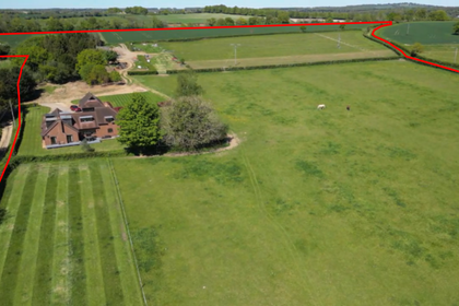
- Price
- Guide Price£1,850,000
- Size
- 13.08 acres
Added on 17/06/2026Farm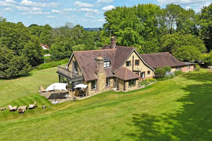
- Price
- Guide Price£1,950,000
- Size
- 2.61 acres
Lavington Park, West Sussex, East Lavington, West Sussex GU28 England
Added on 17/04/2026Country Home