Bucklands Croft, Wilstone, Hertfordshire HP23
- Bedrooms
- 3
- Bathrooms
- 2
Key Features
- Attractive home set within a private courtyard
- Three double bedrooms
- Vaulted sitting room with wood-burning stove and open-plan dining area
- Shaker-style kitchen with Belfast sink and range cooker
- Principal suite with large dressing room and en suite bathroom
- South-westerly facing rear garden of approximately 150ft
- Open views across fields beyond the post-and-rail boundary
- Detached garage and additional parking
- Walking distance to village pub, shop, cafe and surrounding countryside
- Idyllic village located just 2 miles from Tring
Description
One of a cluster of barn-style homes completed approximately 25 years ago, Swallow Barn is tucked away at the end of a pretty driveway in a quiet and well-kept courtyard. The farm shop and cafe, pub and village community-run shop are all within walking distance, while Tring and Wendover are just a short drive away, each offering direct rail services to London.
The surrounding countryside includes footpaths weaving through fields and woods, and the canal and Tring reservoirs are only minutes away.
Timber windows, doors and flooring run throughout the property, with a palette of soft, muted tones.
The front door leads to a generous hallway, where a cloakroom and understairs storage provide a practical welcome. To the left is the kitchen, shaker-style, finished in soft grey, with crisp white worktops and tiled flooring. There is a Belfast sink, alongside integrated appliances and an electric range cooker, and a breakfast bar offers a relaxing spot for informal dining with a pleasant outlook.
The heart of the home is an L-shaped sitting and dining room. A high vaulted ceiling lifts the space, while a wood-burning stove introduces warmth and focus. Newly installed aluminium French doors draw in light and open directly onto the garden.
There are two double bedrooms on the ground floor, both well-proportioned and quietly styled. They are served by a traditionally finished shower room.
A galleried landing looks down onto the hallway below and leads to the principal suite where skylights bring in soft natural light. A generous dressing room and en suite bathroom - complete with freestanding bath and walk-in rainfall shower - complete the space.
The garden is a defining feature. A terrace at the rear of the house creates a natural place for dining or evening gatherings. Beyond, the lawn stretches around 150ft, bordered by well-stocked planting that evolves through the seasons. At the far end, a post-and-rail fence marks the boundary, with open fields beyond, extending the sense of space. The garden enjoys a south-westerly aspect.
The house forms part of a small, cohesive group of barns arranged around a central courtyard. A detached garage is just across the way, with additional parking at the side of the house.
This is a house that feels settled and well judged. The proportions of the property, the warmth of the materials and the depth of the garden combine to create a home that is both easy to live in and quietly distinctive.
ANTI-MONEY LAUNDERING
In line with UK Anti Money Laundering (AML) regulations, we are legally obliged to verify the identity of all prospective purchasers once an offer has been accepted. To carry out this process, we use a trusted third-party identity verification system. A nominal fee of £48 per person (inclusive of VAT) applies for this service.
Map Location
Property details
- Tenure
- Freehold
- Council Tax Band
- E
- Date Posted
- 2026-07-01
Energy Performance Certificate
Energy Efficiency Rating
Based on UK Energy Performance Certificate standards (EU Directive 2002/91/EC)
Utilities & Restrictions
Utilities
- Electricity
- Mains
- Water
- Mains
- Heating
- Gas Central Heating
- Broadband
- Ask Agent
- Sewerage
- Mains
Rights & Restrictions
- Public Rights of Way
- Ask Agent
- Private Rights of Way
- Yes
- Listed Property
- Ask Agent
- Restrictions
- Yes
Property Features
- Accessibility
- Ask Agent
- Parking
- Garage, Driveway
- Garden
- Private Garden
Connectivity
Broadband
Fastest speed available at this postcode
1.8 Gbps
Gigabit full fibre
Suitable for
- 4K streaming on every screen
- Full-time home working
- Online gaming & big downloads
Mobile signal
Outdoor predictions; indoor signal depends on building materials.
Ofcom Connected Nations postcode-level predictions. Speeds and signal are modelled, not measured, and vary between addresses and providers.
Nearest Schools
Primary
- Marsworth Church of England Infant School1.1 milesNo Ofsted rating
- Ages
- 3 to 7
- Pupils
- 18
- Type
- Voluntary aided school
- Faith
- Church of England
- Long Marston VA Church of England Primary and Nursery School1.3 milesNo Ofsted rating
- Ages
- 3 to 11
- Pupils
- 130
- Type
- Voluntary aided school
- Faith
- Church of England
- Dundale Primary School and Nursery1.6 milesNo Ofsted rating
- Ages
- 3 to 11
- Pupils
- 182
- Type
- Academy converter
- Goldfield Infants' and Nursery School1.7 milesOfsted: Good *
- Ages
- 3 to 7
- Pupils
- 222
- Type
- Community school
- Aston Clinton School1.8 milesOfsted: Good
- Ages
- 4 to 11
- Pupils
- 402
- Type
- Community school
Secondary
- Tring School1.9 milesNo Ofsted rating
- Ages
- 11 to 18
- Pupils
- 1,599
- Type
- Academy converter
- Faith
- Church of England
- The Kingsbrook School3.8 milesOfsted: Good *
- Ages
- 11 to 18
- Pupils
- 759
- Type
- Free schools
- John Colet School4 milesNo Ofsted rating
- Ages
- 11 to 18
- Pupils
- 1,014
- Type
- Academy converter
- The Grange School4.7 milesOfsted: Good
- Ages
- 11 to 18
- Pupils
- 1,418
- Type
- Foundation school
- Aylesbury Grammar School4.8 milesOfsted: Outstanding
- Ages
- 11 to 18
- Pupils
- 1,346
- Type
- Academy converter
- Gender
- Boys
* Latest graded judgement covers quality of education only; no overall grade was issued under the 2024-25 inspection framework.
Distances are straight-line from the advertised location. Source: the national school registers (DfE, Welsh Government, Scottish Government) and Ofsted.
Amenities
Supermarket
GP surgery
Pharmacy
Hospital
Green space
Straight-line distances from the advertised location. Sources: NHS records, Geolytix supermarket locations, OS Open Greenspace and the national trails registers.
Getting Around
Nearest station
Nearest bus stop
Typical drive times
Straight-line distances from the advertised location; drive times are typical free-flow times over OpenStreetMap road data, so allow more at peak. Public transport locations from DfT NaPTAN.
Flood Risk
From Environment Agency flood map open data, checked around the advertised map pin and allowing for the listed acreage where known. This summary comes from LandSale, the advertising platform, not from the listing agent, and is not part of the agent's particulars. Risk can vary across a single holding, so verify anything critical through your own searches before committing.
Rivers and the sea
Surface water
The detail behind these bandings, including exact zones and annual chances, any recorded past flooding, plus planning, heritage, nature and ground checks, is in the .
Important notice: Information, maps and tags on this page are supplied by the advertising agent or generated automatically. LandSale has not verified them. Relying on these details is at your own risk, always carry out independent checks before committing to a purchase.
LandSale full disclaimer
Marketing information only - not formal particulars. The details on this website are provided for general guidance and do not constitute an offer or contract. Neither LandSale nor the advertising estate/land agent accepts responsibility for any inaccuracy.
1. Source of information
- Agent-supplied content: Core description, asking price, tenure, measurements, photographs and planning history are uploaded by the appointed agent, who remains solely responsible for their accuracy.
- Automated tags & categorisation: Property type, land-use class, acreage bands and similar labels may be applied by machine-learning models. They are intended as a helpful guide only and may not reflect the property's legal status or permitted use.
- Third-party & enriched data layers: Maps, boundary outlines, planning designations, soil reports, broadband coverage and other environmental or location-based insights are licensed from external suppliers. Such data are supplied “as is", may be incomplete or out of date and are subject to change without notice.
2. Verification required
Prospective purchasers must verify critical matters, including but not limited to planning permission, title boundaries, public rights of way, environmental constraints, acreage, services, access and VAT status, through their own inspections, specialist surveys, legal advisers and the selling agent before relying on the information or entering into any contract.
3. No warranty or liability
LandSale gives no warranty, express or implied, as to the accuracy, completeness or fitness for any particular purpose of the information displayed. LandSale shall not be liable for any loss, damage, cost or expense arising directly or indirectly from any use of or reliance on such information, save where liability may not be excluded by law.
4. Updates & feedback
If you believe any detail on this listing is inaccurate, please let us know. We will investigate and, where appropriate, update the listing or notify the agent.
© LandSale | Version 1.2 - January 2026
Listing agent
Nash, Hertfordshire & Buckinghamshire
35 High Street Tring Hertfordshire HP23 5AA
Contact Nash, Hertfordshire & Buckinghamshire
35 High Street Tring Hertfordshire HP23 5AA
View agent profileSimilar properties for sale
 Added on 22/05/2026Barn Conversion
- Price
- Offers in Excess of£750,000
- Size
- 0.4 acres
Church Lane, Cheddington, Leighton Buzzard, Cheddington, Buckinghamshire LU7 England
Added on 24/06/2026Barn Conversion
- Price
- Guide Price£695,000
Added on 26/04/2026Barn Conversion
- Price
- £625,000
- Size
- 5 acres
Cane End Farm, Hulcott, Aylesbury, Buckinghamshire, HP22, Hulcott, Buckinghamshire HP22 England
Added on 01/08/2026Conversion Land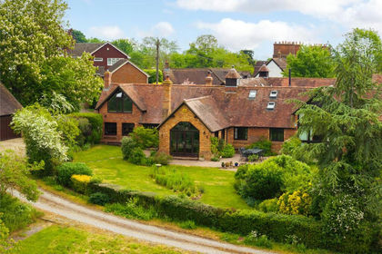
- Price
- £1,000,000
- Size
- 2 acres
Added on 15/05/2026Barn Conversion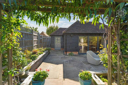
- Price
- Guide Price£899,000
- Size
- 3 acres
Added on 30/04/2026Barn Conversion
- Price
- Guide Price£800,000
Site with Permission - Hale Road Wendover, Wendover, Buckinghamshire HP22 England
Added on 14/08/2026Building Plot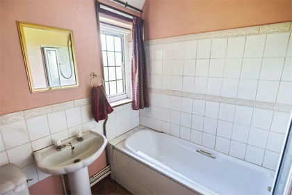
- Price
- Offers in Region of£1,000,000
- Size
- 5.33 acres
Norcott Hill, Northchurch, Hertfordshire., Northchurch, Hertfordshire HP4 England
Added on 07/03/2026Cottage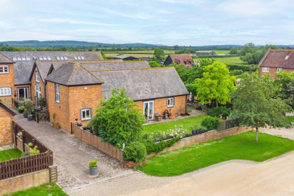
- Price
- Guide Price£775,000
The Shire House, Rowden Farm Barns, Mentmore, Mentmore, Buckinghamshire LU7 England
Added on 24/06/2026Barn Conversion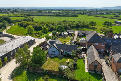
- Price
- Offers in Excess of£1,000,000
Ledburn, Leighton Buzzard, Mentmore, Buckinghamshire LU7 England
Added on 13/03/2026Barn Conversion