Witton Le Wear, Bishop Auckland, Durham, DL14
- Land size
- 118.28 acres
- Bedrooms
- 3
- Bathrooms
- 1
Description
Blakeley Hall Farm comprises an outstanding, well maintained grassland farm extending as a whole to approximately 118.28 acres (47.87 hectares) in a ring fenced unit along with a detached, double fronted farmhouse and a range of traditional stone and modern farm buildings. The farm is readily accessed from the main road with a well maintained, private tarmac driveway leading to the property.
• Well maintained grassland farm
• Equipped unit in a ring fence
• Far reaching views of Weardale
• South facing, well drained, productive land
• Outstanding range of traditional farm buildings
• Attractive, family home
DESCRIPTION
Blakeley Hall Farm comprises an outstanding well maintained grassland farm extending as a whole to approximately 118.28 acres (47.87 hectares) in a ring fenced unit. The steading is centrally located providing a detached farmhouse with spacious living accommodation and private garden, along with a beautiful range of traditional stone buildings and modern steel framed general storage sheds.
LOCATION
Blakeley Hall Farm is located to the north east of the sought after village of Witton le Wear in County Durham, as shown circled red on the location plan. The farmhouse has a commanding position with breathtaking views.
The farm is 1 mile east of the A68 which provides good road links to the A1(M) at Bradbury (12 miles to the east), the A69 at Corbridge (24 miles to the north) and the A66 at Scotch Corner (20 miles to the south). The property is located near to Hamsterley Forest and other local attractions including Witton Castle, Raby Castle, Auckland Castle, the Weardale Railway and the River Wear.
FARMHOUSE
The farmhouse is an attractive, two storey, stone built house under a pitched slate roof. Downstairs there is a kitchen, dining room, sitting room, utility room and shower room. Upstairs there are three spacious double bedrooms along with a family bathroom.
Attached to the farmhouse there is a single storey garage building and garden room. To the rear there is a large, tarmac parking area. To the front of the farmhouse there is an attractive, south facing, lawned garden with stunning views towards Witton Castle and beyond.
GROUND FLOOR
KITCHEN
15'8" x 15'11" (4.78m x 4.85m) With fitted units, lino flooring and exposed wooden beams.
DINING ROOM
15'1" x 13'9" (4.6m x 4.2m) Adjoining the kitchen, with carpet floor and feature fireplace. Wooden patio doors overlooking the lawned garden.
SITTING ROOM
16'6" x 13'9" (5.03m x 4.2m) Carpet floor with feature fireplace and wooden patio doors overlooking the lawned garden.
REAR PORCH
Small porch area to the rear of the property leading to the lawned garden.
SHOWER ROOM
6' x 7'4" (1.83m x 2.24m) With shower, WC and wash hand basin.
UTILITY ROOM
10'1" x 7'4" (3.07m x 2.24m) Tiled flooring.
UPSTAIRS
BEDROOM 1
16'6" x 13'9" (5.03m x 4.2m) With carpet floor, fitted wardrobe and drawer units. Aspect to the rear with views to Witton Castle.
LANDING
Large carpeted landing area.
BEDROOM 2
15'1" x 13'9" (4.6m x 4.2m) With carpet floor, built in wardrobe and aspect to the rear.
BATHROOM
12'1" x 6'9" (3.68m x 2.06m) Family bathroom with fitted bathtub, WC, wash hand basin and storage cupboard, carpet flooring.
BEDROOM 3
15'8" x 15'11" (4.78m x 4.85m) With carpet floor and aspect to the west of the property.
PLANNING CONSENT - FARMHOUSE
The farmhouse has previously had planning consent for an extension which was granted in 2009, Durham County Council Planning Reference 3/2009/0186. The planning consent approved the conversion of the adjacent building to provide a larger kitchen, utility and garden room and an additional bedroom upstairs.
FARM BUILDINGS
There is a range of useful traditional and modern farm buildings with scope to be used for a variety of purposes, as described below:
1. Modern steel portal frame building (9.14 m x 22.86 m)
2. Traditional stone building with first floor granary and external stone staircase (5.35 m x 22.86 m)
3. Traditional stone building (5.75 m x 22.86 m)
4. Traditional stone building (7.61 m x 14.71 m)
5. Traditional stone building (7.61 m x 14.71 m)
6. Allotment House - a traditional stone field barn with direct access to the public highway which could be developed in the future, subject to obtaining the necessary consents and permissions.
Planning consent has previously been granted for the conversion of the farm buildings into four dwelling houses, along with the construction of a garage and storage lock. The planning permission was granted by Durham County Council under reference 3/2013/0133.
THE LAND
The land extends to 116.81 acres (47.27 hectares) and is put down to permanent grassland. The land has previously been in an arable rotation. The land is in good heart and condition, with boundaries of fences and hedges and piped water supply to troughs in fields.
The land is south facing and freely draining, it is Grade 3 land of the Brickfield 3 soil type which is a mixture of loam and clay soil extending south towards the River Wear.
TENURE
The farm is freehold. Part of the grassland is subject to a short term letting agreement and the balance of the property is sold with vacant possession. Further details are available on request from the selling agents.
ACCESS
Access is taken directly from the public highway along the tarmac farm drive.
ENVIRONMENTAL SCHEMES
The land is not included in any environmental schemes at present.
PUBLIC RIGHTS OF WAY
The farm is crossed by DCC public footpaths 184 and 119. A plan can be provided to show the location of the footpaths.
EASEMENTS AND WAYLEAVES
The farm is sold subject to and with the benefit of all rights of way, drainage, water courses, light and other easements, quasi or reputed easements and rights of adjoining owners (if any) affecting the same and all matters registerable by any competent authority pursuant to statute.
In particular the farm is crossed by a low voltage electricity line on wayleave to Northern Powergrid and a gas pipe on an easement.
SERVICES
The farm is served by mains electricity and mains water connections. The farmhouse has oil fired central heating and sewerage is to a septic tank.
COUNCIL TAX
The farmhouse is in Council Tax Band F.
EPC
The current Energy Efficiency Rating is 38 (F), with the potential to be 84 (B).
MINERAL RIGHTS
Mineral rights are not included in the sale and are held by a third party.
SPORTING RIGHTS
Sporting rights are in hand and included in the sale.
ACREAGES
The gross acreages have been assessed in accordance with Ordnance Survey data and interested parties should satisfy themselves in this regard.
BOUNDARY LIABILITIES
Boundary liabilities, to the best of the vendor's knowledge, are shown by means of inward facing T marks on the plan.
OVERAGE
The property is sold subject to overage provisions which will require the purchaser to account to the sellers and their successors in title for 30% of any uplift in value on the grant of planning permission for any non agricultural or non equestrian use for a period of 60 years.
DATA PACK
A data pack is available to interested parties, comprising the following:
- Energy Performance Certificate
- Title Documentation
- Planning Documents
- Extract of DCC Definitive Map
LEGAL FORMALITIES
Exchange of contracts shall take place as soon as possible and, in any event, no later than the expiry of 8 weeks from instructing solicitors, with completion 14 days thereafter.
COSTS
Each party is to bear their own costs.
LOCAL AUTHORITY
Durham County Council .
VIEWING
Viewing is strictly by appointment with the sole selling agent. Please contact the Sedgefield Office on or lily. or joanne. .
ANTI MONEY LAUNDERING REGULATIONS
The Purchaser will be required to provide proof of identification to comply with Anti Money Laundering Regulations in the form of a copy of the Purchaser’s passport, together with a copy of the Purchaser’s driving licence or a recent utility bill as proof of residence.
NOTES
Particulars prepared September 2025
Photographs taken September 2025
Map Location
Property details
- Tenure
- Freehold
- Council Tax Band
- F
- Date Posted
- 2026-06-18
Market Value Analysis
Compared with 10 Farms & Smallholdings listings in North East England (100+ acres).
Energy Performance Certificate
Energy Efficiency Rating
Based on UK Energy Performance Certificate standards (EU Directive 2002/91/EC)
Running costs are one side. Planning activity, flood history and ground risks for this location are in the full report.
Utilities & Restrictions
Utilities
- Electricity
- Mains
- Water
- Mains
- Heating
- Oil Heating
- Broadband
- Ask Agent
- Sewerage
- Septic Tank / Private
Rights & Restrictions
- Public Rights of Way
- Yes
- Private Rights of Way
- Ask Agent
- Listed Property
- Ask Agent
- Restrictions
- Ask Agent
Listed status, conservation areas and planning constraints for this location are in the full report.
Property Features
- Accessibility
- Ask Agent
- Parking
- Private Parking
- Garden
- Garden
Beyond the particulars: planning activity, flood history, heritage and ground risks, checked for this exact spot.
Connectivity
Broadband
Fastest speed available at this postcode
18 Mbps
Standard (10-30 Mbps)
Suitable for
- Web & social
- Music streaming
- Standard video calls
Mobile signal
Outdoor predictions; indoor signal depends on building materials.
Ofcom Connected Nations postcode-level predictions. Speeds and signal are modelled, not measured, and vary between addresses and providers.
Signal is the easy part. Planning activity, flood history and protected designations here are in the full report.
Nearest Schools
Primary
- Witton-le-Wear Primary School915 metresOfsted: Outstanding *
- Ages
- 2 to 11
- Pupils
- 114
- Type
- Academy converter
- Howden-le-Wear Primary School0.9 milesOfsted: Good *
- Ages
- 2 to 11
- Pupils
- 179
- Type
- Academy converter
- St Chad's Catholic Primary School, Witton Park2 milesOfsted: Good
- Ages
- 3 to 11
- Pupils
- 57
- Type
- Academy converter
- Faith
- Catholic
- Crook Primary School2 milesNo Ofsted rating
- Ages
- 2 to 11
- Pupils
- 342
- Type
- Community school
- Hartside Primary Academy2.4 milesNo Ofsted rating
- Ages
- 2 to 11
- Pupils
- 241
- Type
- Academy converter
Secondary
- Parkside Academy3.4 milesOfsted: Good
- Ages
- 11 to 16
- Pupils
- 833
- Type
- Academy converter
- Bishop Barrington Academy3.8 milesOfsted: Good
- Ages
- 11 to 16
- Pupils
- 599
- Type
- Academy converter
- St John's Catholic School & Sixth Form College3.8 milesNo Ofsted rating
- Ages
- 11 to 18
- Pupils
- 1,229
- Type
- Academy converter
- Faith
- Roman Catholic
- King James I Academy Bishop Auckland4.2 milesOfsted report card · Mar 2026
- Ages
- 11 to 18
- Pupils
- 936
- Type
- Academy converter
- Wolsingham School6 milesNo Ofsted rating
- Ages
- 11 to 16
- Pupils
- 774
- Type
- Academy converter
* Latest graded judgement covers quality of education only; no overall grade was issued under the 2024-25 inspection framework.
Distances are straight-line from the advertised location. Source: the national school registers (DfE, Welsh Government, Scottish Government) and Ofsted.
Schools are just the start: sold prices nearby, planning activity and any flood history are in the full report.
Amenities
Supermarket
GP surgery
Pharmacy
Hospital
Green space
Straight-line distances from the advertised location. Sources: NHS records, Geolytix supermarket locations, OS Open Greenspace and the national trails registers.
The area stacks up? Now check the location itself: planning nearby, protected designations and past flooding.
Getting Around
Nearest station
Nearest bus stop
Typical drive times
Straight-line distances from the advertised location; drive times are typical free-flow times over OpenStreetMap road data, so allow more at peak. Public transport locations from DfT NaPTAN.
Easy to reach matters. So do planning activity, flood history and ground risks: all in the full report.
Flood Risk
From Environment Agency flood map open data, checked around the advertised map pin and allowing for the listed acreage where known. This summary comes from LandSale, the advertising platform, not from the listing agent, and is not part of the agent's particulars. Risk can vary across a single holding, so verify anything critical through your own searches before committing.
Rivers and the sea
Surface water
Mapped within the area searched, not at the advertised map pin itself.
These bandings are the summary. Where this location sits on the flood maps, plus planning activity, heritage and ground risks, is in the full report.
Important notice: Information, maps and tags on this page are drawn from the advertising agent's marketing materials or generated automatically. LandSale has not verified them. Relying on these details is at your own risk, always carry out independent checks before committing to a purchase.
LandSale full disclaimer
Marketing information only - not formal particulars. The details on this website are provided for general guidance and do not constitute an offer or contract. Neither LandSale nor the advertising estate/land agent accepts responsibility for any inaccuracy.
1. Source of information
- Listing content: Core description, asking price, tenure, measurements, photographs and planning history originate from the marketing materials of the advertising estate or land agent. LandSale does not author this content and cannot guarantee its accuracy.
- Automated tags & categorisation: Property type, land-use class, acreage bands and similar labels may be applied by machine-learning models. They are intended as a helpful guide only and may not reflect the property's legal status or permitted use.
- Third-party & enriched data layers: Maps, boundary outlines, planning designations, soil reports, broadband coverage and other environmental or location-based insights are licensed from external suppliers. Such data are supplied “as is", may be incomplete or out of date and are subject to change without notice.
2. Verification required
Prospective purchasers must verify critical matters, including but not limited to planning permission, title boundaries, public rights of way, environmental constraints, acreage, services, access and VAT status, through their own inspections, specialist surveys, legal advisers and the selling agent before relying on the information or entering into any contract.
3. No warranty or liability
LandSale gives no warranty, express or implied, as to the accuracy, completeness or fitness for any particular purpose of the information displayed. LandSale shall not be liable for any loss, damage, cost or expense arising directly or indirectly from any use of or reliance on such information, save where liability may not be excluded by law.
4. Updates & feedback
If you believe any detail on this listing is inaccurate, please let us know. We will investigate and, where appropriate, update the listing or notify the agent.
© LandSale | Version 1.3 - August 2026
Listing agent
youngsRPS, Northallerton
80-81 High Street, Northallerton, DL7 8EG
Similar properties for sale
- Price
- £1,800,000
- Size
- 129.28 acres
Whiley Hill Farm, Coatham Mundeville, Darlington, Coatham Mundeville, Darlington DL3 England
Added on 14/04/2026Farm
- Price
- Offers Over£2,000,000
- Size
- 262.28 acres
Middle Horsleyhope Farm, Consett, Blaydon and Consett, County Durham DH8 England
Added on 30/05/2026Farm
- Price
- Guide Price£1,400,000
- Size
- 75.07 acres
Dovecote Farm, Elwick, Hartlepool, Elwick, Hartlepool TS27 England
Added on 04/07/2026Farm
- Price
- £1,495,000
- Size
- 77.11 acres
Syke Side Farm, Soulby, Kirkby Stephen, Cumbria, CA17, Soulby, Westmorland and Furness CA17 England
Added on 29/01/2026Farm
- Price
- Offers Over£1,400,000
- Size
- 81 acres
Added on 29/01/2026Farm
- Price
- Offers in Excess of£1,400,000
- Size
- 123.9 acres
Added on 15/08/2026Farm
- Price
- Offers Over£1,650,000
- Size
- 250.68 acres
Sunny Rigg Farm, Haltwhistle, Haltwhistle, Northumberland NE49 England
Added on 04/07/2026Farm
- Price
- Guide Price£1,800,000
- Size
- 291.83 acres
Added on 02/07/2026Farm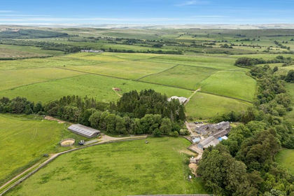
- Price
- Guide Price£1,800,000
- Size
- 291.83 acres
Linacres Farm, Wark, Hexham, Northumberland, NE48, Wark, Northumberland NE48 England
Added on 02/07/2026Farm