Lower Sandy Down, Boldre, Lymington, Hampshire
- Land size
- 18 acres
- Bedrooms
- 5
- Bathrooms
- 4
Key Features
- A remarkable countryside residence offering complete tranquillity
- East and west wings comprising five bedrooms
- Living/dining room & kitchen/breakfast room
- Fabulous drawing room, study, utility room & larder/store
- En suite dressing room & en suite to the main bedroom
- Two further en suites & family bathroom
- Stunning park-like grounds of approximately 18 acres
- Swimming pool, summer house, stream, two lakes & woodland
- Four car garage & separate oak barn with water & electricity
- Just two miles from the sailing town of Lymington
Description
Set within approximately 18 acres of breath-taking park-like grounds, this remarkable split-level residence offers a rare combination of privacy, tranquillity, and natural beauty. Designed by a leading architect, the home blends harmoniously with its idyllic surroundings, which include mature woodland, two serene lakes, a meandering stream, and a private swimming pool.
The residence itself is thoughtfully arranged into east and west wings, offering five well-appointed bedrooms and an abundance of versatile living space. Highlights include a generous living/dining area, a magnificent drawing room with expansive views, and a layout ideal for both family life and entertaining.
Located just outside the renowned sailing town of Lymington, the property enjoys a secluded, protected position within the New Forest National Park, where wildlife thrives - from deer and birds to waterfowl frequenting the lakes.
This is a truly rare opportunity to acquire a distinctive country home in one of the South Coast's most desirable and unspoilt locations.
STEP INSIDE
The double front door opens into the naturally lit lobby with a second pair of double doors opening into the reception hall where there is a useful cloaks cupboard, and two staircases leading to the east and west wings. Directly ahead, a further pair of glazed double doors open into the living and dining room which overlooks the garden and woods beyond and has an open fireplace with brick facings. The kitchen/breakfast room, which can be accessed from both the dining room and the hall, faces south and east and has a glazed door opening out to the patio and garden. The Mark Wilkinson kitchen is fitted with a range of floor and wall mounted limed oak units incorporating Miele integrated appliances including a double oven, ceramic hob and microwave as well as a ceramic one-and-a-half bowl sink. Adjacent to the kitchen, three steps lead down to the rear porch and further steps lead to the utility area which is fitted with a range of units and has space/plumbing for a washing machine and tumble dryer. There is also a cloakroom, and a door which gives access to the double garage. From the utility, steps lead down to the lower basement where the gas fired boiler, which provides domestic hot water and central heating, is situated, as well as the hot water tank/control and irrigation controls for the automatic watering of the garden, and a useful shelved larder/food store.
Back in the reception hall, stairs lead to the east wing where the main and second bedrooms are situated, and on the landing there are a range of cupboards incorporating an airing cupboard. The main bedroom enjoys fabulous views of the woods and has an en suite dressing room including an extensive range of wardrobes and a separate en suite bathroom comprising a bath, shower enclosure, WC and vanity unit. Bedroom two is currently used as a sewing room and has a range of cupboards including a vanity unit, and there is also a separate cloakroom on this floor.
From the reception hall, stairs then lead to the west wing landing where there are three further bedrooms; bedroom three enjoys a dual aspect overlooking the grounds and has an en suite shower room as well as fitted wardrobes. Bedroom four also has a wardrobe and an en suite shower room, and bedroom five is a good sized double. There is a family bathroom, a separate WC and a range of fitted cupboards on the landing.
Further stairs lead from the reception hall down to the large drawing room which has a corner fireplace with a wood burning stove and doors opening out onto the patio and garden. From this room, there is a study/office with further patio doors to the garden, as well as further stairs leading to the lower ground floor.
THE GARDENS & GROUNDS
The gardens and grounds that surround the property are of park-like status with two lakes being stream fed and running through the centre of the land with woodland borders offering complete seclusion and privacy with a footpath meandering through the woods with a pleasant riverside walk. There is a useful double oak-framed garage with a car port. Leading off from the drawing room is a lovely paved terrace with a tiled swimming pool and a summer house. The grounds afford complete privacy, there is outside lighting which illuminates the trees and the driveway.
DIRECTIONS
From our office in the High Street proceed up into St Thomas Street joining the one way system in the right hand lane and continuing past Waitrose. Pass through two sets of traffic lights and straight over the three mini roundabouts, then turn right into Boldre Lane. Continue along to the end, and at the junction adjacent to the Red Lion, turn left and then right into Royden Lane. Proceed along taking the next turning left which is Lower Sandy Down, and the entrance to the property will be seen along on the left hand side.
SERVICES
Mains water, electricity and gas are connected to the property. Drainage is to a private system. Fibre broadband is connected to the property with speeds up to 900mbps.
TENURE
Freehold
TAX BAND
H (£4,429.70 per annum - 2025/2026)
EPC RATING
E
Map Location
Property details
- Tenure
- Freehold
- Council Tax Band
- Ask Agent
- Date Posted
- 2026-06-16
Market Value Analysis
Compared with 197 Homes with Land listings in South East England (10+ acres).
Utilities & Restrictions
Utilities
- Electricity
- Ask Agent
- Water
- Ask Agent
- Heating
- Ask Agent
- Broadband
- Ask Agent
- Sewerage
- Ask Agent
Rights & Restrictions
- Public Rights of Way
- Ask Agent
- Private Rights of Way
- Ask Agent
- Listed Property
- Ask Agent
- Restrictions
- Ask Agent
Property Features
- Accessibility
- Ask Agent
- Parking
- Parking Available
- Garden
- Garden
Connectivity
Broadband
Fastest speed available at this postcode
1.8 Gbps
Gigabit full fibre
Suitable for
- 4K streaming on every screen
- Full-time home working
- Online gaming & big downloads
Mobile signal
Outdoor predictions; indoor signal depends on building materials.
Ofcom Connected Nations postcode-level predictions. Speeds and signal are modelled, not measured, and vary between addresses and providers.
Nearest Schools
Primary
- William Gilpin Church of England Primary School0.9 milesOfsted report card · Mar 2026
- Ages
- 4 to 11
- Pupils
- 74
- Type
- Voluntary aided school
- Faith
- Church of England
- Lymington Junior School2 milesNo Ofsted rating
- Ages
- 7 to 11
- Pupils
- 250
- Type
- Community school
- Brockenhurst Church of England Primary School & Pre-School2.1 milesNo Ofsted rating
- Ages
- 2 to 11
- Pupils
- 231
- Type
- Voluntary controlled school
- Faith
- Church of England
- Lymington Church of England Infant School2.1 milesOfsted: Outstanding
- Ages
- 5 to 7
- Pupils
- 180
- Type
- Voluntary aided school
- Faith
- Church of England
- Our Lady and St Joseph Catholic Primary School - the Learning Federation Partnership of Schools2.3 milesOfsted: Outstanding
- Ages
- 4 to 11
- Pupils
- 104
- Type
- Voluntary aided school
- Faith
- Roman Catholic
Secondary
- Priestlands School2.6 milesNo Ofsted rating
- Ages
- 11 to 16
- Pupils
- 1,205
- Type
- Academy converter
- The Arnewood School5.6 milesOfsted report card · Mar 2026
- Ages
- 11 to 18
- Pupils
- 839
- Type
- Academy converter
- Applemore College7.3 milesOfsted: Good *
- Ages
- 11 to 16
- Pupils
- 478
- Type
- Foundation school
- Noadswood School7.6 milesNo Ofsted rating
- Ages
- 11 to 16
- Pupils
- 1,102
- Type
- Academy converter
- Lift New Forest7.9 milesOfsted: Good
- Ages
- 11 to 16
- Pupils
- 504
- Type
- Academy sponsor led
* Latest graded judgement covers quality of education only; no overall grade was issued under the 2024-25 inspection framework.
Distances are straight-line from the advertised location. Source: the national school registers (DfE, Welsh Government, Scottish Government) and Ofsted.
Amenities
Supermarket
GP surgery
Pharmacy
Hospital
Straight-line distances from the advertised location. Sources: NHS records, Geolytix supermarket locations, OS Open Greenspace and the national trails registers.
Getting Around
Nearest station
Nearest bus stop
Typical drive times
Straight-line distances from the advertised location; drive times are typical free-flow times over OpenStreetMap road data, so allow more at peak. Public transport locations from DfT NaPTAN.
Flood Risk
From Environment Agency flood map open data, checked around the advertised map pin and allowing for the listed acreage where known. This summary comes from LandSale, the advertising platform, not from the listing agent, and is not part of the agent's particulars. Risk can vary across a single holding, so verify anything critical through your own searches before committing.
Rivers and the sea
Mapped within the area searched, not at the advertised map pin itself.
Surface water
Mapped within the area searched, not at the advertised map pin itself.
The detail behind these bandings, including exact zones and annual chances, any recorded past flooding, plus planning, heritage, nature and ground checks, is in the .
Important notice: Information, maps and tags on this page are supplied by the advertising agent or generated automatically. LandSale has not verified them. Relying on these details is at your own risk, always carry out independent checks before committing to a purchase.
LandSale full disclaimer
Marketing information only - not formal particulars. The details on this website are provided for general guidance and do not constitute an offer or contract. Neither LandSale nor the advertising estate/land agent accepts responsibility for any inaccuracy.
1. Source of information
- Agent-supplied content: Core description, asking price, tenure, measurements, photographs and planning history are uploaded by the appointed agent, who remains solely responsible for their accuracy.
- Automated tags & categorisation: Property type, land-use class, acreage bands and similar labels may be applied by machine-learning models. They are intended as a helpful guide only and may not reflect the property's legal status or permitted use.
- Third-party & enriched data layers: Maps, boundary outlines, planning designations, soil reports, broadband coverage and other environmental or location-based insights are licensed from external suppliers. Such data are supplied “as is", may be incomplete or out of date and are subject to change without notice.
2. Verification required
Prospective purchasers must verify critical matters, including but not limited to planning permission, title boundaries, public rights of way, environmental constraints, acreage, services, access and VAT status, through their own inspections, specialist surveys, legal advisers and the selling agent before relying on the information or entering into any contract.
3. No warranty or liability
LandSale gives no warranty, express or implied, as to the accuracy, completeness or fitness for any particular purpose of the information displayed. LandSale shall not be liable for any loss, damage, cost or expense arising directly or indirectly from any use of or reliance on such information, save where liability may not be excluded by law.
4. Updates & feedback
If you believe any detail on this listing is inaccurate, please let us know. We will investigate and, where appropriate, update the listing or notify the agent.
© LandSale | Version 1.2 - January 2026
Listing agent
Caldwells Estate Agents, Lymington
69 High Street, Lymington, SO41 9AL
Similar properties for sale
- Price
- Guide Price£3,000,000
- Size
- 24 acres
Highwood, Ringwood, Ellingham, Harbridge and Ibsley, Hampshire BH24 England
Added on 04/06/2026Country Home
- Price
- £3,000,000
- Size
- 12.5 acres
Vernon Hill, Bishops Waltham, SO32, Bishops Waltham, Hampshire SO32 England
Added on 29/07/2026House with Land
- Price
- Guide Price£4,500,000
- Size
- 52 acres
Added on 07/07/2026Country Estate
- Price
- Guide Price£3,370,000
- Size
- 89.12 acres
Added on 09/07/2026Country Estate
- Price
- £3,000,000
- Size
- 10 acres
Added on 01/05/2026Country Home
- Price
- Guide Price£4,500,000
- Size
- 16 acres
Durford Wood, Petersfield, Hampshire, GU31, Rogate, West Sussex GU31 England
Added on 22/06/2026Country Home
- Price
- £3,250,000
- Size
- 10.4 acres
Durford Wood, Petersfield, West Sussex, Rogate, West Sussex GU31 England
Added on 17/06/2026Country Estate
- Price
- Offers Over£3,250,000
- Size
- 10.4 acres
Durford Wood, Petersfield, GU31, Rogate, West Sussex GU31 England
Added on 29/01/2026Country Home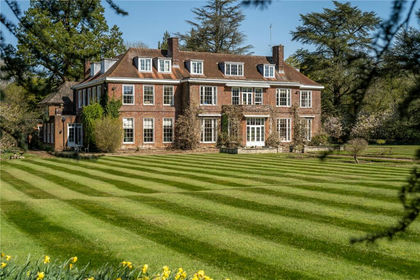
- Price
- Guide Price£3,500,000
- Size
- 29 acres
Sheet, Petersfield, Hampshire, GU31, Liss, Hampshire GU31 England
Added on 16/04/2026Country Home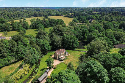
- Price
- Guide Price£2,900,000
- Size
- 10 acres
Tunbridge Lane, Bramshott, Liphook, Hampshire, GU30, Bramshott and Liphook, Hampshire GU30 England
Added on 16/06/2026Mill Conversion