5 Stable Mews, Dalefords Lane Sandiway CW8
- Land size
- 0.25 acres
- Bedrooms
- 2
- Bathrooms
- 2
Key Features
- Hugely appealing and unique single storey detached dwelling
- Two bedrooms, two bathrooms
- Bespoke breakfast kitchen of excellent quality with mezzanine level
- Large living room of excellent size with bi fold doors
- Very unusual and attractive plot, total size circa 0.25 acre
- Detached quadruple bay stable block with tack room, 673 sq ft
- Further storage building of circa 231 square feet
- Gated driveway, landscaped gardens and veg patch
- Gated development on the edge of Sandiway village
- Viewing essential, rare buying opportunity, no chain
Description
Comment from Robert Reed of Gascoigne Halman
Nestled on the rural fringe of Sandiway Village, this striking individual stable conversion forms one part of an exclusive and private development known as Stable Mews. Each property enjoys its own private driveway and garden and the entire development is secure and private, with an electrically operated security gate at the front that is managed by a intercom entry system. It is a lovely setting and as a residential concept, very rarely found.
The single storey dwelling is a conversion that has been created using very high grade building materials which provide an aesthetically pleasing external appearance and combine internally with tasteful and refined contemporary finish. It extends to just over a thousand square feet and provides a really unusual yet highly practical and flexible layout. Quality is embedded throughout and this is a home that instantly impresses and by virtue of being single storey, provides long term peace of mind. There is underfloor heating throughout.
So the residence itself is a real one off but as the saying goes, you aint seen nothing yet! The plot is circa a quarter of an acre in total and the size of the residence is nearly matched by the size of the outbuildings, which comprise a stable block and stores. So, if you want storage space galore, this will likely be your dream! The plot also has ample parking and turning space, a yard area, veg patch and an expanse of lawn with mature planting. It is about as varied a plot as you are ever likely to encounter.
There is no chain here and I anticipate significant market interest.
For a personal description of the property or to arrange a viewing, please contact myself or the Gascoigne Halman Tarporley office.
Accommodation and dimensions
As detailed on floorplan.
Location
This is a sought after semi rural area, situated between Hartford and Tarporley. Sandiway boasts some lovely surrounding countryside, with the Whitegate Way and River Weaver close by for those who enjoy walking, cycling and horse riding.
Sandiway and Cuddington between them offer a host of amenities and De Fine is very close at hand.
Hartford village is just over five minutes drive away and has a number of shops and schools including the highly regarded Grange Junior and Senior School. Hartford also boasts a main line railway station to Liverpool and London Euston (with regular services taking about two hours).
There are also several golf clubs within short driving distance of the property, plus Vale Royal Abbey golf course within the village. Manchester and Liverpool International Airports can be commuted to in 40 minutes whilst railway links are offered at nearby railway stations including, Cuddington, Acton Bridge, Chester and Crewe. MediaCity UK, Salford can be reached in under 50 minutes drive.
The area as a whole has access to glorious countryside and places of significant interest that include ancient castles, boating facilities on nearby canals and the outstanding Sandstone Ridges of Cheshire.
Whilst the area is renowned for its outstanding natural beauty, the house also offers an excellent base for the business traveller. In terms of road links, there are extensive connections to the M56, M6 and M53. The A49, A51 and A55 all link to key areas of commerce and interest. Whitegate is particularly convenient for the A556 Manchester to Chester link road.
Directions
From our office in the centre of Tarporley take a right turn. Upon reaching the roundabout take the third exit onto the A49. Proceed up the A49 through the village of Cotebrook and after passing the Garden Centre on the left hand side you will come to a crossroads. At the crossroads take the right turn onto the A54. Proceed along, passing the Shrewsbury Arms Public House on your left side and at the next crossroads take a left hand turn onto Shay Lane. Proceed along Shay Lane for a couple of miles until reaching a further set of crossroads. Take a left turn and this becomes Dalefords Lane. The property will be located on the right hand side shortly before a set of traffic lights.
Tenure / Services / Viewing
TENURE We believe the property is freehold tenure.
SERVICES We understand that mains water, and electricity are connected. The heating system is electric and the drainage private.
VIEWING Viewing by appointment with the Agents Tarporley office.
WANT TO MOVE BUT NEED TO SELL?
If you are interested in this property but need to sell your own home in Cheshire, South Manchester or the Peak District, Gascoigne Halman can provide a free, no obligation market appraisal and valuation of your own home. We are proud to be the leading estate agent in the area, with a network of twenty three offices - full contact details can be located on our website. Robert Reed is the manager of the Tarporley office.
The Tarporley team consists of Robert, Pamela, Oliver, Sally, Tresa, Sam, Clive, Lydia and Yvonne - we pride ourselves on being not just professional and efficient but also warm and welcoming. If you are in the village and fancy a coffee, do come in and say hello. We are located at 62 High Street, Tarporley, six premises to the left of Tarporley Parish Church. Our building is a landmark in the village, having above the shop front a beautiful illuminated fully working heritage clock.
NOTICE
Gascoigne Halman for themselves and for the vendors or lessors of this property whose agents they are give notice that: (i) the particulars are set out as a general outline only for the guidance of intending purchasers or lessees, and do not constitute, nor constitute part of, an offer or contract; (ii) all descriptions, dimensions, references to condition and necessary permissions for use and occupation, and other details are given in good faith and are believed to be correct but any intending purchasers or tenants should not rely on them as statements or representations of fact but must satisfy themselves by inspection or otherwise as to the correctness of each of them; (iii) no person in the employment of Gascoigne Halman has any authority to make or give any representation or warranty whatever in relation to this property.
Parking - Off street
Dedicated off road parking.
Map Location
Property details
- Tenure
- Freehold
- Council Tax Band
- A
- Date Posted
- 2026-06-13
Utilities & Restrictions
Utilities
- Electricity
- Mains
- Water
- Mains
- Heating
- Electric Heating
- Broadband
- Fibre (FTTC)
- Sewerage
- Septic Tank / Private
Rights & Restrictions
- Public Rights of Way
- Ask Agent
- Private Rights of Way
- Ask Agent
- Listed Property
- Ask Agent
- Restrictions
- Ask Agent
Listed status, conservation areas and planning constraints for this location are in the full report.
Property Features
- Accessibility
- Ask Agent
- Parking
- Off-Street Parking
- Garden
- Garden
Beyond the particulars: planning activity, flood history, heritage and ground risks, checked for this exact spot.
Connectivity
Broadband
Fastest speed available at this postcode
1.8 Gbps
Gigabit full fibre
Suitable for
- 4K streaming on every screen
- Full-time home working
- Online gaming & big downloads
Mobile signal
Outdoor predictions; indoor signal depends on building materials.
Ofcom Connected Nations postcode-level predictions. Speeds and signal are modelled, not measured, and vary between addresses and providers.
Signal is the easy part. Planning activity, flood history and protected designations here are in the full report.
Nearest Schools
Primary
- Cuddington Primary School723 metresNo Ofsted rating
- Ages
- 4 to 11
- Pupils
- 190
- Type
- Academy converter
- Sandiway Primary School855 metresOfsted: Good *
- Ages
- 5 to 11
- Pupils
- 202
- Type
- Academy converter
- Whitegate CofE Primary School1.7 milesNo Ofsted rating
- Ages
- 4 to 11
- Pupils
- 141
- Type
- Voluntary aided school
- Faith
- Church of England
- Hartford Primary School2.1 milesOfsted: Good
- Ages
- 4 to 11
- Pupils
- 396
- Type
- Academy converter
- St Bede's Catholic Primary School, Weaverham2.2 milesOfsted: Good
- Ages
- 4 to 11
- Pupils
- 151
- Type
- Voluntary aided school
- Faith
- Roman Catholic
Secondary
- Weaverham High School2.2 milesOfsted report card · Mar 2026
- Ages
- 11 to 16
- Pupils
- 1,154
- Type
- Academy converter
- Hartford Church of England High School2.6 milesOfsted: Good
- Ages
- 11 to 16
- Pupils
- 1,102
- Type
- Voluntary aided school
- Faith
- Church of England
- St Nicholas Catholic High School3 milesOfsted: Good
- Ages
- 11 to 18
- Pupils
- 1,201
- Type
- Voluntary aided school
- Faith
- Roman Catholic
- The Winsford Academy3.4 milesOfsted: Inadequate *
- Ages
- 11 to 16
- Pupils
- 945
- Type
- Academy sponsor led
- The County High School, Leftwich3.7 milesOfsted report card · Jun 2026
- Ages
- 11 to 16
- Pupils
- 1,046
- Type
- Academy converter
* Latest graded judgement covers quality of education only; no overall grade was issued under the 2024-25 inspection framework.
Distances are straight-line from the advertised location. Source: the national school registers (DfE, Welsh Government, Scottish Government) and Ofsted.
Schools are just the start: sold prices nearby, planning activity and any flood history are in the full report.
Amenities
Supermarket
GP surgery
Pharmacy
Hospital
Green space
Straight-line distances from the advertised location. Sources: NHS records, Geolytix supermarket locations, OS Open Greenspace and the national trails registers.
The area stacks up? Now check the location itself: planning nearby, protected designations and past flooding.
Getting Around
Nearest station
Nearest bus stop
Typical drive times
Straight-line distances from the advertised location; drive times are typical free-flow times over OpenStreetMap road data, so allow more at peak. Public transport locations from DfT NaPTAN.
Easy to reach matters. So do planning activity, flood history and ground risks: all in the full report.
Flood Risk
From Environment Agency flood map open data, checked around the advertised map pin and allowing for the listed acreage where known. This summary comes from LandSale, the advertising platform, not from the listing agent, and is not part of the agent's particulars. Risk can vary across a single holding, so verify anything critical through your own searches before committing.
Rivers and the sea
Surface water
The detail behind these bandings
The full report pinpoints where this location sits on the flood maps, and runs the deeper checks that usually only surface after an offer.
- Exact flood zones & annual chances (included in the full report)
- Any recorded past flooding (included in the full report)
- Planning activity nearby (included in the full report)
- Heritage & conservation (included in the full report)
- Protected nature designations (included in the full report)
- Ground risks (included in the full report)
- Sold prices nearby (included in the full report)
£14.99 · one-off purchase
By LandSale, the platform. Not provided by the listing agent. Ready in about a minute.
Important notice: Information, maps and tags on this page are drawn from the advertising agent's marketing materials or generated automatically. LandSale has not verified them. Relying on these details is at your own risk, always carry out independent checks before committing to a purchase.
LandSale full disclaimer
Marketing information only - not formal particulars. The details on this website are provided for general guidance and do not constitute an offer or contract. Neither LandSale nor the advertising estate/land agent accepts responsibility for any inaccuracy.
1. Source of information
- Listing content: Core description, asking price, tenure, measurements, photographs and planning history originate from the marketing materials of the advertising estate or land agent. LandSale does not author this content and cannot guarantee its accuracy.
- Automated tags & categorisation: Property type, land-use class, acreage bands and similar labels may be applied by machine-learning models. They are intended as a helpful guide only and may not reflect the property's legal status or permitted use.
- Third-party & enriched data layers: Maps, boundary outlines, planning designations, soil reports, broadband coverage and other environmental or location-based insights are licensed from external suppliers. Such data are supplied “as is", may be incomplete or out of date and are subject to change without notice.
2. Verification required
Prospective purchasers must verify critical matters, including but not limited to planning permission, title boundaries, public rights of way, environmental constraints, acreage, services, access and VAT status, through their own inspections, specialist surveys, legal advisers and the selling agent before relying on the information or entering into any contract.
3. No warranty or liability
LandSale gives no warranty, express or implied, as to the accuracy, completeness or fitness for any particular purpose of the information displayed. LandSale shall not be liable for any loss, damage, cost or expense arising directly or indirectly from any use of or reliance on such information, save where liability may not be excluded by law.
4. Updates & feedback
If you believe any detail on this listing is inaccurate, please let us know. We will investigate and, where appropriate, update the listing or notify the agent.
© LandSale | Version 1.3 - August 2026
Similar properties for sale
- Price
- £475,000
Added on 29/01/2026Development Land
- Price
- £365,000
Hogshead Lane, Oakmere, Northwich, Delamere and Oakmere, Cheshire West and Chester CW8 England
Added on 29/01/2026Barn Conversion
- Price
- Offers Over£390,000
Farm Road, Oakmere, Cheshire, Delamere and Oakmere, Cheshire West and Chester CW8 England
Added on 16/02/2026Barn Conversion
- Price
- £365,000
Little Clover Barns, Northwich Road, WA4, Dutton, Cheshire West and Chester WA4 England
Added on 03/04/2026Barn Conversion
- Price
- £500,000
Little Clover Barns, Northwich Road, WA4, Dutton, Cheshire West and Chester WA4 England
Added on 03/04/2026Barn Conversion Added on 23/04/2026Barn Conversion
 Added on 23/04/2026Barn Conversion
- Price
- Guide Price£335,000
Village Farm, Church Minshull, Church Minshull, Cheshire East CW5 England
Added on 21/07/2026Barn ConversionLeasehold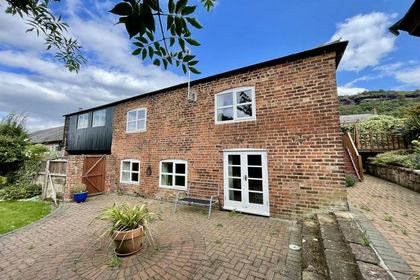 Added on 27/08/2026Barn Conversion
- Price
- Offers in Region of£500,000
Sparrow Grove Barns, Dragons Lane, Moston, Sandbach, Moston, Cheshire East CW11 England
Added on 24/04/2026Barn Conversion