Yoxall, Staffordshire
- Land size
- 21.76 acres
Key Features
- Circa 21.76 acres (8.81 hectares)
- Grade 3 permanent pasture
- Direct roadside access from the northern boundary
- Situated on the western edge of the village
- Mains water supply
- Offering a variety of uses subject to consents
- The land is offered for sale via Informal Tender method
Description
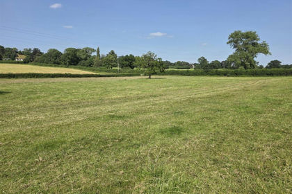
Land on the south side of Sandpits Lane extends to circa 21.76 acres (8.81 hectares) of Grade 3 permanent pasture, with direct roadside access from the northern boundary.
Guide Price - £200,000 to £225,000
The land has been in the same ownership since 1941, and is situated on the western edge of the village. Offering a variety of uses, subject to the necessary consents, with established hedgerows and a mains water supply.
Services
Mains water is connected. Additional mains services are believed to be within close proximity and interested parties are advised to make their own investigations.
Tenure
The land is to be sold Freehold with vacant possession. The sellers reserve the right to harvest a crop prior to Completion.
Title No. SF416766
Method of sale
The land is offered for sale via Informal Tender method. However our client reserves the right to conclude the sale by an alternative method if required.
Local Authority
East Staffordshire Borough Council
Mineral, sporting and timber rights
We are not aware of any exceptions, but interested parties are advised to make their own investigations.
Covenants/Conditions
It is assumed that the land is subject to existing covenants/conditions. Interested parties are advised to make their own investigations.
Overage/Uplift Clause
The sale is subject to Overage/Uplift Clauses. The north eastern paddock (circa 0.72 acres) will be subject to a 20% uplift for a period of 15 years, to capture any form of development, triggered on planning permission being granted, excluding equestrian uses, as defined within section 55 of the Town and Country Planning Act 1990.
The remaining land (circa 21.04 acres) will be subject to a 20% uplift (on either the land value or a percentage of the total lease payments, whichever is greater) for a period of 15 years, to capture renewable projects, triggered on planning permission being granted, as defined within section 55 of the Town and Country Planning Act 1990.
Further information is available upon request.
Public rights of way, wayleaves and easements
The property is sold subject to all rights of way, wayleaves and easements whether or not they are defined in this brochure.
The land is subject to public rights of way (as denoted on the sales plan) and rights of access for neighbouring land. Further information is available upon request.
Planning
For any enquiries regarding planning, please consult the local planning authority direct. The vendor has not sought planning permission for any form of development.
The selling agents will not provide advice/guidance on the planning history for the property/land. Interested parties are advised to make their own investigations. It is assumed that enquiries have been satisfied, prior to an offer being made.
Anti Money Laundering Regulations (AML)
In accordance with Anti Money Laundering Regulations (AML), we are required to request forms of identification and carry out due diligence on any parties connected to a successful offer. Should an offer be made on behalf of a business/company, AML due diligence will also be necessary. Proof/source of funding must be supplied, prior to offer acceptance.
Plans and boundaries
The plans within these particulars are based on Ordnance Survey data and provided for reference only. They are believed to be correct but accuracy is not guaranteed. The purchaser shall be deemed to have full knowledge of all boundaries and the extent of ownership. Neither the vendor nor the vendor’s agents will be responsible for defining the boundaries or the ownership thereof.
Vendors Solicitors
Nigel Davis Solicitors
3 - 4 Spire House, Ashbourne, Derbyshire
DE6 1DG
Viewings
Viewings are to be unaccompanied with a copy of these particulars in hand. Viewers are asked to make the selling agents aware of any intended visits.
Directions
Postcode – DE13 8NB
what3words – ///happening.trending.others
Map Location
Property details
- Tenure
- Freehold
- Council Tax Band
- TBC
- Date Posted
- 2026-06-10
Market Value Analysis
Compared with 73 Farmland & Pasture listings in West Midlands (10+ acres).
Utilities & Restrictions
Utilities
- Electricity
- Ask Agent
- Water
- Ask Agent
- Heating
- Ask Agent
- Broadband
- Ask Agent
- Sewerage
- Ask Agent
Rights & Restrictions
- Public Rights of Way
- Ask Agent
- Private Rights of Way
- Ask Agent
- Listed Property
- Ask Agent
- Restrictions
- Ask Agent
Property Features
- Accessibility
- Ask Agent
- Parking
- Ask Agent
- Garden
- Garden
Important notice: Information, maps and tags on this page are supplied by the advertising agent or generated automatically. LandSale has not verified them. Relying on these details is at your own risk, always carry out independent checks before committing to a purchase.
LandSale full disclaimer
Marketing information only - not formal particulars. The details on this website are provided for general guidance and do not constitute an offer or contract. Neither LandSale nor the advertising estate/land agent accepts responsibility for any inaccuracy.
1. Source of information
- Agent-supplied content: Core description, asking price, tenure, measurements, photographs and planning history are uploaded by the appointed agent, who remains solely responsible for their accuracy.
- Automated tags & categorisation: Property type, land-use class, acreage bands and similar labels may be applied by machine-learning models. They are intended as a helpful guide only and may not reflect the property's legal status or permitted use.
- Third-party & enriched data layers: Maps, boundary outlines, planning designations, soil reports, broadband coverage and other environmental or location-based insights are licensed from external suppliers. Such data are supplied “as is", may be incomplete or out of date and are subject to change without notice.
2. Verification required
Prospective purchasers must verify critical matters, including but not limited to planning permission, title boundaries, public rights of way, environmental constraints, acreage, services, access and VAT status, through their own inspections, specialist surveys, legal advisers and the selling agent before relying on the information or entering into any contract.
3. No warranty or liability
LandSale gives no warranty, express or implied, as to the accuracy, completeness or fitness for any particular purpose of the information displayed. LandSale shall not be liable for any loss, damage, cost or expense arising directly or indirectly from any use of or reliance on such information, save where liability may not be excluded by law.
4. Updates & feedback
If you believe any detail on this listing is inaccurate, please let us know. We will investigate and, where appropriate, update the listing or notify the agent.
© LandSale | Version 1.2 - January 2026
Similar properties for sale
- Price
- Guide Price£250,000
- Size
- 17.2 acres
Land at Oulton Road, Oulton, Staffordshire, ST15 8UT, Stone Rural, Staffordshire ST15 8UN England
Added on 10/07/2026Vacant Land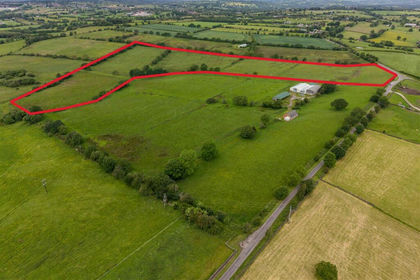
- Price
- Offers Over£200,000
- Size
- 23.3 acres
Tickhill Lane, Dilhorne, Stoke-On-Trent, Dilhorne, Staffordshire ST10 2PN England
Added on 24/06/2026Grazing Land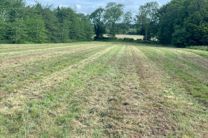
- Price
- Guide Price£250,000
- Size
- 14.11 acres
Land off Oaken Drive, Codsall, Staffordshire, Codsall, Staffordshire WV8 2EE England
Added on 03/07/2026Vacant Land
- Price
- Offers Over£180,000
- Size
- 24.21 acres
Land at Ford Wetley, Onecote, Leek, Onecote, Staffordshire ST13 7SD England
Added on 21/05/2026Grazing Land
- Price
- Offers Over£200,000
- Size
- 21.63 acres
Lot Two Land off Cossall Road, Trowell, Trowell, Nottinghamshire NG9 3PG England
Added on 23/05/2026Farmland
- Price
- Guide Price£250,000
- Size
- 22.08 acres
Alfreton, Derbyshire, South Wingfield, Derbyshire DE55 7NT England
Added on 29/01/2026Grazing Land
- Price
- Guide Price£195,000
- Size
- 12.19 acres
Bottom Lane (Whole) Market Drayton, Shropshire, TF9, Market Drayton, Shropshire TF9 1LS England
Added on 28/01/2026Grazing Land
- Price
- Offers in Excess of£150,000
- Size
- 12.7 acres
Land at Shellow Lane, North Rode, Congleton, Cheshire, North Rode, Cheshire East CW12 2NY England
Added on 04/06/2026Grazing Land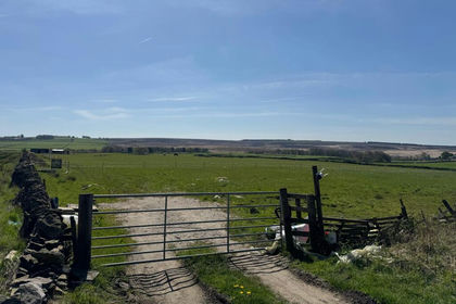
- Price
- Guide Price£160,000
- Size
- 11.8 acres
Land at Eastmoor, Chesterfield, Derbyshire S42 7DG, Brampton, Derbyshire S42 7DG England
Added on 22/03/2026Farmland
- Price
- Offers Over£190,000
- Size
- 13.08 acres
13.08 Acres Of Land Off Cookesmere Lane, Sandbach, Sandbach, Cheshire East CW11 1BH England
Added on 10/07/2026Grazing Land