Shepton Fields, Pulverbatch, Shrewsbury, Shropshire
- Land size
- 235 acres
- Bedrooms
- 4
- Bathrooms
- 1
Key Features
- 235-Acre First-Class Ring-Fenced Livestock Farm in Scenic Mid Shropshire
- Characterful Four Bedroom 1925 Farmhouse with Panoramic Countryside Views
- Historic Grade II Listed Mid-15th-Century Timber-Framed Cruck Barn
- Extensive Modern & Traditional Farm Buildings with Conversion Potential (STPP)
- Highly Accessible Location just 7 Miles from Shrewsbury
- EPC: E
- Freehold
Description
Situation: Introduction
Shepton Fields is an exceptional, established agricultural holding. Situated between 900 and 1,100 feet above sea level, the property occupies a commanding position in beautiful, unspoilt countryside, boasting breath-taking views to the south and east towards Shrewsbury, Telford, and The Wrekin.
This is a first-class livestock farm, fully equipped with stock-proof fencing across the holding to ensure secure and efficient land management, including natural ponds and thriving wildlife habitat, offering exceptional potential for biodiversity and private conservation. Over the last 5 years the farm has been utilised as a dairy young-stock unit, and a number of the fields have been used for sheep grazing. The land benefits from a private water supply which feeds the land, buildings and house.
Shepton Fields Farmhouse
Steeped in early 20th-century character, Shepton Fields Farmhouse is a substantial 1925 residence built with rendered brick walls beneath a pitched tiled roof offering the perfect blank canvas to create a lovely rural lifestyle home.
The practical ground floor layout provides ample space for family living and entertaining. A central hallway leads to two versatile reception rooms, a dedicated dining room, and a traditional kitchen with an adjoining back kitchen. A practical utility room keeps daily chores separate, while a conservatory provides open views of the surrounding Shropshire landscape. Upstairs, the first-floor features four well-proportioned bedrooms and a central family bathroom, offering a comfortable living environment.
Grade II Listed Barn & Outbuildings
Adjacent to the farmhouse is a historic, Grade II listed L-shaped barn. Originally a mid-15th-century longhouse extended in the early 17th century, it features a traditional timber-framed cruck construction encased in red brick and uncoursed limestone rubble under a corrugated iron roof.
Additionally, the yard contains traditional brick and stone farm buildings offering clear potential for residential conversion, subject to planning approval.
Farm Buildings & Agricultural Infrastructure
The property features a comprehensive and highly functional yard equipped with an extensive range of modern and traditional farm buildings..
Modern Livestock Housing: Large, multi-purpose steel portal-framed sheds provide well-ventilated, secure, and easily accessible space for cattle and sheep wintering, lambing, and calving operations.
Fodder & Machinery Storage: Classic Dutch barns offer generous clearance and excellent protection for large-scale hay, straw, and silage storage, ensuring essential winter feed supplies remain secure.
Traditional Outbuildings: A range of characterful, traditional brick and stone cow houses and stables add historic value to the yard while serving as highly adaptable spaces for dynamic farm requirements, stock handling, or workshop use.
The Farmland
Shepton Fields spans an impressive 235 acres of premium, versatile mid-Shropshire agricultural land, expertly laid out for high-yield livestock production and optimal grazing.
Strategic Ring-Fenced Layout: Most of the acreage is securely situated within a contiguous, ring-fenced block to the west of the farmstead. This main body of land sweeps dramatically upwards towards the scenic heights of Cothercott Hill, providing excellent, free-draining grazing terrain.
Eastern Parcel: Positioned to the east of the quiet, council-maintained "no through road" that leads to Underhill Hall sits a highly useful 28-acre block, perfect for segregated stocking, rotation, or dedicated fodder production.
Convenient Enclosures: The entire acreage is split into manageable, intelligently sized enclosures. This setup allows for seamless livestock rotation, easy stock management, and highly efficient field-to-yard operations.
An Enviable Mid-Shropshire Location
Nestled in the heart of Shropshire’s most breathtaking, unspoilt countryside, Shepton Fields offers a perfect blend of rural tranquillity, premium agricultural convenience, and outdoor adventure.
Positioned perfectly for livestock operations, the farm enjoys effortless connectivity to three premier regional livestock markets at Shrewsbury, Bishops Castle, and Welshpool.
The vibrant, historic county town of Shrewsbury sits just 7 miles away, providing an exceptional array of independent shops, fine dining, excellent schooling, and rapid transport links.
Located just 5 miles from the northern gateway of the spectacular Long Mynd hill range an expansive 5,200-acre National Trust playground on your doorstep.
Agricultural Schemes & Property Rights: Purchasers to make their own enquiries.
Rights of Way: The "Shropshire Way" walking trail crosses the fields adjacent to the south-eastern boundary of the farm.
Sporting and Mineral Rights:
Any existing rights are fully intact and are included in the sale.
Tenure and Possession:
There is an Agricultural Tenancy in place which is due to end on the 31st March 2027. The farmhouse itself is vacant.
Public Rights of Way:
The farm is sold subject to all existing rights of way.
Local Authority: Shropshire Council ).
EPC Rating: C
Boundaries, Hedges and Fences: The purchaser(s) shall be deemed have full knowledge of the boundaries and neither the vendors nor the Agents will be responsible for defining ownership of the boundaries, hedges or fences. All boundaries are deemed to be the responsibility of the purchaser unless expressly stated otherwise.
Services: Oil fired central heating. Private water supply from borehole on the property. Single phrase mains electricity. Private septic tank drainage.
Fixtures and Fittings: Whilst all attempts have been made to accurately describe the property in regard to fixtures and fittings, a comprehensive list will be made available by the seller’s solicitors.
Council Tax: Band D
Broadband & Mobile Data: Please conduct your own research to ensure the speeds meet your requirements.
Flood Risk: Surface water, rivers and sea: very low risk.
Tenure and Possession: The property is sold freehold subject to the tenancies in place and licences details of which are available from the Selling Agents upon request.
Wayleaves, Easements and Rights of Way: The property will be sold with the benefit of all wayleaves, easements and rights of way whether mentioned in these particulars or not.
Boundaries, Hedges and Fences: All boundaries are the responsibility of the purchaser.
what3words: wedge.strutting.hypocrit
Please Note: The barn adjacent to the farmhouse is Grade II Listed. There is asbestos present in a number of the farm buildings; a survey report is available from the agent.
Directions: From Bayston Hill Roundabout in Shrewsbury, take the exit onto the A49 towards the South. Continue on the A49 for 2.2 miles then turn right towards Exfords Green/Longden. Continue for 1.4 miles then turn left onto Exfords Green. In 0.7 miles. keep right where Exfords Green becomes Long Ln, and at the end of Long Ln, turn left. Continue for 2.1 miles and turn left onto a partially restricted usage road. Continue down this lane for 0.7 miles and Shepton Fields will be on your right.
What3Words: ///dirt.games.classmate
Map Location
Property details
- Tenure
- Freehold
- Council Tax Band
- TBC
- Date Posted
- 2026-06-07
Market Value Analysis
Compared with 19 Farms & Smallholdings listings in West Midlands (100+ acres).
Energy Performance Certificate
Energy Efficiency Rating
Based on UK Energy Performance Certificate standards (EU Directive 2002/91/EC)
Running costs are one side. Planning activity, flood history and ground risks for this location are in the full report.
Utilities & Restrictions
Utilities
- Electricity
- Ask Agent
- Water
- Ask Agent
- Heating
- Ask Agent
- Broadband
- Ask Agent
- Sewerage
- Ask Agent
Rights & Restrictions
- Public Rights of Way
- Ask Agent
- Private Rights of Way
- Ask Agent
- Listed Property
- Ask Agent
- Restrictions
- Ask Agent
Listed status, conservation areas and planning constraints for this location are in the full report.
Property Features
- Accessibility
- Ask Agent
- Parking
- Ask Agent
- Garden
- Garden
Beyond the particulars: planning activity, flood history, heritage and ground risks, checked for this exact spot.
Connectivity
Broadband
Fastest speed available at this postcode
1.8 Gbps
Gigabit full fibre
Suitable for
- 4K streaming on every screen
- Full-time home working
- Online gaming & big downloads
Fixed wireless access may also be an option here.
Mobile signal
Outdoor predictions; indoor signal depends on building materials.
Ofcom Connected Nations postcode-level predictions. Speeds and signal are modelled, not measured, and vary between addresses and providers.
Signal is the easy part. Planning activity, flood history and protected designations here are in the full report.
Nearest Schools
Primary
- Pontesbury CofE Primary School3.2 milesOfsted: Good *
- Ages
- 4 to 11
- Pupils
- 211
- Type
- Voluntary controlled school
- Faith
- Church of England
- St Edward's CofE Primary School3.3 milesOfsted report card · Jun 2026
- Ages
- 4 to 11
- Pupils
- 31
- Type
- Academy sponsor led
- Faith
- Church of England
- Longden CofE Primary School3.5 milesOfsted report card · Feb 2026
- Ages
- 2 to 11
- Pupils
- 140
- Type
- Voluntary aided school
- Faith
- Church of England
- Minsterley Primary School3.9 milesNo Ofsted rating
- Ages
- 2 to 11
- Pupils
- 173
- Type
- Community school
- Longnor CofE Primary School4 milesOfsted: Outstanding
- Ages
- 3 to 11
- Pupils
- 116
- Type
- Voluntary controlled school
- Faith
- Church of England
Secondary
- Mary Webb School and Science College3.3 milesOfsted: Good
- Ages
- 11 to 16
- Pupils
- 632
- Type
- Academy converter
- Church Stretton School4.5 milesNo Ofsted rating
- Ages
- 11 to 16
- Pupils
- 539
- Type
- Academy converter
- Meole Brace School7 milesOfsted: Good
- Ages
- 11 to 16
- Pupils
- 1,316
- Type
- Academy converter
- The Priory School7.2 milesOfsted: Good
- Ages
- 11 to 16
- Pupils
- 852
- Type
- Academy converter
- Belvidere School9.1 milesOfsted: Requires improvement *
- Ages
- 11 to 16
- Pupils
- 830
- Type
- Academy converter
* Latest graded judgement covers quality of education only; no overall grade was issued under the 2024-25 inspection framework.
Distances are straight-line from the advertised location. Source: the national school registers (DfE, Welsh Government, Scottish Government) and Ofsted.
Schools are just the start: sold prices nearby, planning activity and any flood history are in the full report.
Amenities
Supermarket
GP surgery
Pharmacy
Hospital
Straight-line distances from the advertised location. Sources: NHS records, Geolytix supermarket locations, OS Open Greenspace and the national trails registers.
The area stacks up? Now check the location itself: planning nearby, protected designations and past flooding.
Getting Around
Nearest station
Nearest bus stop
Typical drive times
Straight-line distances from the advertised location; drive times are typical free-flow times over OpenStreetMap road data, so allow more at peak. Public transport locations from DfT NaPTAN.
Easy to reach matters. So do planning activity, flood history and ground risks: all in the full report.
Flood Risk
From Environment Agency flood map open data, checked around the advertised map pin and allowing for the listed acreage where known. This summary comes from LandSale, the advertising platform, not from the listing agent, and is not part of the agent's particulars. Risk can vary across a single holding, so verify anything critical through your own searches before committing.
Rivers and the sea
Mapped within the area searched, not at the advertised map pin itself.
Surface water
Mapped within the area searched, not at the advertised map pin itself.
These bandings are the summary. Where this location sits on the flood maps, plus planning activity, heritage and ground risks, is in the full report.
Important notice: Information, maps and tags on this page are drawn from the advertising agent's marketing materials or generated automatically. LandSale has not verified them. Relying on these details is at your own risk, always carry out independent checks before committing to a purchase.
LandSale full disclaimer
Marketing information only - not formal particulars. The details on this website are provided for general guidance and do not constitute an offer or contract. Neither LandSale nor the advertising estate/land agent accepts responsibility for any inaccuracy.
1. Source of information
- Listing content: Core description, asking price, tenure, measurements, photographs and planning history originate from the marketing materials of the advertising estate or land agent. LandSale does not author this content and cannot guarantee its accuracy.
- Automated tags & categorisation: Property type, land-use class, acreage bands and similar labels may be applied by machine-learning models. They are intended as a helpful guide only and may not reflect the property's legal status or permitted use.
- Third-party & enriched data layers: Maps, boundary outlines, planning designations, soil reports, broadband coverage and other environmental or location-based insights are licensed from external suppliers. Such data are supplied “as is", may be incomplete or out of date and are subject to change without notice.
2. Verification required
Prospective purchasers must verify critical matters, including but not limited to planning permission, title boundaries, public rights of way, environmental constraints, acreage, services, access and VAT status, through their own inspections, specialist surveys, legal advisers and the selling agent before relying on the information or entering into any contract.
3. No warranty or liability
LandSale gives no warranty, express or implied, as to the accuracy, completeness or fitness for any particular purpose of the information displayed. LandSale shall not be liable for any loss, damage, cost or expense arising directly or indirectly from any use of or reliance on such information, save where liability may not be excluded by law.
4. Updates & feedback
If you believe any detail on this listing is inaccurate, please let us know. We will investigate and, where appropriate, update the listing or notify the agent.
© LandSale | Version 1.3 - August 2026
Listing agent
Balfours LLP, Shrewsbury
The Square, Market Street, Shrewsbury, SY1 1LG
View agent profileSimilar properties for sale
- Price
- Guide Price£1,795,000
Added on 29/01/2026Country Home
- Price
- Guide Price£1,395,000
- Size
- 3.67 acres
Cunnery Road, Church Stretton, Shropshire, SY6, Church Stretton, Shropshire SY6 England
Added on 15/07/2026House with Land
- Price
- Guide Price£2,900,000
Westhope Country Retreats, Craven Arms, Diddlebury, Shropshire SY7 England
Added on 28/08/2026Holiday Let Property
- Price
- £1,650,000
- Size
- 5.85 acres
Seifton House, Seifton, Ludlow, Shropshire, Culmington, Shropshire SY8 England
Added on 11/07/2026Country Home
- Price
- Guide Price£2,500,000
- Size
- 8 acres
Dovaston, Kinnerley, Shropshire, Kinnerley, Shropshire SY10 England
Added on 13/06/2026Equestrian property
- Price
- Offers in Region of£1,350,000
- Size
- 4 acres
Added on 30/07/2026House with Land
- Price
- Guide Price£1,350,000
- Size
- 2 acres
Monkhopton, Bridgnorth, Shropshire, WV16, Monkhopton, Shropshire WV16 England
Added on 29/01/2026Country Home
- Price
- Guide Price£1,375,000
- Size
- 52.14 acres
Oakwood Grange, Bings Heath, Astley, Shropshire, SY4, Shawbury, Shropshire SY4 England
Added on 20/07/2026Farm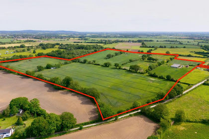
- Price
- Guide Price£1,375,000
- Size
- 52.14 acres
Bings Heath, Astley, Shrewsbury, Shawbury, Shropshire SY4 England
Added on 21/07/2026Development Land
- Price
- Guide Price£1,650,000
- Size
- 11.63 acres
Llanerchydol Hall, Llanerchydol, Welshpool, Powys, Welshpool, Powys SY21 Wales
Added on 24/05/2026House with Land