18.13 acres of Arable Land, Aylmerton
- Land size
- 18.13 acres
Description
Location, Situation and Directions
The land is located on the edge of the village of Aylmerton in the district of North Norfolk and within close proximity of the coastal towns of Sheringham and Cromer. The market town of Holt is approximately 7.2 miles to the west and Aylsham approximately 11 miles to the south, both of which offer multiple amenities. From the town of Holt, head east along the A148 Cromer/Holt Road, follow for approximately 0.7 miles. At the roundabout, take the first exit and continue on the A148. Follow for approximately 5.4 miles then take a right turn at the sign for ‘St Andrews School’. Follow the road round and the private access track to the land is on the right, as shown on the site plan.
What 3 Words: ///tastes.lends.nurse
Description
The land comprises of 18.13 acres (7.34 hectares) of arable land located off the A148 in Aylmerton, North Norfolk. The arable land is formed of a single field parcel, surrounded by further agricultural land. Previous cropping of the land includes winter barley, spring barley and sugar beet.
Land Grade & Soil Type
The land is classified as Grade 2 on the Land Classification Soil Series of England and Wales with soils of Wick 1 series being deep well drained coarse loamy often stoneless soils. Suitable for the growing of cereals, peas and beans, sugar beet and potatoes, some field vegetables and horticultural crops, including bulbs.The land is cropped with potatoes under licence.
Easements, Wayleaves and Rights of Way
The property is offered subject to and with the benefit of all existing rights of way whether public or private light support drainage or water electricity supplies and other rights and obligations easements quasieasements and restrictive covenants and all existing and proposed wayleaves, poles, masts, pylons, stays, cables, drains, water, gas and other pipes whether referred to herein or not.
Boundaries, Plans, Areas, Schedules and Disputes
There is no boundary feature established along the north boundary of the land. The existing electricity poles form the sale boundary and the Purchaser will need to establish a hedge along the north boundary following completion. The Purchaser will be deemed to have full knowledge of the boundaries and areas and any mistake or error shall not annul the sale nor entitle any party to compensation in respect thereof. Should any dispute arise as to the boundaries or any points arise on the general remarks, stipulations, particulars, schedule, plan or the interpretation of any of them, questions shall be referred to the selling Agent whose decision acting as Experts shall be final.
Tenure
The land is to be offered freehold with the benefit of vacant possession upon completion, subject to those right(s) of holdover as detailed herein.
Measurements and Other Information
All measurements and areas are approximate and based on data provided by the RPA/Land App. Whilst we endeavour to make our sales particulars accurate and reliable, if there is any point which is of particular importance to you, please contact this office and we will be pleased to check the information for you, particularly if contemplating travelling some distance to view the property.
Method of Sale
The property is offered for sale initially by private treaty as a whole, as described in these particulars. The Vendor and their Agent reserves the right to invite best and final offers and/or offer the property for sale by private auction if there is a substantial level of interest. Interested parties should note that the Vendors have indicated they may be prepared to divide the land into smaller Lots subject to an agreement.
Employees
It is not anticipated that any employees will be transferred to the Purchaser under the Transfer of Undertakings (Protection of Employment) Regulations “TUPE”.
Early Entry
The land is subject to a cropping licence to a third party terminating 31 October 2026. Early entry prior to this date is not permitted.
Irrigation
The land does not benefit from irrigation nor an abstraction licence.
Drainage
General drainage rates for the land is payable to the Environment Agency. Payments will be apportioned according to the date of completion. The land is not under-drained.
Services
We are not aware of any services to the land.
Access
The land is accessed via private third party owned tracks from Holt Road, as shown shaded brown on the plan herein. The land will be sold with the benefit of a right of way for agricultural vehicles for agricultural purposes only along the access tracks shown on the site plan subject to contributing a fair proportion towards maintenance costs. Further details can be provided.
Viewing and Health & Safety
Viewing is strictly by prior appointment only with the Vendor’s Agent, Cruso & Wilkin. For your own personal safety, we would ask you to be as vigilant as possible when making an inspection. We regret to advise that children and/or pets are not permitted on the property.
Planning
The are no active planning applications in relation to the land however potential Purchasers should make their own enquiries in this regard.
Exchange of Contract and Completion
A 10% deposit will be payable upon exchange of contracts.
Value Added Tax
Should the sale of this property, or any rights attached to it, become chargeable to Value Added Tax, then the tax at the prevailing rate will be payable by the Purchaser in addition to the contract price.
Sporting, Timber & Mineral Rights
The land is subject to a deed granting the shooting rights to a third party. The shooting rights are excluded. The mineral rights and timber rights are included insofar as they are owned subject to statutory exclusions.
Development Covenant/Overage
The land is subject to a restrictive covenant. Further details can be provided on request.
Environment Schemes
The land is not included in any Agri-Environment Schemes.
Basic Payment Scheme
The land is registered with the Rural Payments Agency (RPA). Any remaining Delinked Payments are reserved to the Vendor.
Holdover
The Vendor reserves a right of holdover, if required, to harvest the potatoes under licence up to and including 31st October 2026. There is no sugar beet contract available.
Nitrate Vulnerable Zones
The land falls within a designated Nitrate Vulnerable Zone.
Local Authority
North Norfolk District Council, Council Offices, Holt Road, Cromer, Norfolk NR27 9EN
Tel:
Norfolk County Council, County Hall, Martineau Lane, Norwich, Norfolk NR1 2DH
Tel:
Sole Agents:
Cruso & Wilkin, The Estate Office, Church Farm, Station Road, Hillington, King’s Lynn, Norfolk PE31 6DH
Tel:
Solicitors:
Fraser Dawbarns, 21 Tuesday Market Place, King’s Lynn PE30 1JW
Tel:
Map Location
Property details
- Tenure
- Ask Agent
- Council Tax Band
- Ask Agent
- Date Posted
- 2026-06-06
Market Value Analysis
Compared with 76 Farmland & Pasture listings in East Anglia (10+ acres).
Utilities & Restrictions
Utilities
- Electricity
- Ask Agent
- Water
- Ask Agent
- Heating
- Ask Agent
- Broadband
- Ask Agent
- Sewerage
- Ask Agent
Rights & Restrictions
- Public Rights of Way
- Ask Agent
- Private Rights of Way
- Ask Agent
- Listed Property
- Ask Agent
- Restrictions
- Ask Agent
Property Features
- Accessibility
- Ask Agent
- Parking
- Ask Agent
- Garden
- Ask Agent
Important notice: Information, maps and tags on this page are supplied by the advertising agent or generated automatically. LandSale has not verified them. Relying on these details is at your own risk, always carry out independent checks before committing to a purchase.
LandSale full disclaimer
Marketing information only - not formal particulars. The details on this website are provided for general guidance and do not constitute an offer or contract. Neither LandSale nor the advertising estate/land agent accepts responsibility for any inaccuracy.
1. Source of information
- Agent-supplied content: Core description, asking price, tenure, measurements, photographs and planning history are uploaded by the appointed agent, who remains solely responsible for their accuracy.
- Automated tags & categorisation: Property type, land-use class, acreage bands and similar labels may be applied by machine-learning models. They are intended as a helpful guide only and may not reflect the property's legal status or permitted use.
- Third-party & enriched data layers: Maps, boundary outlines, planning designations, soil reports, broadband coverage and other environmental or location-based insights are licensed from external suppliers. Such data are supplied “as is", may be incomplete or out of date and are subject to change without notice.
2. Verification required
Prospective purchasers must verify critical matters, including but not limited to planning permission, title boundaries, public rights of way, environmental constraints, acreage, services, access and VAT status, through their own inspections, specialist surveys, legal advisers and the selling agent before relying on the information or entering into any contract.
3. No warranty or liability
LandSale gives no warranty, express or implied, as to the accuracy, completeness or fitness for any particular purpose of the information displayed. LandSale shall not be liable for any loss, damage, cost or expense arising directly or indirectly from any use of or reliance on such information, save where liability may not be excluded by law.
4. Updates & feedback
If you believe any detail on this listing is inaccurate, please let us know. We will investigate and, where appropriate, update the listing or notify the agent.
© LandSale | Version 1.2 - January 2026
Listing agent
Cruso & Wilkin, Land & Commercial
The Estate Office, Church Farm, Station Road, Hillington, PE31 6DH
Contact Cruso & Wilkin, Land & Commercial
The Estate Office, Church Farm, Station Road, Hillington, PE31 6DH
View agent profileSimilar properties for sale

- Price
- Guide Price£150,000
- Size
- 6 acres
Goose Lane, Thwaite Common, NR11, Alby with Thwaite, Norfolk NR11 7QG England
Added on 30/06/2026Vacant Land
- Price
- £300,000
- Size
- 9.36 acres
Added on 02/04/2026Amenity Land
- Price
- Guide Price£290,000
- Size
- 71.81 acres
Added on 29/01/2026Grazing Land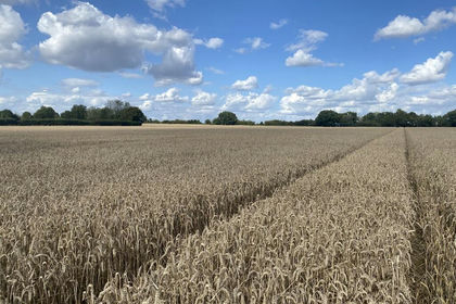
- Price
- Guide Price£315,000
- Size
- 31.53 acres
Added on 29/01/2026Arable Land
- Price
- £225,000
- Size
- 23.49 acres
High Street, Fincham, King's Lynn, Fincham, Norfolk PE33 9EL England
Added on 29/01/2026Grazing Land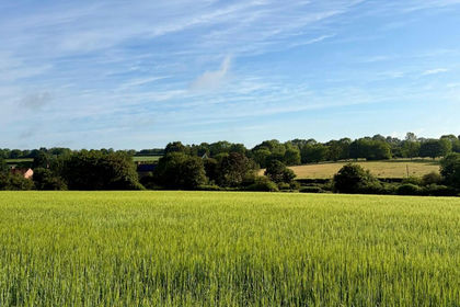
- Price
- From£160,000
- Size
- 19.37 acres
Added on 14/06/2026Agricultural Land
- Price
- Guide Price£225,000
- Size
- 1.09 acres
Off Sparrowhawk Road, Halesworth, Holton, Suffolk IP19 8QP England
Added on 12/06/2026Farm
- Price
- Offers in Region of£200,000
- Size
- 1.36 acres
Skegness Road, Chapel St. Leonards, Skegness, Ingoldmells, Lincolnshire PE25 1JP England
Added on 29/01/2026Pasture
- Price
- £225,000
- Size
- 2.13 acres
Added on 18/07/2026Vacant Land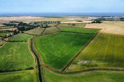
- Price
- Offers in Region of£275,000
- Size
- 33.78 acres
Added on 29/01/2026Pasture