London Road, Tetbury, GL8
- Land size
- 4 acres
Key Features
- Established Cafe, Pub & Restaurant Business + Multiple Income Streams
- Prime Location/Leisure Destination: Transport Links, Walking & Cycle Routes Nearby
- Circa 4 Acres Of Land & Large Car Parking Area
- Spacious 3 Bed Managers Accommodation, Refurbished Bed & Breakfast Room & Glamping/2 Shepherds Huts
- Extensive Recent Upgrades; 3-Phase Eectric, New Boiler & Borehole Water System
- A Landmark Building With Cotswold Character & Charm
- Exposed Stone/Brickwork & Ceiling Beams, New Oak Flooring & Log Burning Stoves
- Outbuildings That Offer Development Opportunity & Private Events/Functions
Description
Established Pub, Restaurant & Accommodation Business – Going Concern
A rare opportunity to acquire The Trouble House, a well known, characterful and fully operational hospitality business with an excellent reputation and supported by review platforms such as trip advisor, Google reviews and booking.com
This long established, family run pub and restaurant is renowned for quality food, drink and warm, attentive service. It enjoys a loyal local customer base, attracts destination diners from across the Cotswolds, and benefits from steady passing trade thanks to its prominent position on the outskirts of Tetbury. The property offers ample parking, a detached barn ideal for private hire, and an attractive large and walled garden that enhances trading during fine weather.
Inside, the business provides well balanced trading areas designed for year round operation, including a welcoming bar, comfortable dining spaces and an established food led offer. The layout supports efficient day to day service while also offering flexibility for private events, group bookings and seasonal variations in demand. The overall presentation reflects a business deeply embedded in its community and popular with both regulars and new visitors.
The first floor includes spacious three double bedroom managers’ accommodation (plus office/smaller bedroom), providing valuable on site living space or additional rental income potential. This accommodation supports tourism demand and adds resilience to the trading model, with scope for further development if desired.
Externally, generous customer seating and landscaped outdoor areas enhance the venue’s appeal during warmer months and help drive incremental food and drink sales. The setting complements the property’s charm and reinforces its position as a destination venue.
Significant behind the scenes investment has been made in recent years, strengthening the operational infrastructure and reducing future capital expenditure. Upgrades include a full electrical conversion from single to three phase power with new smart meter and master fuse board, a new boiler installed in December 2025, and a new borehole pump and internal water system installed at the same time. High speed fibre broadband (Gigaclear) supports business operations and guest expectations. Note, A new sewage treatment system and internal grease trap plant is scheduled for installation April 2026, further strengthening the site’s long term resilience.
Guest accommodation has also been enhanced. A B&B room was been created, while two glamping shepherd huts, all contributing to additional income and strong seasonal appeal.
Externally, the property benefits from a large off road car park, extensive landscaped gardens and a barn well suited to events, private hire and functions. An additional outbuilding offers clear development potential, and the circa four acre site open up further opportunities such as expanded accommodation, enhanced events use or alternative leisure ventures, subject to the necessary consents.
The setting adds significant value to the offering. Beautiful walking routes run nearby, and the property sits opposite the end of National Cycle Route 48, drawing in cyclists, walkers and passing trade throughout the year. This strong leisure connection and local tourist attractions (Highgrove, Gatcombe Park, Polo Clubs, Westonbirt, Castle Coombe etc) supports food and drink sales, overnight stays and outdoor events, while the surrounding land provides a sense of space and privacy increasingly sought after by customers and operators alike.
The business is offered for sale due to personal circumstances and presents an exceptional opportunity for a new operator to take over a profitable, turnkey enterprise with multiple income streams and clear potential for further growth. Opportunities exist to increase turnover through extended opening hours, enhanced food offerings, events programming and targeted marketing
Website Link:
Available as a commercial going concern, with full trading information and EPC supplied to genuinely interested parties following an initial enquiry.
Rateable Value Effective 1st April 2026 £19,000.
Viewing strictly by appointment only.
Agents Note: The seller is a connected person to The Agency UK
Map Location
Property details
- Tenure
- Freehold
- Council Tax Band
- A
- Date Posted
- 2026-05-25
Energy Performance Certificate
Energy Efficiency Rating
Based on UK Energy Performance Certificate standards (EU Directive 2002/91/EC)
Running costs are one side. Planning activity, flood history and ground risks for this location are in the full report.
Utilities & Restrictions
Utilities
- Electricity
- Ask Agent
- Water
- Ask Agent
- Heating
- Ask Agent
- Broadband
- Ask Agent
- Sewerage
- Ask Agent
Rights & Restrictions
- Public Rights of Way
- Ask Agent
- Private Rights of Way
- Ask Agent
- Listed Property
- Ask Agent
- Restrictions
- Ask Agent
Listed status, conservation areas and planning constraints for this location are in the full report.
Property Features
- Accessibility
- Ask Agent
- Parking
- Parking Available
- Garden
- Garden
Beyond the particulars: planning activity, flood history, heritage and ground risks, checked for this exact spot.
Connectivity
Broadband
Fastest speed available at this postcode
9 Mbps
Under 10 Mbps here
Suitable for
- Basic browsing & email
Mobile signal
Predicted 4G and 5G signal; indoor signal depends on building materials.
Ofcom Connected Nations postcode-level predictions. Speeds and signal are modelled, not measured, and vary between addresses and providers.
Signal is the easy part. Planning activity, flood history and protected designations here are in the full report.
Nearest Schools
Primary
- St Mary's Church of England Primary School1.8 milesNo Ofsted rating
- Ages
- 4 to 11
- Pupils
- 282
- Type
- Academy converter
- Faith
- Church of England
- Rodmarton Primary School2.5 milesOfsted report card · Jun 2026
- Ages
- 4 to 11
- Pupils
- 66
- Type
- Community school
- Avening Primary School2.7 milesNo Ofsted rating
- Ages
- 4 to 11
- Pupils
- 107
- Type
- Academy converter
- Crudwell CofE Primary School3 milesNo Ofsted rating
- Ages
- 4 to 11
- Pupils
- 132
- Type
- Voluntary controlled school
- Faith
- Church of England
- Minchinhampton Primary Academy4.3 milesOfsted: Good *
- Ages
- 3 to 11
- Pupils
- 260
- Type
- Academy converter
- Faith
- Church of England
Secondary
- Sir William Romney's School1.7 milesNo Ofsted rating
- Ages
- 11 to 16
- Pupils
- 495
- Type
- Academy converter
- Malmesbury School5 milesOfsted: Outstanding
- Ages
- 11 to 18
- Pupils
- 1,438
- Type
- Academy converter
- Thomas Keble School5.6 milesNo Ofsted rating
- Ages
- 11 to 16
- Pupils
- 718
- Type
- Academy converter
- Cirencester Deer Park School7.1 milesNo Ofsted rating
- Ages
- 11 to 16
- Pupils
- 1,020
- Type
- Academy converter
- Stroud High School7.7 milesOfsted: Outstanding
- Ages
- 11 to 18
- Pupils
- 1,144
- Type
- Academy converter
- Gender
- Girls
* Latest graded judgement covers quality of education only; no overall grade was issued under the 2024-25 inspection framework.
Distances are straight-line from the advertised location. Source: the national school registers (DfE, Welsh Government, Scottish Government) and Ofsted.
Schools are just the start: sold prices nearby, planning activity and any flood history are in the full report.
Amenities
Supermarket
GP surgery
Pharmacy
Hospital
Straight-line distances from the advertised location. Sources: NHS records, Geolytix supermarket locations, OS Open Greenspace and the national trails registers.
The area stacks up? Now check the location itself: planning nearby, protected designations and past flooding.
Getting Around
Nearest station
Nearest bus stop
Typical drive times
Straight-line distances from the advertised location; drive times are typical free-flow times over OpenStreetMap road data, so allow more at peak. Public transport locations from DfT NaPTAN.
Easy to reach matters. So do planning activity, flood history and ground risks: all in the full report.
Flood Risk
Environment Agency open data, checked around the advertised map pin for the listed acreage. Long-term risk counts flood defences; the planning map's flood zones do not. Provided by LandSale, not the listing agent, and not part of the agent's particulars. Risk varies across a holding, so verify before committing.
Rivers and the sea
Planning map: Flood Zone 1.
Surface water
These bandings are the summary. Where this location sits on the flood maps, plus planning activity, heritage and ground risks, is in the full report.
Important notice: Information, maps and tags on this page are drawn from the advertising agent's marketing materials or generated automatically. LandSale has not verified them. Relying on these details is at your own risk, always carry out independent checks before committing to a purchase.
LandSale full disclaimer
Marketing information only - not formal particulars. The details on this website are provided for general guidance and do not constitute an offer or contract. Neither LandSale nor the advertising estate/land agent accepts responsibility for any inaccuracy.
1. Source of information
- Listing content: Core description, asking price, tenure, measurements, photographs and planning history originate from the marketing materials of the advertising estate or land agent. LandSale does not author this content and cannot guarantee its accuracy.
- Automated tags & categorisation: Property type, land-use class, acreage bands and similar labels may be applied by machine-learning models. They are intended as a helpful guide only and may not reflect the property's legal status or permitted use.
- Third-party & enriched data layers: Maps, boundary outlines, planning designations, soil reports, broadband coverage and other environmental or location-based insights are licensed from external suppliers. Such data are supplied “as is", may be incomplete or out of date and are subject to change without notice.
2. Verification required
Prospective purchasers must verify critical matters, including but not limited to planning permission, title boundaries, public rights of way, environmental constraints, acreage, services, access and VAT status, through their own inspections, specialist surveys, legal advisers and the selling agent before relying on the information or entering into any contract.
3. No warranty or liability
LandSale gives no warranty, express or implied, as to the accuracy, completeness or fitness for any particular purpose of the information displayed. LandSale shall not be liable for any loss, damage, cost or expense arising directly or indirectly from any use of or reliance on such information, save where liability may not be excluded by law.
4. Updates & feedback
If you believe any detail on this listing is inaccurate, please let us know. We will investigate and, where appropriate, update the listing or notify the agent.
© LandSale | Version 1.3 - August 2026
Listing agent
TAUK, Covering Nationwide
Covering Nationwide
Similar properties for sale
- Price
- Guide Price£650,000
Methuen Park, Chippenham, Wiltshire, SN14, Chippenham, Wiltshire SN14 England
Added on 17/07/2026Development Land
- Price
- £600,000
- Size
- 0.16 acres
Added on 17/07/2026Industrial Land
- Price
- Guide Price£650,000
Added on 03/10/2026Pub
- Price
- £1,100,000
- Size
- 0.5 acres
W-622286 - Cross House, High Street, Doynton BS30, Doynton, South Gloucestershire BS30 England
Added on 08/08/2026Pub
- Price
- Guide Price£1,100,000
- Size
- 0.5 acres
High Street, Doynton, Bristol, Gloucestershire, BS30, Doynton, South Gloucestershire BS30 England
Added on 28/07/2026Pub
- Price
- Guide Price£750,000
- Size
- 0.12 acres
Station Yard, Station Approach, Melksham, Wiltshire, Melksham, Wiltshire SN12 England
Added on 17/07/2026Industrial Land
- Price
- £575,000
Added on 29/01/2026Pub
- Price
- £995,000
- Size
- 1.6 acres
Added on 13/06/2026Development Land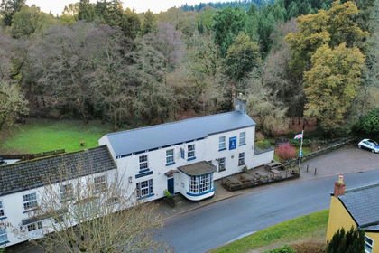
- Price
- Offers in Region of£775,000
Added on 25/05/2026Commercial Land
- Price
- £1,200,000
- Size
- 0.15 acres
Warmley Business Park, Crown Way, Bristol, Siston, South Gloucestershire BS30 England
Added on 10/10/2026Warehouse