Residential Barn Conversions
- Land size
- 1.61 acres
Key Features
- Residential development site with amenity land
- Permitted Class Q Change of Use for two traditional barns
- 0.88 acres STMS of amenity land
Description
Summary
- Available in three lots or as a whole
- Lot 1: Principal Barn conversion
- Lot 2: Single Storey Barn
- Lot 3: Amenity Land, in all approximately 0.88 acres (0.36 ha)
- Change of Use Class Q planning permission granted for each respective barn.
- Site area approximately 1.61 acres (0.66 hectares) in total apportioned over the three lots.
The land is offered for sale in three lots or as a whole.
Lot 1 as the Principal Barn 0.12 ha (0.29 acres)
A two storey, traditional barn of brick and flint construction under pantile roof. The property includes a covered, open-sided store adjoining to the rear and the west of the main barn. All of which is included in the planning conversion for a two storey home, retaining traditional features and the benefit of four bedrooms and an expansive open plan living space.
Lot 2 as the Barn 0.18 ha (0.44 acres)
A single storey barn of mixed construction materials including traditional brick and flint under pantile roof. The planning provides a three bedroom bungalow with open plan living space and a private courtyard.
Lot 3 as Amenity Land 0.36 ha (0.89 acres)
Grade 2 parcel of amenity land in the south east corner of an existing agricultural field.
Further land may be available by separate negotitation.
Site DescriptionThe site measures approximately 1.61 acres (0.66 hectares) in total and is accessed from Vong Lane.
The site is bordered by residential properties to the west and two further barn conversions have been completed to the north east.
Planning
The site falls under the jurisdiction of King’s Lynn and West Norfolk Borough Council and Norfolk County Council.
The site benefits from “Notification for Prior Approval for the Change of Use of Agricultural Building to One Dwellinghouse (Schedule 2, Part 3, Class Q)”. The planning reference numbers are 24/00361/PACU3 and 26/00052/PACU3, further information and relevant planning documents can be found on the Planning Department page of the Borough Council of King’s Lynn and West Norfolk.
Access
Access to the site is off the highway known as Vong Lane. Rights of access for all purposes will be granted to the Purchaser over the shared access shaded brown on the attached plan. The Purchaser will be under a shared responsibility obligation to maintain the road.
Map Location
Property details
- Tenure
- Freehold
- Council Tax Band
- Ask Agent
- Date Posted
- 2026-05-20
Market Value Analysis
Compared with 127 Development Land listings in East Anglia (1+ acres).
Utilities & Restrictions
Utilities
- Electricity
- Ask Agent
- Water
- Ask Agent
- Heating
- Ask Agent
- Broadband
- Ask Agent
- Sewerage
- Ask Agent
Rights & Restrictions
- Public Rights of Way
- Ask Agent
- Private Rights of Way
- Ask Agent
- Listed Property
- Ask Agent
- Restrictions
- Ask Agent
Property Features
- Accessibility
- Ask Agent
- Parking
- Ask Agent
- Garden
- Ask Agent
Important notice: Information, maps and tags on this page are supplied by the advertising agent or generated automatically. LandSale has not verified them. Relying on these details is at your own risk, always carry out independent checks before committing to a purchase.
LandSale full disclaimer
Marketing information only - not formal particulars. The details on this website are provided for general guidance and do not constitute an offer or contract. Neither LandSale nor the advertising estate/land agent accepts responsibility for any inaccuracy.
1. Source of information
- Agent-supplied content: Core description, asking price, tenure, measurements, photographs and planning history are uploaded by the appointed agent, who remains solely responsible for their accuracy.
- Automated tags & categorisation: Property type, land-use class, acreage bands and similar labels may be applied by machine-learning models. They are intended as a helpful guide only and may not reflect the property's legal status or permitted use.
- Third-party & enriched data layers: Maps, boundary outlines, planning designations, soil reports, broadband coverage and other environmental or location-based insights are licensed from external suppliers. Such data are supplied “as is", may be incomplete or out of date and are subject to change without notice.
2. Verification required
Prospective purchasers must verify critical matters, including but not limited to planning permission, title boundaries, public rights of way, environmental constraints, acreage, services, access and VAT status, through their own inspections, specialist surveys, legal advisers and the selling agent before relying on the information or entering into any contract.
3. No warranty or liability
LandSale gives no warranty, express or implied, as to the accuracy, completeness or fitness for any particular purpose of the information displayed. LandSale shall not be liable for any loss, damage, cost or expense arising directly or indirectly from any use of or reliance on such information, save where liability may not be excluded by law.
4. Updates & feedback
If you believe any detail on this listing is inaccurate, please let us know. We will investigate and, where appropriate, update the listing or notify the agent.
© LandSale | Version 1.2 - January 2026
Listing agent
Cruso & Wilkin, Land & Commercial
The Estate Office, Church Farm, Station Road, Hillington, PE31 6DH
Contact Cruso & Wilkin, Land & Commercial
The Estate Office, Church Farm, Station Road, Hillington, PE31 6DH
View agent profileSimilar properties for sale

- Price
- Guide Price£375,000
- Size
- 1.5 acres
Summer End Farm, Gayton Road, East Walton, East Winch, Norfolk PE32 1LH England
Added on 25/05/2026Development Land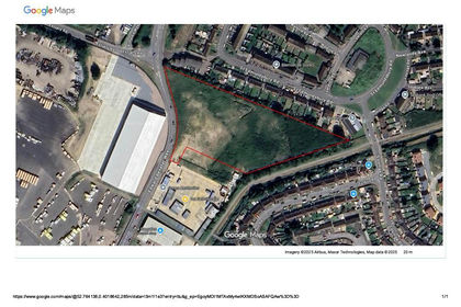
- Price
- Guide Price£400,000
- Size
- 4.18 acres
Edward Benefer Way, King's Lynn, Norfolk, PE30, North West Norfolk, Norfolk PE30 2FN England
Added on 29/01/2026Development Land
- Price
- £550,000
- Size
- 4.33 acres
Added on 15/05/2026Development Land
- Price
- Offers in Region of£350,000
Old Church Road, Terrington St. John, Wisbech, Terrington St. John, Norfolk PE14 7XA England
Added on 29/01/2026Development Land Added on 15/06/2026Development Land
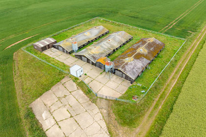
- Price
- Guide Price£400,000
- Size
- 0.85 acres
Norwich Road, Fakenham, Norfolk, NR21, Fakenham, Norfolk NR21 8LZ England
Added on 28/05/2026Development Land
- Price
- Offers in Excess of£400,000
- Size
- 0.8 acres
Lynn Road, Wisbech, Cambridgeshire, PE13 3EE, Wisbech, Cambridgeshire PE13 3EE England
Added on 29/01/2026Development Land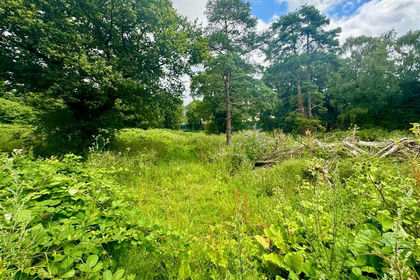
- Price
- Guide Price£350,000
Peatlings Lane, WISBECH, Leverington, Cambridgeshire PE13 1PS England
Added on 08/07/2026Development Land
- Price
- Offers in Region of£460,000
Added on 28/01/2026Development Land
- Price
- Offers in Region of£495,000
The Street, Caston, Attleborough, Caston, Norfolk NR17 1DE England
Added on 29/01/2026Development Land