Fen Lane, Long Bennington, Newark, NG23
- Land size
- 24 acres
- Bedrooms
- 5
- Bathrooms
- 4
Key Features
- Impressive 24-Acre Site With Versatile Industrial Units And A Rare Private Landing Strip For Aviation Enthusiasts
- Spacious Family Living Including A Stylish Kitchen, Generous Utility, Lounge With Feature Fireplace And Wood Burner And Dedicated Home Office
- Luxury Lakeside Holiday Lodges Generating Established Income
- Well Placed For Newark, The A1 And London Rail Connections
- Conveniently Located For A Selection Of Highly Regarded Primary And Secondary Schools
- Extensive Parking And Three Garages, Including A Double-Height Garage
- Seperate Two-Bedroom Annex Currently Providing Rental Income, Or Perfect For Multi-Generational Occupancy
- Extensive, Mature South-Facing Gardens And Patio Designed For Al Fresco Dining With Family & Friends
- Peaceful Second Lake And Private Woodland Walks Set Within The Extensive Grounds
- Excellent Equestrian Potential Subject To Any Necessary Consents
Description
If you are the type of buyer who has always wanted more than simply a beautiful home, this is a property that offers the chance to create an entirely different lifestyle. Set within approximately 24 acres of private grounds, this remarkable estate combines elegant country living with genuine income potential, business flexibility and the sort of freedom that is increasingly difficult to find.
For families, it is easy to picture children enjoying the kind of upbringing many only dream about. Exploring the private woodland, playing safely within the grounds, fishing by the lake, spotting wildlife and enjoying endless outdoor adventures in complete privacy. The setting creates a real sense of escape and tranquillity, while still remaining within easy reach of Newark, the A1 and direct rail services into London, making it perfectly suited for buyers balancing countryside living with professional commitments.
The principal residence itself feels like a true long term family home, offering generous and flexible accommodation that works effortlessly for both entertaining and everyday life. Large windows and beautifully positioned living spaces create a constant connection with the surrounding countryside, while the dedicated office space makes working from home both practical and inspiring.
What makes this estate especially exciting is the sheer range of opportunities it presents to the next owner. The luxury holiday lodges overlooking the lake already provide an established and attractive income stream, but there is clear potential for so much more. The setting lends itself beautifully to exclusive-use weddings, boutique corporate retreats, wellness events and countryside experiences. Buyers with vision could create memorable wedding weekends incorporating the lakeside lodges, outdoor entertaining spaces and peaceful surroundings.
Equally, the grounds and additional facilities create superb opportunities for corporate hospitality and business events, with ample space for activities such as clay pigeon shooting, outdoor team building and private entertaining. The industrial buildings, extensive garaging and operational space further increase the versatility of the estate for those requiring storage, workshop facilities or business infrastructure.
For buyers travelling regularly for business, the private landing strip adds another completely unique dimension. Already utilised for microlight aircraft, it offers exceptional convenience for helicopter arrivals and departures, allowing effortless access for business travel or visiting guests in a way very few properties can accommodate.
Whether your ambition is to enjoy an extraordinary family lifestyle, expand a successful hospitality business, create an exclusive events venue or simply own a truly one-of-a-kind country estate, this property delivers possibilities that are exceptionally rare to find within a single holding.
Disclaimer
Important information
These particulars have been prepared with reasonable care and are intended to provide a general description of the property. They do not form part of any offer or contract. Measurements, distances and floor plans are approximate and are provided for guidance only. Unless otherwise stated, services, heating systems and appliances have not been tested by the agent. Items shown in photographs are not necessarily included in the sale; inclusions should be confirmed through the conveyancing process.
Some images may have been enhanced using AI to help potential buyers visualise the property beyond the current furnishings. These images are illustrative and may not reflect the property’s current appearance.
Prospective buyers should arrange appropriate inspections, surveys and legal enquiries before committing to purchase. Please contact the agent if you require clarification of any information.
Map Location
Property details
- Tenure
- Freehold
- Council Tax Band
- E
- Date Posted
- 2026-05-20
Energy Performance Certificate
Energy Efficiency Rating
Based on UK Energy Performance Certificate standards (EU Directive 2002/91/EC)
Running costs are one side. Planning activity, flood history and ground risks for this location are in the full report.
Utilities & Restrictions
Utilities
- Electricity
- Ask Agent
- Water
- Mains
- Heating
- Ask Agent
- Broadband
- Ask Agent
- Sewerage
- Septic Tank / Private
Rights & Restrictions
- Public Rights of Way
- Ask Agent
- Private Rights of Way
- Yes
- Listed Property
- Ask Agent
- Restrictions
- Ask Agent
Listed status, conservation areas and planning constraints for this location are in the full report.
Property Features
- Accessibility
- Ask Agent
- Parking
- Parking Available
- Garden
- Garden
Beyond the particulars: planning activity, flood history, heritage and ground risks, checked for this exact spot.
Connectivity
Broadband
Fastest speed available at this postcode
6 Mbps
Under 10 Mbps here
Suitable for
- Basic browsing & email
Fixed wireless access may also be an option here.
Mobile signal
Predicted 4G and 5G signal; indoor signal depends on building materials.
Ofcom Connected Nations postcode-level predictions. Speeds and signal are modelled, not measured, and vary between addresses and providers.
Signal is the easy part. Planning activity, flood history and protected designations here are in the full report.
Nearest Schools
Primary
- Long Bennington Church of England Academy2 milesNo Ofsted rating
- Ages
- 4 to 11
- Pupils
- 251
- Type
- Academy converter
- Faith
- Church of England
- The Claypole Church of England Primary School2.3 milesNo Ofsted rating
- Ages
- 4 to 11
- Pupils
- 175
- Type
- Voluntary controlled school
- Faith
- Church of England
- Chuter Ede Primary School2.8 milesOfsted: Good *
- Ages
- 5 to 11
- Pupils
- 615
- Type
- Community school
- John Hunt Academy3 milesOfsted: Good
- Ages
- 3 to 11
- Pupils
- 350
- Type
- Academy converter
- The Sir Donald Bailey Academy3.3 milesNo Ofsted rating
- Ages
- 2 to 11
- Pupils
- 507
- Type
- Academy converter
Secondary
- The Suthers School1.8 milesOfsted: Good
- Ages
- 11 to 19
- Pupils
- 684
- Type
- Free schools
- The Newark Academy3.2 milesNo Ofsted rating
- Ages
- 11 to 18
- Pupils
- 1,164
- Type
- Academy sponsor led
- Magnus Church of England Academy3.7 milesOfsted: Requires improvement *
- Ages
- 11 to 18
- Pupils
- 678
- Type
- Academy sponsor led
- Faith
- Church of England
- The Priory Belvoir Academy5.6 milesNo Ofsted rating
- Ages
- 11 to 16
- Pupils
- 672
- Type
- Academy converter
- The Minster School8.4 milesOfsted: Good
- Ages
- 7 to 18
- Pupils
- 1,616
- Type
- Academy converter
- Faith
- Church of England
* Latest graded judgement covers quality of education only; no overall grade was issued under the 2024-25 inspection framework.
Distances are straight-line from the advertised location. Source: the national school registers (DfE, Welsh Government, Scottish Government) and Ofsted.
Schools are just the start: sold prices nearby, planning activity and any flood history are in the full report.
Amenities
Supermarket
GP surgery
Pharmacy
Hospital
Straight-line distances from the advertised location. Sources: NHS records, Geolytix supermarket locations, OS Open Greenspace and the national trails registers.
The area stacks up? Now check the location itself: planning nearby, protected designations and past flooding.
Getting Around
Nearest station
Nearest bus stop
Typical drive times
Straight-line distances from the advertised location; drive times are typical free-flow times over OpenStreetMap road data, so allow more at peak. Public transport locations from DfT NaPTAN.
Easy to reach matters. So do planning activity, flood history and ground risks: all in the full report.
Flood Risk
Environment Agency open data, checked around the advertised map pin for the listed acreage. Long-term risk counts flood defences; the planning map's flood zones do not. Provided by LandSale, not the listing agent, and not part of the agent's particulars. Risk varies across a holding, so verify before committing.
Rivers and the sea
Planning map: Flood Zone 2, about 120 metres away.
Surface water
Not at the pin: mapped about 50 metres away.
These bandings are the summary. Where this location sits on the flood maps, plus planning activity, heritage and ground risks, is in the full report.
Important notice: Information, maps and tags on this page are drawn from the advertising agent's marketing materials or generated automatically. LandSale has not verified them. Relying on these details is at your own risk, always carry out independent checks before committing to a purchase.
LandSale full disclaimer
Marketing information only - not formal particulars. The details on this website are provided for general guidance and do not constitute an offer or contract. Neither LandSale nor the advertising estate/land agent accepts responsibility for any inaccuracy.
1. Source of information
- Listing content: Core description, asking price, tenure, measurements, photographs and planning history originate from the marketing materials of the advertising estate or land agent. LandSale does not author this content and cannot guarantee its accuracy.
- Automated tags & categorisation: Property type, land-use class, acreage bands and similar labels may be applied by machine-learning models. They are intended as a helpful guide only and may not reflect the property's legal status or permitted use.
- Third-party & enriched data layers: Maps, boundary outlines, planning designations, soil reports, broadband coverage and other environmental or location-based insights are licensed from external suppliers. Such data are supplied “as is", may be incomplete or out of date and are subject to change without notice.
2. Verification required
Prospective purchasers must verify critical matters, including but not limited to planning permission, title boundaries, public rights of way, environmental constraints, acreage, services, access and VAT status, through their own inspections, specialist surveys, legal advisers and the selling agent before relying on the information or entering into any contract.
3. No warranty or liability
LandSale gives no warranty, express or implied, as to the accuracy, completeness or fitness for any particular purpose of the information displayed. LandSale shall not be liable for any loss, damage, cost or expense arising directly or indirectly from any use of or reliance on such information, save where liability may not be excluded by law.
4. Updates & feedback
If you believe any detail on this listing is inaccurate, please let us know. We will investigate and, where appropriate, update the listing or notify the agent.
© LandSale | Version 1.3 - August 2026
Listing agent
TAUK, Covering Nationwide
Covering Nationwide
Similar properties for sale
- Price
- Guide Price£1,630,000
- Size
- 98.8 acres
Added on 18/09/2026Farm
- Price
- Guide Price£1,500,000
- Size
- 98.77 acres
Lodge Farm, Melton Road, Long Clawson, Melton Mowbray LE14, Ab Kettleby, Leicestershire LE14 England
Added on 23/09/2026Farm
- Price
- Offers in Excess of£1,600,000
- Size
- 76 acres
Added on 11/08/2026Farm
- Price
- £2,000,000
- Size
- 13 acres
Added on 17/04/2026House with Land
- Price
- £2,000,000
- Size
- 13 acres
Added on 28/04/2026Development Land
- Price
- Offers Over£2,500,000
- Size
- 23.5 acres
Thorpe-in-the-Glebe, Wysall, Nottingham, Thorpe in the Glebe, Nottinghamshire NG12 England
Added on 13/08/2026Country Estate
- Price
- Guide Price£2,500,000
- Size
- 40 acres
Selston Equestrian Centre, Nottingham, NG16, Selston, Nottinghamshire NG16 England
Added on 27/08/2026Equestrian property
- Price
- £2,500,000
- Size
- 12 acres
Launde, Leicester, Leicestershire, Launde, Leicestershire LE7 England
Added on 29/04/2026Farmhouse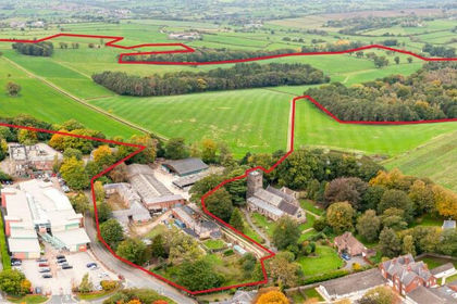
- Price
- Guide Price£2,400,000
- Size
- 192.69 acres
Hall Farm, Church Street, Alfreton, Alfreton, Derbyshire DE55 England
Added on 28/01/2026Farmhouse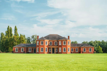
- Price
- Offers in Region of£2,500,000
- Size
- 13 acres
Ranskill Road, Mattersey, Doncaster, Mattersey, Nottinghamshire DN10 England
Added on 10/08/2026House with Land