Brampton Ash Estate, Near Market Harborough
- Land size
- 856.86 acres
Key Features
- Ring-fenced agricultural, sporting and amenity estate extending to approximately 856.86 acres (346.76 hectares)
- Offered mainly freehold (856.00 acres) with minor leasehold interest (0.86 acres)
- Predominantly in - hand, other than leased woodland
- Productive arable and pastureland
- Attractive mature woodland
- Centrally - located Shoot Lodge and associated traditional brick - built buildings with development potential
- Traditional brick-built farm buildings with development potential
- Accessible yet secluded rural location
- Offered for sale as a whole or in two lots
Description
Situation & Location
Brampton Ash Estate is situated near Market Harborough, on the borders of South Leicestershire and North Northamptonshire. The property enjoys a strategic yet peaceful rural location, benefiting from excellent transport connections.
The Estate Lies:
* South of the A427
* North of the A6
* Accessible to A14 (3 Miles)
* Within easy reach of Leicester, Northampton and London via mainline rail
* Accessible to East Midlands Airport (30miles) and Birmingham International Airport (40miles)
Market Harborough provides a wide range of services, schooling, and mainline rail connections to London St Pancras.
The Estate lies within the Pytchley Hunt country, with further hunting nearby with the Fernie, Cottesmore and Quorn Hunts in an area renowned for field sports.
The Estate
The property comprises the central and major core of the former Brampton Ash Estate and it now extends to approximately 856.86 Acres (346.76 Hectares). The land is arranged in two adjacent blocks either side of the minor public road linking Brampton Ash village to the north, to Hermitage hamlet to the south.
The eastern block only is affected by public rights of way, and to a limited extent.
The gently undulating land form with a mainly southerly aspect, provides for productive farming, and strategically - located woodland combining to provide significant sporting and amenity appeal.
Farmland
The land is gently undulating with a mainly southerly aspect being conducive to highly productive farming and suitable for the growing of high yielding winter cereals and grass It is being classified Grade 3 in the former MAFF Land Classification Series.
The soils are predominantly freely draining, slightly acidic, and base-rich, together with slowly permeable, seasonally wet clay soils (source Soil Maps of England & Wales 1983)
The land lies within a Nitrate Vulnerable Zone, and the arable land is currently farmed under a Contract Farming Agreement, expiring after - harvest 2026.
Grassland is occupied in-hand and under short - term grazing agreements.
Further details are available to interested parties upon application to the Vendors agents, as part of the Information Pack.
In-Hand Woodland
The estate benefits from approximately 124.28 acres of mature woodland, mainly indigenous hardwood species in character and managed both for timber production and for amenity/ sporting. These areas enhance biodiversity, sporting interest and amenity value, and provide opportunities for conservation, carbon and natural capital initiatives.
All in-hand timber rights insofar as they are owned, are included in the sale
Leased Woodland
Brampton Wood extending to 149.09 acres is let subject to a 999 - year lease which commenced 11th August 1958 in favour of the Forestry Commission at an annual rent of approximately £18.00.
Further details are available to interested parties upon application to the Vendors agents, as part of the Information Pack.
Buildings
Shoot Lodge
And associated traditional buildings
This centrally - located range of traditional brick-built former farm buildings, forming part of Lot 1, are currently used as a well - appointed shoot lodge and for general farm storage. The buildings may offer potential for alternative uses under permitted development, subject to obtaining the necessary consents.
All items normally designated as tenant's fixtures and fittings are excluded from the sale, although some may be available to a purchaser by separate negotiation.
Details of existing change of use planning permission are available to interested parties upon application to the Vendors agents, as part of the Information Pack.
Red Hovel
A separate range of traditional agricultural buildings, positioned towards the north-eastern edge of the eastern block and forming part of Lot 2, are currently used for informal farm storage.
These buildings offer strong potential for conversion or redevelopment, subject to necessary planning consents. A pre-application application for residential use has been submitted to North Northamptonshire Council, supported by a detailed structural survey report.
Further details are available to interested parties upon application to the Vendors agents, as part of the Information Pack.
General Remarks & Stipulations
Planning and Local Authority
The property lies within the North Northamptonshire Council unitary administrative district, subject to countryside planning policies and located outside settlement boundaries and conservation areas.
However, it is believed there may be potential for change of use of the buildings under Classes Q (residential) and R (commercial/employment), subject to obtaining the necessary consents. Prospective purchasers are advised to make their own planning enquiries to.
North Northamptonshire Council
Strategic Policy, Design & Delivery
Cedar Drive, Thrapston, NN14 4LZ
Services
* Mains water supply is available to the Shoot Lodge and to other parts of the Estate.
* Mains electricity is available to the Shoot Lodge
Further details are available to interested parties upon application to the Vendors agents, as part of the Information
Tenure & Possession
Some 855.30 acres are offered freehold, as detailed under Land Registry Title No. NN296886, and a further 0.86acres as a 999-year leasehold interest which is shown by a solid green line on the plan annexed to these particulars.
The whole is offered with vacant possession, apart from Brampton Wood (approximately 149.09acrs), described above.
Further details are available to interested parties upon application to the Vendors agents, as part of the Information Pack.
Wayleaves & Easements
The property is sold subject to and with the benefit of all existing rights of way, whether public or private, whether specifically mentioned or not.
Further details are available to interested parties upon application to the Vendors agents, as part of the Information Pack.
Adjacent Farmland
The Vendor has for some years occupied 50.88 acres of adjacent arable land on a Farm Business Tenancy. Enquiries of the adjacent landowner suggest the successful purchaser may continue this arrangement.
Further details are available to interested parties upon application to the Vendors agents, as part of the Information Pack.
ENVIRONMENTAL & SUBSIDY SCHEMES
There are currently no Environmental Stewardship agreements in place and no usable Basic Payment Entitlements Whilst in the past there have been Forestry Grant schemes in place there are no such schemes currently in operation.
Details of previous schemes are available to interested parties upon application to the Vendors agents, as part of the Information Pack.
Sporting & Amenity
The Estate has for many years been managed for conservation, environmental enhancement and amenity uses, with the creation of a renowned pheasant and partridge shoot, both driven and walked-up. The property is therefore well suited to private ownership, institutional investment, and to natural capital projects.
All items associated with the shoot normally designated as tenants' fixtures and fittings are excluded from the sale, although some may be available to a purchaser by separate negotiation.
In the recent past, short - term licences have been negotiated with the Forestry Commission for limited use of Brampton Wood in connection with organised shoot days, although there are currently no such arrangements in place.
Further details are available to interested parties upon application to the Vendors agents, as part of the Information Pack.
Lotting
Lot 1 - Main Estate
Approx. 834.39 acres including arable land, woodland, pasture and shoot lodge.
Lot 2 - Red Hovel
Approx. 22.47 acres including traditional farm buildings and surrounding grassland.
Plans & Schedules
A full schedule of the Estate and associated plans are available to interested parties upon application to the Vendors agents, as part of the Information Pack.
Method of Sale
The property is offered for sale by Private Treaty, as a whole or in two lots. The vendor reserves the right to conclude the sale by informal tender or best and final offers.
Solicitors
Knights
Victoria, Hudson Quarter, York, YO1 6AB
Viewings
Strictly by appointment through the selling agents. Viewings are permitted during daylight hours only.
Important Notice
Prospective purchasers must satisfy themselves as to the accuracy of all information, boundaries, services, planning and areas. Plans are for identification purposes only and are not to scale.
Contact
Rupert West FRICS
Jessica Deacon
For further information or to arrange a viewing, please contact the selling agents.
Map Location
Property details
- Tenure
- Ask Agent
- Council Tax Band
- Ask Agent
- Date Posted
- 2026-05-19
Utilities & Restrictions
Utilities
- Electricity
- Ask Agent
- Water
- Ask Agent
- Heating
- Ask Agent
- Broadband
- Ask Agent
- Sewerage
- Ask Agent
Rights & Restrictions
- Public Rights of Way
- Ask Agent
- Private Rights of Way
- Ask Agent
- Listed Property
- Ask Agent
- Restrictions
- Ask Agent
Listed status, conservation areas and planning constraints for this location are in the full report.
Property Features
- Accessibility
- Ask Agent
- Parking
- Parking Available
- Garden
- Ask Agent
Beyond the particulars: planning activity, flood history, heritage and ground risks, checked for this exact spot.
Connectivity
Broadband
Fastest speed available at this postcode
15 Mbps
Standard (10-30 Mbps)
Suitable for
- Web & social
- Music streaming
- Standard video calls
Mobile signal
Outdoor predictions; indoor signal depends on building materials.
Ofcom Connected Nations postcode-level predictions. Speeds and signal are modelled, not measured, and vary between addresses and providers.
Signal is the easy part. Planning activity, flood history and protected designations here are in the full report.
Nearest Schools
Primary
- Loatlands Primary School1.4 milesNo Ofsted rating
- Ages
- 3 to 11
- Pupils
- 446
- Type
- Academy converter
- Havelock Infant School1.5 milesNo Ofsted rating
- Ages
- 5 to 7
- Pupils
- 175
- Type
- Academy converter
- Havelock Junior School1.6 milesNo Ofsted rating
- Ages
- 7 to 11
- Pupils
- 306
- Type
- Academy converter
- Wilbarston Church of England Primary School1.8 milesOfsted: Good
- Ages
- 4 to 11
- Pupils
- 62
- Type
- Academy converter
- Faith
- Church of England
- Rothwell Junior School2.9 milesOfsted: Inadequate *
- Ages
- 7 to 11
- Pupils
- 315
- Type
- Academy converter
Secondary
- Montsaye Academy2.8 milesOfsted: Inadequate
- Ages
- 11 to 18
- Pupils
- 1,017
- Type
- Academy converter
- Welland Park Academy4.1 milesNo Ofsted rating
- Ages
- 11 to 16
- Pupils
- 1,014
- Type
- Academy converter
- Kingswood Secondary Academy4.1 milesNo Ofsted rating
- Ages
- 11 to 18
- Pupils
- 1,208
- Type
- Academy sponsor led
- The Robert Smyth Academy4.3 milesNo Ofsted rating
- Ages
- 11 to 19
- Pupils
- 1,349
- Type
- Academy converter
- Brooke Weston Academy4.9 milesOfsted: Good
- Ages
- 11 to 18
- Pupils
- 1,154
- Type
- Academy sponsor led
* Latest graded judgement covers quality of education only; no overall grade was issued under the 2024-25 inspection framework.
Distances are straight-line from the advertised location. Source: the national school registers (DfE, Welsh Government, Scottish Government) and Ofsted.
Schools are just the start: sold prices nearby, planning activity and any flood history are in the full report.
Amenities
Supermarket
GP surgery
Pharmacy
Hospital
Green space
Straight-line distances from the advertised location. Sources: NHS records, Geolytix supermarket locations, OS Open Greenspace and the national trails registers.
The area stacks up? Now check the location itself: planning nearby, protected designations and past flooding.
Getting Around
Nearest station
Nearest bus stop
Typical drive times
Straight-line distances from the advertised location; drive times are typical free-flow times over OpenStreetMap road data, so allow more at peak. Public transport locations from DfT NaPTAN.
Easy to reach matters. So do planning activity, flood history and ground risks: all in the full report.
Flood Risk
From Environment Agency flood map open data, checked around the advertised map pin and allowing for the listed acreage where known. This summary comes from LandSale, the advertising platform, not from the listing agent, and is not part of the agent's particulars. Risk can vary across a single holding, so verify anything critical through your own searches before committing.
Rivers and the sea
Surface water
Mapped within the area searched, not at the advertised map pin itself.
The detail behind these bandings
The full report pinpoints where this location sits on the flood maps, and runs the deeper checks that usually only surface after an offer.
- Exact flood zones & annual chances (included in the full report)
- Any recorded past flooding (included in the full report)
- Planning activity nearby (included in the full report)
- Heritage & conservation (included in the full report)
- Protected nature designations (included in the full report)
- Ground risks (included in the full report)
- Sold prices nearby (included in the full report)
£14.99 · one-off purchase
By LandSale, the platform. Not provided by the listing agent. Ready in about a minute.
Important notice: Information, maps and tags on this page are drawn from the advertising agent's marketing materials or generated automatically. LandSale has not verified them. Relying on these details is at your own risk, always carry out independent checks before committing to a purchase.
LandSale full disclaimer
Marketing information only - not formal particulars. The details on this website are provided for general guidance and do not constitute an offer or contract. Neither LandSale nor the advertising estate/land agent accepts responsibility for any inaccuracy.
1. Source of information
- Listing content: Core description, asking price, tenure, measurements, photographs and planning history originate from the marketing materials of the advertising estate or land agent. LandSale does not author this content and cannot guarantee its accuracy.
- Automated tags & categorisation: Property type, land-use class, acreage bands and similar labels may be applied by machine-learning models. They are intended as a helpful guide only and may not reflect the property's legal status or permitted use.
- Third-party & enriched data layers: Maps, boundary outlines, planning designations, soil reports, broadband coverage and other environmental or location-based insights are licensed from external suppliers. Such data are supplied “as is", may be incomplete or out of date and are subject to change without notice.
2. Verification required
Prospective purchasers must verify critical matters, including but not limited to planning permission, title boundaries, public rights of way, environmental constraints, acreage, services, access and VAT status, through their own inspections, specialist surveys, legal advisers and the selling agent before relying on the information or entering into any contract.
3. No warranty or liability
LandSale gives no warranty, express or implied, as to the accuracy, completeness or fitness for any particular purpose of the information displayed. LandSale shall not be liable for any loss, damage, cost or expense arising directly or indirectly from any use of or reliance on such information, save where liability may not be excluded by law.
4. Updates & feedback
If you believe any detail on this listing is inaccurate, please let us know. We will investigate and, where appropriate, update the listing or notify the agent.
© LandSale | Version 1.3 - August 2026
Listing agent
King West, Market Harborough
10 Church Square, Market Harborough, LE16 7NB
View agent profileSimilar properties for sale
- Price
- Guide Price£6,160,000
- Size
- 575 acres
Added on 17/06/2026Farmland
- Price
- £550,000
- Size
- 46.75 acres
Off Lyddington Road, Caldecott, Leicestershire, Caldecott, Rutland LE16 England
Added on 12/08/2026Agricultural Land
- Price
- £550,000
- Size
- 46.75 acres
Off Lyddington Road, Caldecott, Leicestershire, Caldecott, Rutland LE16 England
Added on 12/08/2026Agricultural Land
- Price
- Guide Price£180,000
- Size
- 26.66 acres
Land at Gretton, Northamptonshire - About 26.66 acres, Gretton, North Northamptonshire NN17 England
Added on 02/06/2026Farmland
- Price
- Guide Price£155,000
- Size
- 15.37 acres
Added on 26/08/2026Grazing Land
- Price
- POA
- Size
- 3.3 acres
Added on 03/07/2026Development Land
- Price
- Guide Price£2,500,000
- Size
- 80.7 acres
Added on 28/04/2026Farm- Price
- Guide Price£2,500,000
- Size
- 80.7 acres
Added on 16/05/2026Farm
- Price
- £170,000
- Size
- 13.85 acres
Land off the A428 Crick Northamptonshire, Crick, West Northamptonshire NN6 England
Added on 12/08/2026Agricultural Land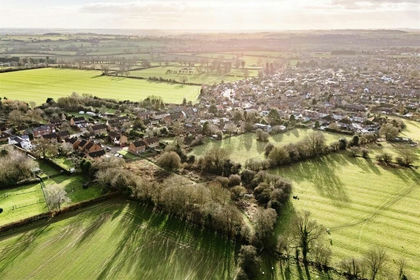
- Price
- Guide Price£275,000
- Size
- 1.73 acres
Stenhouse Close, Long Buckby, Long Buckby, West Northamptonshire NN6 England
Added on 04/02/2026Undeveloped Land