
1.87 Acres - Lot 1 Land At Cawsand, Rockside, Sticklepath, Okehamption, EX20
- Land size
- 1.87 acres
Key Features
- 26.46 acres (10.70 hectares)
- Permanent Pasture
- Natural Regeneration Woodland/Copse and Habitat
- Elevated Position with far reaching views
Description
Lot 1: 1.87 acres (0.75 hectares) of permanent pasture comprising two stoned walled fields.
For Sale by Private Treaty
DESCRIPTION
The land at Cawsand offers purchasers a rare opportunity to acquire useful grazing and habitat copse/woodland in an elevated position overlooking Sticklepath and surrounding villages and beyond. The lower sections of the land have partially rewilded into attractive and secluded copse/woodland with a peaceful and private setting offering opportunities for both tranquil rural use as habitat or grazing use to the various sections. The land is accessed via a variety of routes including footpaths or 4x4 from various adjoining paths and tracks and also across the high moor itself.
The land extends in total to 26.46 acres (10.70 hectares) with the land being offered as two convenient lots or as a whole. The full extent of the land is clearly delineated and edged red on the accompanying plan.
THE LAND
The land extends in total to 26.46 acres (10.70 hectares) with the land comprised of two sections with the smaller section (Lot 1) to the south and the larger section (Lot 2) to the north.
LOT 1
Comprised of two permanent pasture fields which are both granite stone walled and with access to the higher western side of the land via approx. 8’0 gateways onto the adjoining high moor. The land is gently east facing and free draining and there is a spring that rises to on the land which is understood to provide water but which may dry up during drier summer months.
LOT 2
Lot 2 extends in total to 24.59 acres (9.95 hectares) and the main northern section being comprised of ten fields/parcels with 10.94 acres (4.43 hectares) of permanent pasture and rough grazing and 13.65 acres (5.52 hectares) of copse/woodland/habitat areas which is primarily to the north and eastern lower sections of the land. The field boundaries are primarily granite stone walled and the land has considerable character.
The higher sections of pasture has some stoner sections giving the land character and the lower copse/woodland areas are primarily granite clicker/stone through sections giving the land character. The lower northern/eastern sections of copse/woodland include holly, blackthorn, hazel and birch and currently is providing a wonderful wildlife haven and habitat area.
The land offers purchasers a wonderful opportunity to farm, control and manage an unspoilt section of the Dartmoor countryside with the land offering more open land with views and also more private sections of habitat.
The land benefits from a building to the north-east of the land which is an approx. 20’0 x 15’0 traditional stone building constructed of granite stone under a part wooden frame GI sheet roof which offers shelter/storage options for prospective purchasers. There is a access point directly from the bottom footpath close to the building to the north-east. This building is located to the lower north-eastern side of OS8157.
SITUATION
The land is situated to the north-east edge of the scenic Dartmoor National Park lying directly above Rockside and Sticklepath but the land being within 2 miles to the south of the A30 dual carriageway. The town of Okehampton lies within 4 miles to the north-west and affords a thriving active community and range of amenities to include primary and secondary schools, traditional Inns, bustling streets and a railway link to Exeter and beyond. The city of Exeter lies approximately 24 miles to the north-east with mainline rail links to London Paddington.
DIRECTIONS
From the A30 turn off either at Whiddon Down to the east or Coombehead to the west following signs to South Zeal and then follow the signs towards Moorside.
For access to the north of the land, turn right passing Owlsfoot Garage on your left, take the left hand fork and continue up the hill/Prospect Lane. There are various pedestrian tracks from this point which lead up to the north-east and north-western side of the land. This is the best advisable access route.
BASIC PAYMENT SCHEME/AGRI– ENVIRONMENT SCHEMES
The land is being sold without any entitlements to the Basic Payments Scheme or any de-linked payments. The land area is not subject to any agri-environmental schemes.
ACCESS, RIGHTS OF WAY, EASEMENTS
Access to the land is via both 6’0/8’0/10’0 wooden gates to the higher/south-western side of the land via 4x4/quad bike access from Brians Lane and Nine Stones access points to the south and of the land which gives access to the higher moor section and pedestrian access and also further pedestrian access to the bottom north-eastern side of the land via Nine Stones/Prospect Lane. There is also a further access which is via pedestrian walkways to the north-west and bottom north-eastern corner from Prospect Lane. Purchasers are to make their own assumptions regarding access and must make their own assumptions regarding access available.
SERVICES
The land benefits from natural water supplies from springs and streams that rise and run across some sections of the land.
TOWN AND COUNTRY PLANNING
The property, notwithstanding any description contained in these particulars, is sold subject to any Development Plan, Tree Preservation Order, Town Planning Scheme, Resolution Notice, which may be or may come to be in force an also subject to any statutory provision or by-laws without any obligation on the part of the vendor to specify them.
OUTGOINGS
The agents are of the understanding there are no outgoings.
MOORLAND/COMMON GRAZING RIGHTS
The land benefits from 48 livestock units/grazing rights on CL176 South Tawton Commons (entry 15) and CL164 Forest of Dartmoor (entry 423). These rights are split 46 livestock/rights on the main block (Lot 2) and 2 livestock units/grazing rights on the top/Lot 1.
BIODIVERSITY NET GAIN
The land will be sold subject to a Biodiversity Net Gain Covenant that the vendors will reserve the right to a payment of 20% of any BNG payments obtained by the new owners/purchasers.
TENURE
The land is of Freehold tenure offering vacant possession at the completion of the sale.
LOCAL AUTHORITY
Dartmoor National Park, Parke, Bovey Tracey, Newton Abbot, Devon, TQ13 9JQ Tel: 01626 832093
METHOD OF SALE
We are offering the land freehold for sale via Private Treaty, either as a whole or two separate lots with the invitation for bids for Lot 1 in excess of £15,000, Lot 2 in excess of £80,000 or as a whole in excess of £95,000. All bids submitted will be disclosed to existing bidders but no information regarding bidder. Bidders will be given the opportunity of revising their bids if exceeded by bids received from third parties.
STATUS
Bidders will be required to confirm their status when submitting offers and would need to advise us if their purchase is subject to any other sales or funding.
ACCEPTANCE OF BIDS
On submitting the final highest bid, prospective purchasers will be advised that this is accepted subject to contract and will be expected to sign a contract within four weeks of the receipt of the contract. Failure to do so may result in a contract being offered to an underbidder. The vendor reserves the right not to accept the highest or any bids.
IMPORTANT NOTICE
For clarification we wish to inform any prospective purchasers that we have prepared these sales particulars as a general guide. They must not be relied upon as statements of fact. We have not carried out a detailed survey. If there are points which are of particular importance to you please contact the office prior to viewing the property.
Map Location
Property details
- Tenure
- Ask Agent
- Council Tax Band
- TBC
- Date Posted
- 2026-05-12
Market Value Analysis
Compared with 287 Farmland & Pasture listings in South West England (1+ acres).
Property Brochure
Seen the details? The full report adds the independent checks: planning activity, flood history, heritage and ground.
Utilities & Restrictions
Utilities
- Electricity
- Ask Agent
- Water
- Ask Agent
- Heating
- Ask Agent
- Broadband
- Ask Agent
- Sewerage
- Ask Agent
Rights & Restrictions
- Public Rights of Way
- Ask Agent
- Private Rights of Way
- Ask Agent
- Listed Property
- Ask Agent
- Restrictions
- Ask Agent
Listed status, conservation areas and planning constraints for this location are in the full report.
Property Features
- Accessibility
- Ask Agent
- Parking
- Parking Available
- Garden
- Ask Agent
Beyond the particulars: planning activity, flood history, heritage and ground risks, checked for this exact spot.
Connectivity
Broadband
Fastest speed available at this postcode
1.8 Gbps
Gigabit full fibre
Suitable for
- 4K streaming on every screen
- Full-time home working
- Online gaming & big downloads
Mobile signal
Predicted 4G and 5G signal; indoor signal depends on building materials.
Ofcom Connected Nations postcode-level predictions. Speeds and signal are modelled, not measured, and vary between addresses and providers.
Signal is the easy part. Planning activity, flood history and protected designations here are in the full report.
Nearest Schools
Primary
- South Tawton Primary School1 mileNo Ofsted rating
- Ages
- 2 to 11
- Pupils
- 201
- Type
- Academy converter
- St James Church of England Primary and Nursery School3.9 milesOfsted: Good
- Ages
- 2 to 11
- Pupils
- 244
- Type
- Free schools
- Faith
- Church of England
- Chagford Church of England Primary School4.3 milesOfsted: Good
- Ages
- 2 to 11
- Pupils
- 137
- Type
- Academy converter
- Faith
- Church of England
- Okehampton Primary School and Foundation Unit4.4 milesNo Ofsted rating
- Ages
- 2 to 11
- Pupils
- 420
- Type
- Academy converter
- Spreyton School4.4 milesOfsted: Good *
- Ages
- 3 to 11
- Pupils
- 30
- Type
- Foundation school
Secondary
- Okehampton College4 milesOfsted report card · Jan 2026
- Ages
- 11 to 18
- Pupils
- 1,066
- Type
- Academy converter
- Queen Elizabeth's12 milesOfsted report card · May 2026
- Ages
- 11 to 18
- Pupils
- 1,096
- Type
- Academy converter
- Chulmleigh Community College14 milesNo Ofsted rating
- Ages
- 11 to 16
- Pupils
- 735
- Type
- Academy converter
- South Dartmoor Community College15 milesOfsted: Good *
- Ages
- 11 to 18
- Pupils
- 801
- Type
- Academy converter
- Tavistock College16 milesOfsted: Requires improvement
- Ages
- 11 to 18
- Pupils
- 1,200
- Type
- Academy converter
* Latest graded judgement covers quality of education only; no overall grade was issued under the 2024-25 inspection framework.
Distances are straight-line from the advertised location. Source: the national school registers (DfE, Welsh Government, Scottish Government) and Ofsted.
Schools are just the start: sold prices nearby, planning activity and any flood history are in the full report.
Amenities
Supermarket
GP surgery
Pharmacy
Hospital
Straight-line distances from the advertised location. Sources: NHS records, Geolytix supermarket locations, OS Open Greenspace and the national trails registers.
The area stacks up? Now check the location itself: planning nearby, protected designations and past flooding.
Getting Around
Nearest station
Nearest bus stop
Typical drive times
Straight-line distances from the advertised location; drive times are typical free-flow times over OpenStreetMap road data, so allow more at peak. Public transport locations from DfT NaPTAN.
Easy to reach matters. So do planning activity, flood history and ground risks: all in the full report.
Flood Risk
Environment Agency open data, checked around the advertised map pin for the listed acreage. Long-term risk counts flood defences; the planning map's flood zones do not. Provided by LandSale, not the listing agent, and not part of the agent's particulars. Risk varies across a holding, so verify before committing.
Rivers and the sea
Planning map: Flood Zone 1.
Surface water
These bandings are the summary. Where this location sits on the flood maps, plus planning activity, heritage and ground risks, is in the full report.
Important notice: Information, maps and tags on this page are drawn from the advertising agent's marketing materials or generated automatically. LandSale has not verified them. Relying on these details is at your own risk, always carry out independent checks before committing to a purchase.
LandSale full disclaimer
Marketing information only - not formal particulars. The details on this website are provided for general guidance and do not constitute an offer or contract. Neither LandSale nor the advertising estate/land agent accepts responsibility for any inaccuracy.
1. Source of information
- Listing content: Core description, asking price, tenure, measurements, photographs and planning history originate from the marketing materials of the advertising estate or land agent. LandSale does not author this content and cannot guarantee its accuracy.
- Automated tags & categorisation: Property type, land-use class, acreage bands and similar labels may be applied by machine-learning models. They are intended as a helpful guide only and may not reflect the property's legal status or permitted use.
- Third-party & enriched data layers: Maps, boundary outlines, planning designations, soil reports, broadband coverage and other environmental or location-based insights are licensed from external suppliers. Such data are supplied “as is", may be incomplete or out of date and are subject to change without notice.
2. Verification required
Prospective purchasers must verify critical matters, including but not limited to planning permission, title boundaries, public rights of way, environmental constraints, acreage, services, access and VAT status, through their own inspections, specialist surveys, legal advisers and the selling agent before relying on the information or entering into any contract.
3. No warranty or liability
LandSale gives no warranty, express or implied, as to the accuracy, completeness or fitness for any particular purpose of the information displayed. LandSale shall not be liable for any loss, damage, cost or expense arising directly or indirectly from any use of or reliance on such information, save where liability may not be excluded by law.
4. Updates & feedback
If you believe any detail on this listing is inaccurate, please let us know. We will investigate and, where appropriate, update the listing or notify the agent.
© LandSale | Version 1.3 - August 2026
Listing agent
Greenslade Taylor Hunt, Ivybridge
8 Erme Ct Leonards Road, Ivybridge, PL21 0SZ
View agent profileSimilar properties for sale
- Price
- Guide Price£8,000
- Size
- 0.12 acres
Plot A4, Hollacombe, Holsworthy, Clawton, Devon, EX226NL, Holsworthy Hamlets, Devon EX22 England
Added on 02/07/2026Small Plot of Land
- Price
- Offers in Region of£12,500
Winson Cross, Chittlehampton, Chittlehampton, Devon EX37 England
Added on 28/01/2026Small Plot of Land
- Price
- Offers in Region of£22,000
- Size
- 0.29 acres
Added on 31/03/2026Pasture
- Price
- Guide Price£25,000
- Size
- 1.92 acres
1.92 acres of land at Coldvreath, Roche, Roche, Cornwall PL26 England
Added on 21/09/2026Pasture
- Price
- Guide Price£30,000
- Size
- 1.84 acres
Morecombelake, Bridport, Whitchurch Canonicorum, Dorset DT6 England
Added on 08/10/2026Cheap Land
- Price
- £1
- Size
- 26.34 acres
Oaktree Way, Cannington, Bridgwater, TA5, Cannington, Somerset TA5 England
Added on 21/08/2026Agricultural Land
- Price
- £30,000
- Size
- 3.36 acres
Added on 22/09/2026Cheap Land
- Price
- £27,500
- Size
- 3.23 acres
Lot A Lot B Land, Langport, Bristol, TA10, Huish Episcopi, Somerset TA10 England
Added on 14/09/2026Farmland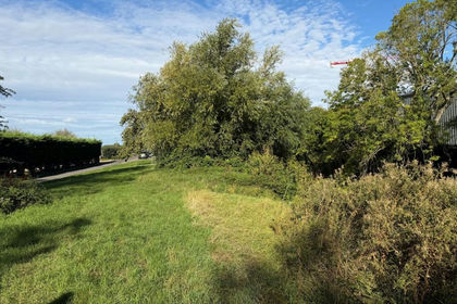
- Price
- Guide Price£20,000
- Size
- 0.35 acres
Lot B - Merry Lane, Bason Bridge, Highbridge, TA9, East Huntspill, Somerset TA9 England
Added on 01/10/2026Cheap Land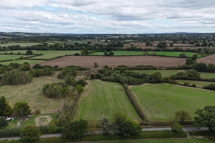
- Price
- Guide Price£30,000
- Size
- 1.84 acres
Land Opposite Winterhayes Farm, Yetminster, Sherborne, Yetminster, Dorset DT9 England
Added on 21/09/2026Pasture