Ilminster, Somerset, TA19
Key Features
- 38.55 acres (15.60 ha)
- Arable land with good direct road access
- For Sale by Informal Tender
- Three good sized parcels
Description
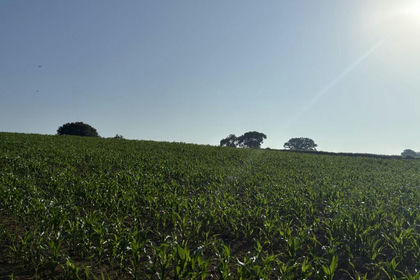
A highly productive block of gently undulating arable land with direct road access. In all 38.55 acres (15.60 ha)
Also available is Lot B 61.07 Acres or arable and pasture land.
LOT A GUIDE PRICE £365,000
Situated to the west of the two blocks and accessible from Copse Lane, across the area coloured and edged blue on the site plan. This land comprises three parcels and totals 38.55 acres (15.60 ha). The land is all utilised within the arable rotation and currently cropped with Oilseed .
METHOD OF SALE
The land will be offered for sale by Informal Tender (unless previously sold), as detailed within these sales particulars. All tenders should be submitted to the Agents FAO Abbie Lewis, Greenslade Taylor Hunt, Sedgemoor Auction Centre, North Petherton, Bridgwater, Somerset,
TA6 6DF by 12 noon on Friday 5th June 2026 and labelled as ’Lot A or Lot B - Land at Merryfield, Ilton Somerset’. Alternatively this can be emailed to Abbie Lewis.
ACCESS
As mentioned above, the land benefits from direct road access, offering great capability to get agricultural machinery on and off the land.
SOIL TYPE & TOPOGRAPHY
The land is level lying, with parts of slight Undulation. The soil is classified of a mixture of loamy and clayey soils, plus lime-rich loamy and clayey soils both of which have moderate to high levels of fertility. It is classified as Grade III on the Provisional Agricultural Land Classification Map.
DEVELOPMENT CLAWBACK
The land is not subject to any development clawback or overage.
SERVICES
We understand the land benefits from mains water, the meter is in Merryfield Lane. If the purchaser of Lot A is different to Lot B the purchaser of Lot A will need to install a sub-meter within 3 months of completion.
TENURE & POSSESSION
The land is subject to a Farm Business Tenancy until the 28th September 2026, early entry might be available subject to negotiation.
RIGHTS OF WAY, EASEMENTS, ETC.
There is no public rights of access across the land as far as our investigations have uncovered. The land is also free of any overhead wires of cabling and telegraph poles and pylons.
The property is offered for sale subject to and with the benefit of all matter contained in or referred in the property charges register of the
registered title together with all public and private rights of way, wayleaves, easements, and other rights of way whether specifically referred to or not.
BASIC PAYMENT SCHEME
The Basic Payment Scheme entitlements are not included in the sale. The land is subject to an existing Sustainable Farming Incentive agreement, options include CLIG3, GRH7, CAHL4, CHRW2 and
CHRW3.
SPORTING AND MINERAL RIGHTS
The sporting and mineral rights across the land, in so far as they are owned, will be included in the freehold sale.
In addition Lot B is available totalling 61.07 acres (24.71 ha) for a Guide Price of £580,000.
Map Location
Property details
- Tenure
- Freehold
- Council Tax Band
- TBC
- Date Posted
- 2026-05-02
Utilities & Restrictions
Utilities
- Electricity
- Ask Agent
- Water
- Ask Agent
- Heating
- Ask Agent
- Broadband
- Ask Agent
- Sewerage
- Ask Agent
Rights & Restrictions
- Public Rights of Way
- Ask Agent
- Private Rights of Way
- Ask Agent
- Listed Property
- Ask Agent
- Restrictions
- Ask Agent
Property Features
- Accessibility
- Ask Agent
- Parking
- Ask Agent
- Garden
- Ask Agent
Important notice: Information, maps and tags on this page are supplied by the advertising agent or generated automatically. LandSale has not verified them. Relying on these details is at your own risk, always carry out independent checks before committing to a purchase.
LandSale full disclaimer
Marketing information only - not formal particulars. The details on this website are provided for general guidance and do not constitute an offer or contract. Neither LandSale nor the advertising estate/land agent accepts responsibility for any inaccuracy.
1. Source of information
- Agent-supplied content: Core description, asking price, tenure, measurements, photographs and planning history are uploaded by the appointed agent, who remains solely responsible for their accuracy.
- Automated tags & categorisation: Property type, land-use class, acreage bands and similar labels may be applied by machine-learning models. They are intended as a helpful guide only and may not reflect the property's legal status or permitted use.
- Third-party & enriched data layers: Maps, boundary outlines, planning designations, soil reports, broadband coverage and other environmental or location-based insights are licensed from external suppliers. Such data are supplied “as is", may be incomplete or out of date and are subject to change without notice.
2. Verification required
Prospective purchasers must verify critical matters, including but not limited to planning permission, title boundaries, public rights of way, environmental constraints, acreage, services, access and VAT status, through their own inspections, specialist surveys, legal advisers and the selling agent before relying on the information or entering into any contract.
3. No warranty or liability
LandSale gives no warranty, express or implied, as to the accuracy, completeness or fitness for any particular purpose of the information displayed. LandSale shall not be liable for any loss, damage, cost or expense arising directly or indirectly from any use of or reliance on such information, save where liability may not be excluded by law.
4. Updates & feedback
If you believe any detail on this listing is inaccurate, please let us know. We will investigate and, where appropriate, update the listing or notify the agent.
© LandSale | Version 1.2 - January 2026
Listing agent
Greenslade Taylor Hunt, Taunton
13 Hammet Street, Taunton, TA1 1RN
Similar properties for sale
- Price
- Guide Price£420,000
- Size
- 32.69 acres
Land at Southtown Farm, Ashill, Ilminster, Somerset TA19 9LS, Ashill, Somerset TA19 9LR England
Added on 02/07/2026Arable Land
- Price
- Guide Price£300,000
- Size
- 40.52 acres
At Moor Road, Sutton Mallet, Bridgwater, Somerset, TA7, Stawell, Somerset TA7 9AR England
Added on 29/01/2026Arable Land
- Price
- Guide Price£320,000
- Size
- 25.74 acres
Ashcott, Bridgwater, Somerset, Ashcott, Somerset TA7 9QN England
Added on 29/01/2026Arable Land
- Price
- Guide Price£335,000
- Size
- 30.74 acres
Blackborough, Cullompton, Devon, EX15, Uffculme, Devon EX15 2JB England
Added on 04/06/2026Grazing Land
- Price
- Offers in Excess of£375,000
- Size
- 46 acres
Added on 28/04/2026Farmland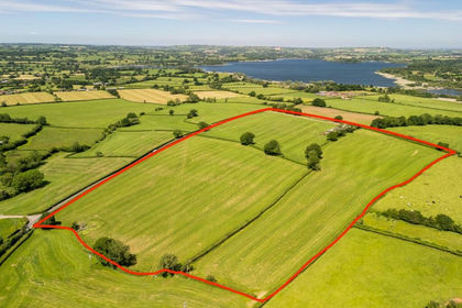
- Price
- Guide Price£400,000
- Size
- 32.98 acres
Bath Road, West Harptree, BS40, West Harptree, Bath and North East Somerset BS40 6DR England
Added on 25/06/2026Farm
- Price
- £312,000
- Size
- 35.37 acres
Lot 1: 35.37 of Land at Bolsters Wood, Exeter, Exeter, Devon EX4 2NY England
Added on 29/01/2026Vacant Land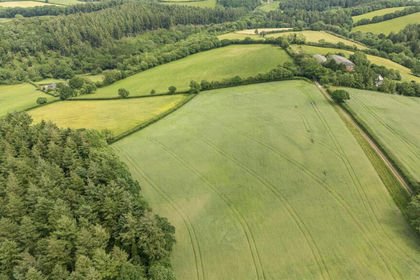
- Price
- Guide Price£280,000
- Size
- 30.47 acres
Added on 03/07/2026Vacant Land
- Price
- Guide Price£350,000
- Size
- 5.4 acres
The Barn at Oldford with full planning, Oldford, Frome, BA11, Selwood, Somerset BA11 2ND England
Added on 12/02/2026Conversion Land
- Price
- £275,000
- Size
- 9.25 acres
Added on 11/03/2026Equestrian property