Bronant, Aberystwyth, SY23
- Land size
- 67.5 acres
- Bedrooms
- 3
- Bathrooms
- 1
Key Features
- BRONANT, NR ABERYSTWYTH
- 107 acre stock farm
- Secluded location, including 39.5 acres of communal grazing rights
- Set around a period farmstead including a characterful Welsh longhouse *** Grade II listed
Description
*** 107 acre stock farm in Mid Ceredigion *** An opportunity to acquire a Freehold agricultural holding *** Upland location, south of Aberystwyth and north-west of Tregaron *** Secluded location, including 39.5 acres of communal grazing rights *** 67.5 acres of Freehold land with full vacant possession *** Set around a period farmstead including a characterful Welsh longhouse *** Grade II listed *** With untouched range of additional farm buildings *** Together with barns, stables, cow sheds and large more modern general purpose farm building suiting a variety of uses ***
Private water supply, mains electricity, private drainage to septic tank. Telephone subject to BT regulations. No heating.
Construction Type
Stone and slate
GENERAL
A 107 acre stock farm in noted agricultural locality to provide a beautiful upland farming opportunity, Nr Aberystwyth Mid Ceredigion, Mid Wales.
Secluded and set above the Teifi Valley and offering a wide range of lifestyle opportunities including conservation, agriculture, equestrianism, silvicultural or residential purposes. This is a rare opportunity to acquire a completed untouched agricultural holding in a sought after locality offering a host of alternative lifestyles. In total 107 acres or thereabouts including 39.5 acres of grazing adjacent (owned Freehold) over which there are 3rd party rights.
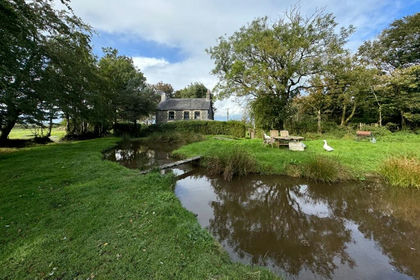
Bronfynwent is an historic traditional farm, extending to 107 acres or thereabouts and comprises period homestead with long house style stone and slate dwelling which is partially modernised.
Bronfynwent is a farm extending to 107 acres or thereabouts . It comprises a period homestead with a ‘longhouse style’ stone and slate built dwelling which is...
HALLWAY
With tiled flooring
LIVING ROOM
16’10 x 15’1 with Inglenook stone fireplace with log stove. Flagstone floor.
KITCHEN
13’9 x 8’ with thermoplastic tiled floor, cooker point, sink unit. Pantry off with shelving. Separate built in airing cupboard with copper cylinder and immersion heater.
BATHROOM
8’5 x 7’8 with panelled bath, pedestal wash hand basin. Thermoplastic tiled floor.
SEPARATE WC
With low level flush w.c.
RECEPTION ROOM OFF LIVING ROOM
15’1 x 7’4
BEDROOM 1
14’ x 8’2 with built in tank cupboard.
BEDROOM 2
14’ x 9’2
BEDROOM 3
14’ x 8 with Velux windows
THE FARM YARD
This is hard based, has running water, a number of pockets of woodland and is gated from a quiet district road.
The outbuildings comprise more particularly as follows:-
FUEL STORE
Of corrugated iron construction.
DETACHED GARAGE/WORKSHOP
30’ x 20’ of steel and corrugated iron
DERELICT STONE AND CORRUGATED IRON SHED
SHEEP/LAMBING SHED
MODERN CATTLE SHED
60’ x 42’ of steel block and corrugated iron with asbestos clad roof and fitted mangers. Constructed as a cattle shed, but more latterly utilised for general storage and sheep handling.
FURTHER STONE AND SLATE BARN
Adjacent to the house; 30’ x 18’
STABLE
18’ x 12’
TOP LAND
HILL LAND
LOWER LYING MEADOWS
The lower lying meadows in front of the Farmhouse adjoining the council road divided into traditionally sized enclosures with stone walls, fences and laid to pasture. There is some infestation of Rush and having previously been hay meadows, but equally, capable of being restored thereto
FORMER WOODLAND PARCELS
A number of former woodland parcels are encompassed within the farm, lying to the centre of the holding ready for re-establishment and possibly eligible for Grant Aid. - Further details available from NRW - NaturalResourcesWales.org
UPPER PASTURES
The upper pastures comprise of improved grazing and all under fence with further pockets of rough grazing and hill land that is more exposed to the elements. In all the property is all within a ring fence with the exception of 1 enclosure on the opposite side of the Council lane.
The land is naturally watered and capable of sustaining reasonable stocking levels.
This is a livestock rearing farm at relatively high altitude but within easy reach of market and amenity centres including Tregaron and Aberystwyth. In total extending to some 107 acres .
MONEY LAUNDERING REGULATIONS
The successful Purchaser will be required to produce adequate identification to prove their identity within the terms of the Money Laundering Regulations. Appropriate examples include Passport/Photo Driving Licence and a recent Utility Bill. Proof of funds will also be required or mortgage in principle papers if a mortgage is required.
AGENTS COMMENTS
NOTE: Part of the farm is Freehold but is registered with adjacent owners as open hill for communal grazing. This is enjoyed by the subject holding also over this Freehold land, and is a valuable add-on entity. Thus, in total 67 acres or thereabouts comprises the farm with the adjacent Freehold grazing rights of some 39.5 acres or thereabouts.
PUBLIC FOOTPATHS
The farm is traversed by a public footpath, north to south.
LISTED STATUS
The farmhouse is listed as being of historic interest as a Welsh longhouse. Further details available from CADW.org the Welsh Historic Monuments Trust of the Welsh Government.
TENURE AND POSSESSION
We are informed the property is of Freehold Tenure and will be vacant on completion. No onward chain.
The property is listed under the Local Authority of Ceredigion County Council. Council Tax Band - ??
Map Location
Property details
- Tenure
- Freehold
- Council Tax Band
- Ask Agent
- Date Posted
- 2026-05-02
Market Value Analysis
Compared with 59 Farms & Smallholdings listings in Wales (50+ acres).
Energy Performance Certificate
Energy Efficiency Rating
Based on UK Energy Performance Certificate standards (EU Directive 2002/91/EC)
Utilities & Restrictions
Utilities
- Electricity
- Mains
- Water
- Private Supply
- Heating
- Ask Agent
- Broadband
- Ask Agent
- Sewerage
- Septic Tank / Private
Rights & Restrictions
- Public Rights of Way
- Ask Agent
- Private Rights of Way
- Yes
- Listed Property
- Yes
- Restrictions
- Ask Agent
Property Features
- Accessibility
- Ask Agent
- Parking
- Parking Available
- Garden
- Garden
Important notice: Information, maps and tags on this page are supplied by the advertising agent or generated automatically. LandSale has not verified them. Relying on these details is at your own risk, always carry out independent checks before committing to a purchase.
LandSale full disclaimer
Marketing information only - not formal particulars. The details on this website are provided for general guidance and do not constitute an offer or contract. Neither LandSale nor the advertising estate/land agent accepts responsibility for any inaccuracy.
1. Source of information
- Agent-supplied content: Core description, asking price, tenure, measurements, photographs and planning history are uploaded by the appointed agent, who remains solely responsible for their accuracy.
- Automated tags & categorisation: Property type, land-use class, acreage bands and similar labels may be applied by machine-learning models. They are intended as a helpful guide only and may not reflect the property's legal status or permitted use.
- Third-party & enriched data layers: Maps, boundary outlines, planning designations, soil reports, broadband coverage and other environmental or location-based insights are licensed from external suppliers. Such data are supplied “as is", may be incomplete or out of date and are subject to change without notice.
2. Verification required
Prospective purchasers must verify critical matters, including but not limited to planning permission, title boundaries, public rights of way, environmental constraints, acreage, services, access and VAT status, through their own inspections, specialist surveys, legal advisers and the selling agent before relying on the information or entering into any contract.
3. No warranty or liability
LandSale gives no warranty, express or implied, as to the accuracy, completeness or fitness for any particular purpose of the information displayed. LandSale shall not be liable for any loss, damage, cost or expense arising directly or indirectly from any use of or reliance on such information, save where liability may not be excluded by law.
4. Updates & feedback
If you believe any detail on this listing is inaccurate, please let us know. We will investigate and, where appropriate, update the listing or notify the agent.
© LandSale | Version 1.2 - January 2026
Listing agent
Morgan & Davies, Lampeter
12 Harford Square, Lampeter, SA48 7DT
Similar properties for sale
- Price
- £595,000
- Size
- 34 acres
Trefenter, Aberystwyth, SY23, Llangwyryfon, Ceredigion SY23 4HE Wales
Added on 29/01/2026Smallholding
- Price
- Guide Price£675,000
- Size
- 71.73 acres
Tynygraig, Ystrad Meurig, Ystrad Meurig, Ceredigion SY25 6AJ Wales
Added on 20/05/2026Farm
- Price
- Guide Price£650,000
- Size
- 55.1 acres
Devils Bridge, Aberystwyth, Pontarfynach, Ceredigion SY23 4RE Wales
Added on 29/01/2026Farm
- Price
- Guide Price£650,000
- Size
- 58 acres
Neuaddlwyd, Aberaeron, SA48, Ciliau Aeron, Ceredigion SA48 7SJ Wales
Added on 29/01/2026Smallholding
- Price
- £800,000
- Size
- 70 acres
Rhandirmwyn, Llandovery, Carmarthenshire., Llanfair-ar-y-bryn, Carmarthenshire SA20 0PD Wales
Added on 20/05/2026Livestock Farm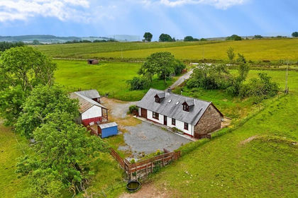
- Price
- £595,000
- Size
- 46 acres
Gwernogle, Carmarthen, Carmarthenshire., Llanfihangel Rhos-y-Corn, Carmarthenshire SA32 7RS Wales
Added on 29/01/2026Livestock Farm
- Price
- £745,000
- Size
- 62 acres
Crugybar, Llanwrda, Carmarthenshire., Cynwyl Gaeo, Carmarthenshire SA19 8UB Wales
Added on 29/01/2026Smallholding
- Price
- Offers in Region of£795,000
- Size
- 40 acres
Ffynnonwen, Coed Y Bryn, Ceredigion. SA44 5LZ, Troedyraur, Ceredigion SA44 5LZ Wales
Added on 07/07/2026Smallholding
- Price
- Guide Price£750,000
- Size
- 85 acres
Cwmifor, Llandeilo, Carmarthenshire., Manordeilo and Salem, Carmarthenshire SA19 7AT Wales
Added on 29/01/2026Farmland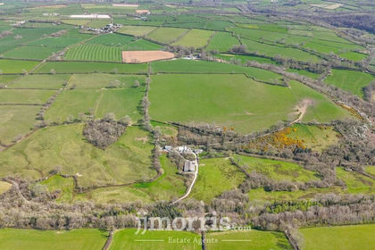
- Price
- £750,000
- Size
- 60 acres
Cwm Cou, Newcastle Emlyn, SA38, Beulah, Ceredigion SA38 9PR Wales
Added on 29/01/2026Farm