Church Street, Basingstoke, Hampshire
Key Features
- Rare freehold town centre opportunity
- Prominent retail frontage
- Opposite Festival Place shopping centre
- Approx. 1,579 sq ft over three floors
- Vacant possession
- Substantial upper parts
- Two rear parking spaces
- Development potential subject to planning
- Suitable for owner occupiers or investors
- No VAT payable
Description
Hindhead Property are delighted to present this rare opportunity to acquire a prominent freehold retail premises with substantial upper parts, positioned in the very heart of Basingstoke town centre, directly opposite the highly regarded Festival Place shopping centre.
Offered to the market with full vacant possession due to business relocation, this attractive and highly versatile property extends to approximately 1,579 sq ft and is arranged over ground, first and second floors. It presents an exceptional opportunity for owner occupiers, investors or developers seeking a well located asset with immediate usability and long term potential.
The ground floor provides a well configured retail unit with strong frontage and excellent natural visibility, benefitting from a good internal specification including laminate flooring, plastered ceilings and LED lighting. To the rear, the property offers additional storage, ancillary accommodation and a kitchen area, together with separate rear access for servicing and deliveries.
The upper parts are a standout feature of the property, offering a series of well proportioned rooms currently arranged as treatment spaces, all presented to a good standard and benefitting from air conditioning, gas central heating and modern finishes. These floors provide excellent flexibility, whether retained as ancillary accommodation, repurposed as office space or reconfigured to suit alternative uses, subject to the necessary consents.
The second floor further enhances the offering, providing additional open plan accommodation, a separate room and staff welfare facilities, creating a fully self contained and adaptable upper section.
Externally, the property benefits from two valuable parking spaces to the rear, accessed via Joyces Yard, a rare and highly desirable feature for a central town location.
The position of the property is a key driver of its appeal. Located directly opposite Festival Place, one of the region's primary retail and leisure destinations, the property enjoys consistently strong footfall and excellent connectivity. Basingstoke itself is a major commercial hub, with direct access to the M3 motorway and regular mainline rail services to London Waterloo in approximately 45 minutes, making it an attractive base for both regional and national occupiers.
This is a genuinely rare opportunity to secure a freehold asset in a prime trading location, offering immediate occupation alongside clear potential for asset management, income generation or future development, subject to planning.
Early enquiries are strongly advised.
Opportunities of this nature in such a prime position are seldom available and demand is expected to be strong.
BASINGSTOKE Basingstoke is a thriving commercial centre located approximately 45 miles south west of London, benefitting from excellent connectivity via Junctions 6 and 7 of the M3 motorway and easy access to the M4 via the A33. The town offers a fast and regular mainline rail service to London Waterloo in approximately 45 minutes, making it an attractive base for commuters and businesses alike. The property itself occupies a prime position on Church Street, directly opposite Festival Place, a dominant retail and leisure destination anchored by a strong mix of national and independent occupiers. This central location ensures consistent footfall, strong visibility and long term occupational demand, making it a highly desirable setting for both trading businesses and investors.
WHAT3WORDS ///tribes.poster.pill
VIEWINGS All enquiries, viewings and negotiations are to be conducted strictly through the instructed local agent:
Russell Ware
BDT
7 Faraday Office Park
Faraday Road
Basingstoke
Hampshire
RG24 8QB
Telephone:
Email: russell.
COMMERCIAL DISCLAIMER These particulars are for general guidance only and do not form part of any offer or contract. All descriptions, measurements, floor plans and information are provided in good faith but are approximate and not guaranteed.
Any reference to planning permission, building regulations, use class, development potential, listed status, conservation area or Tree Preservation Orders must be independently verified by the buyer or tenant with the relevant local authority.
All figures quoted for price, rent, business rates, service charges or yields are exclusive of VAT unless otherwise stated. Interested parties should satisfy themselves as to the incidence of VAT in any transaction.
Services, utilities, fixtures, fittings, systems and appliances have not been tested and no representation is made as to their condition or suitability. Buyers or tenants should also carry out checks for environmental risks including flood risk, invasive species, ground conditions and any other relevant matters.
Tenure, boundaries, access, rights of way, covenants, lease terms, repair obligations and any associated costs or taxes should be confirmed by a legal adviser.
Photographs, videos and marketing materials may be digitally enhanced, staged or illustrative and may not reflect the current condition.
Prospective buyers and tenants are strongly advised to carry out their own inspections, surveys and due diligence before entering into any agreement.
Hindhead Property Limited act as a partner agent where applicable and may not be the instructed agent handling negotiations.
Hindhead Property Limited accepts no liability for loss or damage arising from reliance on these particulars.
© Hindhead Property Limited 2026. All rights reserved.
Map Location
Property details
- Tenure
- Freehold
- Council Tax Band
- Ask Agent
- Date Posted
- 2026-04-24
Energy Performance Certificate
View the official EPC certificate for detailed energy efficiency information.
View official EPC certificate ↗
Running costs are one side. Planning activity, flood history and ground risks for this location are in the full report.
Utilities & Restrictions
Utilities
- Electricity
- Mains
- Water
- Mains
- Heating
- Gas Central Heating
- Broadband
- Cable Internet
- Sewerage
- Mains
Rights & Restrictions
- Public Rights of Way
- Ask Agent
- Private Rights of Way
- Ask Agent
- Listed Property
- Ask Agent
- Restrictions
- Ask Agent
Listed status, conservation areas and planning constraints for this location are in the full report.
Property Features
- Accessibility
- Ask Agent
- Parking
- Allocated Spot
- Garden
- Garden
Beyond the particulars: planning activity, flood history, heritage and ground risks, checked for this exact spot.
Connectivity
Broadband
Fastest speed available at this postcode
1.8 Gbps
Gigabit full fibre · available to 32% of premises
Suitable for
- 4K streaming on every screen
- Full-time home working
- Online gaming & big downloads
Mobile signal
Outdoor predictions; indoor signal depends on building materials.
Ofcom Connected Nations postcode-level predictions. Speeds and signal are modelled, not measured, and vary between addresses and providers.
Signal is the easy part. Planning activity, flood history and protected designations here are in the full report.
Nearest Schools
Primary
- Fairfields Primary School443 metresOfsted: Good
- Ages
- 4 to 11
- Pupils
- 403
- Type
- Community school
- St John's Church of England Voluntary Aided Primary School990 metresOfsted: Outstanding *
- Ages
- 4 to 11
- Pupils
- 312
- Type
- Voluntary aided school
- Faith
- Church of England
- Kings Furlong Infant School and Nursery0.7 milesOfsted: Requires improvement
- Ages
- 2 to 7
- Pupils
- 193
- Type
- Academy sponsor led
- Kings Furlong Junior School0.7 milesOfsted: Good *
- Ages
- 7 to 11
- Pupils
- 227
- Type
- Community school
- Rucstall Primary School0.7 milesOfsted: Outstanding
- Ages
- 4 to 11
- Pupils
- 204
- Type
- Community school
Secondary
- The Costello School656 metresOfsted report card · Feb 2026
- Ages
- 11 to 16
- Pupils
- 1,160
- Type
- Academy converter
- The Vyne Community School0.7 milesOfsted report card · Jun 2026
- Ages
- 11 to 16
- Pupils
- 740
- Type
- Community school
- Cranbourne0.8 milesOfsted report card · Jan 2026
- Ages
- 11 to 16
- Pupils
- 1,088
- Type
- Community school
- The Blue Coat School Basingstoke1.4 milesOfsted: Requires improvement
- Ages
- 11 to 16
- Pupils
- 837
- Type
- Academy sponsor led
- Everest Community Academy1.6 milesOfsted: Requires improvement *
- Ages
- 11 to 16
- Pupils
- 740
- Type
- Academy sponsor led
* Latest graded judgement covers quality of education only; no overall grade was issued under the 2024-25 inspection framework.
Distances are straight-line from the advertised location. Source: the national school registers (DfE, Welsh Government, Scottish Government) and Ofsted.
Schools are just the start: sold prices nearby, planning activity and any flood history are in the full report.
Amenities
Supermarket
GP surgery
Pharmacy
Hospital
Green space
Straight-line distances from the advertised location. Sources: NHS records, Geolytix supermarket locations, OS Open Greenspace and the national trails registers.
The area stacks up? Now check the location itself: planning nearby, protected designations and past flooding.
Getting Around
Nearest station
Nearest bus stop
Typical drive times
Straight-line distances from the advertised location; drive times are typical free-flow times over OpenStreetMap road data, so allow more at peak. Public transport locations from DfT NaPTAN.
Easy to reach matters. So do planning activity, flood history and ground risks: all in the full report.
Flood Risk
From Environment Agency flood map open data, checked around the advertised map pin and allowing for the listed acreage where known. This summary comes from LandSale, the advertising platform, not from the listing agent, and is not part of the agent's particulars. Risk can vary across a single holding, so verify anything critical through your own searches before committing.
Rivers and the sea
Surface water
The detail behind these bandings
The full report pinpoints where this location sits on the flood maps, and runs the deeper checks that usually only surface after an offer.
- Exact flood zones & annual chances (included in the full report)
- Any recorded past flooding (included in the full report)
- Planning activity nearby (included in the full report)
- Heritage & conservation (included in the full report)
- Protected nature designations (included in the full report)
- Ground risks (included in the full report)
- Sold prices nearby (included in the full report)
£14.99 · one-off purchase
By LandSale, the platform. Not provided by the listing agent. Ready in about a minute.
Important notice: Information, maps and tags on this page are drawn from the advertising agent's marketing materials or generated automatically. LandSale has not verified them. Relying on these details is at your own risk, always carry out independent checks before committing to a purchase.
LandSale full disclaimer
Marketing information only - not formal particulars. The details on this website are provided for general guidance and do not constitute an offer or contract. Neither LandSale nor the advertising estate/land agent accepts responsibility for any inaccuracy.
1. Source of information
- Listing content: Core description, asking price, tenure, measurements, photographs and planning history originate from the marketing materials of the advertising estate or land agent. LandSale does not author this content and cannot guarantee its accuracy.
- Automated tags & categorisation: Property type, land-use class, acreage bands and similar labels may be applied by machine-learning models. They are intended as a helpful guide only and may not reflect the property's legal status or permitted use.
- Third-party & enriched data layers: Maps, boundary outlines, planning designations, soil reports, broadband coverage and other environmental or location-based insights are licensed from external suppliers. Such data are supplied “as is", may be incomplete or out of date and are subject to change without notice.
2. Verification required
Prospective purchasers must verify critical matters, including but not limited to planning permission, title boundaries, public rights of way, environmental constraints, acreage, services, access and VAT status, through their own inspections, specialist surveys, legal advisers and the selling agent before relying on the information or entering into any contract.
3. No warranty or liability
LandSale gives no warranty, express or implied, as to the accuracy, completeness or fitness for any particular purpose of the information displayed. LandSale shall not be liable for any loss, damage, cost or expense arising directly or indirectly from any use of or reliance on such information, save where liability may not be excluded by law.
4. Updates & feedback
If you believe any detail on this listing is inaccurate, please let us know. We will investigate and, where appropriate, update the listing or notify the agent.
© LandSale | Version 1.3 - August 2026
Listing agent
Hindhead, Plymouth
18 Mannamead Road, Mutley, Plymouth, PL4 7AA
Similar properties for sale
 Added on 08/08/2026Building Plot
- Price
- Guide Price£350,000
- Size
- 0.8 acres
Range Road, Finchampstead, Wokingham, Berkshire, RG40, Finchampstead, Wokingham RG40 England
Added on 28/02/2026Development Land
- Price
- £425,000
Former Scout Hut Battery End, Newbury, Berkshire, RG14, Newbury, West Berkshire RG14 England
Added on 29/01/2026Development Land
- Price
- Guide Price£440,000
Land Adjacent To Hutts Farm, Blagrove Lane, Wokingham, RG41, Wokingham, Wokingham RG41 England
Added on 16/07/2026Self Build Plot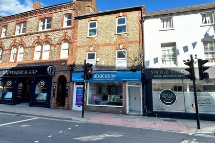
- Price
- Offers in Excess of£400,000
45 & 45A Cheap Street, Newbury, West Berkshire, RG14, Newbury, West Berkshire RG14 England
Added on 14/06/2026Development Land
- Price
- Guide Price£495,000
- Size
- 4.95 acres
Brocks Lane, Frilsham, Berkshire, RG18, Frilsham, West Berkshire RG18 England
Added on 13/06/2026Building Plot
- Price
- Guide Price£450,000
- Size
- 0.12 acres
Croft Lane, Newbury, Berkshire, RG14, Newbury, West Berkshire RG14 England
Added on 20/07/2026Building Plot
- Price
- Guide Price£350,000
- Size
- 0.21 acres
View, Pangbourne, RG8, Pangbourne, West Berkshire RG8 England
Added on 01/08/2026Small Plot of Land Added on 01/04/2026Building Plot
- Price
- £375,000
Building Plot Longmoor Road, Greatham, Greatham, Liss, Greatham, Hampshire GU33 England
Added on 08/04/2026Self Build Plot